

Underwater navigation
Encyclopedia
Navigation
Navigation is the process of monitoring and controlling the movement of a craft or vehicle from one place to another. It is also the term of art used for the specialized knowledge used by navigators to perform navigation tasks...
techniques learned by Scuba divers
Scuba diving
Scuba diving is a form of underwater diving in which a diver uses a scuba set to breathe underwater....
in order to accurately navigate in an underwater
Underwater
Underwater is a term describing the realm below the surface of water where the water exists in a natural feature such as an ocean, sea, lake, pond, or river. Three quarters of the planet Earth is covered by water...
environment.
Although it is considered a basic skill, it is normally only taught to a limited degree as part of basic Open Water certification. Most North American diver training agencies only teach significant elements of underwater navigation as part of the Advanced Open Water Diver
Advanced Open Water Diver
Advanced Open Water Diver is a scuba diving certification level provided by several diver training agencies, such as Professional Association of Diving Instructors , Scuba Schools International and Underwater Explorers' Federation...
certification program.
Underwater navigation is usually a core component of most, if not all, advanced diver training. In the PADI
Professional Association of Diving Instructors
The Professional Association of Diving Instructors is the world's largest recreational diving membership and diver training organization founded in 1966 by John Cronin and Ralph Erickson...
Advanced Open Water Diver course, it is one of the two mandatory skills (together with Deep diving
Deep diving
The meaning of the term deep diving is a form of technical diving. It is defined by the level of the diver's diver training, diving equipment, breathing gas, and surface support:...
) which must be taken alongside three elective skills.
Training agencies promote underwater navigation as a skill (despite the fact that it is less popular than other recreational diving specialties) on the basis that it:
- builds diver confidence
- saves energy by minimising excess swimming
- makes dive planning more effective
- keeps dive buddiesBuddy divingBuddy diving is the use of the buddy system by scuba divers and is a set of safety procedures that are intended to improve divers' chances of avoiding or surviving accidents in or under water by diving in a group of two or three divers...
together - reduces air consumption
Underwater navigation is a component of Underwater orienteering, combining Orienteering
Orienteering
Orienteering is a family of sports that requires navigational skills using a map and compass to navigate from point to point in diverse and usually unfamiliar terrain, and normally moving at speed. Participants are given a topographical map, usually a specially prepared orienteering map, which they...
, Scuba diving
Scuba diving
Scuba diving is a form of underwater diving in which a diver uses a scuba set to breathe underwater....
and Finswimming
Finswimming
Finswimming is the progression of a swimmer using monofins or normal swimfins either on the water surface or underwater, using only muscle strength. It is a discipline of underwater sports. The competition distances are same as for swimming...
.
Navigation techniques
Underwater navigation in recreational divingRecreational diving
Recreational diving or sport diving is a type of diving that uses SCUBA equipment for the purpose of leisure and enjoyment. In some diving circles, the term "recreational diving" is used in contradistinction to "technical diving", a more demanding aspect of the sport which requires greater levels...
is broadly split into two categories. Natural navigation techniques, and orienteering, which is navigation focused upon the use of an underwater magnetic compass
Compass
A compass is a navigational instrument that shows directions in a frame of reference that is stationary relative to the surface of the earth. The frame of reference defines the four cardinal directions – north, south, east, and west. Intermediate directions are also defined...
.
Natural navigation, sometimes known as pilotage, involves orienting by naturally observable phenomena, such as sunlight, water movement, bottom composition (for example, sand ripples always run parallel to the shore), bottom contour and noise. Although natural navigation is taught on courses, acquiring the skills is in the ordinary course more a matter of experience.
Orienteering, or compass navigation, is a matter of training and familiarity with the use of underwater compasses, combined with various techniques for reckoning distance underwater, including kick cycles (one complete upward and downward sweep of a kick), time, air consumption and occasionally (for shorter distances), by actual measurement.
Many skilled underwater navigators use techniques from both of these categories in a seamless combination, using the compass to navigate between landmarks over longer distances and in poor visibility, while making use of the generic oceanographic indicators to help stay on course and as a check that there is no mistake with the bearing, and then recognising landmarks and using them with the remembered topography of a familiar site to confirm position.
Landmarks
Recognisable topographical features may be remembered or noted and used to orientate yourself. This is particularly useful if the visibility allows you to see the next landmark on your route before leaving the last. Landmarks are ordinarily considered permanent or semi-permanent features, such as ridges, boulders, wrecks or clumps of weed, but use can also be made of temporary marks such as anchor cables, shot lines, jackstays and cave lines.Depth and depth variation
The slope of the bottom is often a reliable indicator of the direction toward the shore, particularly when the bottom is of soft or loose material, and is not broken up greatly by rocky outcrops. If you have access to a sufficiently detailed chart of the area, this information can be checked for reliability. Contours of depth running roughly parallel to the coastline indicate a slope dipping directly away from the shore, and can be used to maintain a sense of distance and orientation relative to the shore. In some places where the bottom is composed of predominantly rocky outcrops the slope may be in any direction and is not a reliable indictor of direction.Angle of the sun, changes in light level
If circumstances of depth and water clarity allow the position of the sun to produce sufficient variation in brightness , this may indicate the direction of the sun, and be used as a cue to orientation. The effect is greater if the sun is relatively low in the sky, the water is clean, the depth fairly shallow and the surface fairly smooth.In some circumstances you can look up at the surface, to see in which direction the land lies. These cues will not give any precise information about your position, but will allow you to keep a mental picture of where you are going.
Current, wave and surge direction
You can use current direction as an orientation cue as long as the direction of the current is known. In rivers it tends to be fairly consistent and reliable, though localised eddies may occur. In the sea it may depend on weather conditions and local topography, as well as the state of the tide. In estuaries and harbours the currents will usually be predominantly tidal, so the state of the tide must be known, as the difference in direction between ebb and flow is usually about 180°.Surge direction is essentially the same as wave direction, but may be felt at depths where the wave direction is no longer visible. It is useful if the offshore wave direction relative to the shore is known and does not change appreciably during the dive. In shallow water the wave crests will often be parallel to the shore. The important difference is that waves can be seen to travel in a definite direction, whereas surge is a back and forth motion, allowing a possible 180° error.
Ripple patterns on a sand bottom
A regular and distinct ripple pattern on a sand, mud or gravel bottom is an indication that it has been affected by wave action. The surge of the wave at depth causes the particles to be moved backwards and forwards in the direction the waves are travelling. This movement produces a ripple pattern on the bottom which is an indication of the wave direction on the surface. The ripple crests will be approximately parallel to the crests of the waves that formed them. It is however possible for the surface waves to change direction, and due to shorter wavelength, not reach the bottom to change the ripple pattern. When this is the case there will be no surge at the bottom. If there is a surge at the bottom, and the ripples crests are perpendicular the direction of the surge, then the wave crests will be parallel to the ripple crests.Ripple crests, like surge, may be interpreted with a 180° error.
Dip and Strike of bedrock
Many rock formations have characteristic angles known as dip and strike. Dip is the slope of the strata from the horizontal, and Strike is the general direction of the strata in the horizontal plane (very roughly). These characteristics will usually be similar in the rocks above and below the water in a locality, so they can be used to estimate direction. Ridges above and below water are often parallel, and gullies and valleys may well extend under water for considerable distances.Ecological variations
Different areas may for a wide variety of reasons have different ecologies. When you become familiar with an area you may use the diversity variations and patterns to provide orientation cues. There are few general rules that are useful here, and you have to get to know the area.There is often variation of ecological zoning with depth, but a diver is expected to be aware of his depth all the time anyway. In some places the seaward side of big rocks may have different species because of the greater exposure to wave action.
Sea fans, Gorgonians, and sponges are filter feeders, and may grow into a fan shape at right angles to the usual current or surge direction, to get the maximum volume of water flowing past them.
How a compass works
The magnetic compass indicates the local direction of the ambient magnetic fieldMagnetic field
A magnetic field is a mathematical description of the magnetic influence of electric currents and magnetic materials. The magnetic field at any given point is specified by both a direction and a magnitude ; as such it is a vector field.Technically, a magnetic field is a pseudo vector;...
, which is usually that of the Earth. This is usually a reliable and consistent feature and is very useful as a navigational aid as it is not affected by visibility, pressure, or the presence of water.
An important concept is that the compass card should not turn, even though it appears to always “swing” to magnetic north. The housing that holds the compass card turns around the card, which remains pointing in the same direction (Magnetic North) all the time. There are occasions when the card does turn, but this is when it has been stuck or the compass is turned over, and the card is unable to remain aligned with the magnetic field.
True or geographic north
True northTrue north
True north is the direction along the earth's surface towards the geographic North Pole.True geodetic north usually differs from magnetic north , and from grid north...
is the geometrically accurate direction along the surface of the earth toward the North pole of the planet’s axis of rotation.
The lines of longitude
Longitude
Longitude is a geographic coordinate that specifies the east-west position of a point on the Earth's surface. It is an angular measurement, usually expressed in degrees, minutes and seconds, and denoted by the Greek letter lambda ....
on maps are in true North/South directions.
Magnetic north and variation
The Earth has a magnetic field which is not quite in line with the geographic directions. The difference between the magnetic and true directions is known as Variation. It differs from place to place and changes with time. Large scale charts and maps will usually include a compass roseCompass rose
A compass rose, sometimes called a windrose, is a figure on a compass, map, nautical chart or monument used to display the orientation of the cardinal directions — North, East, South and West - and their intermediate points. It is also the term for the graduated markings found on the traditional...
showing variation.
Compass north and deviation
The compass will indicate the magnetic field direction at the place where it happens to be at the time. If there are influences other than the Earth’s magnetic fieldMagnetosphere
A magnetosphere is formed when a stream of charged particles, such as the solar wind, interacts with and is deflected by the intrinsic magnetic field of a planet or similar body. Earth is surrounded by a magnetosphere, as are the other planets with intrinsic magnetic fields: Mercury, Jupiter,...
, these may change the direction indicated by the compass. These effects are called deviation
Magnetic deviation
Magnetic deviation is the error induced in a compass by local magnetic fields, which must be allowed for, along with magnetic declination, if accurate bearings are to be calculated....
, and can be caused by a whole range of things. Any magnetic object or electrical current will have an influence, some more than others. The current in a dive computer
Dive computer
A dive computer or decompression meter is a device used by a scuba diver to measure the time and depth of a dive so that a safe ascent profile can be calculated and displayed so that the diver can avoid decompression sickness.- Purpose :...
is too small to affect the compass, even when quite near, bu the hull of a ship or overhead power lines may make a difference even several meters away. It is difficult and often impossible to correct for all possible deviations, but it is worth checking a dive compass for deviation caused by dive equipment. It has been known for regulators to cause deviation. Steel
Steel
Steel is an alloy that consists mostly of iron and has a carbon content between 0.2% and 2.1% by weight, depending on the grade. Carbon is the most common alloying material for iron, but various other alloying elements are used, such as manganese, chromium, vanadium, and tungsten...
cylinders can cause deviation, and powerful lights may be a problem. A diver propulsion vehicle
Diver Propulsion Vehicle
A diver propulsion vehicle is an item of diving equipment used by scuba and rebreather divers to increase range underwater...
with an electric motor
Electric motor
An electric motor converts electrical energy into mechanical energy.Most electric motors operate through the interaction of magnetic fields and current-carrying conductors to generate force...
is also a potential problem for those who use them, though divers have been known to navogate adequately using compasses mounted on the handgrip of a DPV.
Deviation may be checked by comparing the compass bearing as measured with a known magnetic bearing measured by a compass with no deviation.
Deviation may vary with different directions and for accurate work it is necessary to make up a table of deviations. This is done for ships, but for diving it is generally not worth the trouble. Just be aware that your bearings may vary from those of another diver even if they have been read correctly. The difference should not be large, but it can result in being off course and not finding something.
Dip
The magnetic field of the earth is tilted from the horizontal. The angle is called dipMagnetic dip
Magnetic dip or magnetic inclination is the angle made by a compass needle with the horizontal at any point on the Earth's surface. Positive values of inclination indicate that the field is pointing downward, into the Earth, at the point of measurement...
and varies with place, so compasses can be corrected for different zones. This is a factory process. A compass made for the northern parts of the northern hemisphere will tilt badly in the southern hemisphere.
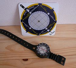
Equipment
Various pieces of equipment have developed to assist divers navigating underwater.- Magnetic compasses, set either in a diver's console or wrist mounted. Various forms exist.
- Scuba sextant, or Nav-finder, to enable a diver to plot an ongoing course during a dive.
- Compass boards
- Hand-held sonar
Periodically reports are issued suggesting the development of underwater GPS
Global Positioning System
The Global Positioning System is a space-based global navigation satellite system that provides location and time information in all weather, anywhere on or near the Earth, where there is an unobstructed line of sight to four or more GPS satellites...
technology, but no system is currently available on market. It is generally thought that the difficulty of locating satellite by signals from underwater at present is not capable of being overcome by existing technology.
Construction
The typical diving compass is made from a card with graduation in degrees, mounted on a pivot in a transparent housing filled with fluid which damps the movement and prevents pressure collapse of the housing. It may be wrist mounted, console mounted or carried some other way. It is desirable that the compass can operate accurately at significant tilt angles without sticking.On the card there is a magnet which will interact with the ambient magnetic field so as to align itself and the card with the field. There will be other marks on the housing which should be aligned with the user, so the offset of the card to the housing will indicate the direction of the magnetic field and the orientation of the user.
Important features of a diving compass are that you can easily read it in dim light, the card or needle does not easily jam if the housing is tilted slightly, and that it can be securely attached to your arm or equipment and does not get lost. It is useful to be able to adjust any straps while wearing gloves, and any clips you may attach should be non-magnetic.
The strap should be long enough to go round your wrist over wet suit or dry suit and glove, and if it is slightly elastic it will stay in place when the suit compresses.
There may be a movable bezel which can be set to record a course and to help set a reciprocal course.
There are also electronic compasses which can provide a digital or analogue display These are based on magnetometer technology.
Direct and Indirect reading compasses
There are two ways in which a compass may be marked, which influence the way you would read them. These are known as Direct reading compasses and Indirect reading compasses. Both provide the same information to the same level of accuracy.The direct reading compass has graduations on the housing which read anti-clockwise round the face, with zero on the far side.
The effect of this configuration is that if the housing is aligned with a direction, the north point of the card or needle will point directly towards the number representing the bearing. No further effort is needed on the part of the operator, you just find the number the arrow points at and read off the bearing.
The bezel has no graduations, it is just a marker to align the card.
The indirect reading compass has graduations on the bezel. These graduations are clockwise round the face, and the zero mark coincides with the notch. To take a bearing the compass must first be aligned with the direction, then the bezel must be turned so that the notch aligns with the north point of the card or needle, and the bearing can then be read at the far side of the compass.
Both types may have graduations on the card which can be read through a side window to give the bearing directly
Sources
- PADIProfessional Association of Diving InstructorsThe Professional Association of Diving Instructors is the world's largest recreational diving membership and diver training organization founded in 1966 by John Cronin and Ralph Erickson...
Underwater Navigation Manual (2003), ISBN 1-878663-15-1