

U.S. Route 40 in Pennsylvania
Encyclopedia
U.S. Route 40 enters Pennsylvania at West Alexander
. It closely parallels I-70 from West Virginia until it reaches Washington
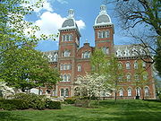
where it follows Jefferson Avenue and Maiden Street. In Washington, US 40 passes to the south of Washington & Jefferson College
. Following Maiden Street out of town, the road turns southeast toward the town of California
. A short limited access highway in California and West Brownsville
provides an approach to the Lane Bane Bridge
across the Monongahela River
. From here, the road continues southeast to Uniontown
.
US 40 bypasses Uniontown along a limited access highway that also carries US 119
. An old alignment through Uniontown is signed as "Business US 40." Southeast of Uniontown, travellers pass the Fort Necessity National Battlefield
. It follows Braddock Road southeast of Uniontown, crossing the Youghiogheny River Lake
on a bridge completed in 2006. US 40 leaves Pennsylvania at Addison
.
 U.S. Route 40 enters Pennsylvania in rural western Washington County
near West Alexander. It travels to the west-northwest paralleling I-70 through Claysville on to Washington. While in Washington, the largest city on U.S. 40 in Pennsylvania, it is named Chestnut St. Exit 15 on I-70/I-79 is signed for Chestnut St. Route 40 leaves Chestnut St. and joins PA 18 becoming Jefferson Ave. After two blocks of concurrency with PA 18, it leaves PA 18 and joins US 19. US 40/US 19 then leaves Washington as Maiden St. US 19 leaves Route 40 in Laboratory before it intersects I-79 again at exit 33. Now heading east-southeast, US 40 makes its way toward Brownsville. Route 40 passes through Scenery Hill and Beallsville before reaching PA 43/PA 88 at a full cloverleaf interchange
in Centerville
. US 40 then crosses the Monongahela River
via the Lane Bane Bridge leaving Washington County after spending nearly 40 miles (64.4 km) in the county.
. When it reaches US 119 it merges with it becoming a bypass
of Uniontown. However, US 40 Business passes through downtown Uniontown as the one-way pair
of Main St. and Fayette St. US 40 travels around the south of Uniontown and meets again with US 40 Business in Hopwood after leaving US 119. Route 40 then begins a steep ascent up the Appalachian Mountains
. US 40 becomes a treacherous mountain highway for the next 10 miles (16.1 km) featuring steep descents and sharp curves. After passing through Chalk Hill, the National Road passes Fort Necessity National Battlefield
and continues to Farmington. On the east side of Farmington, the highway passes Nemacolin Woodlands Resort. The National Pike then continues southeast toward the Maryland border after crossing the Youghiogheny River
and entering Somerset County. Before leaving Pennsylvania, Route 40 passes through Addison. U.S. Route 40 spends 36.5 miles (58.7 km) in Fayette County and 6.1 miles (9.8 km) in Somerset County, passing through its southwestern corner. It enters Maryland
in Garrett County
.
, US 40, or the National Road
was built to connect the East and West. Needed by farmers and emigrants alike, the National Road would provide a stable route for trade through the Allegheny Mountains
. The National Road was preceded by buffalo trails, Native American footpaths, and the Nemacolin Trail. After the Revolutionary War
, and an increase in migration westward, the newly formed national government realized that communication with the west would be difficult with the Appalachian Mountains
separating the east coast from the western frontier. Therefore, the highway was put into Ohio
's statehood bill by Albert Gallatin
in 1802.
In 1806, Thomas Jefferson
authorized the construction of the Cumberland Road—the first federally-funded highway in American history. Construction began in 1811 in Cumberland, Maryland
and was completed to Wheeling, Virginia
(present-day West Virginia
) in 1820. In the 1830s, possession of the highway was turned over to the states through which it passes, which allowed states to collect tolls. The Commonwealth of Pennsylvania construct six tollhouses along its 90-segment of the highway. Two of these still stand: the Petersburg Tollhouse in Addison
and the Searights Tollhouse
in Fayette County. The Petersburg Tollhouse is the only native-cut stone tollhouse still standing in America today. Mile markers were also placed along the route. Made of cast-iron, these obelisk markers were place every one mile and noted the distance to Cumberland and Wheeling and nearby towns. All of these markers are present today, though not all are the originals. Also in the 1830s, the Pony Express
utilized the National Road. The 1840s marked the peak of the National Road. Used by many important figures including presidents, future presidents, and other notables, local businesses saw booming success along the road. This time period gave the National Road its nickname of the nation's "Main Street". The navigation of the Monongahela River
after the construction of several locks and dams gave the National Road access to Pittsburgh via Brownsville. The Baltimore & Ohio Railroad also arrived in Cumberland in the 1840s. This allowed travel from the east coast to Cumberland via train, from Cumberland to Brownsville via stage coach, and then from Brownsville to Pittsburgh via steamboat
. In the 1850s, railroads made it to the west causing the demise of the National Road.
. The invention of the automobile
would truly revitalize the highway. Touring along the National Road was popular and many of the businesses returned to offer services to this new type of consumer. The Post Office Appropriation Act of 1912 and the Rural Road Act of 1916 provide funds to rebuild the National Road, and World War I
and the overburdened railroads make national highways a priority in the early twentieth century. In 1921, the National Road became U.S. Route 40
after the National Highway Act. The Pennsylvania Route 11 designation was also given to the National Road through Pennsylvania, eventually becoming Pennsylvania Route 81 before the road became solely US 40. The road became very popular again in the 1940s, but this only lasted until the 1950s when the Interstate Highway System
was put into place. Today, US 40 has been replaced significantly by Interstate 70
and Interstate 68
. US 40 is still used as a local road and scenic route in Pennsylvania, however. US 40 in Pennsylvania has been designated an All American Road (June 13, 2002), a Pennsylvania State Scenic Byway (July 11, 1996), and the Pennsylvania Heritage Corridor (May, 1994).
Currently, US 40 is undergoing several major changes as the Mon-Fayette Expressway is being constructed. The most notable example occurs just east of Brownsville, where approximately two miles of Route 40 have been moved to a new alignment, which was designed to provide direct access to the Expressway and to one other local road. The new bypass has been named Redstone Way. The former alignment of Route 40 from Market Street to the intersection with Redstone Way near the Brownsville Drive-In has been redesignated as a business loop.
West Alexander, Pennsylvania
West Alexander is an unincorporated community in Washington County, Pennsylvania, United States. The population was 320 at the 2000 census, at which time it was a borough...
. It closely parallels I-70 from West Virginia until it reaches Washington
Washington, Pennsylvania
Washington is a city in and the county seat of Washington County, Pennsylvania, United States, within the Pittsburgh Metro Area in the southwestern part of the state...
where it follows Jefferson Avenue and Maiden Street. In Washington, US 40 passes to the south of Washington & Jefferson College
Washington & Jefferson College
Washington & Jefferson College, also known as W & J College or W&J, is a private liberal arts college in Washington, Pennsylvania, in the United States, which is south of Pittsburgh...
. Following Maiden Street out of town, the road turns southeast toward the town of California
California, Pennsylvania
California is a borough in Washington County, Pennsylvania, United States, along the Monongahela River. The population was 5,274 as of the 2000 census. California is the home of California University of Pennsylvania. Founded in 1849, the borough was named for the territory of California following...
. A short limited access highway in California and West Brownsville
West Brownsville, Pennsylvania
West Brownsville is a borough in Washington County, Pennsylvania, United States. The population was 1,075 at the 2000 census.-Geography:West Brownsville is located at ....
provides an approach to the Lane Bane Bridge
Lane Bane Bridge
The Lane Bane Bridge is a truss bridge that carries vehicular traffic across the Monongahela River between Brownsville, Pennsylvania and West Brownsville, Pennsylvania. The high level bridge was constructed in 1960 and was originally deigned to be part of the Mon-Fayette Expressway...
across the Monongahela River
Monongahela River
The Monongahela River is a river on the Allegheny Plateau in north-central West Virginia and southwestern Pennsylvania in the United States...
. From here, the road continues southeast to Uniontown
Uniontown, Pennsylvania
Uniontown is a city in Fayette County, Pennsylvania, southeast of Pittsburgh and part of the Pittsburgh Metro Area. Population in 1900, 7,344; in 1910, 13,344; in 1920, 15,692; and in 1940, 21,819. The population was 10,372 at the 2010 census...
.
US 40 bypasses Uniontown along a limited access highway that also carries US 119
U.S. Route 119
U.S. Route 119, commonly abbreviated as US 119, is a spur of US 19. It is a north–south route that was an original United States highway of 1926. It is often referred to as Corridor G east of US 23 and KY 80 in Kentucky to Interstate 64 at Charleston, West Virginia.- Kentucky :US 119 is a two...
. An old alignment through Uniontown is signed as "Business US 40." Southeast of Uniontown, travellers pass the Fort Necessity National Battlefield
Fort Necessity National Battlefield
Fort Necessity National Battlefield is a National Battlefield Site in Fayette County, Pennsylvania, United States, which preserves elements of the Battle of Fort Necessity...
. It follows Braddock Road southeast of Uniontown, crossing the Youghiogheny River Lake
Youghiogheny River Lake
The Youghiogheny River Lake is a flood control reservoir in southwestern Pennsylvania and western Maryland. It was formed in 1944 by the damming of the Youghiogheny River upstream from Confluence, Pennsylvania....
on a bridge completed in 2006. US 40 leaves Pennsylvania at Addison
Addison, Pennsylvania
Addison is a borough in Somerset County, Pennsylvania, United States. It is part of the Johnstown, Pennsylvania Metropolitan Statistical Area. The population was 214 at the 2000 census.-Geography:...
.
Washington County
Washington County, Pennsylvania
-Government and politics:As of November 2008, there are 152,534 registered voters in Washington County .* Democratic: 89,027 * Republican: 49,025 * Other Parties: 14,482...
near West Alexander. It travels to the west-northwest paralleling I-70 through Claysville on to Washington. While in Washington, the largest city on U.S. 40 in Pennsylvania, it is named Chestnut St. Exit 15 on I-70/I-79 is signed for Chestnut St. Route 40 leaves Chestnut St. and joins PA 18 becoming Jefferson Ave. After two blocks of concurrency with PA 18, it leaves PA 18 and joins US 19. US 40/US 19 then leaves Washington as Maiden St. US 19 leaves Route 40 in Laboratory before it intersects I-79 again at exit 33. Now heading east-southeast, US 40 makes its way toward Brownsville. Route 40 passes through Scenery Hill and Beallsville before reaching PA 43/PA 88 at a full cloverleaf interchange
Cloverleaf interchange
A cloverleaf interchange is a two-level interchange in which left turns, reverse direction in left-driving regions, are handled by ramp roads...
in Centerville
Centerville, Washington County, Pennsylvania
Centerville is a borough in Washington County, Pennsylvania, United States. The population was 3,390 at the 2000 census.-Geography:Centerville is located at ....
. US 40 then crosses the Monongahela River
Monongahela River
The Monongahela River is a river on the Allegheny Plateau in north-central West Virginia and southwestern Pennsylvania in the United States...
via the Lane Bane Bridge leaving Washington County after spending nearly 40 miles (64.4 km) in the county.
Fayette and Somerset Counties
US 40 enters Fayette County as Market St. in Brownsville. After leaving Brownsville, Route 40 heads to the southeast toward Uniontown. The highway enters Uniontown as Main St. in front of the Uniontown MallUniontown Mall
Uniontown Mall is a regional enclosed shopping mall in South Union Township, Fayette County, Pennsylvania . It is anchored by Sears, Bon-Ton, Burlington Coat Factory, J.C...
. When it reaches US 119 it merges with it becoming a bypass
Bypass (road)
A bypass is a road or highway that avoids or "bypasses" a built-up area, town, or village, to let through traffic flow without interference from local traffic, to reduce congestion in the built-up area, and to improve road safety....
of Uniontown. However, US 40 Business passes through downtown Uniontown as the one-way pair
One-way pair
A one-way pair, one-way couple, or just couplet is a pair of parallel, usually one-way streets that carry opposite directions of a signed route or major traffic flow, or sometimes opposite directions of a bus or streetcar route....
of Main St. and Fayette St. US 40 travels around the south of Uniontown and meets again with US 40 Business in Hopwood after leaving US 119. Route 40 then begins a steep ascent up the Appalachian Mountains
Appalachian Mountains
The Appalachian Mountains #Whether the stressed vowel is or ,#Whether the "ch" is pronounced as a fricative or an affricate , and#Whether the final vowel is the monophthong or the diphthong .), often called the Appalachians, are a system of mountains in eastern North America. The Appalachians...
. US 40 becomes a treacherous mountain highway for the next 10 miles (16.1 km) featuring steep descents and sharp curves. After passing through Chalk Hill, the National Road passes Fort Necessity National Battlefield
Fort Necessity National Battlefield
Fort Necessity National Battlefield is a National Battlefield Site in Fayette County, Pennsylvania, United States, which preserves elements of the Battle of Fort Necessity...
and continues to Farmington. On the east side of Farmington, the highway passes Nemacolin Woodlands Resort. The National Pike then continues southeast toward the Maryland border after crossing the Youghiogheny River
Youghiogheny River
The Youghiogheny River , or the Yough for short, is a tributary of the Monongahela River in the U.S. states of West Virginia, Maryland, and Pennsylvania...
and entering Somerset County. Before leaving Pennsylvania, Route 40 passes through Addison. U.S. Route 40 spends 36.5 miles (58.7 km) in Fayette County and 6.1 miles (9.8 km) in Somerset County, passing through its southwestern corner. It enters Maryland
Maryland
Maryland is a U.S. state located in the Mid Atlantic region of the United States, bordering Virginia, West Virginia, and the District of Columbia to its south and west; Pennsylvania to its north; and Delaware to its east...
in Garrett County
Garrett County, Maryland
Garrett County is the westernmost county of the U.S. state of Maryland. Created from Allegany County, Maryland in 1872 it was the last Maryland county to be formed. It was named for John Work Garrett , railroad executive, industrialist, and financier. Garrett served as president of the Baltimore...
.
1789 to 1860
Envisioned by George WashingtonGeorge Washington
George Washington was the dominant military and political leader of the new United States of America from 1775 to 1799. He led the American victory over Great Britain in the American Revolutionary War as commander-in-chief of the Continental Army from 1775 to 1783, and presided over the writing of...
, US 40, or the National Road
National Road
The National Road or Cumberland Road was the first major improved highway in the United States to be built by the federal government. Construction began heading west in 1811 at Cumberland, Maryland, on the Potomac River. It crossed the Allegheny Mountains and southwestern Pennsylvania, reaching...
was built to connect the East and West. Needed by farmers and emigrants alike, the National Road would provide a stable route for trade through the Allegheny Mountains
Allegheny Mountains
The Allegheny Mountain Range , also spelled Alleghany, Allegany and, informally, the Alleghenies, is part of the vast Appalachian Mountain Range of the eastern United States and Canada...
. The National Road was preceded by buffalo trails, Native American footpaths, and the Nemacolin Trail. After the Revolutionary War
American Revolution
The American Revolution was the political upheaval during the last half of the 18th century in which thirteen colonies in North America joined together to break free from the British Empire, combining to become the United States of America...
, and an increase in migration westward, the newly formed national government realized that communication with the west would be difficult with the Appalachian Mountains
Appalachian Mountains
The Appalachian Mountains #Whether the stressed vowel is or ,#Whether the "ch" is pronounced as a fricative or an affricate , and#Whether the final vowel is the monophthong or the diphthong .), often called the Appalachians, are a system of mountains in eastern North America. The Appalachians...
separating the east coast from the western frontier. Therefore, the highway was put into Ohio
Ohio
Ohio is a Midwestern state in the United States. The 34th largest state by area in the U.S.,it is the 7th‑most populous with over 11.5 million residents, containing several major American cities and seven metropolitan areas with populations of 500,000 or more.The state's capital is Columbus...
's statehood bill by Albert Gallatin
Albert Gallatin
Abraham Alfonse Albert Gallatin was a Swiss-American ethnologist, linguist, politician, diplomat, congressman, and the longest-serving United States Secretary of the Treasury. In 1831, he founded the University of the City of New York...
in 1802.
In 1806, Thomas Jefferson
Thomas Jefferson
Thomas Jefferson was the principal author of the United States Declaration of Independence and the Statute of Virginia for Religious Freedom , the third President of the United States and founder of the University of Virginia...
authorized the construction of the Cumberland Road—the first federally-funded highway in American history. Construction began in 1811 in Cumberland, Maryland
Cumberland, Maryland
Cumberland is a city in the far western, Appalachian portion of Maryland, United States. It is the county seat of Allegany County, and the primary city of the Cumberland, MD-WV Metropolitan Statistical Area. At the 2010 census, the city had a population of 20,859, and the metropolitan area had a...
and was completed to Wheeling, Virginia
Wheeling, West Virginia
Wheeling is a city in Ohio and Marshall counties in the U.S. state of West Virginia; it is the county seat of Ohio County. Wheeling is the principal city of the Wheeling Metropolitan Statistical Area...
(present-day West Virginia
West Virginia
West Virginia is a state in the Appalachian and Southeastern regions of the United States, bordered by Virginia to the southeast, Kentucky to the southwest, Ohio to the northwest, Pennsylvania to the northeast and Maryland to the east...
) in 1820. In the 1830s, possession of the highway was turned over to the states through which it passes, which allowed states to collect tolls. The Commonwealth of Pennsylvania construct six tollhouses along its 90-segment of the highway. Two of these still stand: the Petersburg Tollhouse in Addison
Addison, Pennsylvania
Addison is a borough in Somerset County, Pennsylvania, United States. It is part of the Johnstown, Pennsylvania Metropolitan Statistical Area. The population was 214 at the 2000 census.-Geography:...
and the Searights Tollhouse
Searights Tollhouse, National Road
Searights Tollhouse, National Road is a site near Uniontown, Pennsylvania on the National Road.It was declared a National Historic Landmark in 1964.It is located on United States Route 40 west of Uniontown....
in Fayette County. The Petersburg Tollhouse is the only native-cut stone tollhouse still standing in America today. Mile markers were also placed along the route. Made of cast-iron, these obelisk markers were place every one mile and noted the distance to Cumberland and Wheeling and nearby towns. All of these markers are present today, though not all are the originals. Also in the 1830s, the Pony Express
Pony Express
The Pony Express was a fast mail service crossing the Great Plains, the Rocky Mountains, and the High Sierra from St. Joseph, Missouri, to Sacramento, California, from April 3, 1860 to October 1861...
utilized the National Road. The 1840s marked the peak of the National Road. Used by many important figures including presidents, future presidents, and other notables, local businesses saw booming success along the road. This time period gave the National Road its nickname of the nation's "Main Street". The navigation of the Monongahela River
Monongahela River
The Monongahela River is a river on the Allegheny Plateau in north-central West Virginia and southwestern Pennsylvania in the United States...
after the construction of several locks and dams gave the National Road access to Pittsburgh via Brownsville. The Baltimore & Ohio Railroad also arrived in Cumberland in the 1840s. This allowed travel from the east coast to Cumberland via train, from Cumberland to Brownsville via stage coach, and then from Brownsville to Pittsburgh via steamboat
Steamboat
A steamboat or steamship, sometimes called a steamer, is a ship in which the primary method of propulsion is steam power, typically driving propellers or paddlewheels...
. In the 1850s, railroads made it to the west causing the demise of the National Road.
1860 to present
In the 1860s, the National Road became insignificant due to the use of the railroads. Many businesses along the route became private homes and the stage coach line went out of business. States relinquished responsibility of the highway to the counties so little or no maintenance was performed on the road. The 1880s brought a small revival to the National Road with the formation of the Good Roads MovementGood Roads Movement
The Good Roads Movement occurred in the United States between the late 1870s and the 1920s. Advocates for improved roads led by bicyclists turned local agitation into a national political movement....
. The invention of the automobile
Automobile
An automobile, autocar, motor car or car is a wheeled motor vehicle used for transporting passengers, which also carries its own engine or motor...
would truly revitalize the highway. Touring along the National Road was popular and many of the businesses returned to offer services to this new type of consumer. The Post Office Appropriation Act of 1912 and the Rural Road Act of 1916 provide funds to rebuild the National Road, and World War I
World War I
World War I , which was predominantly called the World War or the Great War from its occurrence until 1939, and the First World War or World War I thereafter, was a major war centred in Europe that began on 28 July 1914 and lasted until 11 November 1918...
and the overburdened railroads make national highways a priority in the early twentieth century. In 1921, the National Road became U.S. Route 40
U.S. Route 40
U.S. Route 40 is an east–west United States highway. As with most routes whose numbers end in a zero, U.S. 40 once traversed the entire United States. It is one of the original 1920s U.S. Highways, and its first termini were San Francisco, California, and Atlantic City, New Jersey...
after the National Highway Act. The Pennsylvania Route 11 designation was also given to the National Road through Pennsylvania, eventually becoming Pennsylvania Route 81 before the road became solely US 40. The road became very popular again in the 1940s, but this only lasted until the 1950s when the Interstate Highway System
Interstate Highway System
The Dwight D. Eisenhower National System of Interstate and Defense Highways, , is a network of limited-access roads including freeways, highways, and expressways forming part of the National Highway System of the United States of America...
was put into place. Today, US 40 has been replaced significantly by Interstate 70
Interstate 70
Interstate 70 is an Interstate Highway in the United States that runs from Interstate 15 near Cove Fort, Utah, to a Park and Ride near Baltimore, Maryland. It was the first Interstate Highway project in the United States. I-70 approximately traces the path of U.S. Route 40 east of the Rocky...
and Interstate 68
Interstate 68
Interstate 68 is a Interstate highway in the U.S. states of West Virginia and Maryland, connecting in Morgantown to in Hancock. is also Corridor E of the Appalachian Development Highway System. From 1965 until the freeway's construction was completed in 1991, it was designated as...
. US 40 is still used as a local road and scenic route in Pennsylvania, however. US 40 in Pennsylvania has been designated an All American Road (June 13, 2002), a Pennsylvania State Scenic Byway (July 11, 1996), and the Pennsylvania Heritage Corridor (May, 1994).
Currently, US 40 is undergoing several major changes as the Mon-Fayette Expressway is being constructed. The most notable example occurs just east of Brownsville, where approximately two miles of Route 40 have been moved to a new alignment, which was designed to provide direct access to the Expressway and to one other local road. The new bypass has been named Redstone Way. The former alignment of Route 40 from Market Street to the intersection with Redstone Way near the Brownsville Drive-In has been redesignated as a business loop.