
Fort Necessity National Battlefield
Encyclopedia
Fort Necessity National Battlefield is a National Battlefield Site in Fayette County
, Pennsylvania
, United States, which preserves elements of the Battle of Fort Necessity. The battle, which took place on July 3, 1754, was an early battle of the French and Indian War
, and resulted in the surrender of the British, under Colonel George Washington
, to the French and Indians, under Louis Coulon de Villiers
.
The site also includes the Mount Washington Tavern, once one of the inns along the National Road
, and in two separate units the grave of the British General Edward Braddock, killed in 1755, and the site of the Battle of Jumonville Glen
.
, Pennsylvania
, George Washington
decided it prudent to reinforce his position. Supposedly named by Washington as Fort Necessity or Fort of Necessity, the soldiers constructed a storehouse for supplies such as gunpowder, rum, and flour. The crude palisade they erected was built more to defend supplies in the fort's storehouse from Washington's own men, whom he described as "loose and idle", than as a planned defense against a hostile enemy. The sutler
of Washington's force was John Fraser, who earlier had been second-in-command at Fort Prince George
. Later he served as Chief Scout to General Edward Braddock
and then Chief Teamster to the Forbes Expedition.
By June 12, 1754, Washington had under his command 293 colonials and the nominal command of 100 additional regular British army troops from South Carolina
. Washington spent the remainder of June 1754 extending the wilderness road further west and down the western slopes of the Allegheny range into the valley of the Monongahela River
. He wanted to create a river crossing point roughly 41 mi (66 km) near Redstone Creek and Redstone Old Fort
. This was a prehistoric Native American
earthwork mound on a bluff overlooking the river crossing. The aboriginal mound structure may have once been part of a fortification. Five years later in the war, Fort Burd was constructed at Redstone Old Fort. The area eventually became the site of Nemacolin Castle and Brownsville, Pennsylvania
an important western jumping-off point for travelers' crossing the Alleghenies in the late 18th and early 19th centuries.
To reach the Ohio River
basins' navigable waters as soon as possible on the Monongahela River
, Washington chose to follow Nemacolin's Trail, an ancient Native American trail which had been somewhat improved by colonists, with Nemacolin's help. He preferred this to following the ridge-hopping, high-altitude path traversed by the western part of Braddock's Road. It jogged to the north near the fort and passed over another notch near Confluence, Pennsylvania
into the valley and drainage basin
of the Youghiogheny River
. The Redstone destination at the terminus of Nemacolin's Trail was a natural choice for an advanced base. The location was one of the few known good crossing points where both sides of the wide deep river had low accessible banks; steep sides were characteristic of the Monongahela River valley.
Late in the day on July 3, Washington did not know the French situation. Believing his situation was impossible, he accepted surrender terms which allowed the peaceful withdrawal of his forces, which he completed on July 4, 1754. The French subsequently occupied the fort and then burned it. Washington did not speak French, and stated later that if he had known that he was confessing to the "assassination" of Joseph Coulon de Jumonville
, he would not have signed the surrender document.
of the 20th century, attempts to preserve the location of Fort Necessity were undertaken. On March 4, 1931, Congress declared the location a National Battlefield Site
under management of the War Department
. Transferred to the National Park Service
in 1933, the park was redesignated a National Battlefield on August 10, 1961. As with all historic sites administered by the National Park Service, the battlefield was listed on the National Register of Historic Places
on October 15, 1966.
Subsequent archaeological research helped to uncover the majority of the original fort position, shape and design. A replica of the fort was constructed on site in the 1970s. A new visitor center
, which also is home to a National Road
interpretive center, opened on October 8, 2005. The battlefield and fort are currently being improved. The fort replica is being reconstructed to look more historically accurate, new informative signs being added, and the historic treelines and charge locations are being outlined.
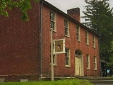
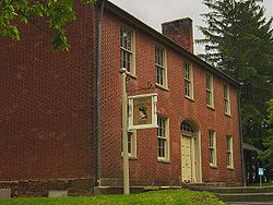 On a hillside adjacent to the battlefield and within the boundaries of the park is Mount Washington Tavern, a classic example of the many inns' once lining the National Road
, the United States' first federally funded highway.
The land on which the tavern was built was originally owned by George Washington. In 1770 he purchased the site on which he had commanded his first battle. Around the 1830s, Judge Nathnial Ewing of Uniontown constructed the tavern. James Sampey acquired the tavern in 1840. It was operated by his family until the railroad construction boom caused the National Road to decline in popularity, rendering the inn unprofitable. In 1855, it was sold to the Fazenbaker family. They used it as a private home for the next 75 years, until the Common Wealth Of Pennsylvania purchased the property in 1932. In 1961 the National Park Service purchase the property from the state, making the building a part of Fort Necessity. The Mount Washington Tavern demonstrates the standard features of an early American tavern, including a simple barroom that served as a gathering place, a more refined parlor that was used for relaxation, and bedrooms in which numerous people would crowd to catch up on sleep.
In a separate unit of the park, lying about one mile (1.6 km) northwest of the battlefield, is the grave of General Edward Braddock
. The legendary British commander oversaw many French and Indian War battles and led the construction of a useful, but inadequate wilderness road through Western Pennsylvania. Braddock was severely wounded in a failed siege on Fort Duquesne
. He and his regiment fled along the wilderness road to a site near Great Meadows. Here, on July 13, 1755, the general died and was buried in an elaborate ceremony officiated by George Washington. His grave was hidden by the British, hoping to keep the site's location out of the hands of the enemy. In 1804 Braddock's remains were discovered by men making repairs to the wilderness road. A fitting marker was erected in 1913.
Fayette County, Pennsylvania
Fayette County is a county located in the U.S. state of Pennsylvania. As of the2010 census, the population was 136,606. The county is part of the Pittsburgh Metropolitan Statistical Area....
, Pennsylvania
Pennsylvania
The Commonwealth of Pennsylvania is a U.S. state that is located in the Northeastern and Mid-Atlantic regions of the United States. The state borders Delaware and Maryland to the south, West Virginia to the southwest, Ohio to the west, New York and Ontario, Canada, to the north, and New Jersey to...
, United States, which preserves elements of the Battle of Fort Necessity. The battle, which took place on July 3, 1754, was an early battle of the French and Indian War
French and Indian War
The French and Indian War is the common American name for the war between Great Britain and France in North America from 1754 to 1763. In 1756, the war erupted into the world-wide conflict known as the Seven Years' War and thus came to be regarded as the North American theater of that war...
, and resulted in the surrender of the British, under Colonel George Washington
George Washington
George Washington was the dominant military and political leader of the new United States of America from 1775 to 1799. He led the American victory over Great Britain in the American Revolutionary War as commander-in-chief of the Continental Army from 1775 to 1783, and presided over the writing of...
, to the French and Indians, under Louis Coulon de Villiers
Louis Coulon de Villiers
Sieur Louis Coulon de Villiers was a French Canadian military officer during the French and Indian War . Perhaps his greatest claim to fame is the fact that he is the only military opponent to force George Washington to surrender.Coulon was born into a prominent French Canadian family...
.
The site also includes the Mount Washington Tavern, once one of the inns along the National Road
National Road
The National Road or Cumberland Road was the first major improved highway in the United States to be built by the federal government. Construction began heading west in 1811 at Cumberland, Maryland, on the Potomac River. It crossed the Allegheny Mountains and southwestern Pennsylvania, reaching...
, and in two separate units the grave of the British General Edward Braddock, killed in 1755, and the site of the Battle of Jumonville Glen
Battle of Jumonville Glen
The Battle of Jumonville Glen, also known as the Jumonville affair, was the opening battle of the French and Indian War fought on May 28, 1754 near what is present-day Uniontown in Fayette County, Pennsylvania...
.
Battle of Fort Necessity
After returning to the great meadows in what is now Fayette CountyFayette County, Pennsylvania
Fayette County is a county located in the U.S. state of Pennsylvania. As of the2010 census, the population was 136,606. The county is part of the Pittsburgh Metropolitan Statistical Area....
, Pennsylvania
Pennsylvania
The Commonwealth of Pennsylvania is a U.S. state that is located in the Northeastern and Mid-Atlantic regions of the United States. The state borders Delaware and Maryland to the south, West Virginia to the southwest, Ohio to the west, New York and Ontario, Canada, to the north, and New Jersey to...
, George Washington
George Washington
George Washington was the dominant military and political leader of the new United States of America from 1775 to 1799. He led the American victory over Great Britain in the American Revolutionary War as commander-in-chief of the Continental Army from 1775 to 1783, and presided over the writing of...
decided it prudent to reinforce his position. Supposedly named by Washington as Fort Necessity or Fort of Necessity, the soldiers constructed a storehouse for supplies such as gunpowder, rum, and flour. The crude palisade they erected was built more to defend supplies in the fort's storehouse from Washington's own men, whom he described as "loose and idle", than as a planned defense against a hostile enemy. The sutler
Sutler
A sutler or victualer is a civilian merchant who sells provisions to an army in the field, in camp or in quarters. The sutler sold wares from the back of a wagon or a temporary tent, allowing them to travel along with an army or to remote military outposts...
of Washington's force was John Fraser, who earlier had been second-in-command at Fort Prince George
Fort Prince George
Fort Prince George was an uncompleted fort on what is now the site of Pittsburgh, at the confluence of the Allegheny and Monongahela Rivers in Allegheny County, Pennsylvania. The site was originally a trading post established by Ohio Company trader William Trent in the 1740s...
. Later he served as Chief Scout to General Edward Braddock
Edward Braddock
General Edward Braddock was a British soldier and commander-in-chief for the 13 colonies during the actions at the start of the French and Indian War...
and then Chief Teamster to the Forbes Expedition.
By June 12, 1754, Washington had under his command 293 colonials and the nominal command of 100 additional regular British army troops from South Carolina
South Carolina
South Carolina is a state in the Deep South of the United States that borders Georgia to the south, North Carolina to the north, and the Atlantic Ocean to the east. Originally part of the Province of Carolina, the Province of South Carolina was one of the 13 colonies that declared independence...
. Washington spent the remainder of June 1754 extending the wilderness road further west and down the western slopes of the Allegheny range into the valley of the Monongahela River
Monongahela River
The Monongahela River is a river on the Allegheny Plateau in north-central West Virginia and southwestern Pennsylvania in the United States...
. He wanted to create a river crossing point roughly 41 mi (66 km) near Redstone Creek and Redstone Old Fort
Redstone Old Fort
Redstone Old Fort or Redstone Fort or Fort Burd on The Nemacolin Trail was the name of the French and Indian War era wooden fort built in 1759 by Pennsylvania Militia Colonel James Burd to guard the ancient Indian trail's river ford on a mound overlooking the eastern shore of the Monongahela River...
. This was a prehistoric Native American
Indigenous peoples of the Americas
The indigenous peoples of the Americas are the pre-Columbian inhabitants of North and South America, their descendants and other ethnic groups who are identified with those peoples. Indigenous peoples are known in Canada as Aboriginal peoples, and in the United States as Native Americans...
earthwork mound on a bluff overlooking the river crossing. The aboriginal mound structure may have once been part of a fortification. Five years later in the war, Fort Burd was constructed at Redstone Old Fort. The area eventually became the site of Nemacolin Castle and Brownsville, Pennsylvania
Brownsville, Pennsylvania
Brownsville is a borough in Fayette County, Pennsylvania, United States, officially founded in 1785 located 35 miles south of Pittsburgh along the Monongahela River...
an important western jumping-off point for travelers' crossing the Alleghenies in the late 18th and early 19th centuries.
To reach the Ohio River
Ohio River
The Ohio River is the largest tributary, by volume, of the Mississippi River. At the confluence, the Ohio is even bigger than the Mississippi and, thus, is hydrologically the main stream of the whole river system, including the Allegheny River further upstream...
basins' navigable waters as soon as possible on the Monongahela River
Monongahela River
The Monongahela River is a river on the Allegheny Plateau in north-central West Virginia and southwestern Pennsylvania in the United States...
, Washington chose to follow Nemacolin's Trail, an ancient Native American trail which had been somewhat improved by colonists, with Nemacolin's help. He preferred this to following the ridge-hopping, high-altitude path traversed by the western part of Braddock's Road. It jogged to the north near the fort and passed over another notch near Confluence, Pennsylvania
Confluence, Pennsylvania
Confluence is a borough in Somerset County, Pennsylvania, United States. It is part of the Johnstown, Pennsylvania Metropolitan Statistical Area. The population was 834 at the 2000 census.-Geography:Confluence is located at ....
into the valley and drainage basin
Drainage basin
A drainage basin is an extent or an area of land where surface water from rain and melting snow or ice converges to a single point, usually the exit of the basin, where the waters join another waterbody, such as a river, lake, reservoir, estuary, wetland, sea, or ocean...
of the Youghiogheny River
Youghiogheny River
The Youghiogheny River , or the Yough for short, is a tributary of the Monongahela River in the U.S. states of West Virginia, Maryland, and Pennsylvania...
. The Redstone destination at the terminus of Nemacolin's Trail was a natural choice for an advanced base. The location was one of the few known good crossing points where both sides of the wide deep river had low accessible banks; steep sides were characteristic of the Monongahela River valley.
Late in the day on July 3, Washington did not know the French situation. Believing his situation was impossible, he accepted surrender terms which allowed the peaceful withdrawal of his forces, which he completed on July 4, 1754. The French subsequently occupied the fort and then burned it. Washington did not speak French, and stated later that if he had known that he was confessing to the "assassination" of Joseph Coulon de Jumonville
Joseph Coulon de Jumonville
Joseph Coulon de Villiers, Sieur de Jumonville was a French Canadian military officer. His defeat and killing at the Battle of Jumonville Glen by forces led by George Washington was one of the sparks igniting the Seven Years' War.- Early life :Jumonville was born in the seigneury of Verchères, New...
, he would not have signed the surrender document.
Park formation and structure
During the Great DepressionGreat Depression
The Great Depression was a severe worldwide economic depression in the decade preceding World War II. The timing of the Great Depression varied across nations, but in most countries it started in about 1929 and lasted until the late 1930s or early 1940s...
of the 20th century, attempts to preserve the location of Fort Necessity were undertaken. On March 4, 1931, Congress declared the location a National Battlefield Site
National Military Park
National Military Park, National Battlefield, National Battlefield Park, and National Battlefield Site are four designations for 24 battle sites preserved by the United States federal government because of their national importance...
under management of the War Department
United States Department of War
The United States Department of War, also called the War Department , was the United States Cabinet department originally responsible for the operation and maintenance of the United States Army...
. Transferred to the National Park Service
National Park Service
The National Park Service is the U.S. federal agency that manages all national parks, many national monuments, and other conservation and historical properties with various title designations...
in 1933, the park was redesignated a National Battlefield on August 10, 1961. As with all historic sites administered by the National Park Service, the battlefield was listed on the National Register of Historic Places
National Register of Historic Places
The National Register of Historic Places is the United States government's official list of districts, sites, buildings, structures, and objects deemed worthy of preservation...
on October 15, 1966.
Subsequent archaeological research helped to uncover the majority of the original fort position, shape and design. A replica of the fort was constructed on site in the 1970s. A new visitor center
Visitor center
A visitor center or centre , visitor information center, tourist information center, is a physical location that provides tourist information to the visitors who tour the place or area locally...
, which also is home to a National Road
National Road
The National Road or Cumberland Road was the first major improved highway in the United States to be built by the federal government. Construction began heading west in 1811 at Cumberland, Maryland, on the Potomac River. It crossed the Allegheny Mountains and southwestern Pennsylvania, reaching...
interpretive center, opened on October 8, 2005. The battlefield and fort are currently being improved. The fort replica is being reconstructed to look more historically accurate, new informative signs being added, and the historic treelines and charge locations are being outlined.
Mount Washington Tavern
National Road
The National Road or Cumberland Road was the first major improved highway in the United States to be built by the federal government. Construction began heading west in 1811 at Cumberland, Maryland, on the Potomac River. It crossed the Allegheny Mountains and southwestern Pennsylvania, reaching...
, the United States' first federally funded highway.
The land on which the tavern was built was originally owned by George Washington. In 1770 he purchased the site on which he had commanded his first battle. Around the 1830s, Judge Nathnial Ewing of Uniontown constructed the tavern. James Sampey acquired the tavern in 1840. It was operated by his family until the railroad construction boom caused the National Road to decline in popularity, rendering the inn unprofitable. In 1855, it was sold to the Fazenbaker family. They used it as a private home for the next 75 years, until the Common Wealth Of Pennsylvania purchased the property in 1932. In 1961 the National Park Service purchase the property from the state, making the building a part of Fort Necessity. The Mount Washington Tavern demonstrates the standard features of an early American tavern, including a simple barroom that served as a gathering place, a more refined parlor that was used for relaxation, and bedrooms in which numerous people would crowd to catch up on sleep.
General Braddock's grave
The grave of General Edward Braddock.In a separate unit of the park, lying about one mile (1.6 km) northwest of the battlefield, is the grave of General Edward Braddock
Edward Braddock
General Edward Braddock was a British soldier and commander-in-chief for the 13 colonies during the actions at the start of the French and Indian War...
. The legendary British commander oversaw many French and Indian War battles and led the construction of a useful, but inadequate wilderness road through Western Pennsylvania. Braddock was severely wounded in a failed siege on Fort Duquesne
Fort Duquesne
Fort Duquesne was a fort established by the French in 1754, at the junction of the Allegheny and Monongahela rivers in what is now downtown Pittsburgh in the state of Pennsylvania....
. He and his regiment fled along the wilderness road to a site near Great Meadows. Here, on July 13, 1755, the general died and was buried in an elaborate ceremony officiated by George Washington. His grave was hidden by the British, hoping to keep the site's location out of the hands of the enemy. In 1804 Braddock's remains were discovered by men making repairs to the wilderness road. A fitting marker was erected in 1913.
See also
- Joseph Coulon de JumonvilleJoseph Coulon de JumonvilleJoseph Coulon de Villiers, Sieur de Jumonville was a French Canadian military officer. His defeat and killing at the Battle of Jumonville Glen by forces led by George Washington was one of the sparks igniting the Seven Years' War.- Early life :Jumonville was born in the seigneury of Verchères, New...
- JumonvilleJumonvilleJumonville is a United Methodist camping and retreat center located in rural Fayette County, Pennsylvania, USA near the town of Hopwood. Jumonville is famous for its 60-foot-tall cross that stands on top of Dunbar's Knob...
- Battle of Jumonville GlenBattle of Jumonville GlenThe Battle of Jumonville Glen, also known as the Jumonville affair, was the opening battle of the French and Indian War fought on May 28, 1754 near what is present-day Uniontown in Fayette County, Pennsylvania...
- Battle of the Great MeadowsBattle of the Great MeadowsThe Battle of Fort Necessity, or the Battle of the Great Meadows took place on July 3, 1754 in what is now the mountaintop hamlet of Farmington in Fayette County, Pennsylvania. The engagement was one of the first battles of the French and Indian War and George Washington's only military surrender...
External links
- Fort Necessity & National Battlefield Education & Interpretive Center, Christopher Chadbourne and Associates, Inc. (Exhibit Design)
- Map links
- Main unit (Fort Necessity): 39°48′54"N 79°35′22"W
- Braddock Grave unit: 39°49′57"N 79°36′4"W
- Jumonville Glen unit: 39°53′15"N 79°38′38"W