

Wilderness Road
Encyclopedia
Kentucky
The Commonwealth of Kentucky is a state located in the East Central United States of America. As classified by the United States Census Bureau, Kentucky is a Southern state, more specifically in the East South Central region. Kentucky is one of four U.S. states constituted as a commonwealth...
from the East. In 1775, Daniel Boone
Daniel Boone
Daniel Boone was an American pioneer, explorer, and frontiersman whose frontier exploits mad']'e him one of the first folk heroes of the United States. Boone is most famous for his exploration and settlement of what is now the Commonwealth of Kentucky, which was then beyond the western borders of...
blazed a trail for the Transylvania Company from Fort Chiswell in Virginia
Virginia
The Commonwealth of Virginia , is a U.S. state on the Atlantic Coast of the Southern United States. Virginia is nicknamed the "Old Dominion" and sometimes the "Mother of Presidents" after the eight U.S. presidents born there...
through the Cumberland Gap
Cumberland Gap
Cumberland Gap is a pass through the Cumberland Mountains region of the Appalachian Mountains, also known as the Cumberland Water Gap, at the juncture of the U.S. states of Tennessee, Kentucky, and Virginia...
into central Kentucky
Central Kentucky
Central Kentucky is sometimes considered the Central and Southern part of the Bluegrass region, the Far Upper Western Eastern Mountain Coal Fields, and the Far Upper Eastern Pennyroyal regions. Its major cities include Lexington and Frankfort. Lexington citizens, especially radio and TV stations...
. It was later lengthened, following Native American
Native Americans in the United States
Native Americans in the United States are the indigenous peoples in North America within the boundaries of the present-day continental United States, parts of Alaska, and the island state of Hawaii. They are composed of numerous, distinct tribes, states, and ethnic groups, many of which survive as...
trails, to reach the Falls of the Ohio at Louisville
Louisville, Kentucky
Louisville is the largest city in the U.S. state of Kentucky, and the county seat of Jefferson County. Since 2003, the city's borders have been coterminous with those of the county because of a city-county merger. The city's population at the 2010 census was 741,096...
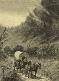
. The Wilderness Road was steep and rough, and it could only be traversed on foot or horseback. Despite the adverse conditions, thousands of people used it.
In 1792, the new Kentucky legislature provided money to upgrade the road. In 1796, an improved all-weather road was opened for wagon and carriage travel. The road was abandoned around 1840, although modern highways follow much of its route.
Early exploration
Europe
Europe is, by convention, one of the world's seven continents. Comprising the westernmost peninsula of Eurasia, Europe is generally 'divided' from Asia to its east by the watershed divides of the Ural and Caucasus Mountains, the Ural River, the Caspian and Black Seas, and the waterways connecting...
an explorers of the southern Appalachian Mountains
Appalachian Mountains
The Appalachian Mountains #Whether the stressed vowel is or ,#Whether the "ch" is pronounced as a fricative or an affricate , and#Whether the final vowel is the monophthong or the diphthong .), often called the Appalachians, are a system of mountains in eastern North America. The Appalachians...
were Spanish
Spain
Spain , officially the Kingdom of Spain languages]] under the European Charter for Regional or Minority Languages. In each of these, Spain's official name is as follows:;;;;;;), is a country and member state of the European Union located in southwestern Europe on the Iberian Peninsula...
. Hernando de Soto
Hernando de Soto (explorer)
Hernando de Soto was a Spanish explorer and conquistador who, while leading the first European expedition deep into the territory of the modern-day United States, was the first European documented to have crossed the Mississippi River....
and his troops traversed the region in 1540 and 1541 searching for gold
Gold
Gold is a chemical element with the symbol Au and an atomic number of 79. Gold is a dense, soft, shiny, malleable and ductile metal. Pure gold has a bright yellow color and luster traditionally considered attractive, which it maintains without oxidizing in air or water. Chemically, gold is a...
. He was followed by several other Spanish expeditions.
The first recorded English
England
England is a country that is part of the United Kingdom. It shares land borders with Scotland to the north and Wales to the west; the Irish Sea is to the north west, the Celtic Sea to the south west, with the North Sea to the east and the English Channel to the south separating it from continental...
explorations of the mountains were those of Abraham Wood
Abraham Wood
Abraham Wood , sometimes referred to as "General" or "Colonel" Wood, was an English fur trader and explorer of 17th century colonial Virginia...
, which began around 1650. Later, Wood sent exploring parties into the mountains. The Batts-Fallam expedition reached the New River Valley
New River Valley
The New River Valley is a region in the eastern United States along the New River in the Commonwealth of Virginia . The valley comprises the counties of Montgomery , Pulaski, Floyd, Giles and the independent City of Radford...
in 1671. In 1673, Wood sent Gabriel Arthur and James Needham to the Overhill Cherokee
Overhill Cherokee
The term Overhill Cherokee refers to the former Cherokee settlements located in what is now Tennessee in the southeastern United States. The name was given by 18th century European traders and explorers who had to cross the Appalachian Mountains to reach these settlements when traveling from...
of modern Tennessee
Tennessee
Tennessee is a U.S. state located in the Southeastern United States. It has a population of 6,346,105, making it the nation's 17th-largest state by population, and covers , making it the 36th-largest by total land area...
. The purpose was to try to make direct contact with the Cherokee
Cherokee
The Cherokee are a Native American people historically settled in the Southeastern United States . Linguistically, they are part of the Iroquoian language family...
for trade, so as to bypass the Ocaneechee "middlemen" traders. The expedition did reach the Overhill Cherokee area, but Needham was killed on the return. Gabriel Arthur was almost killed, but was rescued by being adopted by a Cherokee chief. For his own safety, Arthur was then sent with one of the chief's raiding parties. For about a year, he traveled with the Cherokee, throughout the Appalachians. He was probably the first European to visit modern West Virginia
West Virginia
West Virginia is a state in the Appalachian and Southeastern regions of the United States, bordered by Virginia to the southeast, Kentucky to the southwest, Ohio to the northwest, Pennsylvania to the northeast and Maryland to the east...
and cross the Cumberland Gap.
In 1750, Dr. Thomas Walker
Thomas Walker (explorer)
Dr. Thomas Walker was a physician and explorer from Virginia who led an expedition to what is now the region beyond the Allegheny Mountains area of British North America in the mid-18th century...
, an investor in the Loyal Land Company, with five companions, made a famous exploration through the Cumberland Gap and into eastern Kentucky. The Loyal Land Company settled people in southwest Virginia, but not Kentucky.
In 1769, Virginia longhunter
Longhunter
A Longhunter was an 18th-century explorer and hunter who made expeditions into the American frontier wilderness for as much as six months at a time...
and explorer Joseph Martin
Joseph Martin (general)
Joseph Martin was a brigadier general in the Virginia militia during the American Revolutionary War, in which Martin's frontier diplomacy with the Cherokee people is credited with averting Indian attacks on the Scotch-Irish settlers who helped win the battles of Kings Mountain and Cowpens...
made the first of several forays into the region. Acting as an agent for Dr. Thomas Walker, to whom Martin was connected through family relationships, Martin began an expedition to Powell's Valley in early 1769 in return for a promised 21000 acres (8,498.4 ha) land grant from Walker and the Loyal Land Company. Martin and his men built the earliest westernmost frontier fort at present-day Rose Hill, Virginia
Rose Hill, Lee County, Virginia
Rose Hill is a census-designated place in Lee County, Virginia, United States. The population was 714 at the 2000 census.-Geography:Rose Hill is located at ....
, a fort dubbed Martin's Station. Later that year Indians chased off Martin and his men, who returned to Albemarle County
Albemarle County, Virginia
As of the census of 2000, there were 79,236 people, 31,876 households, and 21,070 families residing in the county. The population density was 110 people per square mile . There were 33,720 housing units at an average density of 47 per square mile...
. Martin returned six years later to rebuild the fort, and a few months later became an agent for Richard Henderson's Transylvania Company.
In 1774, Richard Henderson
Richard Henderson (American pioneer)
Richard Henderson was an American pioneer and merchant who attempted to create a colony called Transylvania just as the American Revolutionary War was starting.-Early life:Henderson was born in Hanover County, Virginia...
, a judge from North Carolina
North Carolina
North Carolina is a state located in the southeastern United States. The state borders South Carolina and Georgia to the south, Tennessee to the west and Virginia to the north. North Carolina contains 100 counties. Its capital is Raleigh, and its largest city is Charlotte...
, organized a land speculation company with a number of other prominent North Carolinians called the Transylvania Company. The men hoped to purchase land from the Cherokees on the Kentucky side of the Appalachian Mountains and establish a British proprietary colony. Henderson hired Daniel Boone, an experienced hunter who had explored Kentucky, to blaze a trail through the Cumberland Gap into central Kentucky.
Boone, the trailblazer
The Appalachian Mountains form a natural barrier to east–west travel, from PennsylvaniaPennsylvania
The Commonwealth of Pennsylvania is a U.S. state that is located in the Northeastern and Mid-Atlantic regions of the United States. The state borders Delaware and Maryland to the south, West Virginia to the southwest, Ohio to the west, New York and Ontario, Canada, to the north, and New Jersey to...
to Georgia
Georgia (U.S. state)
Georgia is a state located in the southeastern United States. It was established in 1732, the last of the original Thirteen Colonies. The state is named after King George II of Great Britain. Georgia was the fourth state to ratify the United States Constitution, on January 2, 1788...
. Settlers from Pennsylvania tended to migrate south along the Great Wagon Road
Great Wagon Road
The Great Wagon Road was a colonial American improved trail transiting the Great Appalachian Valley from Pennsylvania to North Carolina, and from there to Georgia....
through the Great Appalachian Valley
Great Appalachian Valley
The Great Valley, also called the Great Appalachian Valley or Great Valley Region, is one of the major landform features of eastern North America. It is a gigantic trough — a chain of valley lowlands — and the central feature of the Appalachian Mountain system...
and Shenandoah Valley
Shenandoah Valley
The Shenandoah Valley is both a geographic valley and cultural region of western Virginia and West Virginia in the United States. The valley is bounded to the east by the Blue Ridge Mountains, to the west by the eastern front of the Ridge-and-Valley Appalachians , to the north by the Potomac River...
. Daniel Boone was from Pennsylvania and migrated south with his family along this road. From an early age, Boone was one of the longhunter
Longhunter
A Longhunter was an 18th-century explorer and hunter who made expeditions into the American frontier wilderness for as much as six months at a time...
s who hunted and trapped among the Native American nations along the western frontiers of Virginia, so-called because of the long time they spent away from home on hunts in the wilderness. Boone would sometimes be gone for months and even years before returning home from his hunting expeditions.

Salt
In chemistry, salts are ionic compounds that result from the neutralization reaction of an acid and a base. They are composed of cations and anions so that the product is electrically neutral...
. Before 1776, it had to be shipped into the Thirteen Colonies from the West Indies at great expense. It was the only meat preservative available for men on the move and Kentucky had an extra lure with its large salt brine lakes near what is today the community of Boonesborough, Kentucky
Boonesborough, Kentucky
Boonesborough is an unincorporated community in Madison County, Kentucky, United States. It lies in the central part of the state along the Kentucky River. Boonesborough is part of the Richmond–Berea Micropolitan Statistical Area....
.
The many "salt lick
Salt lick
A mineral lick is a natural mineral deposit where animals in nutrient-poor ecosystems can obtain essential mineral nutrients...
s" of Kentucky are today reflected in the many place names in the state that use the words "lick" or "licking".
Starting on March 10, 1775 Boone, along with 35 axmen, cut a trail from Long Island in Kingsport, Tennessee through the forests and mountains to Kentucky. It was a rough mud trail, hardly more than a path. Although the Transylvania Company had obtained title to Kentucky from the Cherokee and Iroquois
Iroquois
The Iroquois , also known as the Haudenosaunee or the "People of the Longhouse", are an association of several tribes of indigenous people of North America...
, they had not from the Shawnee
Shawnee
The Shawnee, Shaawanwaki, Shaawanooki and Shaawanowi lenaweeki, are an Algonquian-speaking people native to North America. Historically they inhabited the areas of Ohio, Virginia, West Virginia, Western Maryland, Kentucky, Indiana, and Pennsylvania...
, who lived and hunted in Kentucky, claimed it, and viewed Boone and other settlers as invaders. On March 24, 1775 Boone and his party were only 15 miles (24 km) from their final destination of the Kentucky River
Kentucky River
The Kentucky River is a tributary of the Ohio River, long, in the U.S. state of Kentucky. The river and its tributaries drain much of the central region of the state, with its upper course passing through the coal-mining regions of the Cumberland Mountains, and its lower course passing through the...
when they camped for the night. Just before daybreak a group of Shawnee, slinging tomahawks
Tomahawk (axe)
A tomahawk is a type of axe native to North America, traditionally resembling a hatchet with a straight shaft. The name came into the English language in the 17th century as a transliteration of the Powhatan word.Tomahawks were general purpose tools used by Native Americans and European Colonials...
, attacked the sleeping men. Some of Boone's party were killed and a few were wounded but most were able to escape into the woods. Boone regrouped his men and managed to drive off the hostile Shawnee. The party did, however, lose some of their horses. Here Boone built a temporary open barricade with 6 to 7 feet (2.1 m) high logs.
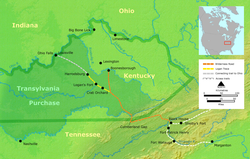
Route
The route of the Wilderness Road made a long loop from Virginia southward to Tennessee and then northward to Kentucky, a distance of 200 miles (321.9 km).From The Long Island of the Holston River (modern Kingsport, Tennessee
Kingsport, Tennessee
Kingsport is a city located mainly in Sullivan County with some western portions in Hawkins County in the US state of Tennessee. The majority of the city lies in Sullivan County...
), the road went north through Moccasin Gap
Moccasin Gap
Moccasin Gap is a gap in Clinch Mountain near Gate City, Virginia, United States, the county seat of Scott County.Daniel Boone's Wilderness Road once traveled through the gap, on its way north from the Long Island of the Holston River, located to the south in Tennessee, towards the well-known...
of Clinch Mountain
Clinch Mountain
Clinch Mountain is a mountain ridge in the U.S. states of Tennessee and Virginia, lying in the ridge-and-valley section of the Appalachian Mountains...
, then crossed the Clinch River
Clinch River
The Clinch River rises in Southwest Virginia near Tazewell, Virginia and flows southwest through the Great Appalachian Valley, gathering various tributaries including the Powell River before joining the Tennessee River in East Tennessee.-Course:...
and crossed rough land (called the Devils Raceway) to the North Fork Clinch River. Then it crossed Powell Mountain
Powell Mountain (Virginia)
Powell Mountain is a mountain ridge of the Ridge-and-valley Appalachians of the Appalachian Mountains. It is a long and narrow ridge, running northeast to southwest, from about Norton, Virginia to near Tazewell, Tennessee...
at Kanes Gap. From there it ran southwest through the valley of the Powell River
Powell River (Virginia)
The Powell River in the United States rises in southwest Virginia and flows into East Tennessee.The river rises in rural Wise County, Virginia near the Laurel Grove community northwest of Norton and flows for several miles before the confluence with Roaring Fork in the Kent Junction community...
to the Cumberland Gap.
After passing over the Cumberland Gap the Wilderness Road forked. The southern fork passed over the Cumberland Plateau
Cumberland Plateau
The Cumberland Plateau is the southern part of the Appalachian Plateau. It includes much of eastern Kentucky and western West Virginia, part of Tennessee, and a small portion of northern Alabama and northwest Georgia . The terms "Allegheny Plateau" and the "Cumberland Plateau" both refer to the...
to Nashville, Tennessee
Nashville, Tennessee
Nashville is the capital of the U.S. state of Tennessee and the county seat of Davidson County. It is located on the Cumberland River in Davidson County, in the north-central part of the state. The city is a center for the health care, publishing, banking and transportation industries, and is home...
via the Cumberland River
Cumberland River
The Cumberland River is a waterway in the Southern United States. It is long. It starts in Harlan County in far southeastern Kentucky between Pine and Cumberland mountains, flows through southern Kentucky, crosses into northern Tennessee, and then curves back up into western Kentucky before...
. The northern fork split into two parts. The eastern spur went into the Bluegrass region
Bluegrass region
The Bluegrass Region is a geographic region in the state of Kentucky, United States. It occupies the northern part of the state and since European settlement has contained a majority of the state's population and its largest cities....
of Kentucky to Boonesborough on the Kentucky River (near Lexington
Lexington, Kentucky
Lexington is the second-largest city in Kentucky and the 63rd largest in the US. Known as the "Thoroughbred City" and the "Horse Capital of the World", it is located in the heart of Kentucky's Bluegrass region...
). The western spur ran to the Falls of the Ohio (Louisville
Louisville, Kentucky
Louisville is the largest city in the U.S. state of Kentucky, and the county seat of Jefferson County. Since 2003, the city's borders have been coterminous with those of the county because of a city-county merger. The city's population at the 2010 census was 741,096...
). As settlements grew southward, the road stretched all the way to Knoxville, Tennessee
Knoxville, Tennessee
Founded in 1786, Knoxville is the third-largest city in the U.S. state of Tennessee, U.S.A., behind Memphis and Nashville, and is the county seat of Knox County. It is the largest city in East Tennessee, and the second-largest city in the Appalachia region...
, by 1792.
Dangers
Because of the threat of Native American attacks, the road was so dangerous that most pioneers traveled well armed. Robbers and criminals also could be found on the road, ready to pounce on weaker pioneers. Although the Transylvania Company had purchased the region from the Cherokee, and the Iroquois
Iroquois
The Iroquois , also known as the Haudenosaunee or the "People of the Longhouse", are an association of several tribes of indigenous people of North America...
had ceded it at the Treaty of Fort Stanwix
Treaty of Fort Stanwix
The Treaty of Fort Stanwix was an important treaty between North American Indians and the British Empire. It was signed in 1768 at Fort Stanwix, located in present-day Rome, New York...
, other tribes, such as the Shawnee, still claimed it and lived there.
Often entire communities and church congregations would move together over the road to new settlements. Hundreds of pioneers were killed by Indian attacks.
Defensive log blockhouses built alongside the road had portholes in the walls for firing at Native American attackers. They were often called "stations". No one knew exactly when the next attack would happen. The Shawnee came from the north, while the Chickamauaga (Cherokees who rejected the land sale treaty) came from the south. The tribes were resentful of the settlers taking their ancestral hunting lands, and the French and Indian War
French and Indian War
The French and Indian War is the common American name for the war between Great Britain and France in North America from 1754 to 1763. In 1756, the war erupted into the world-wide conflict known as the Seven Years' War and thus came to be regarded as the North American theater of that war...
had further stirred up their passions against the white man.
The Scots-Irish were great fighters. They had lived in Ulster
Ulster
Ulster is one of the four provinces of Ireland, located in the north of the island. In ancient Ireland, it was one of the fifths ruled by a "king of over-kings" . Following the Norman invasion of Ireland, the ancient kingdoms were shired into a number of counties for administrative and judicial...
, an English colony in Northern Ireland
Ireland
Ireland is an island to the northwest of continental Europe. It is the third-largest island in Europe and the twentieth-largest island on Earth...
, for a hundred years before coming to America. They had taken over land previously owned by the Irish and had much experience as fighters in defending their homeland.
There was a great variety of animal life in the wilderness. At night, the pioneers could hear the hoots and screeches of owls
OWLS
OWLS is a mnemonic used by general aviation airplane pilots to assess an unprepared surface for a precautionary landing.Like all mnemonics this check has become part of aviation culture and folklore.OWLS:* Obstacles* Wind direction...
, the howls of wolves
Gray Wolf
The gray wolf , also known as the wolf, is the largest extant wild member of the Canidae family...
, and the cries of panthers and wild cats. Sometimes the Native Americans imitated these sounds. Poisonous snakes such as copperheads
Agkistrodon contortrix
Agkistrodon contortrix is a species of venomous snake found in North America, a member of the Crotalinae subfamily. The more common name for the species is "copperhead". The behavior of Agkistrodon contortrix may lead to accidental encounters with humans...
and rattlesnake
Rattlesnake
Rattlesnakes are a group of venomous snakes of the genera Crotalus and Sistrurus of the subfamily Crotalinae . There are 32 known species of rattlesnake, with between 65-70 subspecies, all native to the Americas, ranging from southern Alberta and southern British Columbia in Canada to Central...
s blended into the leaves and undergrowth which were a danger to the pioneers, their horses and cattle.
Settlement
Judge Richard Henderson had made a treaty with the Cherokee at Sycamore ShoalsSycamore Shoals
The Sycamore Shoals of the Watauga River, usually shortened to Sycamore Shoals, is a rocky stretch of river rapids along the Watauga River in Elizabethton, in the U.S. state of Tennessee...
in 1775, purchasing over 20000000 acres (8,093,720 ha) of land between the Cumberland and Kentucky Rivers. On March 28, 1775, he left Long Island (Kingsport, Tennessee) with about 30 horsemen on the grueling trip down the Wilderness Road to Kentucky. At Martin's Station 40 to 50 additional pioneers joined the venture. On their way, they met nearly a hundred refugees fleeing Native American attacks further down the road. Despite the danger, the party kept going toward Kentucky. Since some of the streams were flooded, the pioneers had to swim with their horses. On April 20, they arrived at Boonesborough, a fortified town, named by Judge Henderson in honor of Boone.
After 1770, a surge of over 400,000 Scots-Irish immigrants arrived in the colonies to escape the poor harvest, high rents and religious intolerance of Ulster. Since the better lands had already been taken, they constantly pressed onward to the western frontier of the foothills of the Carolinas.
The flood of Scots-Irish, German, and others immigrants kept coming. Over 200,000 pioneers came over the Wilderness Road, enduring severe hardships. In the winter of 1778-79, the weather was so cold that the Kentucky River froze to a depth of two feet. The frontier settlements alongside the road struggled to survive. Many of the cattle and hogs froze to death. The settlers had to eat frozen cattle and horses to survive.
Often the Chickamauga, under the leadership of Dragging Canoe
Dragging Canoe
Tsiyu Gansini , "He is dragging his canoe", known to whites as Dragging Canoe, was a Cherokee war chief who led a band of Cherokee against colonists and United States settlers...
, would hide in ambush for weeks between Cumberland Gap and Crab Orchard
Crab Orchard, Kentucky
Crab Orchard is a city in Lincoln County, Kentucky, United States. The population was 842 at the 2000 census. It is part of the Danville Micropolitan Statistical Area.-History:...
, a distance of 100 miles (160.9 km). They would not attack large groups but wait for weaker ones who were not able to defend themselves. More than 100 men, women and children were killed in the fall of 1784 along the Wilderness Road. Many families, even in ice and snow, crossed the creeks and rivers without shoes or stockings; they often had no money and few clothes. They lived off the land by hunting in the woods and by fishing in the streams.
Since they had hardly any money, entire families sometimes walked hundreds of miles after landing in America. They even used cattle
Cattle
Cattle are the most common type of large domesticated ungulates. They are a prominent modern member of the subfamily Bovinae, are the most widespread species of the genus Bos, and are most commonly classified collectively as Bos primigenius...
as pack animals to carry their heavy loads. Cabins were built and land was cleared of trees and undergrowth so crops could be planted.
Chestnut
Chestnut
Chestnut , some species called chinkapin or chinquapin, is a genus of eight or nine species of deciduous trees and shrubs in the beech family Fagaceae, native to temperate regions of the Northern Hemisphere. The name also refers to the edible nuts they produce.-Species:The chestnut belongs to the...
was the most popular wood since its logs could be used to build cabins and rail fences to protect crops from wild animals. It could easily be split into shingles for roofs to cover cabins and barns. Its bark was used to make medicine and tannic acid
Tannic acid
Tannic acid is a specific commercial form of tannin, a type of polyphenol. Its weak acidity is due to the numerous phenol groups in the structure...
for tanning and dyeing. In the fall, its rich nuts were used to fatten razorback hogs for the market and the home. Hemlock
Tsuga
Tsuga is a genus of conifers in the family Pinaceae. The common name hemlock is derived from a perceived similarity in the smell of its crushed foliage to that of the unrelated plant poison hemlock....
was also highly valued for its many uses.
Commerce and mail
The Wilderness Road served as a great path of commerce for the early settlers in Kentucky. Horses, cattle, sheep and hogs found a waiting market in the Carolinas, MarylandMaryland
Maryland is a U.S. state located in the Mid Atlantic region of the United States, bordering Virginia, West Virginia, and the District of Columbia to its south and west; Pennsylvania to its north; and Delaware to its east...
and Virginia. Hogs in groups of 500 or more were driven down the Road to market. Beef in Eastern markets had become a main source of income for farmers in Kentucky.
A postal road was opened in 1792 from Bean Station, Tennessee
Bean Station, Tennessee
Bean Station is a city in Grainger County, Tennessee, United States. It is part of the Morristown, Tennessee Metropolitan Statistical Area. The city was incorporated in November 1996...
through Cumberland Gap to Danville, Kentucky
Danville, Kentucky
Danville is a city in and the county seat of Boyle County, Kentucky, United States. The population was 16,218 at the 2010 census.Danville is the principal city of the Danville Micropolitan Statistical Area, which includes all of Boyle and Lincoln counties....
. This was due largely to the efforts of Governor Isaac Shelby
Isaac Shelby
Isaac Shelby was the first and fifth Governor of the U.S. state of Kentucky and served in the state legislatures of Virginia and North Carolina. He was also a soldier in Lord Dunmore's War, the Revolutionary War, and the War of 1812...
of Kentucky. This connection of Kentucky to the East was a great advantage. Frontier settlers considered the postal riders heroes and waited eagerly for their arrival for news from settlements along the trails as well as getting their mail and newspapers.
Civil War and decline
Use of the Wilderness Road fell when the National RoadNational Road
The National Road or Cumberland Road was the first major improved highway in the United States to be built by the federal government. Construction began heading west in 1811 at Cumberland, Maryland, on the Potomac River. It crossed the Allegheny Mountains and southwestern Pennsylvania, reaching...
was opened in 1818, allowing travel to the Ohio River
Ohio River
The Ohio River is the largest tributary, by volume, of the Mississippi River. At the confluence, the Ohio is even bigger than the Mississippi and, thus, is hydrologically the main stream of the whole river system, including the Allegheny River further upstream...
on level ground from the East. At the same time, the steamboat
Steamboat
A steamboat or steamship, sometimes called a steamer, is a ship in which the primary method of propulsion is steam power, typically driving propellers or paddlewheels...
first appeared on the Ohio and Mississippi River
Mississippi River
The Mississippi River is the largest river system in North America. Flowing entirely in the United States, this river rises in western Minnesota and meanders slowly southwards for to the Mississippi River Delta at the Gulf of Mexico. With its many tributaries, the Mississippi's watershed drains...
s, allowing travel both up and down the rivers. (Hitchcock, 85)
During the American Civil War
American Civil War
The American Civil War was a civil war fought in the United States of America. In response to the election of Abraham Lincoln as President of the United States, 11 southern slave states declared their secession from the United States and formed the Confederate States of America ; the other 25...
, both the Union Army
Union Army
The Union Army was the land force that fought for the Union during the American Civil War. It was also known as the Federal Army, the U.S. Army, the Northern Army and the National Army...
and the Confederate States Army
Confederate States Army
The Confederate States Army was the army of the Confederate States of America while the Confederacy existed during the American Civil War. On February 8, 1861, delegates from the seven Deep South states which had already declared their secession from the United States of America adopted the...
used the Road. An early battle (Camp Wildcat
Battle of Camp Wildcat
The Battle of Camp Wildcat was one of the early engagements of the American Civil War. It occurred October 21, 1861, in northern Laurel County, Kentucky during the campaign known as the Kentucky Confederate Offensive...
), stymied the first attempt by the Confederates to seize control of neutral Kentucky. The Cumberland Gap changed hands four times throughout the war. The southern armies used the road for marches into Virginia. General Ulysses S. Grant
Ulysses S. Grant
Ulysses S. Grant was the 18th President of the United States as well as military commander during the Civil War and post-war Reconstruction periods. Under Grant's command, the Union Army defeated the Confederate military and ended the Confederate States of America...
came down the road for the Union campaign in Tennessee in 1864. Grant was so taken by the Road that he said, "With two brigades of the Army of the Cumberland
Army of the Cumberland
The Army of the Cumberland was one of the principal Union armies in the Western Theater during the American Civil War. It was originally known as the Army of the Ohio.-History:...
I could hold that pass against the army which Napoleon
Napoleon I of France
Napoleon Bonaparte was a French military and political leader during the latter stages of the French Revolution.As Napoleon I, he was Emperor of the French from 1804 to 1815...
led to Moscow."
The road today
A segment of the Wilderness Road was among the first roads in the United States to be paved. The old road from the town of Cumberland Gap, Tennessee to Middlesboro, Kentucky through the mountain pass was paved and completed on October 3, 1908. This was an "object-lesson" road (a new kind of paved macadam construction funded by local communities but with federal governmental supervision) initiated by the U.S. Office of Public Roads. At that time, only about 680 miles (1,094.4 km) of paved roads existed in the United StatesUnited States
The United States of America is a federal constitutional republic comprising fifty states and a federal district...
. Later, it was linked to the famous Dixie Highway
Dixie Highway
The Dixie Highway was a United States automobile highway, first planned in 1914 to connect the US Midwest with the Southern United States. It was part of the National Auto Trail system, and grew out of an earlier Miami to Montreal highway. The final result is better understood as a small network of...
that connected Detroit, Michigan
Detroit, Michigan
Detroit is the major city among the primary cultural, financial, and transportation centers in the Metro Detroit area, a region of 5.2 million people. As the seat of Wayne County, the city of Detroit is the largest city in the U.S. state of Michigan and serves as a major port on the Detroit River...
to Miami, Florida
Miami, Florida
Miami is a city located on the Atlantic coast in southeastern Florida and the county seat of Miami-Dade County, the most populous county in Florida and the eighth-most populous county in the United States with a population of 2,500,625...
by a paved road. Its name was later changed to U.S. Highway 25
U.S. Route 25
U.S. Route 25 is a north–south United States highway that runs for from Brunswick, Georgia to the Ohio state line in Covington, Kentucky.-Georgia:...
. This new road brought a new industry, tourism, to the rural areas filling hotels and restaurants with travelers.
Today, Cumberland Gap is a National Park
Cumberland Gap National Historical Park
Established on June 11, 1940, Cumberland Gap National Historical Park is a United States National Historical Park located at the border between Kentucky, Tennessee, and Virginia. The Cumberland Gap is a sizable natural break in the Appalachian Mountains....
, and portions of the Wilderness Road can be visited at Wilderness Road State Park
Wilderness Road State Park
Wilderness Road State Park is a state park located in southwestern Virginia, near Cumberland Gap and Ewing, VA. It consists of about around the former Wilderness Road.Within it stand the Karlan Mansion and a replica of the original Martin's Station fort....
in Virginia. Additionally, a reconstructed fort at Martin’s Station in Virginia on the Wilderness Road can be visited about 5 miles (8 km) east of the Cumberland Gap. Since the completion of the Cumberland Gap Tunnel
Cumberland Gap Tunnel
The Cumberland Gap Tunnel is a tunnel that carries U.S. Route 25E under Cumberland Gap National Historical Park near the intersection of Kentucky, Tennessee, and Virginia. The east portal of the tunnel is in Tennessee and the west portal is in Kentucky; according to United States Geological Survey...
in 1996, a project has been underway to restore the original appearance of the Wilderness Road as it crosses the historic Cumberland Gap. Since 2001 Hwy. 25E has been obliterated over several miles of its length and the original grade restored, including the addition of 32 feet (9.8 m) of elevation to restore the Gap to its original contour, with virtually all modern artifacts, buildings and roads removed. The replanting of thousands of seedlings from original forest stocks in the area is intended, over a period of decades, to recreate a forest that will allow visitors to view the crossing of the Gap on the Wilderness Road as travelers would have experienced it circa 1790. This section of the Wilderness Road is now a hiking trail, including an interpretive center about the road's history located on the Tennessee side.