
Hogg Rock
Encyclopedia
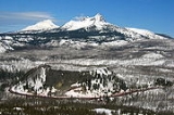
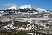
Hogg Rock is a tuya
volcano
in the Cascade Range
of northern Oregon
, located west of Santiam Pass
beside the Santiam Highway (U.S. Route 20 / Oregon Route 126). The highway wraps in a nearly 180-degree curve below cliffs on the south and west sides.
Hogg Rock is only about 2 miles (3 km) north of Hayrick Butte
, a somewhat larger tuya of similar age and composition. A tuya is a type of subglacial volcano
, formed when lava erupts underneath an overlying glacier
or ice sheet
and then melts through to the surface and pools, producing the flat plateau on top with near-vertical walls along the ice-contact margin as the lava cools and hardens. Unlike most tuyas which have steep cliffs on all sides, Hogg Rock has a break in its cliffs on the east side, with a moderate slope which leads down to a small road and gravel pit
.
 Hogg Rock was named after Colonel T. Egenton Hogg, the promoter of a railroad—Oregon Pacific Railroad
—that was supposed to cross the Cascades in this location.
His railroad was based at Corvallis
and became known as the Oregon Pacific Railroad (not to be confused with the current railroad of that name). His plan called for a railroad from Yaquina Bay
on the Oregon Coast
to Idaho
via Corvallis and Santiam Pass. By the end of 1884, he completed the rail into Corvallis from the coast and reached Albany
by 1886. He then worked up the North Santiam River
and completed trackage as far as Idanha
before running out of money in 1890. In a final desperate effort to claim the pass for his railroad, he laid rails over Santiam Pass near Hogg Rock and pulled a box car back and forth on them to lay a claim to rail service there in 1890. Hogg went bankrupt and E. H. Harriman
of the Southern Pacific Railroad
gained control of the line in 1907. The trackage east of Mill City
was abandoned when Detroit Dam
and Big Cliff Dam were built in 1950, and the dreams of a trans-Oregon railroad terminating at Corvallis was gone.
Tuya
A tuya is a type of distinctive, flat-topped, steep-sided volcano formed when lava erupts through a thick glacier or ice sheet. They are somewhat rare worldwide, being confined to regions which were covered by glaciers and also had active volcanism during the same time period.-Formation:Tuyas are...
volcano
Volcano
2. Bedrock3. Conduit 4. Base5. Sill6. Dike7. Layers of ash emitted by the volcano8. Flank| 9. Layers of lava emitted by the volcano10. Throat11. Parasitic cone12. Lava flow13. Vent14. Crater15...
in the Cascade Range
Cascade Range
The Cascade Range is a major mountain range of western North America, extending from southern British Columbia through Washington and Oregon to Northern California. It includes both non-volcanic mountains, such as the North Cascades, and the notable volcanoes known as the High Cascades...
of northern Oregon
Oregon
Oregon is a state in the Pacific Northwest region of the United States. It is located on the Pacific coast, with Washington to the north, California to the south, Nevada on the southeast and Idaho to the east. The Columbia and Snake rivers delineate much of Oregon's northern and eastern...
, located west of Santiam Pass
Santiam Pass
Santiam Pass is a mountain pass in the Cascade Range in central Oregon in the United States. It is located on the border between Linn and Jefferson counties, about northwest of Sisters, between the prominent volcanic horns of Three Fingered Jack to the north and Mount Washington to the south...
beside the Santiam Highway (U.S. Route 20 / Oregon Route 126). The highway wraps in a nearly 180-degree curve below cliffs on the south and west sides.
Hogg Rock is only about 2 miles (3 km) north of Hayrick Butte
Hayrick Butte
Hayrick Butte is a tuya volcano in the Cascade Range of northern Oregon, located near Santiam Pass just west of the Cascade Crest. It is adjacent to the cinder cone, Hoodoo Butte, which overlaps its western edge....
, a somewhat larger tuya of similar age and composition. A tuya is a type of subglacial volcano
Subglacial volcano
A subglacial volcano, also known as a glaciovolcano, is a volcanic form produced by subglacial eruptions or eruptions beneath the surface of a glacier or ice sheet which is then melted into a lake by the rising lava...
, formed when lava erupts underneath an overlying glacier
Glacier
A glacier is a large persistent body of ice that forms where the accumulation of snow exceeds its ablation over many years, often centuries. At least 0.1 km² in area and 50 m thick, but often much larger, a glacier slowly deforms and flows due to stresses induced by its weight...
or ice sheet
Ice sheet
An ice sheet is a mass of glacier ice that covers surrounding terrain and is greater than 50,000 km² , thus also known as continental glacier...
and then melts through to the surface and pools, producing the flat plateau on top with near-vertical walls along the ice-contact margin as the lava cools and hardens. Unlike most tuyas which have steep cliffs on all sides, Hogg Rock has a break in its cliffs on the east side, with a moderate slope which leads down to a small road and gravel pit
Gravel pit
Gravel pit is the term for an open cast working for extraction of gravel. Gravel pits often lie in river valleys where the water table is high, so they may fill naturally with water to form ponds or lakes. Old, abandoned gravel pits are normally used either as nature reserves, or as amenity areas...
.
History
Oregon Pacific Railroad (1880-1894)
Oregon Pacific Railroad was a railroad in western Oregon, U.S. from 1880 to 1894, when it was sold to the Oregon Central and Eastern Railroad. A substantial part of the railroad is preserved as Oregon Pacific Railroad Linear Historic District....
—that was supposed to cross the Cascades in this location.
His railroad was based at Corvallis
Corvallis, Oregon
Corvallis is a city located in central western Oregon, United States. It is the county seat of Benton County and the principal city of the Corvallis, Oregon Metropolitan Statistical Area, which encompasses all of Benton County. As of the 2010 United States Census, the population was 54,462....
and became known as the Oregon Pacific Railroad (not to be confused with the current railroad of that name). His plan called for a railroad from Yaquina Bay
Yaquina Bay
Yaquina Bay is a small bay partially within Newport, Oregon, United States, located where the Yaquina River flows into the Pacific Ocean. It is traversed by the Yaquina Bay Bridge. The bay's area is about 8 km² .-See also:...
on the Oregon Coast
Oregon Coast
The Oregon Coast is a region of the U.S. state of Oregon. It runs generally north-south along the Pacific Ocean, forming the western border of the state; the region is bounded to the east by the Oregon Coast Range. The Oregon Coast stretches approximately from the Columbia River in the north to...
to Idaho
Idaho
Idaho is a state in the Rocky Mountain area of the United States. The state's largest city and capital is Boise. Residents are called "Idahoans". Idaho was admitted to the Union on July 3, 1890, as the 43rd state....
via Corvallis and Santiam Pass. By the end of 1884, he completed the rail into Corvallis from the coast and reached Albany
Albany, Oregon
Albany is the eleventh largest city in the U.S. state of Oregon, and is the county seat of Linn County. It is located in the Willamette Valley at the confluence of the Calapooia River and the Willamette River in both Linn and Benton counties, just east of Corvallis and south of Salem. It is...
by 1886. He then worked up the North Santiam River
North Santiam River
The North Santiam River is a tributary of the Santiam River in western Oregon in the United States. It drains of the Cascade Range on the eastern side of the Willamette Valley east of Salem....
and completed trackage as far as Idanha
Idanha, Oregon
Idanha is a city on the Marion County/Linn County line in Oregon, United States, on Oregon Route 22 and the Santiam River. The population was 232 at the 2000 census....
before running out of money in 1890. In a final desperate effort to claim the pass for his railroad, he laid rails over Santiam Pass near Hogg Rock and pulled a box car back and forth on them to lay a claim to rail service there in 1890. Hogg went bankrupt and E. H. Harriman
E. H. Harriman
Edward Henry Harriman was an American railroad executive.-Early years:Harriman was born in Hempstead, New York, the son of Orlando Harriman, an Episcopal clergyman, and Cornelia Neilson...
of the Southern Pacific Railroad
Southern Pacific Railroad
The Southern Pacific Transportation Company , earlier Southern Pacific Railroad and Southern Pacific Company, and usually simply called the Southern Pacific or Espee, was an American railroad....
gained control of the line in 1907. The trackage east of Mill City
Mill City, Oregon
Mill City is a city in Linn and Marion counties in the U.S. state of Oregon. The population was 1,537 at the 2000 census. It is on the North Santiam River, downstream from Detroit Lake....
was abandoned when Detroit Dam
Detroit Dam
Detroit Dam was completed in 1953 by the U.S. Army Corp of Engineers on the North Santiam River between Linn County and Marion County, Oregon, in the Cascades...
and Big Cliff Dam were built in 1950, and the dreams of a trans-Oregon railroad terminating at Corvallis was gone.