
Santiam Pass
Encyclopedia
Santiam Pass is a 4817 feet (1,468.2 m) mountain pass
in the Cascade Range
in central Oregon
in the United States
. It is located on the border between Linn
and Jefferson
counties, about 18 mi (29 km) northwest of Sisters
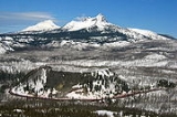
, between the prominent volcanic horns of Three Fingered Jack
to the north and Mount Washington to the south. Several other smaller volcanoes, including cinder cone
s and tuya
s, are found near the summit of the pass. U.S. Route 20 connects eastern Oregon with the valley of the Santiam River
on the west via Santiam Pass. One of the 19 or 20 lakes by the name of Lost Lake
is located beside the highway just west of Santiam Pass. The Santiam Pass may be approached from the west by 3 distinct routes:
From the East, Santiam Pass is approached from the town of Sisters
, however, immediately east of Sisters U. S. Highway 20 and Oregon Route 126 which share the route over the pass split with Oregon Route 126 going Northest to Redmond
and Prineville, Oregon
and U. S. Route 20 heading southeast to Bend
.
While the pass was known by native
peoples, the first recorded crossing of the pass was in April 1859 by an expedition searching for a cattle trail over the Cascade Range from the Willamette Valley
to Central Oregon
. This expedition was led by Andrew Wiley, who reportedly climbed a tall tree on a mountain near Lost Prairie to help determine the route. Lost Prairie is located along Hackleman Creek between Fish Lake and Tombstone Prairie. Wiley later helped establish the Santiam Wagon Road
.
Mountain pass
A mountain pass is a route through a mountain range or over a ridge. If following the lowest possible route, a pass is locally the highest point on that route...
in the Cascade Range
Cascade Range
The Cascade Range is a major mountain range of western North America, extending from southern British Columbia through Washington and Oregon to Northern California. It includes both non-volcanic mountains, such as the North Cascades, and the notable volcanoes known as the High Cascades...
in central Oregon
Oregon
Oregon is a state in the Pacific Northwest region of the United States. It is located on the Pacific coast, with Washington to the north, California to the south, Nevada on the southeast and Idaho to the east. The Columbia and Snake rivers delineate much of Oregon's northern and eastern...
in the United States
United States
The United States of America is a federal constitutional republic comprising fifty states and a federal district...
. It is located on the border between Linn
Linn County, Oregon
Linn County is a county located in the U.S. state of Oregon. It is named in honor of Lewis F. Linn, a U.S. Senator from Missouri who advocated the American occupation of the Oregon Country. By the 2010 US census the population of Linn county was 116,672 showing a 13.2% growth since the 2000 census...
and Jefferson
Jefferson County, Oregon
Jefferson County is a county located in the U.S. state of Oregon. In 2010, its population was 21,720. It is named after Mount Jefferson. The seat of the county is Madras.-History:...
counties, about 18 mi (29 km) northwest of Sisters
Sisters, Oregon
Sisters is a city in Deschutes County, Oregon, United States. It is part of the Bend, Oregon Metropolitan Statistical Area. The population was 959 at the 2000 census, but more than doubled to 2038 as of the 2010 census.- History :...
, between the prominent volcanic horns of Three Fingered Jack
Three Fingered Jack
Three Fingered Jack, named for its distinctive shape, is a Pleistocene volcano in the Cascade Range of Oregon. It is a deeply glaciated shield volcano and consists mainly of basaltic andesite lava...
to the north and Mount Washington to the south. Several other smaller volcanoes, including cinder cone
Cinder cone
According to the , Cinder Cone is the proper name of 1 cinder cone in Canada and 7 cinder cones in the United States:In Canada: Cinder Cone In the United States:...
s and tuya
Tuya
A tuya is a type of distinctive, flat-topped, steep-sided volcano formed when lava erupts through a thick glacier or ice sheet. They are somewhat rare worldwide, being confined to regions which were covered by glaciers and also had active volcanism during the same time period.-Formation:Tuyas are...
s, are found near the summit of the pass. U.S. Route 20 connects eastern Oregon with the valley of the Santiam River
Santiam River
The Santiam River is a tributary of the Willamette River, about long, in western Oregon in the United States. Through its two principal tributaries, the North Santiam and the South Santiam rivers, it drains a large area of the Cascade Range at the eastern side of the Willamette Valley east of...
on the west via Santiam Pass. One of the 19 or 20 lakes by the name of Lost Lake
Lost Lake (Oregon)
Oregon has at least 19 lakes named Lost Lake:...
is located beside the highway just west of Santiam Pass. The Santiam Pass may be approached from the west by 3 distinct routes:
- Oregon Route 22 also known as the North Santiam Highway proceeds southeast from SalemSalem, OregonSalem is the capital of the U.S. state of Oregon, and the county seat of Marion County. It is located in the center of the Willamette Valley alongside the Willamette River, which runs north through the city. The river forms the boundary between Marion and Polk counties, and the city neighborhood...
and follows the North Santiam RiverNorth Santiam RiverThe North Santiam River is a tributary of the Santiam River in western Oregon in the United States. It drains of the Cascade Range on the eastern side of the Willamette Valley east of Salem....
to Santiam Junction. - U.S. Route 20 which follows the South Santiam RiverSouth Santiam RiverThe South Santiam River is a tributary of the Santiam River, about long, in western Oregon in the United States. It drains an area of the Cascade Range into the Willamette Valley east of Corvallis....
from the AlbanyAlbany, OregonAlbany is the eleventh largest city in the U.S. state of Oregon, and is the county seat of Linn County. It is located in the Willamette Valley at the confluence of the Calapooia River and the Willamette River in both Linn and Benton counties, just east of Corvallis and south of Salem. It is...
-CorvallisCorvallis, OregonCorvallis is a city located in central western Oregon, United States. It is the county seat of Benton County and the principal city of the Corvallis, Oregon Metropolitan Statistical Area, which encompasses all of Benton County. As of the 2010 United States Census, the population was 54,462....
area to Santiam Junction. - Oregon Route 126 which follows the McKenzie RiverMcKenzie RiverThe McKenzie River is a tributary of the Willamette River in western Oregon in the United States. It drains part of the Cascade Range east of Eugene and flows into the southernmost end of the Willamette Valley. It is named for Donald MacKenzie, a Scottish Canadian fur trader...
northeast from EugeneEugene, OregonEugene is the second largest city in the U.S. state of Oregon and the seat of Lane County. It is located at the south end of the Willamette Valley, at the confluence of the McKenzie and Willamette rivers, about east of the Oregon Coast.As of the 2010 U.S...
.
From the East, Santiam Pass is approached from the town of Sisters
Sisters, Oregon
Sisters is a city in Deschutes County, Oregon, United States. It is part of the Bend, Oregon Metropolitan Statistical Area. The population was 959 at the 2000 census, but more than doubled to 2038 as of the 2010 census.- History :...
, however, immediately east of Sisters U. S. Highway 20 and Oregon Route 126 which share the route over the pass split with Oregon Route 126 going Northest to Redmond
Redmond, Oregon
Redmond is a city in Deschutes County, Oregon, United States. Incorporated on July 6, 1910, the city is located on the eastern side of Oregon's Cascade Range, in the High Desert, and is considered the geographical heart of Central Oregon...
and Prineville, Oregon
Prineville, Oregon
Prineville is a city in and the county seat of Crook County, Oregon, United States. It was named for the first merchant located in the present location, Barney Prine. The population was 9,253 at the 2010 census.- History :...
and U. S. Route 20 heading southeast to Bend
Bend, Oregon
Bend is a city in and the county seat of Deschutes County, Oregon, United States, and the principal city of the Bend, Oregon Metropolitan Statistical Area. Bend is Central Oregon's largest city, and, despite its modest size, is the de facto metropolis of the region, owing to the low population...
.
While the pass was known by native
Native Americans in the United States
Native Americans in the United States are the indigenous peoples in North America within the boundaries of the present-day continental United States, parts of Alaska, and the island state of Hawaii. They are composed of numerous, distinct tribes, states, and ethnic groups, many of which survive as...
peoples, the first recorded crossing of the pass was in April 1859 by an expedition searching for a cattle trail over the Cascade Range from the Willamette Valley
Willamette Valley
The Willamette Valley is the most populated region in the state of Oregon of the United States. Located in the state's northwest, the region is surrounded by tall mountain ranges to the east, west and south and the valley's floor is broad, flat and fertile because of Ice Age conditions...
to Central Oregon
Central Oregon
Central Oregon is a geographic region in the U.S. state of Oregon and is traditionally considered to be made up of Deschutes, Jefferson, and Crook counties. Other definitions include larger areas, often encompassing areas to the north towards the Columbia River, eastward towards Burns, or south...
. This expedition was led by Andrew Wiley, who reportedly climbed a tall tree on a mountain near Lost Prairie to help determine the route. Lost Prairie is located along Hackleman Creek between Fish Lake and Tombstone Prairie. Wiley later helped establish the Santiam Wagon Road
Santiam Wagon Road
The Santiam Wagon Road was a freight route in the U.S. state of Oregon between the Willamette Valley and Central Oregon regions from 1865 to the 1930s. It is considered one of the most important historical routes in the state...
.
Nearby Volcanoes
- Three Fingered JackThree Fingered JackThree Fingered Jack, named for its distinctive shape, is a Pleistocene volcano in the Cascade Range of Oregon. It is a deeply glaciated shield volcano and consists mainly of basaltic andesite lava...
- Hogg RockHogg RockHogg Rock is a tuya volcano in the Cascade Range of northern Oregon, located west of Santiam Pass beside the Santiam Highway . The highway wraps in a nearly 180-degree curve below cliffs on the south and west sides....
- Hoodoo ButteHoodoo ButteHoodoo Butte is a cinder cone butte in the Cascade Range of northern Oregon, located near Santiam Pass just west of the Cascade Crest. A ski area, also named Hoodoo, is located on the northwest through northeast flanks of the cone, and the summit area includes the top stations of two chairlifts...
- Hayrick ButteHayrick ButteHayrick Butte is a tuya volcano in the Cascade Range of northern Oregon, located near Santiam Pass just west of the Cascade Crest. It is adjacent to the cinder cone, Hoodoo Butte, which overlaps its western edge....
- Mount WashingtonMount Washington (Oregon)Mount Washington is a deeply eroded shield volcano in the Cascade Range of Oregon. The mountain dates to the Late Pleistocene. However, it does have a line of basaltic andesite spatter cones on its northeast flank which are approximately 1,330 years old according to carbon dating...
See also
- Santiam Junction State AirportSantiam Junction State AirportSantiam Junction State Airport , is a public airport located adjacent to Santiam Junction in Linn County, Oregon, USA. Santiam Junction is the intersection of U.S. Route 20 and Oregon Route 22. The Oregon Department of Transportation has a maintenance facility located on the north side of the...
, located west of the pass along U.S. Route 20 - McKenzie-Santiam Pass Scenic BywayMcKenzie-Santiam Pass Scenic BywayThe McKenzie – Santiam Pass Scenic Byway is an National Scenic Byway in the U.S. state of Oregon. The route is a loop designed to provide a tour of the high Cascade Range northwest of Bend, passing over both McKenzie Pass and Santiam Pass.-Route description:...