

Transport in Cambridge
Encyclopedia
Cambridge
is a university town
and the administrative centre of the county of Cambridgeshire
, England
. It lies in East Anglia
about 50 miles (80 km) north of London
.
sites all of which operate seven days a week and are aimed at encouraging motorists to park near the city's edge. Since 7 August 2011, the Cambridgeshire Guided Busway
has bus services running into the centre of Cambridge.
Most buses run to and from the bus station located on Drummer Street in the heart of the city, although there are significant interchanges at the railway station and at Addenbrooke's Hospital
. The principal operator is Stagecoach
.
is the world's longest guided bus
way and passes through Cambridge. The designated route runs on normal road from Huntingdon
to St Ives
, then via an bus-only guided section along a former railway line south-westwards into Cambridge, where it rejoins the road at either Milton Road or Histon Road and then continues to Cambridge railway station
on normal roads. From there it will again be guided to Addenbrooke's Hospital
and Trumpington
Park and Ride. The scheme, budgeted at £116.2 million, had been scheduled to open in early 2009 but opening in August 2011. The scheme had been heavily criticised by campaigners who believed that the route would be better served by restoring the existing railway route.
scheme. Five sites on the outskirts of the city or just outside its boundaries - at Babraham Road, Madingley Road, Milton
, Newmarket Road and Trumpington
- provide parking spaces for a total of over 4,500 cars. Buses run from these sites into the city centre.
from east London
terminates to the north-west of the city where it joins the A14. Skirting the northern edge Cambridge, the A14 is a major freight route which connects the port of Felixstowe
on the east coast with the Midlands
, North Wales
, the west coast and Ireland
. The A14 is often congested, particularly the section between Huntingdon
and Cambridge where the east–west traffic is merged with the A1 to M11
north–south traffic on a 2-lane dual carriageway. Cambridge is situated on the A10, a former Roman road
from north London
to Ely
and King's Lynn
. The A428 connects the city with Bedford and St Neots
, and the A1303 to Newmarket and beyond to Colchester.
Some roads around the city have been designated as forming a ring road
about a mile and a half in diameter, inside which there are traffic restrictions.
There are five council
car parks in the city centre. There are limited numbers of metered bays offering parking for up to 1–8 hours across the city
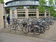 As a university town lying on fairly flat ground and with traffic congestion, Cambridge has a large number of cyclists. Many residents also prefer cycling to driving in the narrow, busy streets, giving the city the highest level of cycle use in the UK. According to the 2001 census, 25% of residents travelled to work by bicycle. A few roads within the city are adapted for cycling, including separate traffic lights for cycle lanes and cycle contraflows on streets which are otherwise one-way; the city also benefits from parks which have shared use paths. There are, however, no separate cycle paths within the city centre. Despite the high levels of cycling, expenditure on cycling infrastructure is around the national average of 0.3% of the transport budget. There are a few cycle routes in the surrounding countryside and the city is now linked to the National Cycle Network
. The main organisation campaigning to improve conditions for cyclists in Cambridge is the Cambridge Cycling Campaign. The city was chosen as a Cycling Town by the Department for Transport
in 2008, with central government funding an expansion of cycling facilities in the city and its surrounding villages.
Bike theft in the city is a problem, with over 3000 bicycles reported stolen between April 2005 and March 2006. The actual number is believed to be higher as many thefts are not reported to the police.
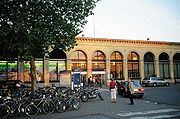 Cambridge railway station
was built in 1845 with a platform designed to take two full-length trains, the third longest in the country. Cambridge has direct rail links to London with termini at (on the Hitchin-Cambridge Line and the East Coast Main Line
) and (on the West Anglia Main Line
). There is a direct shuttle service to King's Cross every half hour during off peak hours. Peak hour trains to King's Cross all have additional stops. Future developments for the Cambridge to London line include the provision of 125 miles per hour (56 m/s) high speed trains from 2013. The line is currently graded for 100 miles per hour (45 m/s). The line is all welded rail, but because of the flat geography there are many level crossing
s, and they make it harder to run at higher speeds.
Cambridge is linked by rail to and (via the Fen Line
), (via the Breckland Line
), , Birmingham New Street, and London Stansted Airport
. The important UK rail hub of is also less than an hour from Cambridge.
The railway service connecting Cambridge and Oxford, known as the Varsity Line
, ceased in 1968. The East West Rail Link proposal now plans to reinstate a direct rail route to Oxford.
at 28 miles (45 km) and London Luton Airport
at 32 miles (51 km), London Gatwick Airport
and London Heathrow Airport
both being about 90 minutes' travel, and the smaller London City Airport
.
The city's own airport is Cambridge Airport
(formerly Marshall Airport Cambridge UK and originally Teversham Aerodrome) and is owned by Marshall Aerospace
. There are no scheduled passenger services, though the runway can accommodate an unladen Boeing 747
or MD-11
and ScotAirways
used to make scheduled flights to Amsterdam Schiphol Airport
. The airport is used mainly by business, leisure and training flights, and to fly in aircraft for maintenance. In 2004 a charter service to Jersey
was operated by Aurigny Air Services
using Saab 340
turboprop
aircraft. A dealer in fibreglass
-moulded light monoplanes is also based at the airport. Controversially it has been mooted to remove Marshalls to a site away from the city, and develop the land with housing. Sir Arthur Marshall
, the founder of the company, died in 2007.
, the County Council is redeveloping the area surrounding it. Work is set to commence by the end of 2010 and continue for about a year, at an estimated cost of £3.1 million. The redevelopment of the Cambridge Station area has been given the green light and has been awarded £1.5 million of central government money to help pay for the scheme. The Hills Road Bridge safety scheme is still included in the project.
.
A second railway station
in Chesterton has been proposed and in 2009 received the backing of the East of England Regional Assembly
and work would probably include a link to the nearby Cambridgeshire Guided Busway
offering services to St Ives
and Huntingdon
.
In 2009 the County Council revealed its plans to spend £25 million on renovating the area from Regent Street to the Cherry Hinton Road Junction, entitled Project Cambridge. The scheme is composed of many smaller projects with common themes of making junctions easier for pedestrians to cross, promoteing cycle use and reducing traffic. The scheme, criticised for not having had consultation with councillors or the public, is to be funded through tax increment financing
where the money would initially be borrowed and would be repaid over 25 years from increases in business tax revenue. The scheme was due to be discussed by councilors in October 2009.
A safety improvement scheme has been developed for parts of Mill Road
, due to the very high accident rate in the area. The proposal includes the removal of the road's central line and speed humps added along its length as well as reducing the speed limit along the road to 20 mph.
Cambridge
The city of Cambridge is a university town and the administrative centre of the county of Cambridgeshire, England. It lies in East Anglia about north of London. Cambridge is at the heart of the high-technology centre known as Silicon Fen – a play on Silicon Valley and the fens surrounding the...
is a university town
College town
A college town or university town is a community which is dominated by its university population...
and the administrative centre of the county of Cambridgeshire
Cambridgeshire
Cambridgeshire is a county in England, bordering Lincolnshire to the north, Norfolk to the northeast, Suffolk to the east, Essex and Hertfordshire to the south, and Bedfordshire and Northamptonshire to the west...
, England
England
England is a country that is part of the United Kingdom. It shares land borders with Scotland to the north and Wales to the west; the Irish Sea is to the north west, the Celtic Sea to the south west, with the North Sea to the east and the English Channel to the south separating it from continental...
. It lies in East Anglia
East Anglia
East Anglia is a traditional name for a region of eastern England, named after an ancient Anglo-Saxon kingdom, the Kingdom of the East Angles. The Angles took their name from their homeland Angeln, in northern Germany. East Anglia initially consisted of Norfolk and Suffolk, but upon the marriage of...
about 50 miles (80 km) north of London
London
London is the capital city of :England and the :United Kingdom, the largest metropolitan area in the United Kingdom, and the largest urban zone in the European Union by most measures. Located on the River Thames, London has been a major settlement for two millennia, its history going back to its...
.
Buses
Cambridge has several bus services including routes linking five Park and RidePark and ride
Park and ride facilities are car parks with connections to public transport that allow commuters and other people wishing to travel into city centres to leave their vehicles and transfer to a bus, rail system , or carpool for the rest of their trip...
sites all of which operate seven days a week and are aimed at encouraging motorists to park near the city's edge. Since 7 August 2011, the Cambridgeshire Guided Busway
Cambridgeshire Guided Busway
The Cambridgeshire Guided Busway , branded the busway , is a public transport scheme connecting the population centres of Cambridge, Huntingdon and St Ives in the English county of Cambridgeshire...
has bus services running into the centre of Cambridge.
Most buses run to and from the bus station located on Drummer Street in the heart of the city, although there are significant interchanges at the railway station and at Addenbrooke's Hospital
Addenbrooke's Hospital
Addenbrooke's Hospital is an internationally renowned teaching hospital in Cambridge, England, with strong links to the University of Cambridge. It was founded in 1766 on Trumpington Street with £4,500 from the will of Dr John Addenbrooke, a fellow of St Catharine's College...
. The principal operator is Stagecoach
Stagecoach Group
Stagecoach Group plc is an international transport group operating buses, trains, trams, express coaches and ferries. The group was founded in 1980 by the current chairman, Sir Brian Souter, his sister, Ann Gloag, and her former husband Robin...
.
Cambridgeshire Guided Busway
Cambridgeshire Guided BuswayCambridgeshire Guided Busway
The Cambridgeshire Guided Busway , branded the busway , is a public transport scheme connecting the population centres of Cambridge, Huntingdon and St Ives in the English county of Cambridgeshire...
is the world's longest guided bus
Guided bus
Guided buses are buses steered for part or all of their route by external means, usually on a dedicated track. This track, which often parallels existing roads, excludes other traffic, permitting the maintenance of reliable schedules on heavily used corridors even during rush hours.Guidance systems...
way and passes through Cambridge. The designated route runs on normal road from Huntingdon
Huntingdon
Huntingdon is a market town in Cambridgeshire, England. The town was chartered by King John in 1205. It is the traditional county town of Huntingdonshire, and is currently the seat of the Huntingdonshire district council. It is known as the birthplace in 1599 of Oliver Cromwell.-History:Huntingdon...
to St Ives
St Ives, Cambridgeshire
St Ives is a market town in Cambridgeshire, England, around north-west of the city of Cambridge and north of London. It lies within the historic county boundaries of Huntingdonshire.-History:...
, then via an bus-only guided section along a former railway line south-westwards into Cambridge, where it rejoins the road at either Milton Road or Histon Road and then continues to Cambridge railway station
Cambridge railway station
Cambridge railway station is a railway station serving the city of Cambridge in Cambridgeshire, England. It is located at the end of Station Road, off Hills Road, 1 mile south-east of the city centre...
on normal roads. From there it will again be guided to Addenbrooke's Hospital
Addenbrooke's Hospital
Addenbrooke's Hospital is an internationally renowned teaching hospital in Cambridge, England, with strong links to the University of Cambridge. It was founded in 1766 on Trumpington Street with £4,500 from the will of Dr John Addenbrooke, a fellow of St Catharine's College...
and Trumpington
Trumpington, Cambridgeshire
Trumpington is a village within the city of Cambridge, UK, of which it is a suburb. It is located on the south-west side of the city and borders Cherry Hinton to the east, Grantchester to the west and Great Shelford and Little Shelford to the south-east....
Park and Ride. The scheme, budgeted at £116.2 million, had been scheduled to open in early 2009 but opening in August 2011. The scheme had been heavily criticised by campaigners who believed that the route would be better served by restoring the existing railway route.
Park and ride
The city is served by a seven days a week park and ridePark and ride
Park and ride facilities are car parks with connections to public transport that allow commuters and other people wishing to travel into city centres to leave their vehicles and transfer to a bus, rail system , or carpool for the rest of their trip...
scheme. Five sites on the outskirts of the city or just outside its boundaries - at Babraham Road, Madingley Road, Milton
Milton, Cambridgeshire
Milton is a village just north of Cambridge, England. It has a population of approximately 4,300 with 3,200 being on the electoral register. It expanded considerably in the late 1980s when two large housing estates were built between the bypass and the village resulting in a doubling of the...
, Newmarket Road and Trumpington
Trumpington
Trumpington may refer to:*Trumpington, Cambridgeshire, a suburb of the city of Cambridge, UK.*Trumpington, Maryland, a registered historic place in Maryland, U.S.*Jean Barker, Baroness Trumpington, a life peer of the United Kingdom...
- provide parking spaces for a total of over 4,500 cars. Buses run from these sites into the city centre.
Roads
Because of its rapid growth in the 20th century, Cambridge has a congested road network. Several major roads intersect at Cambridge. The M11 motorwayM11 motorway
The M11 motorway in England is a major road running approximately north from the North Circular Road in South Woodford in north-east London to the A14, north-west of Cambridge.-Route:...
from east London
London
London is the capital city of :England and the :United Kingdom, the largest metropolitan area in the United Kingdom, and the largest urban zone in the European Union by most measures. Located on the River Thames, London has been a major settlement for two millennia, its history going back to its...
terminates to the north-west of the city where it joins the A14. Skirting the northern edge Cambridge, the A14 is a major freight route which connects the port of Felixstowe
Felixstowe
Felixstowe is a seaside town on the North Sea coast of Suffolk, England. The town gives its name to the nearby Port of Felixstowe, which is the largest container port in the United Kingdom and is owned by Hutchinson Ports UK...
on the east coast with the Midlands
English Midlands
The Midlands, or the English Midlands, is the traditional name for the area comprising central England that broadly corresponds to the early medieval Kingdom of Mercia. It borders Southern England, Northern England, East Anglia and Wales. Its largest city is Birmingham, and it was an important...
, North Wales
Wales
Wales is a country that is part of the United Kingdom and the island of Great Britain, bordered by England to its east and the Atlantic Ocean and Irish Sea to its west. It has a population of three million, and a total area of 20,779 km²...
, the west coast and Ireland
Ireland
Ireland is an island to the northwest of continental Europe. It is the third-largest island in Europe and the twentieth-largest island on Earth...
. The A14 is often congested, particularly the section between Huntingdon
Huntingdon
Huntingdon is a market town in Cambridgeshire, England. The town was chartered by King John in 1205. It is the traditional county town of Huntingdonshire, and is currently the seat of the Huntingdonshire district council. It is known as the birthplace in 1599 of Oliver Cromwell.-History:Huntingdon...
and Cambridge where the east–west traffic is merged with the A1 to M11
M11 motorway
The M11 motorway in England is a major road running approximately north from the North Circular Road in South Woodford in north-east London to the A14, north-west of Cambridge.-Route:...
north–south traffic on a 2-lane dual carriageway. Cambridge is situated on the A10, a former Roman road
Roman road
The Roman roads were a vital part of the development of the Roman state, from about 500 BC through the expansion during the Roman Republic and the Roman Empire. Roman roads enabled the Romans to move armies and trade goods and to communicate. The Roman road system spanned more than 400,000 km...
from north London
London
London is the capital city of :England and the :United Kingdom, the largest metropolitan area in the United Kingdom, and the largest urban zone in the European Union by most measures. Located on the River Thames, London has been a major settlement for two millennia, its history going back to its...
to Ely
Ely, Cambridgeshire
Ely is a cathedral city in Cambridgeshire, England, 14 miles north-northeast of Cambridge and about by road from London. It is built on a Lower Greensand island, which at a maximum elevation of is the highest land in the Fens...
and King's Lynn
King's Lynn
King's Lynn is a sea port and market town in the ceremonial county of Norfolk in the East of England. It is situated north of London and west of Norwich. The population of the town is 42,800....
. The A428 connects the city with Bedford and St Neots
St Neots
St Neots is a town and civil parish with a population of 26,356 people. It lies on the River Great Ouse in Huntingdonshire District, approximately north of central London, and is the largest town in Cambridgeshire . The town is named after the Cornish monk St...
, and the A1303 to Newmarket and beyond to Colchester.
Some roads around the city have been designated as forming a ring road
Ring road
A ring road, orbital motorway, beltway, circumferential highway, or loop highway is a road that encircles a town or city...
about a mile and a half in diameter, inside which there are traffic restrictions.
There are five council
Cambridge City Council
Cambridge City Council may refer to:* Cambridge City Council, England* Cambridge City Council, Massachusetts, USA* Cambridge, Ontario City Council, Canada...
car parks in the city centre. There are limited numbers of metered bays offering parking for up to 1–8 hours across the city
Cycling
National Cycle Network
The National Cycle Network is a network of cycle routes in the United Kingdom.The National Cycle Network was created by the charity Sustrans , and aided by a £42.5 million National Lottery grant. In 2005 it was used for over 230 million trips.Many routes hope to minimise contact with motor...
. The main organisation campaigning to improve conditions for cyclists in Cambridge is the Cambridge Cycling Campaign. The city was chosen as a Cycling Town by the Department for Transport
Department for Transport
In the United Kingdom, the Department for Transport is the government department responsible for the English transport network and a limited number of transport matters in Scotland, Wales and Northern Ireland which are not devolved...
in 2008, with central government funding an expansion of cycling facilities in the city and its surrounding villages.
Bike theft in the city is a problem, with over 3000 bicycles reported stolen between April 2005 and March 2006. The actual number is believed to be higher as many thefts are not reported to the police.
Rail
Cambridge railway station
Cambridge railway station is a railway station serving the city of Cambridge in Cambridgeshire, England. It is located at the end of Station Road, off Hills Road, 1 mile south-east of the city centre...
was built in 1845 with a platform designed to take two full-length trains, the third longest in the country. Cambridge has direct rail links to London with termini at (on the Hitchin-Cambridge Line and the East Coast Main Line
East Coast Main Line
The East Coast Main Line is a long electrified high-speed railway link between London, Peterborough, Doncaster, Wakefield, Leeds, York, Darlington, Newcastle and Edinburgh...
) and (on the West Anglia Main Line
West Anglia Main Line
The West Anglia Main Line is one of the two main lines which run from London Liverpool Street, the other being the Great Eastern Main Line. It runs generally north from London, through the towns of Cheshunt, Broxbourne, Harlow, Bishop's Stortford and Audley End station before reaching Cambridge,...
). There is a direct shuttle service to King's Cross every half hour during off peak hours. Peak hour trains to King's Cross all have additional stops. Future developments for the Cambridge to London line include the provision of 125 miles per hour (56 m/s) high speed trains from 2013. The line is currently graded for 100 miles per hour (45 m/s). The line is all welded rail, but because of the flat geography there are many level crossing
Level crossing
A level crossing occurs where a railway line is intersected by a road or path onone level, without recourse to a bridge or tunnel. It is a type of at-grade intersection. The term also applies when a light rail line with separate right-of-way or reserved track crosses a road in the same fashion...
s, and they make it harder to run at higher speeds.
Cambridge is linked by rail to and (via the Fen Line
Fen Line
The Fen Line is a railway in the United Kingdom that runs between the cities of Cambridge, Cambridgeshire and King's Lynn, Norfolk; the line is so called because it runs through The Fens. The line is part of the Network Rail Strategic Route 5 and comprises SRS 05.06 and part of 05.05...
), (via the Breckland Line
Breckland Line
The Breckland Line runs from Cambridge in Cambridgeshire to Norwich in Norfolk, in East Anglia, England. It is so called because it runs through the Breckland region of Norfolk. The line also passes through Thetford Forest. The line is part of the Network Rail Strategic Route 5, SRS 05.09 and part...
), , Birmingham New Street, and London Stansted Airport
London Stansted Airport
-Cargo:-Statistics:-Infrastructure:-Terminal and satellite buildings:Stansted is the newest passenger airport of all the main London airports. The terminal is an oblong glass building, and is separated in to three areas: Check-in concourse, arrivals and departures...
. The important UK rail hub of is also less than an hour from Cambridge.
The railway service connecting Cambridge and Oxford, known as the Varsity Line
Varsity Line
The Varsity Line is an informal name for the railway route that formerly linked the English university cities of Oxford and Cambridge, operated successively by the London and North Western Railway, the London, Midland and Scottish Railway, and British Railways...
, ceased in 1968. The East West Rail Link proposal now plans to reinstate a direct rail route to Oxford.
Air
The nearest passenger services are from London Stansted AirportLondon Stansted Airport
-Cargo:-Statistics:-Infrastructure:-Terminal and satellite buildings:Stansted is the newest passenger airport of all the main London airports. The terminal is an oblong glass building, and is separated in to three areas: Check-in concourse, arrivals and departures...
at 28 miles (45 km) and London Luton Airport
London Luton Airport
London Luton Airport is an international airport located east of the town centre in the Borough of Luton in Bedfordshire, England and is north of Central London. The airport is from Junction 10a of the M1 motorway...
at 32 miles (51 km), London Gatwick Airport
London Gatwick Airport
Gatwick Airport is located 3.1 miles north of the centre of Crawley, West Sussex, and south of Central London. Previously known as London Gatwick,In 2010, the name changed from London Gatwick Airport to Gatwick Airport...
and London Heathrow Airport
London Heathrow Airport
London Heathrow Airport or Heathrow , in the London Borough of Hillingdon, is the busiest airport in the United Kingdom and the third busiest airport in the world in terms of total passenger traffic, handling more international passengers than any other airport around the globe...
both being about 90 minutes' travel, and the smaller London City Airport
London City Airport
London City Airport is a single-runway airport. It principally serves the financial district of London and is located on a former Docklands site, east of the City of London, opposite the London Regatta Centre, in the London Borough of Newham in east London. It was developed by the engineering...
.
The city's own airport is Cambridge Airport
Cambridge Airport
Cambridge Airport is a small regional airport in South Cambridgeshire, England. It is located on the eastern outskirts of Cambridge, south of Newmarket Road and west of the village of Teversham, from the centre of Cambridge and approximately from London.Opened in 1938, when it replaced the old...
(formerly Marshall Airport Cambridge UK and originally Teversham Aerodrome) and is owned by Marshall Aerospace
Marshall Aerospace
The Marshall companies have been internationally associated with aerospace engineering for nearly a century. The company employs over 1,800 people and is based on an site with of covered hangar space...
. There are no scheduled passenger services, though the runway can accommodate an unladen Boeing 747
Boeing 747
The Boeing 747 is a wide-body commercial airliner and cargo transport, often referred to by its original nickname, Jumbo Jet, or Queen of the Skies. It is among the world's most recognizable aircraft, and was the first wide-body ever produced...
or MD-11
McDonnell Douglas MD-11
The McDonnell Douglas MD-11 is a three-engine medium- to long-range widebody jet airliner, manufactured by McDonnell Douglas and, later, by Boeing Commercial Airplanes. Based on the DC-10, it features a stretched fuselage, increased wingspan with winglets, refined airfoils on the wing and smaller...
and ScotAirways
ScotAirways
Suckling Airways is an airline that focuses on ACMI work and ad hoc corporate charters for business and sporting organisations...
used to make scheduled flights to Amsterdam Schiphol Airport
Amsterdam Schiphol Airport
Amsterdam Airport Schiphol ) is the Netherlands' main international airport, located 20 minutes southwest of Amsterdam, in the municipality of Haarlemmermeer. The airport's official English name, Amsterdam Airport Schiphol, reflects the original Dutch word order...
. The airport is used mainly by business, leisure and training flights, and to fly in aircraft for maintenance. In 2004 a charter service to Jersey
Jersey
Jersey, officially the Bailiwick of Jersey is a British Crown Dependency off the coast of Normandy, France. As well as the island of Jersey itself, the bailiwick includes two groups of small islands that are no longer permanently inhabited, the Minquiers and Écréhous, and the Pierres de Lecq and...
was operated by Aurigny Air Services
Aurigny Air Services
Aurigny Air Services was founded by Sir Derrick Bailey and started operations on 1 March 1968 after British United Airways withdrew the Alderney to Guernsey route...
using Saab 340
Saab 340
The Saab 340 is a discontinued Swedish two-engine turboprop aircraft designed and initially produced by a partnership between Saab and Fairchild Aircraft in a 65:35 ratio...
turboprop
Turboprop
A turboprop engine is a type of turbine engine which drives an aircraft propeller using a reduction gear.The gas turbine is designed specifically for this application, with almost all of its output being used to drive the propeller...
aircraft. A dealer in fibreglass
Glass-reinforced plastic
Fiberglass , is a fiber reinforced polymer made of a plastic matrix reinforced by fine fibers of glass. It is also known as GFK ....
-moulded light monoplanes is also based at the airport. Controversially it has been mooted to remove Marshalls to a site away from the city, and develop the land with housing. Sir Arthur Marshall
Sir Arthur Marshall
Sir Arthur Gregory George Marshall, OBE, was a British aviation pioneer and businessman, chairman of Marshall Aerospace between 1942 and 1989.- Early life and education :...
, the founder of the company, died in 2007.
Cambridge Cycling Town
In 2008 Cambridge was awarded the status of "Cycling Town", and granted £3.6 million to spend on cycling improvements. Cambridgeshire County Council currently plans to use the money to construct six new cycle paths in the city and its surrounding area:- CottenhamCottenhamCottenham is a village in Cambridgeshire, England. It is close to The Fens. Before the fens were drained in the 19th century Cottenham was on the last contour before the waterlogged marshes, with Ely being the nearest dry land around to the north-east....
to HistonHistonHiston and Impington are villages in Cambridgeshire, England, They are situated just north of Cambridge with the main bulk of the settlements being separated from the city by the A14 road .... - Histon to Cambridge
- HarstonHarstonHarston is a village to the south of Cambridge, England.-Harston House:Harston House is a historic private house in Harston. It was formerly known as Harston Hall....
to Cambridge - Babraham Road Park & Ride to Wandlebury
- Fen DittonFen DittonFen Ditton is a village on the northeast edge of Cambridge in Cambridgeshire, England. The parish covers an area of Fen Ditton lies on the east bank of the River Cam, on the road from Cambridge to Clayhithe, and close to junction 34 of the A14...
to HorningseaHorningseaHorningsea is a small village north of Cambridge in Cambridgeshire in England. The parish covers an area of 6.63 km. It lies on the east bank of the River Cam, and on the road from Cambridge to Clayhithe... - MiltonMilton, CambridgeshireMilton is a village just north of Cambridge, England. It has a population of approximately 4,300 with 3,200 being on the electoral register. It expanded considerably in the late 1980s when two large housing estates were built between the bypass and the village resulting in a doubling of the...
to Impington
Cambridge Gateway
In order to promote safety and improve access to Cambridge railway stationCambridge railway station
Cambridge railway station is a railway station serving the city of Cambridge in Cambridgeshire, England. It is located at the end of Station Road, off Hills Road, 1 mile south-east of the city centre...
, the County Council is redeveloping the area surrounding it. Work is set to commence by the end of 2010 and continue for about a year, at an estimated cost of £3.1 million. The redevelopment of the Cambridge Station area has been given the green light and has been awarded £1.5 million of central government money to help pay for the scheme. The Hills Road Bridge safety scheme is still included in the project.
Proposed developments
Several developments to the transport system in Cambridge have been proposed, mostly by Cambridgeshire County CouncilCambridgeshire County Council
Cambridgeshire County Council is the county council of Cambridgeshire, England. The council currently consists of 69 councillors, representing 60 electoral divisions. The Conservative Party has a majority on the council, having gained control in the 1997 local elections...
.
A second railway station
Chesterton railway station
Chesterton railway station is a proposed railway station that would be located in the Cambridge suburb of Chesterton. The official proposal from Cambridgeshire County Council, which has the backing of the rail industry, is to locate the station at Chesterton Sidings on the Fen Line, which runs from...
in Chesterton has been proposed and in 2009 received the backing of the East of England Regional Assembly
East of England Regional Assembly
The East of England Regional Assembly was the regional assembly for the East of England region of the United Kingdom. It was based at Flempton, near Bury St Edmunds in Suffolk. The assembly was created as a voluntary regional chamber in 1998 by the Regional Development Agencies Act 1998. The first...
and work would probably include a link to the nearby Cambridgeshire Guided Busway
Cambridgeshire Guided Busway
The Cambridgeshire Guided Busway , branded the busway , is a public transport scheme connecting the population centres of Cambridge, Huntingdon and St Ives in the English county of Cambridgeshire...
offering services to St Ives
St Ives, Cambridgeshire
St Ives is a market town in Cambridgeshire, England, around north-west of the city of Cambridge and north of London. It lies within the historic county boundaries of Huntingdonshire.-History:...
and Huntingdon
Huntingdon
Huntingdon is a market town in Cambridgeshire, England. The town was chartered by King John in 1205. It is the traditional county town of Huntingdonshire, and is currently the seat of the Huntingdonshire district council. It is known as the birthplace in 1599 of Oliver Cromwell.-History:Huntingdon...
.
In 2009 the County Council revealed its plans to spend £25 million on renovating the area from Regent Street to the Cherry Hinton Road Junction, entitled Project Cambridge. The scheme is composed of many smaller projects with common themes of making junctions easier for pedestrians to cross, promoteing cycle use and reducing traffic. The scheme, criticised for not having had consultation with councillors or the public, is to be funded through tax increment financing
Tax increment financing
Tax Increment Financing, or TIF, is a public financing method which has been used as a subsidy for redevelopment and community improvement projects in many countries including the United States for more than 50 years...
where the money would initially be borrowed and would be repaid over 25 years from increases in business tax revenue. The scheme was due to be discussed by councilors in October 2009.
A safety improvement scheme has been developed for parts of Mill Road
Mill Road, Cambridge
Mill Road is a street in southeast Cambridge, England. It runs southeast from near to Parker's Piece, at the junction with Gonville Place, East Road, and Parkside. It crosses the main railway line and links to the city's ring road . It passes through the wards of Petersfield and Romsey, which are...
, due to the very high accident rate in the area. The proposal includes the removal of the road's central line and speed humps added along its length as well as reducing the speed limit along the road to 20 mph.