
.gif)
Hurricane Flossie (2007)
Encyclopedia
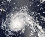
Hurricane Flossie was a strong Category Four
Hurricane
which brushed the island of Hawaiʻi as it rapidly weakened to a tropical storm. Flossie was the ninth tropical cyclone and sixth named storm of the 2007 Pacific hurricane season
. Flossie developed from an ill defined wave which formed off the coast of Africa
on July 21 and traversed the Atlantic
. The wave crossed into the Pacific
on August 2 while remaining poorly organized. The low slowly developed over the next few days before gaining enough convection to be declared a tropical depression on August 8. The depression quickly strengthened to a tropical storm early the next morning and later to a hurricane on August 10. Flossie became a major hurricane on August 11 and reached category four status just before entering the Central Pacific basin later that day. Flossie maintained a category four until August 14 when vertical wind shear
increased and began to weaken the system. Flossie brushed the southern coast of Hawaiʻi as the strong wind shear took its toll on the storm. Flossie dissipated on August 16 as it moved away from the islands without making landfall.
moved off the Africa
n coast on July 21 into the Atlantic Ocean
. The wave produced very little convection as it moved towards the west. On August 1, the wave crossed over Central America
and entered the Pacific
the next day. The low continued to produce very little convection for the next few days. On August 4, there was some increase in convection but not much. Two days later, there was a large increase in convection and the low was near tropical depression strength. However, the convection did not persist and the system weakened slightly. On August 8, the system had reorganized and gained stronger convection which persisted and the low was declared Tropical Depression 09-E later that night.
 The depression was located in an environment of low wind shear and warm sea surface temperatures, favorable for intensification, and was quickly upgraded to Tropical Storm Flossie on its second advisory. Flossie gradually intensified and was upgraded to a hurricane on August 10 as an eye
began to form. Forecasts showed that Flossie would intensify some more before entering an area that was less favorable for development which would get less favorable towards the end of the forecast period. Flossie intensified further to a strong Category One shortly after and the peak intensity in the forecast was increased to a low end Category Two.
That night, Flossie's eye became more well defined and cleared out as the storm rapidly intensified to a major hurricane as it moved out of the National Hurricane Center's area of responsibility. Flossie continued to rapidly intensify and reached Category Four status shortly after entering the Central Pacific. Forecasts showed the intensification ending and that colder water and stronger shear would begin to weaken the system in 24 hours. Flossie maintained its intensity as it continued its westward movement. The possibility of a Hawaiʻian landfall was beginning to unfold as Flossie neared the big island. Flossie again intensified slightly, with winds reaching 140 mph (225.3 km/h). Despite days of predictions to the contrary, the storm did not lose intensity, leading a forecaster at the CPHC
to remark that "Hurricane Flossie is not willing to give up."
On the morning of August 13 Hurricane Flossie began to weaken as wind shear, upper-level warming, and restricting outflow finally began to take their toll. By that night the storm's central pressure had risen to 970 mb and the persistent upper-level wind shear caused breaks in the southeast eyewall which preceded the eye's eventual collapse. Although the eye had disappeared from satellite imagery, NEXRAD
and reconnaissance
data on August 14 showed a partial eyewall open to the southeast. 29 mph (47 km/h) southwesterly wind shear decimated the storm's structure and restricted outflow, further weakening it. Satellite imagery showed portions of the eyewall uncovered again, and land-based radar showed an absence of deep convection in the southeast semicircle. Under the effects of the negative environmental conditions, Flossie's eye disappeared again, and Flossie weakened to a tropical storm late that night local time. The last advisory was issued on August 16.
of Hawaii as the storm neared the islands without weakening significantly. Later, as the hurricane tracked slightly further to the north and its wind radii expanded, a tropical storm warning was issued for the same areas as the hurricane warning. Heavy rainfall and flooding were expected to be the primary concern, and as such, flash flood watches were issued, with 10 to 15 in (254 to 381 mm) of rainfall considered possible. Also, tropical storm-force winds were expected. Governor Linda Lingle
declared a state of emergency for the Island of Hawaii, where residents were advised to stock up on necessary supplies.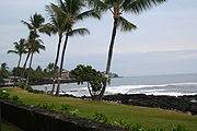 The Federal Emergency Management Agency
(FEMA) dispatched 20 transportation, public works and health experts to the region. Emergency shelters were opened, though were used little. The threat of the storm forced the closure of schools, including the University of Hawaii at Hilo
and Hawaii Community College
. Some libraries, parks, private schools, banks and other businesses were also closed. Non-essential state employees were advised to remain at home, and emergency workers were mobilized. In advance of the storm, many tourists canceled reservations.
Forecast heavy rains over the southeast-facing slopes of the Big Island failed to occur, as Flossie turned away before low level southeasterly winds had a chance to produce mountain-enhanced rainfall. However, north- and east-facing slopes received some rainfall; 1 to 2 in (0.0254 to 0.0508 m) of rain was reported in the Hamakua
, South Hilo, and Puna
Districts. Elsewhere, 1 to 3 in (25.4 to 76.2 mm) of precipitation fell at Maui
, and 2 to 4 in (50.8 to 101.6 mm) fell at the Koolau Range
on Oahu
, although no significant winds or flooding was reported. Wave action affected the southeast-facing shores, also with little impact. The most significant waves were estimated at 20 feet (6.1 m) in height, while sustained winds of at least 39 miles per hour (62.8 km/h) were reported at South Point
. A large lava bench
collapsed into the ocean on August 13, which may have been related to the hurricane's passage, or alternatively, a recent earthquake.
Saffir-Simpson Hurricane Scale
The Saffir–Simpson Hurricane Scale , or the Saffir–Simpson Hurricane Wind Scale , classifies hurricanes — Western Hemisphere tropical cyclones that exceed the intensities of tropical depressions and tropical storms — into five categories distinguished by the intensities of their sustained winds...
Hurricane
Tropical cyclone
A tropical cyclone is a storm system characterized by a large low-pressure center and numerous thunderstorms that produce strong winds and heavy rain. Tropical cyclones strengthen when water evaporated from the ocean is released as the saturated air rises, resulting in condensation of water vapor...
which brushed the island of Hawaiʻi as it rapidly weakened to a tropical storm. Flossie was the ninth tropical cyclone and sixth named storm of the 2007 Pacific hurricane season
2007 Pacific hurricane season
The 2007 Pacific hurricane season was an event in the annual cycle of tropical cyclone formation. It officially started on May 15, 2007 in the eastern Pacific, designated as the area east of 140°W, and on June 1, 2007 in the central Pacific, which is between the International Date Line and 140°W,...
. Flossie developed from an ill defined wave which formed off the coast of Africa
Africa
Africa is the world's second largest and second most populous continent, after Asia. At about 30.2 million km² including adjacent islands, it covers 6% of the Earth's total surface area and 20.4% of the total land area...
on July 21 and traversed the Atlantic
Atlantic Ocean
The Atlantic Ocean is the second-largest of the world's oceanic divisions. With a total area of about , it covers approximately 20% of the Earth's surface and about 26% of its water surface area...
. The wave crossed into the Pacific
Pacific Ocean
The Pacific Ocean is the largest of the Earth's oceanic divisions. It extends from the Arctic in the north to the Southern Ocean in the south, bounded by Asia and Australia in the west, and the Americas in the east.At 165.2 million square kilometres in area, this largest division of the World...
on August 2 while remaining poorly organized. The low slowly developed over the next few days before gaining enough convection to be declared a tropical depression on August 8. The depression quickly strengthened to a tropical storm early the next morning and later to a hurricane on August 10. Flossie became a major hurricane on August 11 and reached category four status just before entering the Central Pacific basin later that day. Flossie maintained a category four until August 14 when vertical wind shear
Wind shear
Wind shear, sometimes referred to as windshear or wind gradient, is a difference in wind speed and direction over a relatively short distance in the atmosphere...
increased and began to weaken the system. Flossie brushed the southern coast of Hawaiʻi as the strong wind shear took its toll on the storm. Flossie dissipated on August 16 as it moved away from the islands without making landfall.
Meteorological history
A poorly organized tropical waveTropical wave
Tropical waves, easterly waves, or tropical easterly waves, also known as African easterly waves in the Atlantic region, are a type of atmospheric trough, an elongated area of relatively low air pressure, oriented north to south, which move from east to west across the tropics causing areas of...
moved off the Africa
Africa
Africa is the world's second largest and second most populous continent, after Asia. At about 30.2 million km² including adjacent islands, it covers 6% of the Earth's total surface area and 20.4% of the total land area...
n coast on July 21 into the Atlantic Ocean
Atlantic Ocean
The Atlantic Ocean is the second-largest of the world's oceanic divisions. With a total area of about , it covers approximately 20% of the Earth's surface and about 26% of its water surface area...
. The wave produced very little convection as it moved towards the west. On August 1, the wave crossed over Central America
Central America
Central America is the central geographic region of the Americas. It is the southernmost, isthmian portion of the North American continent, which connects with South America on the southeast. When considered part of the unified continental model, it is considered a subcontinent...
and entered the Pacific
Pacific Ocean
The Pacific Ocean is the largest of the Earth's oceanic divisions. It extends from the Arctic in the north to the Southern Ocean in the south, bounded by Asia and Australia in the west, and the Americas in the east.At 165.2 million square kilometres in area, this largest division of the World...
the next day. The low continued to produce very little convection for the next few days. On August 4, there was some increase in convection but not much. Two days later, there was a large increase in convection and the low was near tropical depression strength. However, the convection did not persist and the system weakened slightly. On August 8, the system had reorganized and gained stronger convection which persisted and the low was declared Tropical Depression 09-E later that night.
Eye (cyclone)
The eye is a region of mostly calm weather found at the center of strong tropical cyclones. The eye of a storm is a roughly circular area and typically 30–65 km in diameter. It is surrounded by the eyewall, a ring of towering thunderstorms where the second most severe weather of a cyclone...
began to form. Forecasts showed that Flossie would intensify some more before entering an area that was less favorable for development which would get less favorable towards the end of the forecast period. Flossie intensified further to a strong Category One shortly after and the peak intensity in the forecast was increased to a low end Category Two.
That night, Flossie's eye became more well defined and cleared out as the storm rapidly intensified to a major hurricane as it moved out of the National Hurricane Center's area of responsibility. Flossie continued to rapidly intensify and reached Category Four status shortly after entering the Central Pacific. Forecasts showed the intensification ending and that colder water and stronger shear would begin to weaken the system in 24 hours. Flossie maintained its intensity as it continued its westward movement. The possibility of a Hawaiʻian landfall was beginning to unfold as Flossie neared the big island. Flossie again intensified slightly, with winds reaching 140 mph (225.3 km/h). Despite days of predictions to the contrary, the storm did not lose intensity, leading a forecaster at the CPHC
Central Pacific Hurricane Center
The Central Pacific Hurricane Center of the United States National Weather Service is the official body responsible for tracking and issuing tropical cyclone warnings, watches, advisories, discussions, and statements for the Central North Pacific Basin...
to remark that "Hurricane Flossie is not willing to give up."
On the morning of August 13 Hurricane Flossie began to weaken as wind shear, upper-level warming, and restricting outflow finally began to take their toll. By that night the storm's central pressure had risen to 970 mb and the persistent upper-level wind shear caused breaks in the southeast eyewall which preceded the eye's eventual collapse. Although the eye had disappeared from satellite imagery, NEXRAD
NEXRAD
NEXRAD or Nexrad is a network of 159 high-resolution Doppler weather radars operated by the National Weather Service, an agency of the National Oceanic and Atmospheric Administration within the United States Department of Commerce...
and reconnaissance
Hurricane Hunters
The Hurricane Hunters are aircraft that fly into tropical cyclones in the North Atlantic Ocean and Northeastern Pacific Ocean for the specific purpose of directly measuring weather data in and around those storms. In the United States, the Air Force, Navy, and NOAA units have all participated in...
data on August 14 showed a partial eyewall open to the southeast. 29 mph (47 km/h) southwesterly wind shear decimated the storm's structure and restricted outflow, further weakening it. Satellite imagery showed portions of the eyewall uncovered again, and land-based radar showed an absence of deep convection in the southeast semicircle. Under the effects of the negative environmental conditions, Flossie's eye disappeared again, and Flossie weakened to a tropical storm late that night local time. The last advisory was issued on August 16.
Preparations and impact
The CPHC issued a hurricane watch on August 13 for the Big IslandHawaii (island)
The Island of Hawaii, also called the Big Island or Hawaii Island , is a volcanic island in the North Pacific Ocean...
of Hawaii as the storm neared the islands without weakening significantly. Later, as the hurricane tracked slightly further to the north and its wind radii expanded, a tropical storm warning was issued for the same areas as the hurricane warning. Heavy rainfall and flooding were expected to be the primary concern, and as such, flash flood watches were issued, with 10 to 15 in (254 to 381 mm) of rainfall considered possible. Also, tropical storm-force winds were expected. Governor Linda Lingle
Linda Lingle
Linda Lingle was the sixth Governor of Hawaii. Lingle holds a number of distinctions: first Republican elected governor of Hawaii since the departure of William F...
declared a state of emergency for the Island of Hawaii, where residents were advised to stock up on necessary supplies.
Federal Emergency Management Agency
The Federal Emergency Management Agency is an agency of the United States Department of Homeland Security, initially created by Presidential Reorganization Plan No. 1 of 1978 and implemented by two Executive Orders...
(FEMA) dispatched 20 transportation, public works and health experts to the region. Emergency shelters were opened, though were used little. The threat of the storm forced the closure of schools, including the University of Hawaii at Hilo
University of Hawaii at Hilo
The University of Hawaii at Hilo, UHH, or UH Hilo is one of the ten branches of the University of Hawaii system anchored by the University of Hawaii at Mānoa in Honolulu, Hawaii...
and Hawaii Community College
Hawaii Community College
Hawaii Community College is a public, co-educational commuter college in Hilo, Hawaii on the Island of Hawaii. It is one of ten branches of the University of Hawaii system anchored by the University of Hawaii at Mānoa in Honolulu and is accredited by the Western Association of Schools and...
. Some libraries, parks, private schools, banks and other businesses were also closed. Non-essential state employees were advised to remain at home, and emergency workers were mobilized. In advance of the storm, many tourists canceled reservations.
Forecast heavy rains over the southeast-facing slopes of the Big Island failed to occur, as Flossie turned away before low level southeasterly winds had a chance to produce mountain-enhanced rainfall. However, north- and east-facing slopes received some rainfall; 1 to 2 in (0.0254 to 0.0508 m) of rain was reported in the Hamakua
Hamakua
thumb|right|280px|Districts of [[Hawaii |Hawaii island]]: from northernmost, clockwise; [[Kohala, Hawaii|Kohala]], Hāmākua , [[Hilo, Hawaii|Hilo]], [[Puna, Hawaii|Puna]], [[Kau, Hawaii|Kaū]], [[Kona District, Hawaii|Kona]]...
, South Hilo, and Puna
Puna, Hawaii
Puna is one of the nine districts in Hawaii County, Big Island, Hawaii. The District of Puna is located on the easternmost portion of the island and shares borders to the north with the District of South Hilo and a border to the west with the District of Kaū...
Districts. Elsewhere, 1 to 3 in (25.4 to 76.2 mm) of precipitation fell at Maui
Maui
The island of Maui is the second-largest of the Hawaiian Islands at and is the 17th largest island in the United States. Maui is part of the state of Hawaii and is the largest of Maui County's four islands, bigger than Lānai, Kahoolawe, and Molokai. In 2010, Maui had a population of 144,444,...
, and 2 to 4 in (50.8 to 101.6 mm) fell at the Koolau Range
Koolau Range
Koolau Range is a name given to the fragmented remnant of the eastern or windward shield volcano of the Hawaiian island of Oahu. It is not a mountain range in the normal sense, because it was formed as a single mountain called Koolau Volcano...
on Oahu
Oahu
Oahu or Oahu , known as "The Gathering Place", is the third largest of the Hawaiian Islands and most populous of the islands in the U.S. state of Hawaii. The state capital Honolulu is located on the southeast coast...
, although no significant winds or flooding was reported. Wave action affected the southeast-facing shores, also with little impact. The most significant waves were estimated at 20 feet (6.1 m) in height, while sustained winds of at least 39 miles per hour (62.8 km/h) were reported at South Point
Ka Lae
Ka Lae , also known as South Point, is the southernmost point of the Big Island of Hawaii and of the 50 United States. The Ka Lae area is registered as a National Historic Landmark District under the name South Point Complex...
. A large lava bench
Lava bench
A lava bench is a volcanic landform with a horizontal surface raised above the level of the surrounding area. They are created when molten lava travels away from a volcanic vent and expands an old shoreline. If a newly formed lava bench rests on sediments, it may pose hazards due to its extremely...
collapsed into the ocean on August 13, which may have been related to the hurricane's passage, or alternatively, a recent earthquake.
See also
- List of Hawaii hurricanes
- Other storms of the same name
- Timeline of the 2007 Pacific hurricane seasonTimeline of the 2007 Pacific hurricane seasonThe 2007 Pacific hurricane season was an event in the annual cycle of tropical cyclone formation. This timeline documents all the storm formations, strengthening, weakening, landfalls, extratropical transitions, and dissipation...
External links
- NHC archive on Hurricane Flossie.
- CPHC archive on Hurricane Flossie.