

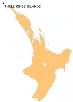
Three Kings Islands
Encyclopedia
Maori language
Māori or te reo Māori , commonly te reo , is the language of the indigenous population of New Zealand, the Māori. It has the status of an official language in New Zealand...
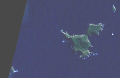
) are a group of 13 islands about 55 kilometres (34.2 mi) northwest of Cape Reinga
Cape Reinga
Cape Reinga is the northwesternmost tip of the Aupouri Peninsula, at the northern end of the North Island of New Zealand. Cape Reinga is located over 100 km north of the nearest small town of Kaitaia. State Highway 1 extends all the way to the Cape, but until 2010 was unsealed gravel road for the...
, the northernmost point of the North Island
North Island
The North Island is one of the two main islands of New Zealand, separated from the much less populous South Island by Cook Strait. The island is in area, making it the world's 14th-largest island...
of New Zealand
New Zealand
New Zealand is an island country in the south-western Pacific Ocean comprising two main landmasses and numerous smaller islands. The country is situated some east of Australia across the Tasman Sea, and roughly south of the Pacific island nations of New Caledonia, Fiji, and Tonga...
, where the South Pacific Ocean
Pacific Ocean
The Pacific Ocean is the largest of the Earth's oceanic divisions. It extends from the Arctic in the north to the Southern Ocean in the south, bounded by Asia and Australia in the west, and the Americas in the east.At 165.2 million square kilometres in area, this largest division of the World...
and Tasman Sea
Tasman Sea
The Tasman Sea is the large body of water between Australia and New Zealand, approximately across. It extends 2,800 km from north to south. It is a south-western segment of the South Pacific Ocean. The sea was named after the Dutch explorer Abel Janszoon Tasman, the first recorded European...
converge. They measure about 4.86 km² in area. The islands are situated on a submarine plateau, the Three Kings Bank, and are separated from the New Zealand mainland by an 8 km wide, 200 to 300 m deep submarine trough. Therefore and despite relative proximity to the mainland, the islands are listed with the New Zealand Outlying Islands
New Zealand Outlying Islands
The New Zealand outlying islands comprise nine island groups, located in the subtropics and subantarctic, which are part of New Zealand but lie outside of the New Zealand continental shelf. Although considered as integral parts of New Zealand, seven of the nine island groups are not part of any...
. The islands are an immediate part of New Zealand, but not part of any region
Regions of New Zealand
The region is the top tier of local government in New Zealand. There are 16 regions of New Zealand. Eleven are governed by an elected regional council, while five are governed by territorial authorities which also perform the functions of a regional council and thus are known as unitary authorities...
or district
Territorial authorities of New Zealand
Territorial authorities are the second tier of local government in New Zealand, below regional councils. There are 67 territorial authorities: 13 city councils, 53 district councils, and the Chatham Islands Council...
, but instead Area Outside Territorial Authority, like all the other outlying islands except Solander Islands
Solander Islands
The Solander Islands are a small chain of uninhabited volcanic islets lying at , close to the western end of the Foveaux Strait in southern New Zealand...
.
History
They were named on January 6, 1643 by Dutch explorer Abel Janszoon TasmanAbel Tasman
Abel Janszoon Tasman was a Dutch seafarer, explorer, and merchant, best known for his voyages of 1642 and 1644 in the service of the VOC . His was the first known European expedition to reach the islands of Van Diemen's Land and New Zealand and to sight the Fiji islands...
who three weeks earlier had become the first European known to have seen New Zealand.
Tasman anchored at the islands when searching for water. As it was the Twelfth Night
Twelfth Night (holiday)
Twelfth Night is a festival in some branches of Christianity marking the coming of the Epiphany and concluding the Twelve Days of Christmas.It is defined by the Shorter Oxford English Dictionary as "the evening of the fifth of January, preceding Twelfth Day, the eve of the Epiphany, formerly the...
feast of the Epiphany, the day the biblical three kings known as the wise men visited Christ the child, he named the islands accordingly. Tasman also named the northern tip of the North Island Cape Maria van Diemen
Cape Maria van Diemen
Cape Maria van Diemen is the westernmost point of the North Island of New Zealand. Being close to the northern tip of the Aupouri Peninsula, many people in New Zealand also incorrectly believe it to be the northernmost point...
, after the wife of Anthony van Diemen
Anthony van Diemen
Anthony van Diemen , Dutch colonial governor, was born in Culemborg in the Netherlands, the son of Meeus Anthonisz van Diemen and Christina Hoevenaar. In 1616 he moved to Amsterdam, in hope of improving his fortune as a merchant; in this he failed and was declared bankrupt...
, Governor-General of the Dutch East Indies
Governor-General of the Dutch East Indies
The Governor-General of the Dutch East Indies represented the Dutch rule in the Dutch East Indies between 1610 and Dutch recognition of the independence of Indonesia in 1949.The first Governors-General were appointed by the Dutch East India Company...
(now Indonesia
Indonesia
Indonesia , officially the Republic of Indonesia , is a country in Southeast Asia and Oceania. Indonesia is an archipelago comprising approximately 13,000 islands. It has 33 provinces with over 238 million people, and is the world's fourth most populous country. Indonesia is a republic, with an...
). These are the only two geographic features in New Zealand to retain the names given to them by Abel Tasman. Tasman found the islands to be inhabited by Māori, but since 1840 they have been uninhabited. The Māori population probably never exceeded 100.
In 1945, G. T. S. Baylis made an amazing discovery on Three Kings when he found the last remaining specimen anywhere of a tree which is now called Pennantia baylisiana
Pennantia baylisiana
Pennantia baylisiana is a species of plant in the Pennantiaceae family . It is endemic to the Three Kings Islands, New Zealand, where only one plant is known to exist. It is threatened by habitat loss. Pennantia baylisiana was listed as one of the world's rarest plants by The Guinness Book of Records...
, a Kaikomako. It was recognised internationally as the world’s rarest and thus most endangered tree. Extremely careful propagation in New Zealand has resulted in the species being reliably established, but it continues to be carefully monitored. The islands were made a wildlife sanctuary in 1995. Other plants endemic to the islands include Tecomanthe speciosa
Tecomanthe speciosa
A solitary plant of Tecomanthe speciosa or the Three Kings Vine was first discovered on the Three Kings Islands, 55 km off the northern tip of New Zealand, during a scientific survey in 1945. No other specimens have ever been found in the wild. Tecomanthe is a tropical genus not otherwise...
and Elingamita johnsonii
Elingamita
Elingamita is a genus in the Myrsinaceae family of plants. It consists of a single species, Elingamita johnsonii, a tree or shrub endemic to the Three Kings Islands approximately 55 km north of the North Island of New Zealand...
.
Geography
The Three Kings group falls into two subgroups with four main inhospitable islands and a number of smaller rocks on a submarine plateau called King Bank which rises out of extremely deep water. The surrounding sea has very clear visibility and contains teeming fish life, attracting hundreds of divers. Another attraction is the wreck of the ElingamiteSS Elingamite
SS Elingamite was a single screw passenger steamer of 2585 tons, built in 1887 and owned by Huddart Parker. The ship was wrecked in 1902 off the north coast of New Zealand carrying a large consignment of gold...
which foundered there on November 9, 1902.
King Group
- With 4.04 km² Great Island or King Island, known to Māori as Ohau or Manawatawhi, is by far the largest. A northeastern peninsulaPeninsulaA peninsula is a piece of land that is bordered by water on three sides but connected to mainland. In many Germanic and Celtic languages and also in Baltic, Slavic and Hungarian, peninsulas are called "half-islands"....
, with an area of about 1 km², is almost cut off by a 200 m wide but more than 80 m high isthmusIsthmusAn isthmus is a narrow strip of land connecting two larger land areas usually with waterforms on either side.Canals are often built through isthmuses where they may be particularly advantageous to create a shortcut for marine transportation...
formed by North West Bay and South East Bay. The island reaches an elevation of 295 m in the western part, while the peninsula is up to 184 m high near its western cliffs. The island plays an important part in the traditional Māori belief that the spirits of dead Māori return to their Pacific homeland of HawaikiHawaikiIn Māori mythology, Hawaiki is the homeland of the Māori, the original home of the Māori, before they travelled across the sea to New Zealand...
. Near Cape Reinga on the mainland, sometimes translated as the underworld, is a gnarled PōhutukawaPohutukawaThe Pōhutukawa is a coastal evergreen tree in the myrtle family, Myrtaceae, that produces a brilliant display of red flowers made up of a mass of stamens. The Pōhutukawa is one of twelve Metrosideros species endemic to New Zealand...
tree reputed to be more than 800 years old. The spirits journey to the tree and down its roots into the sea bed. They surface again on Ohau where they say a last farewell to New Zealand before going on to Hawaiki. - North East Island, about 1 km northeast of Great Island, is 0.10 km² in size and reaches a height of 111 m.
- Farmers Rocks, 0.8 km east of Great Island, are 5 meters high and just a few hundred square meters in size.
Southwest Group
- South West Island, with 0.38 km² the second largest of the Three Kings Islands, is 207 m high and is located about 4.5 km southwest of Great island.
- The Princes Islands, about seven small islets and numerous rocks with a total area of about 0.2 km², start 600 m west of Southwest Island and stretch about 1.8 km east-west. The northeastern islet is the highest with 106 m.
- West Island, at 0.16 km² the third largest island, is 500 m southwest of the westernmost of the Princes Islands. It is 177 m high.
Flora and fauna
fauna- see Three Kings Islands nonmarine fauna