

Territorial authorities of New Zealand
Encyclopedia
Regions of New Zealand
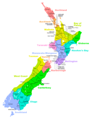
The region is the top tier of local government in New Zealand. There are 16 regions of New Zealand. Eleven are governed by an elected regional council, while five are governed by territorial authorities which also perform the functions of a regional council and thus are known as unitary authorities...
. There are 67 territorial authorities: 13 city councils, 53 district councils, and the Chatham Islands
Chatham Islands
The Chatham Islands are an archipelago and New Zealand territory in the Pacific Ocean consisting of about ten islands within a radius, the largest of which are Chatham Island and Pitt Island. Their name in the indigenous language, Moriori, means Misty Sun...
Council. Six territorial authorities (Auckland Council
Auckland Council
The Auckland Council is the council for the Auckland Region in New Zealand. It began operating on 1 November 2010, combining the functions of the existing regional council and the region's seven previous city and district councils into one "super council" or "super city" governed by a mayor, 20...
, Nelson City Council
Nelson, New Zealand
Nelson is a city on the eastern shores of Tasman Bay, and is the economic and cultural centre of the Nelson-Tasman region. Established in 1841, it is the second oldest settled city in New Zealand and the oldest in the South Island....
, Gisborne
Gisborne Region
The Gisborne Region is an area of northeastern New Zealand governed by the Gisborne District Council, a unitary authority. Its largest settlement, the city also named Gisborne, is located at the northern end of Poverty Bay on the east coast....
, Tasman
Tasman district council
Tasman District Council is the Territorial Local Authority for the Tasman District of New Zealand.-Mayor:The current mayor of Tasman is Richard Kempthorne, who previously served as a Richmond councillor for two terms before being elected Mayor in October 2007.-Councillors:Tasman elects its...
, and Marlborough District Councils and the Chatham Islands Council) also perform the functions of a regional council and thus are known as unitary authorities
Unitary authority
A unitary authority is a type of local authority that has a single tier and is responsible for all local government functions within its area or performs additional functions which elsewhere in the relevant country are usually performed by national government or a higher level of sub-national...
. Territorial authority districts are not subdivisions of regions, and some of them fall within more than one region. Taupo District
Taupo District Council
The Taupo District Council is a local council located in the Central North Island of New Zealand.-Area:The district stretches from the small town of Mangakino in the northwest to the Tongariro National Park in the south, and east into the Kaingaroa Forest, covering 6,970 km2...
has the distinction of straddling the boundaries of four different regions (see below). Regional council areas are based on water catchment
Drainage basin
A drainage basin is an extent or an area of land where surface water from rain and melting snow or ice converges to a single point, usually the exit of the basin, where the waters join another waterbody, such as a river, lake, reservoir, estuary, wetland, sea, or ocean...
areas, whereas territorial authorities are based on community of interest and road access. Regional councils are responsible for the administration of many environmental and public transport matters, while the territorial authorities administer local roading and reserves, sewerage, building consents, the land use and subdivision aspects of resource management, and other local matters. Some activities are delegated to council-controlled organisations.
North Island
| Name | Seat | Area (km2) | Density (/km2) | Region(s) Regions of New Zealand The region is the top tier of local government in New Zealand. There are 16 regions of New Zealand. Eleven are governed by an elected regional council, while five are governed by territorial authorities which also perform the functions of a regional council and thus are known as unitary authorities... |
Notes | |
|---|---|---|---|---|---|---|
| Far North District Far North District The Far North District of New Zealand, as its name suggests, is the northernmost district within New Zealand, consisting of the northern tip of the North Island. The current mayor is Wayne Brown.-Geography:... |
Kaikohe Kaikohe Kaikohe is the central service area for the Far North District of New Zealand, about 260 km from Auckland, situated on State Highway 12 at... |
7,505 | Northland | |||
| Whangarei District Whangarei District The Whangarei District is located in Northland, New Zealand. Whangarei is the principal town and the district seat. Other towns include Hukerenui, Hikurangi, Titoki, Ruakaka and Waipu... |
Whangarei Whangarei Whangarei, pronounced , is the northernmost city in New Zealand and the regional capital of Northland Region. Although commonly classified as a city, it is officially part of the Whangarei District, administered by the Whangarei District Council a local body created in 1989 to administer both the... |
3,314 | Northland | |||
| Kaipara District Kaipara District -Geography:Kaipara District is located in the low hills around the northern shores of the Kaipara Harbour, a large natural harbour open to the Tasman Sea... |
Dargaville Dargaville Dargaville is a town in the North Island of New Zealand. It is situated on the bank of the Northern Wairoa River in the Northland region. The town is located 55 kilometres southwest of Whangarei.... |
3,122 | Northland | |||
| Auckland Auckland Council The Auckland Council is the council for the Auckland Region in New Zealand. It began operating on 1 November 2010, combining the functions of the existing regional council and the region's seven previous city and district councils into one "super council" or "super city" governed by a mayor, 20... |
Auckland Auckland The Auckland metropolitan area , in the North Island of New Zealand, is the largest and most populous urban area in the country with residents, percent of the country's population. Auckland also has the largest Polynesian population of any city in the world... |
5,600 | Unitary authority | |||
| Thames-Coromandel District Thames-Coromandel District The Thames-Coromandel District Council in the North Island of New Zealand is seated in the town of Thames. It is located in the region around the Firth of Thames and Coromandel Peninsula, to the southeast of Auckland... |
Thames Thames, New Zealand Thames is a town at the southwestern end of the Coromandel Peninsula in New Zealand's North Island. It is located on the Firth of Thames close to the mouth of the Waihou River. The town is the seat of the Thames-Coromandel District Council.... |
3,193 | Waikato | |||
| Hauraki District Hauraki District The Hauraki District Council is a municipality in the Waikato Region of New Zealand. The seat of the council is at Paeroa.The area covered by the district extends from the southwest corner of the Firth of Thames southeast towards Te Aroha, although that town lies beyond its boundaries... |
Paeroa Paeroa Paeroa is a small town in New Zealand, in the northern Waikato region of the Thames Valley. Located at the foot of the Coromandel Peninsula, it is close to the junction of the Waihou and Ohinemuri Rivers, 20 kilometres from the coast at the Firth of Thames... |
1,186 | Waikato | |||
| Waikato District Waikato District Waikato District is a territorial authority of New Zealand, in the northern part of Waikato Region, North Island. Waikato District is administered by the Waikato District Council, with headquarters in Ngaruawahia.... |
Ngaruawahia Ngaruawahia Ngāruawāhia is a town in the Waikato region of the North Island of New Zealand. It is located 20 km north-west of Hamilton at the confluence of the Waikato and Waipa Rivers... |
4,506 | Waikato | |||
| Matamata-Piako District Matamata-Piako District The Matamata-Piako District is a local government area in the Waikato region of New Zealand. It lies to the east of the city of Hamilton.The district encompasses the southern end of the Hauraki Plains and much of the Thames Valley, and is bounded in the east by the Kaimai Range... |
Matamata Matamata Matamata is a rural Waikato town in New Zealand with a population of around 12,000 . It is located near the base of the Kaimai Ranges, and is a thriving farming area known for Thoroughbred horse breeding and training pursuits... |
1,755 | Waikato | |||
| Hamilton City Hamilton, New Zealand Hamilton is the centre of New Zealand's fourth largest urban area, and Hamilton City is the country's fourth largest territorial authority. Hamilton is in the Waikato Region of the North Island, approximately south of Auckland... |
Hamilton | 94 | Waikato | |||
| Waipa District Waipa District Waipa District Council in the Waikato region of New Zealand is a municipality that covers Te Awamutu, Cambridge and several small towns. The seat of the council is at Te Awamutu. The district's population at the was , of whom approximately 35% lived in each of the main two towns. The district has... |
Te Awamutu Te Awamutu Te Awamutu is a town in the Waikato in the North Island of New Zealand. It is the council seat of the Waipa District and serves as a service town for the farming communities which surround it... |
1,473 | Waikato | |||
| South Waikato District South Waikato District The South Waikato District is a municipality in the Waikato region of the North Island of New Zealand. It is located between the cities of Hamilton to the north, Rotorua to the east, Taupo to the south and Ruapehu District to the west.... |
Tokoroa Tokoroa Tokoroa is the third-largest town in the Waikato region of the North Island of New Zealand and largest settlement in the South Waikato district. Located 30 km southwest of Rotorua, close to the foot of the Mamaku Ranges, it is mid-way between Taupo and Hamilton on State Highway One... |
1,814 | Waikato | |||
| Otorohanga District | Otorohanga | 2,063 | Waikato | |||
| Waitomo District Waitomo District Waitomo District is a territorial authority in the north of the King Country region in the North Island of New Zealand. A small part of the district, the town of Tiroa, however, lies in the Manawatu-Wanganui region.... |
Te Kuiti Te Kuiti Te Kuiti is a small town in the south of the Waikato region of the North Island of New Zealand. It lies at the junction of State Highways 3 and 30 and on the North Island Main Trunk Railway, 80 km south of Hamilton.... |
3,551 | Waikato (94.87%) Manawatu-Wanganui Manawatu-Wanganui Manawatu-Wanganui is a region in the lower half of the North Island of New Zealand, around the cities of Palmerston North and Whanganui. It is administered by the Horizons Regional Council.-Administration:... (5.13%) |
|||
| Taupo District Taupo District The Taupo District covers 6,350 km² of land, as well as a further 610 km² of lake area, both in Lake Taupo, New Zealand's largest lake, and also in the smaller Lake Rotoaira. The district stretches from the small town of Mangakino in the northwest to the Tongariro National Park in the... |
Taupo Taupo Taupo is a town on the shore of Lake Taupo in the centre of the North Island of New Zealand. It is the seat of the Taupo District Council and lies in the southern Waikato Region.... |
6,955 | Waikato (73.74%) Bay of Plenty Bay of Plenty The Bay of Plenty , often abbreviated to BOP, is a region in the North Island of New Zealand situated around the body of water of the same name... (14.31%) Hawke's Bay (11.26%) Manawatu-Wanganui (0.69%) |
|||
| Western Bay of Plenty District Western Bay of Plenty District 200px|rightThe Western Bay of Plenty District Council is a municipality in the Bay of Plenty Region of New Zealand. The seat of the district council is at Greerton in Tauranga City... |
Greerton, Tauranga City | 2,120 | Bay of Plenty | |||
| Tauranga City Tauranga City Council Tauranga City Council is the local government authority for Tauranga City in New Zealand. It is a territorial authority elected to represent the 116,000 people of Tauranga. The current Mayor of Tauranga is Stuart Crosby... |
Tauranga Tauranga Tauranga is the most populous city in the Bay of Plenty region, in the North Island of New Zealand.It was settled by Europeans in the early 19th century and was constituted as a city in 1963... |
168 | Bay of Plenty | |||
| Opotiki District | Opotiki | 3,098 | Bay of Plenty | |||
| Whakatane District | Whakatane | 4,441 | Bay of Plenty | |||
| Rotorua District | Rotorua | 2,614 | Bay of Plenty (61.52%) Waikato (38.48%) |
|||
| Kawerau District | Kawerau | 22 | Bay of Plenty | |||
| Gisborne District Gisborne Region The Gisborne Region is an area of northeastern New Zealand governed by the Gisborne District Council, a unitary authority. Its largest settlement, the city also named Gisborne, is located at the northern end of Poverty Bay on the east coast.... |
Gisborne Gisborne, New Zealand -Economy:The harbour was host to many ships in the past and had developed as a river port to provide a more secure location for shipping compared with the open roadstead of Poverty Bay which can be exposed to southerly swells. A meat works was sited beside the harbour and meat and wool was shipped... |
8,351 | Unitary authority | |||
| Wairoa District | Wairoa | 4,124 | Hawke's Bay | |||
| Hastings District | Hastings | 5,218 | Hawke's Bay | |||
| Napier City | Napier | 106 | Hawke's Bay | |||
| Central Hawke's Bay District Central Hawke's Bay District Central Hawke's Bay District is a district located in the North Island of New Zealand. It covers an area of 3,327.92 square kilometres with a population of It covers the area from Pukehou in the north to Takapau in the south, and from the western Ruahine Ranges to the Pacific coast in the... |
Waipawa Waipawa Waipawa is the second-largest town in Central Hawke's Bay in the east of the North Island of New Zealand. At the 2001 Census it had a population of 1,872, a change of -2.0 percent since the 1996 census.... |
3,324 | Hawke's Bay | |||
| New Plymouth District New Plymouth District New Plymouth District is one of the districts of New Zealand. It includes the city of New Plymouth and smaller towns such as Inglewood and Waitara.... |
New Plymouth New Plymouth New Plymouth is the major city of the Taranaki Region on the west coast of the North Island of New Zealand. It is named after Plymouth, Devon, England, from where the first English settlers migrated.... |
2,225 | Taranaki | |||
| Stratford District | Stratford | 2,161 | Taranaki (68.13%) Manawatu-Wanganui (31.87%) |
|||
| South Taranaki District South Taranaki District South Taranaki is a territorial authority on the west coast of New Zealand's North Island that contains the towns of Hawera, Manaia, Opunake, Patea, Eltham, and Waverley... |
Hawera | 3,577 | Taranaki | |||
| Ruapehu District Ruapehu District Ruapehu District is a territorial authority near the centre of New Zealand's North Island.It has an area of 6,730.185 square kilometers and a population of 13,569 at the 2006 census .-Features:... |
Taumarunui Taumarunui Taumarunui is a town in the King Country of the central North Island of New Zealand. It is on State Highway 4 and the North Island Main Trunk Railway.... |
6,730 | Manawatu-Wanganui | |||
| Rangitikei District Rangitikei District The Rangitikei District is a Territorial Authority located primarily in the Manawatu-Wanganui Region in the North Island of New Zealand, although a small part, the town of Ngamatea , of it lies in the Hawke's Bay Region... |
Marton Marton, New Zealand Marton is the hub of the Rangitikei district of the Manawatu-Wanganui region of New Zealand's North Island. It is situated 35 kilometres southeast of Wanganui and 40 kilometres northwest of Palmerston North. The population was 4752 .-History:... |
4,476 | Manawatu-Wanganui (86.37%) Hawke's Bay (13.63%) |
|||
| Wanganui District | Wanganui Wanganui Whanganui , also spelled Wanganui, is an urban area and district on the west coast of the North Island of New Zealand. It is part of the Manawatu-Wanganui region.... |
2,372 | Manawatu-Wanganui | |||
| Manawatu District Manawatu District The Manawatu District is a district in the Manawatu-Wanganui Region in the North Island of New Zealand.-Location:"The Manawatu", as it is usually called, is located in the southwest of the island, close to the river which shares its name... |
Feilding | 2,628 | Manawatu-Wanganui | |||
| Palmerston North City | Palmerston North | 337 | Manawatu-Wanganui | |||
| Tararua District Tararua District The Tararua District lies near the south-east corner of New Zealand's North Island. Created in 1989, it was named after the Tararua Range, which forms much of its western boundary. It has a population of and an area of 4,360.56 km².... |
Dannevirke Dannevirke Dannevirke , is a rural service town in the Manawatu-Wanganui Region of the North Island, New Zealand. It is the major town of the administrative Tararua District, the easternmost of the districts in which the Regional Council has responsibilities... |
4,367 | Manawatu-Wanganui (98.42%) Wellington Wellington Region The Wellington region of New Zealand occupies the southern end of the North Island.-Governance:The official Wellington Region, as administered by the Wellington Regional Council covers the conurbation around the capital city, Wellington, and the cities of Lower Hutt, Porirua, and Upper Hutt, each... (1.58%) |
|||
| Horowhenua District Horowhenua District Horowhenua is a district on the west coast of the North Island of New Zealand. It forms part of the Manawatu-Wanganui Region.Located north of Wellington and Kapiti, the district stretches from slightly north of the town of Otaki in the south to just south of Himatangi in the north, and from the... |
Levin Levin, New Zealand Levin is a town in the Manawatu-Wanganui region of New Zealand, and is the largest town in the Horowhenua district. It is 90 kilometres north of Wellington, 50 kilometres south of Palmerston North, and two kilometres to the east of Lake Horowhenua.... |
1,066 | Manawatu-Wanganui | |||
| Masterton District | Masterton | 2,298 | Wellington | |||
| Kapiti Coast District Kapiti Coast District The Kapiti Coast District is a local government district in the lower North Island of New Zealand 50 km north of Wellington.The district is named after Kapiti Island a prominent landmark 5 km offshore. The population of the district is concentrated in the chain of coastal settlements... |
Paraparaumu Paraparaumu Paraparaumu is a town in the south-western North Island of New Zealand. It lies in the Kapiti Coast, 50 kilometres north of the nation's capital city, Wellington.... |
733 | Wellington | |||
| Carterton District | Carterton | 1,181 | Wellington | |||
| South Wairarapa District South Wairarapa District South Wairarapa District is at the south-east tip of the North Island of New Zealand.-Introduction:South Wairarapa includes three towns and several localities that have a wide range of economic activity, natural features, and visitor attractions, only a few of which are noted here. Martinborough is... |
Martinborough Martinborough Martinborough is a town in South Wairarapa, a district in the Wellington region on the North Island of New Zealand. It is 65 kilometres east of Wellington and 35 kilometres south-west of Masterton... |
2,452 | Wellington | |||
| Upper Hutt City | Upper Hutt | 542 | Wellington | |||
| Porirua City | Porirua | 182 | Wellington | |||
| Hutt City | Lower Hutt | 377 | Wellington | |||
| Wellington City Wellington City Wellington City Council is a territorial authority in the Wellington region of New Zealand. Wellington city extends as far north as Linden, and includes the rural areas of Makara and Ohariu. It is New Zealand's third-largest city, behind Auckland and Christchurch.Wellington attained city status in... |
Wellington | 289 | Wellington |
South Island
| Name | Seat | Area (km2) | Density (per km2) | Region(s) Regions of New Zealand The region is the top tier of local government in New Zealand. There are 16 regions of New Zealand. Eleven are governed by an elected regional council, while five are governed by territorial authorities which also perform the functions of a regional council and thus are known as unitary authorities... |
Notes | |
|---|---|---|---|---|---|---|
| Tasman District Tasman district council Tasman District Council is the Territorial Local Authority for the Tasman District of New Zealand.-Mayor:The current mayor of Tasman is Richard Kempthorne, who previously served as a Richmond councillor for two terms before being elected Mayor in October 2007.-Councillors:Tasman elects its... |
Richmond Richmond, New Zealand Richmond, the seat of the Tasman District Council, lies 13 km south of Nelson in the South Island of New Zealand, close to the southern extremity of Tasman Bay... |
9,786 | unitary authority | |||
| Nelson City Nelson, New Zealand Nelson is a city on the eastern shores of Tasman Bay, and is the economic and cultural centre of the Nelson-Tasman region. Established in 1841, it is the second oldest settled city in New Zealand and the oldest in the South Island.... |
Nelson | 445 | unitary authority | |||
| Marlborough District | Blenheim Blenheim, New Zealand Blenheim is the most populous town in the region of Marlborough, in the north east of the South Island of New Zealand, and the seat of the regional council. It has a population of The area which surrounds the town is well known as a centre of New Zealand's wine industry... |
12,484 | unitary authority | |||
| Buller District Buller District 200px|rightBuller District, administered by the Buller District Council is an administrative region in the West Coast Region of New Zealand. It covers Westport, Karamea, Reefton and Inangahua Junction. Its land area is 7,953.12 km²... |
Westport Westport, New Zealand -Economy:Economic activity is based around fishing, coal mining and dairy farming. Historically, gold mining was a major industry, and coal mining was much more extensive than today . However, the region still is home to New Zealand's largest opencast mining operation in Stockton... |
7,950 | West Coast West Coast, New Zealand The West Coast is one of the administrative regions of New Zealand, located on the west coast of the South Island, and is one of the more remote and most sparsely populated areas of the country. It is made up of three districts: Buller, Grey and Westland... |
|||
| Grey District Grey District Grey District Council in the West Coast region of New Zealand is a municipality that covers Greymouth, Runanga, Blackball, Cobden and settlements along the Grey River. It has a land area of 3,516.48 km²... |
Greymouth | 3,516 | West Coast | |||
| Westland District Westland District Westland District is a territorial authority on the west coast of New Zealand's South Island. Its population is - Government :The Westland District is governed by an elected Council, headed by an elected Mayor. The Mayor is elected at large. The current Mayor is Maureen Pugh. Councillors are... |
Hokitika | 11,870 | West Coast | |||
| Kaikoura District | Kaikoura | 2,050 | Canterbury | |||
| Hurunui District Hurunui District The Hurunui District is a political district on the east coast of New Zealand's South Island, north of Christchurch, New Zealand. It forms part of the Canterbury region and stretches from the east coast to the main divide. Its land area is .... |
Amberley Amberley, New Zealand Amberley is a town located in the Hurunui District of north Canterbury, on the east coast of the South Island of New Zealand. It is located on State Highway 1 approximately 50 km north of Christchurch... |
8,661 | Canterbury | |||
| Selwyn District Selwyn District The Selwyn District is a predominantly rural area in central Canterbury, on the east coast of New Zealand's South Island. It is named after the Selwyn River, which is in turn named after Bishop George Selwyn, the first Anglican bishop of New Zealand who, in 1843 and 1844, travelled the length of... |
Rolleston Rolleston, New Zealand Rolleston is a town in the Selwyn District of Canterbury, New Zealand.It is located next to State Highway 1, 22 km south-west of Christchurch on the Canterbury Plains in the South Island of New Zealand. The town uses the slogan "The Town of the Future"... |
6,557 | Canterbury | |||
| Waimakariri District Waimakariri District The Waimakariri District is a political district of New Zealand, located in the South Island, on the eastern coast of north Canterbury. It is north of Christchurch and the Waimakariri River and is a part of the greater Canterbury region. The name is Māori for cold river.The district was established... |
Rangiora | 2,216 | Canterbury | |||
| Christchurch City Christchurch City Council The Christchurch City Council is the local government authority for Christchurch in New Zealand. It is a territorial authority elected to represent the people of Christchurch. Since 2007, the Mayor of Christchurch is Bob Parker, who stood as an independent candidate... |
Christchurch Christchurch Christchurch is the largest city in the South Island of New Zealand, and the country's second-largest urban area after Auckland. It lies one third of the way down the South Island's east coast, just north of Banks Peninsula which itself, since 2006, lies within the formal limits of... |
1,610 | Canterbury | |||
| Ashburton District | Ashburton | 6,208 | Canterbury | |||
| Mackenzie District Mackenzie District Mackenzie District is a political district in New Zealand's South Island. It is part of the larger Canterbury Region.-Principal settlements:*Fairlie*Twizel*Cave*Mount Cook Village*Albury*TekapoAlso*Burkes Pass-Geography:See Mackenzie Basin,... |
Fairlie | 7,442 | Canterbury | |||
| Timaru District | Timaru | 2,726 | Canterbury | |||
| Waimate District | Waimate | 3,577 | Canterbury | |||
| Waitaki District Waitaki District The Waitaki district, in the Canterbury and Otago regions of New Zealand, straddles the traditional border between the two regions, the Waitaki River. It has a land area of 7,151.94 km² , divided 59.28% to Canterbury Region and 40.72% to Otago Region. It is the only district on the South... |
Oamaru Oamaru Oamaru , the largest town in North Otago, in the South Island of New Zealand, is the main town in the Waitaki District. It is 80 kilometres south of Timaru and 120 kilometres north of Dunedin, on the Pacific coast, and State Highway 1 and the railway Main South Line connects it to both... |
7,212 | Canterbury (59.61%) Otago Otago Otago is a region of New Zealand in the south of the South Island. The region covers an area of approximately making it the country's second largest region. The population of Otago is... (40.39%) |
|||
| Queenstown-Lakes District | Queenstown Queenstown, New Zealand Queenstown is a resort town in Otago in the south-west of New Zealand's South Island. It is built around an inlet called Queenstown Bay on Lake Wakatipu, a long thin Z-shaped lake formed by glacial processes, and has spectacular views of nearby mountains.... |
9,368 | Otago | |||
| Central Otago District | Alexandra Alexandra, New Zealand Alexandra is a town in the Central Otago district of the Otago region of New Zealand. It is located on the banks of the Clutha River , on State Highway 8, 188 km by road from Dunedin and 33 km south of Cromwell.At the time of the 2006 census, the permanent population was 4,827, an... |
9,966 | Otago | |||
| Dunedin City Dunedin Dunedin is the second-largest city in the South Island of New Zealand, and the principal city of the Otago Region. It is considered to be one of the four main urban centres of New Zealand for historic, cultural, and geographic reasons. Dunedin was the largest city by territorial land area until... |
Dunedin | 3,340 | Otago | |||
| Clutha District Clutha District The Clutha District is an administrative district of southern New Zealand, with its headquarters in the Otago town of Balclutha. The Clutha District has a land area of 6,362.86 km² and a 2006 census population of 16,839 usual residents... |
Balclutha Balclutha, New Zealand Balclutha is a town in Otago, it lies towards the end of the Clutha River on the east coast of the South Island of New Zealand. It is about halfway between Dunedin and Invercargill on the Main South Line railway, State Highway 1 and the Southern Scenic Route... |
6,406 | Otago | |||
| Southland District Southland District Southland District is a territorial authority in the South Island of New Zealand. Southland District covers the majority of the land area of Southland Region, although the region also covers Gore District, Invercargill City and adjacent territorial waters... |
Invercargill Invercargill Invercargill is the southernmost and westernmost city in New Zealand, and one of the southernmost cities in the world. It is the commercial centre of the Southland region. It lies in the heart of the wide expanse of the Southland Plains on the Oreti or New River some 18 km north of Bluff,... |
32,605 | Southland Southland Region Southland is New Zealand's southernmost region and is also a district within that region. It consists mainly of the southwestern portion of the South Island and Stewart Island / Rakiura... |
Includes Stewart Island/Rakiura Stewart Island/Rakiura Stewart Island/Rakiura is the third-largest island of New Zealand. It lies south of the South Island, across Foveaux Strait. Its permanent population is slightly over 400 people, most of whom live in the settlement of Oban.- History and naming :... (see below) and Solander Islands Solander Islands The Solander Islands are a small chain of uninhabited volcanic islets lying at , close to the western end of the Foveaux Strait in southern New Zealand... . |
||
| Gore District | Gore | 1,251 | Southland | |||
| Invercargill City | Invercargill | 491 | Southland |
Stewart Island/Rakiura
| Name | Seat | Area (km2) | Population | Region |
|---|---|---|---|---|
| Part of Southland District | Invercargill, South Island | 1746 | 402 | Southland |
Chatham Islands
- Chatham Islands TerritoryChatham IslandsThe Chatham Islands are an archipelago and New Zealand territory in the Pacific Ocean consisting of about ten islands within a radius, the largest of which are Chatham Island and Pitt Island. Their name in the indigenous language, Moriori, means Misty Sun...
is a district governed by the Chatham Islands Council, a unitary authority.
Other islands
There are a number of islands where the Minister of Local Government is the territorial authority, two of which have a 'permanent population and/or permanent buildings and structures.' The main islands are listed below (population according to 2001 census in parenthesis):- Mayor Island/TuhuaMayor Island/TuhuaMayor Island is a dormant shield volcano located off the Bay of Plenty coast of New Zealand's North Island. It lies north of Tauranga and covers . The island is quite steep along its coast and rises to about sea level. A saddle about deep separates it from the North Island, while the other...
(3) - Motiti IslandMotiti IslandMotiti Island is located off the Bay of Plenty coast of New Zealand's North Island. It is north-east of Tauranga and north-east of Papamoa. There were 18 homes occupied by 27 people on the island in the 2006 Census....
(30) - Whakaari/White IslandWhakaari/White IslandWhakaari/White Island is an active andesite stratovolcano, situated from the east coast of the North Island of New Zealand, in the Bay of Plenty. The nearest mainland towns are Whakatane and Tauranga....
- Moutohora Island
- Bare IslandBare Island, New ZealandBare Island, also known as Motu-O-Kura , is a small island located in the Pacific Ocean in the southern Hawke's Bay on the eastern North Island of New Zealand...
In addition, seven of the nine groups of the New Zealand Outlying Islands
New Zealand Outlying Islands
The New Zealand outlying islands comprise nine island groups, located in the subtropics and subantarctic, which are part of New Zealand but lie outside of the New Zealand continental shelf. Although considered as integral parts of New Zealand, seven of the nine island groups are not part of any...
are outside of any territorial authority:
- Kermadec IslandsKermadec IslandsThe Kermadec Islands are a subtropical island arc in the South Pacific Ocean northeast of New Zealand's North Island, and a similar distance southwest of Tonga...
(3) - Three Kings IslandsThree Kings IslandsThe Three Kings Islands or Manawa Islands are a group of 13 islands about northwest of Cape Reinga, the northernmost point of the North Island of New Zealand, where the South Pacific Ocean and Tasman Sea converge. They measure about 4.86 km² in area...
- Bounty IslandsBounty IslandsThe Bounty Islands at are a small group of 13 granite islets and numerous rocks, with a combined area of , in the south Pacific Ocean that are territorially part of New Zealand. They are located between 47°44'35" and 47°46'10" S, and 179°01' and 179°04'20" E, southeast of the South Island of New...
- The SnaresThe SnaresSnares Islands/Tini Heke is a small island group situated approximately 200 kilometres south of New Zealand's South Island and to the south-south-west of Stewart Island/Rakiura. The Snares consist of the main island North East Island and the smaller Broughton Island as well as the somewhat...
- Antipodes IslandsAntipodes IslandsThe Antipodes Islands are inhospitable volcanic islands to the south of—and territorially part of—New Zealand...
- Auckland IslandsAuckland IslandsThe Auckland Islands are an archipelago of the New Zealand Sub-Antarctic Islands and include Auckland Island, Adams Island, Enderby Island, Disappointment Island, Ewing Island, Rose Island, Dundas Island and Green Island, with a combined area of...
- Campbell Islands
1989 local government reforms
For many decades until the local government reforms of 1989, a borough with more than 20,000 people could be proclaimed a city. The boundaries of councils tended to follow the edge of the built-up area, so little distinction was made between the urban area and the local government area.New Zealand’s local government structural arrangements were significantly reformed by the Local Government Commission in 1989 when approximately 700 councils and special purpose bodies were amalgamated to create 87 new local authorities. Regional councils were reduced in number from 20 to 13, territorial authorities (city/district councils) from 200 to 75, and special purpose bodies from over 400 to 7. The new district and city councils were generally much larger and most covered substantial areas of both urban and rural land. Many places that once had a city council were now being administered by a district council.
As a result, the term "city" began to take on two meanings.
The word "city" came to be used in a less formal sense to describe major urban areas independent of local body boundaries. This informal usage is jealously guarded. Gisborne, for example, adamantly described itself as the first city in the world to see the new millennium. Gisborne is administered by a district council, but its status as a city is not generally disputed.
Under the current law the minimum population for a new city is 50,000.
Changes since 1989
Since the 1989 reorganisations, there have been few major reorganisations or status changes in local government. Incomplete list:- 1991: Invercargill re-proclaimed a city.
- 1992: Nelson-Marlborough Regional Council abolished by a Local Government Amendment Act. Kaikoura DistrictKaikouraKaikoura is a town on the east coast of the South Island of New Zealand. It is located on State Highway 1 180 km north of Christchurch.Kaikoura became the first local authority to reach the Green Globe tourism certification standard....
was transferred to the Canterbury Region, and Nelson CityNelson, New ZealandNelson is a city on the eastern shores of Tasman Bay, and is the economic and cultural centre of the Nelson-Tasman region. Established in 1841, it is the second oldest settled city in New Zealand and the oldest in the South Island....
and Tasman and Marlborough districts became unitary authorities. - 1995: The Chatham Islands CountyChatham IslandsThe Chatham Islands are an archipelago and New Zealand territory in the Pacific Ocean consisting of about ten islands within a radius, the largest of which are Chatham Island and Pitt Island. Their name in the indigenous language, Moriori, means Misty Sun...
was dissolved and reconstituted by a specific Act of Parliament as the "Chatham Islands Territory", with powers similar to those of territorial authorities and some functions similar to those of a regional council. - 2004: Tauranga became a city again on 1 March.
- 2006: Banks Peninsula District merged into Christchurch City as a result of 2005 referendum.
Reports on completed reorganisation proposals since 1999 are available on the Local Government Commission's site (link below).
2007–2009 Royal Commission on Auckland Governance
On 26 March 2009, the Royal Commission on Auckland GovernanceRoyal Commission on Auckland Governance
The Royal Commission on Auckland Governance was established by the New Zealand Government to investigate the local government arrangements of Auckland....
recommended the Rodney, North Shore, Waitakere, Auckland City, Manukau, Papakura and Franklin territorial councils and the Auckland Regional Council be abolished and the entire Auckland region to be amalgamated into one "supercity". The area would consist of one city council (with statutory provision for three Maori councillors), four urban local councils, and two rural local councils:
- Rodney local council would lose Orewa, Dairy Flat, and Whangaparaoa but retain the remainder of the current Rodney District. The split areas as well as the current North Shore City would form a Waitemata local council.
- Waitakere local council would consist of the current Waitakere City as well as the Avondale area.
- Tamaki Makaurau would consist of the current Auckland City and Otahuhu (excluding CBD)
- Manukau local council would consist of the urban parts of the current Manukau City and of the Papakura District.
- Hunua local council would consist of the entire Franklin District, much of which is currently in the Waikato Region, along with rural areas of the current Papakura District and Manukau City.
- The entire Papakura District would be dissolved between urban and rural councils.
Central Government response
The National-led Government responded within about a week. Its proposal, which will go to a Select Committee, has the supercity and many community boards but no local councils and for the first election no separate seats for Maori.Public response
Public reaction to the Royal Commission report was mixed, especially in regards to the Government's amended proposal. Auckland Mayor John BanksJohn Banks (New Zealand)
John Archibald Banks, CNZM QSO is a New Zealand politician. He served as Mayor of Auckland City for two terms, from 2001 to 2004, and from 2007 to 2010...
supported the amended merger plans.
Criticism of the amended proposal came largely from residents in Manukau, Waitakere and North Shore Cities. In addition, Maori Affairs Minister Pita Sharples
Pita Sharples
Pita Russell Sharples, CBE, , a Māori academic and politician, currently co-leads the Māori Party. He currently is the member for Tamaki Makaurau in New Zealand's Parliament.-Early life:...
spoke against the exclusion of the Maori seats, as recommended by the Royal Commission. Opposition Leader Phil Goff
Phil Goff
Philip Bruce Goff is the current Leader of the Opposition and the Leader of the New Zealand Labour Party. During the Fifth Labour Government, he served in a number of ministerial portfolios, including Minister of Defence of New Zealand, Minister of Corrections, Minister of Foreign Affairs and...
called for a referendum on the issue.
See also
- Regions of New ZealandRegions of New ZealandThe region is the top tier of local government in New Zealand. There are 16 regions of New Zealand. Eleven are governed by an elected regional council, while five are governed by territorial authorities which also perform the functions of a regional council and thus are known as unitary authorities...
- Districts of New ZealandDistricts of New ZealandA district in New Zealand is a territorial authority area governed by a District Council as a second-tier local government unit. They were formed as a result of local government reforms in 1989.-Districts:There are currently 53 districts:*Ashburton District...
- List of cities in New Zealand
- List of former territorial authorities in New Zealand
- Local Government Act 1974 (New Zealand)
- Local Government Act 2002 (New Zealand)
- Local Government New ZealandLocal Government New ZealandLocal Government New Zealand is the organisation that represents the national interests of all 85 councils of New Zealand. These include regional councils, unitary authorities, district councils and city councils....
External links and sources
- Local Councils website (maintained by the Department of Internal Affairs)
- Local Government Services at the Department of Internal Affairs site (includes the Local Government Directory at the bottom of the page)
- Local Government Commission site
- Local Government Online Limited site (portal site owned by the Society of Local Government Managers and the Association of Local Government Information Management)
- Local Government New Zealand region and district boundaries– North Island
- Local Government New Zealand region and district boundaries– South Island
- Statistics New Zealand clickable map for local body and area unit detail over all NZ