
Taygetus
Encyclopedia
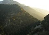
Mount Taygetus, Taugetus, or Taigetus is a mountain range
in the Peloponnese
peninsula in Southern Greece
. The name is one of the oldest recorded in Europe, appearing in the Odyssey
. In classical mythology, it was associated with the nymph Taygete
. During Byzantine
times and up until the 19th century, the mountain was also known as Pentedaktylos (Greek for five-fingered, a common name during that period).
, its southernmost extremity. It contains the tallest mountain in the Peloponnese, the Profitis Ilias summit, reaching 2407 m; this is probably the classical Mount Taleton mentioned by Pausanias. The summit is an ultra prominent peak
. It is prominent above the Isthmus of Corinth
, which separating the Peloponnese from mainland Greece, rises only to approximately 60 m. Numerous creeks wash down from the mountains and the Evrotas river has some of its headwaters in the northern part of the range.
 Taygetus overlooks the cities of Sparti and Kalamata
, whose skyline it dominates. The mountain range lies within the prefectures of Arcadia
, Laconia
and Messenia
. Taygetus is crossed by Greek National Road 82
, which links Kalamata to Sparti
and separates Northern Taygetus from the Central Range. The Rindomo Gorge separates the Central Range from Southern Taygetos. The section of Taygetus that forms the backbone of the Mani Peninsula
is also known as Saggias, and is often not considered part of Taygetus. The central part of the mountain range is commonly called "Skoteini Plevra", which means "the dark side" because the villages located there do not receive as much sunshine in the early morning and the late afternoon hours.
and run generally in an east-west direction are of the folded type
generated by collision of the northward-moving African Plate
with the Eurasian Plate
. Where the northern edge of the African Plate is being subducted
in an irregular line a second orogeny
occurs that is not entirely understood. The mountains of Italy
and Greece
are a combination of Folded Mountains and Fault-block mountain
s running in a northwest-southeast direction.
The Hellenic Subduction carries the leading edge of the African Plate under the Aegean Sea Plate
at the Hellenic Trench
. It follows an arc around the outer edge of the Peloponnese and Crete. The subduction on the west is to the northeast, on the east to the northwest, and north in the center. The average direction is N 21° E. In the islands and southern Greece a fault-block mountain
orogeny prevails due to a double set of crustal movements. On the one hand the Aegean Sea Plate is being raised by the subduction. On the other hand, north-south extensional movements, yet unexplained, are pulling the plate apart, creating normal extensional fault
s and generating a parallel sequence of horsts and graben
s, or rift valley
s, running in a north-south direction.
Mount Taygetus is a limestone horst bordering the Eurotas Rift Valley. Below its eastern face is the Sparta fault, a normal fault striking perpendicular to the direction of extension. Footwall scarp
s are visible on the eastern side of Taygetus at the base of its spurs. They result from sudden slippages of the hanging wall in the direction of the dip, causing earthquakes. Single earthquakes result in 1-12 m of scarp. The Sparta fault is zig-zag in strike, varying between N 170° E and N 140° E. The maximum slippage has been 10-12 m in three increments. The earthquake of 464 BC, which levelled Sparta, resulted from a slippage of 3-4 m over a length of 20 km of the fault. The slip rate has been about 1 mm per year suggesting an average interval between earthquakes of 3000 years.
(Abies cephallonica) and black pine
(Pinus nigra). Devastating fires in 2005 and 2007 consumed much of the forests on the central west slopes, and only about half remain.
times. The site of Arkina, near the village of Arna
, contains three beehive tombs and is still unexplored. Taygetus was important as one of Sparta's natural defenses. The Sparta
ns threw criminals and "unfit" (weak, sickly, deformed
, or mentally retarded
) infant
s into a chasm of Taygetus known as Ceadas (Κεάδας) or Caeadas (Greek
: Καιάδας). In antiquity
, male Sparta
n newborns were abandoned there if deemed unfit after examination for vitality. Recent evidence, found by the University of Athens, discovered remains of adult individuals which appeared to confirm that Ceadas was also, or mainly, a place of punishment for criminals, traitors and captives. During the era of barbarian invasions, Taygetus served as a shelter for the native population. Many of the villages in its slopes date from this period. In Medieval times
, the citadel and monastery of Mystras
was built on the steep slopes, and became a center of Byzantine civilizations and served as capital of the Byzantine Empire
. Mystras remains occupied by a tiny religious community. The buildings are remarkably well-preserved and a major tourist attraction in the region.
, the Sun, to whom horses were sacrificed. As it is probably this peak that was later named "Profitis Ilias", it supports the hypothesis that the cult of the Prophet Elias replaced that of Helios on mountaintops; but Taleton was also dedicated to Zeus
, a more common association.
range to the east, while the view towards the west includes Kalamata
and the eastern half of Messenia. Most of the southwestern part of Arcadia can also be seen from the summit.
Mountain range
A mountain range is a single, large mass consisting of a succession of mountains or narrowly spaced mountain ridges, with or without peaks, closely related in position, direction, formation, and age; a component part of a mountain system or of a mountain chain...
in the Peloponnese
Peloponnese
The Peloponnese, Peloponnesos or Peloponnesus , is a large peninsula , located in a region of southern Greece, forming the part of the country south of the Gulf of Corinth...
peninsula in Southern Greece
Greece
Greece , officially the Hellenic Republic , and historically Hellas or the Republic of Greece in English, is a country in southeastern Europe....
. The name is one of the oldest recorded in Europe, appearing in the Odyssey
Odyssey
The Odyssey is one of two major ancient Greek epic poems attributed to Homer. It is, in part, a sequel to the Iliad, the other work ascribed to Homer. The poem is fundamental to the modern Western canon, and is the second—the Iliad being the first—extant work of Western literature...
. In classical mythology, it was associated with the nymph Taygete
Taygete
In Greek mythology, Taygete was a nymph, one of the Pleiades according to Apollodorus and a companion of Artemis, in her archaic role as potnia theron, "Mistress of the animals". Mount Taygetos in Laconia, dedicated to the Goddess, was her haunt....
. During Byzantine
Byzantine Empire
The Byzantine Empire was the Eastern Roman Empire during the periods of Late Antiquity and the Middle Ages, centred on the capital of Constantinople. Known simply as the Roman Empire or Romania to its inhabitants and neighbours, the Empire was the direct continuation of the Ancient Roman State...
times and up until the 19th century, the mountain was also known as Pentedaktylos (Greek for five-fingered, a common name during that period).
Physical
The Taygetus Massif is about 100 km long, extending from the center of the Peloponnese to Cape MatapanCape Matapan
Cape Tainaron , also known as Cape Matapan , is situated at the end of the Mani, Laconia, Greece. Cape Matapan is the southernmost point of mainland Greece. It separates the Messenian Gulf in the west from the Laconian Gulf in the east.-History:...
, its southernmost extremity. It contains the tallest mountain in the Peloponnese, the Profitis Ilias summit, reaching 2407 m; this is probably the classical Mount Taleton mentioned by Pausanias. The summit is an ultra prominent peak
Ultra prominent peak
An ultra prominent peak, or Ultra for short, is a mountain with a topographic prominence of or more. There are a total of roughly 1,524 such peaks in the world. Some are famous even to non-climbers, such as Mount Everest, Aconcagua, and Mount McKinley , while others are much more obscure...
. It is prominent above the Isthmus of Corinth
Isthmus of Corinth
The Isthmus of Corinth is the narrow land bridge which connects the Peloponnese peninsula with the rest of the mainland of Greece, near the city of Corinth. The word "isthmus" comes from the Ancient Greek word for "neck" and refers to the narrowness of the land. The Isthmus was known in the ancient...
, which separating the Peloponnese from mainland Greece, rises only to approximately 60 m. Numerous creeks wash down from the mountains and the Evrotas river has some of its headwaters in the northern part of the range.
Political
Kalamata
Kalamata is the second-largest city of the Peloponnese in southern Greece. The capital and chief port of the Messenia prefecture, it lies along the Nedon River at the head of the Messenian Gulf...
, whose skyline it dominates. The mountain range lies within the prefectures of Arcadia
Arcadia
Arcadia is one of the regional units of Greece. It is part of the administrative region of Peloponnese. It is situated in the central and eastern part of the Peloponnese peninsula. It takes its name from the mythological character Arcas. In Greek mythology, it was the home of the god Pan...
, Laconia
Laconia
Laconia , also known as Lacedaemonia, is one of the regional units of Greece. It is part of the region of Peloponnese. It is situated in the southeastern part of the Peloponnese peninsula. Its administrative capital is Sparti...
and Messenia
Messenia
Messenia is a regional unit in the southwestern part of the Peloponnese region, one of 13 regions into which Greece has been divided by the Kallikratis plan, implemented 1 January 2011...
. Taygetus is crossed by Greek National Road 82
Greek National Road 82
Greek National Road 82 is a west to east highway linking Pylos with the GR-9/E55, Kalamata and downtown Sparta with GR-37/E???. The highway begins in downtown Pylos and runs through the southwestern part of Messenia and through curvy roads and through Lykodimos and intersects with a road linking...
, which links Kalamata to Sparti
Sparti (municipality)
Sparti is a municipality of Laconia, Greece. It lies at the site of ancient Sparta. The population in 2001 was 38,079, of whom 15,828 lived in the town itself.-History:...
and separates Northern Taygetus from the Central Range. The Rindomo Gorge separates the Central Range from Southern Taygetos. The section of Taygetus that forms the backbone of the Mani Peninsula
Mani Peninsula
The Mani Peninsula , also long known as Maina or Maïna, is a geographical and cultural region in Greece. Mani is the central peninsula of the three which extend southwards from the Peloponnese in southern Greece. To the east is the Laconian Gulf, to the west the Messenian Gulf...
is also known as Saggias, and is often not considered part of Taygetus. The central part of the mountain range is commonly called "Skoteini Plevra", which means "the dark side" because the villages located there do not receive as much sunshine in the early morning and the late afternoon hours.
Geology
The mountains of southern Europe that fringe the Mediterranean SeaMediterranean Sea
The Mediterranean Sea is a sea connected to the Atlantic Ocean surrounded by the Mediterranean region and almost completely enclosed by land: on the north by Anatolia and Europe, on the south by North Africa, and on the east by the Levant...
and run generally in an east-west direction are of the folded type
Fold (geology)
The term fold is used in geology when one or a stack of originally flat and planar surfaces, such as sedimentary strata, are bent or curved as a result of permanent deformation. Synsedimentary folds are those due to slumping of sedimentary material before it is lithified. Folds in rocks vary in...
generated by collision of the northward-moving African Plate
African Plate
The African Plate is a tectonic plate which includes the continent of Africa, as well as oceanic crust which lies between the continent and various surrounding ocean ridges.-Boundaries:...
with the Eurasian Plate
Eurasian Plate
The Eurasian Plate is a tectonic plate which includes most of the continent of Eurasia , with the notable exceptions of the Indian subcontinent, the Arabian subcontinent, and the area east of the Chersky Range in East Siberia...
. Where the northern edge of the African Plate is being subducted
Subduction
In geology, subduction is the process that takes place at convergent boundaries by which one tectonic plate moves under another tectonic plate, sinking into the Earth's mantle, as the plates converge. These 3D regions of mantle downwellings are known as "Subduction Zones"...
in an irregular line a second orogeny
Orogeny
Orogeny refers to forces and events leading to a severe structural deformation of the Earth's crust due to the engagement of tectonic plates. Response to such engagement results in the formation of long tracts of highly deformed rock called orogens or orogenic belts...
occurs that is not entirely understood. The mountains of Italy
Italy
Italy , officially the Italian Republic languages]] under the European Charter for Regional or Minority Languages. In each of these, Italy's official name is as follows:;;;;;;;;), is a unitary parliamentary republic in South-Central Europe. To the north it borders France, Switzerland, Austria and...
and Greece
Greece
Greece , officially the Hellenic Republic , and historically Hellas or the Republic of Greece in English, is a country in southeastern Europe....
are a combination of Folded Mountains and Fault-block mountain
Fault-block mountain
Fault-block landforms are formed when large areas of bedrock are widely broken up by faults creating large vertical displacements of continental crust....
s running in a northwest-southeast direction.
The Hellenic Subduction carries the leading edge of the African Plate under the Aegean Sea Plate
Aegean Sea Plate
The Aegean Sea Plate is a small tectonic plate located in the eastern Mediterranean Sea under southern Greece and far western Turkey. Its southern edge is a subduction zone south of Crete, where the African Plate is being swept under the Aegean Sea Plate...
at the Hellenic Trench
Hellenic Trench
The Hellenic Trench is a hemispherical-scale long narrow depression in the Ionian Sea.The hadal zone of the Hellenic trench is roughly to 5,300 metres deep. The names of the three major parts of the Hellenic trench are: Matapan Deep System or Matapan–Vavilov Deep, roughly , the...
. It follows an arc around the outer edge of the Peloponnese and Crete. The subduction on the west is to the northeast, on the east to the northwest, and north in the center. The average direction is N 21° E. In the islands and southern Greece a fault-block mountain
Fault-block mountain
Fault-block landforms are formed when large areas of bedrock are widely broken up by faults creating large vertical displacements of continental crust....
orogeny prevails due to a double set of crustal movements. On the one hand the Aegean Sea Plate is being raised by the subduction. On the other hand, north-south extensional movements, yet unexplained, are pulling the plate apart, creating normal extensional fault
Extensional fault
An extensional fault is a fault that vertically thins and horizontally extends portions of the Earth's crust and/or lithosphere. In most cases such a fault is also a normal fault, but may be rotated to have a shallower geometry normally associated with a thrust fault...
s and generating a parallel sequence of horsts and graben
Graben
In geology, a graben is a depressed block of land bordered by parallel faults. Graben is German for ditch. Graben is used for both the singular and plural....
s, or rift valley
Rift valley
A rift valley is a linear-shaped lowland between highlands or mountain ranges created by the action of a geologic rift or fault. This action is manifest as crustal extension, a spreading apart of the surface which is subsequently further deepened by the forces of erosion...
s, running in a north-south direction.
Mount Taygetus is a limestone horst bordering the Eurotas Rift Valley. Below its eastern face is the Sparta fault, a normal fault striking perpendicular to the direction of extension. Footwall scarp
Scarp
-Landforms and geology:* Cliff, a significant vertical, or near vertical, rock exposure* Escarpment, a steep slope or long cliff that occurs from erosion or faulting and separates two relatively level areas of differing elevations...
s are visible on the eastern side of Taygetus at the base of its spurs. They result from sudden slippages of the hanging wall in the direction of the dip, causing earthquakes. Single earthquakes result in 1-12 m of scarp. The Sparta fault is zig-zag in strike, varying between N 170° E and N 140° E. The maximum slippage has been 10-12 m in three increments. The earthquake of 464 BC, which levelled Sparta, resulted from a slippage of 3-4 m over a length of 20 km of the fault. The slip rate has been about 1 mm per year suggesting an average interval between earthquakes of 3000 years.
Ecology
The slopes of Taygetus are heavily forested, primarily with Greek firGreek Fir
Greek Fir is a fir native to the mountains of Greece, primarily in the Peloponnesos and the island of Kefallonia, intergrading with the closely related Bulgarian Fir further north in the Pindus mountains of northern Greece. It is a medium-size evergreen coniferous tree growing to – rarely – tall...
(Abies cephallonica) and black pine
Black Pine
Several trees are referred to as black pine:* The European Black Pine.* The Japanese Black Pine.* The Jeffrey Pine in North America.* Matai, a New Zealand conifer.* Miro, also a New Zealand conifer.The band The Black Pine...
(Pinus nigra). Devastating fires in 2005 and 2007 consumed much of the forests on the central west slopes, and only about half remain.
History
The slopes of Taygetus have been inhabited since at least MyceneanMycenaean Greece
Mycenaean Greece was a cultural period of Bronze Age Greece taking its name from the archaeological site of Mycenae in northeastern Argolis, in the Peloponnese of southern Greece. Athens, Pylos, Thebes, and Tiryns are also important Mycenaean sites...
times. The site of Arkina, near the village of Arna
Arna
Arna is a village on the eastern slopes of the Taygetus mountain range, at an altitude of 700m to 850m .Located in Laconia, in the Peloponnese, it forms part of the municipal unit of Faris. The nearest major towns are Gytheio, to the southeast, and Sparta, approximately 40 km to the north.The...
, contains three beehive tombs and is still unexplored. Taygetus was important as one of Sparta's natural defenses. The Sparta
Sparta
Sparta or Lacedaemon, was a prominent city-state in ancient Greece, situated on the banks of the River Eurotas in Laconia, in south-eastern Peloponnese. It emerged as a political entity around the 10th century BC, when the invading Dorians subjugated the local, non-Dorian population. From c...
ns threw criminals and "unfit" (weak, sickly, deformed
Deformity
A deformity, dysmorphism, or dysmorphic feature is a major difference in the shape of body part or organ compared to the average shape of that part.Deformity may arise from numerous causes:*A Genetic mutation*Damage to the fetus or uterus...
, or mentally retarded
Mental retardation
Mental retardation is a generalized disorder appearing before adulthood, characterized by significantly impaired cognitive functioning and deficits in two or more adaptive behaviors...
) infant
Infant
A newborn or baby is the very young offspring of a human or other mammal. A newborn is an infant who is within hours, days, or up to a few weeks from birth. In medical contexts, newborn or neonate refers to an infant in the first 28 days after birth...
s into a chasm of Taygetus known as Ceadas (Κεάδας) or Caeadas (Greek
Greek language
Greek is an independent branch of the Indo-European family of languages. Native to the southern Balkans, it has the longest documented history of any Indo-European language, spanning 34 centuries of written records. Its writing system has been the Greek alphabet for the majority of its history;...
: Καιάδας). In antiquity
Classical antiquity
Classical antiquity is a broad term for a long period of cultural history centered on the Mediterranean Sea, comprising the interlocking civilizations of ancient Greece and ancient Rome, collectively known as the Greco-Roman world...
, male Sparta
Sparta
Sparta or Lacedaemon, was a prominent city-state in ancient Greece, situated on the banks of the River Eurotas in Laconia, in south-eastern Peloponnese. It emerged as a political entity around the 10th century BC, when the invading Dorians subjugated the local, non-Dorian population. From c...
n newborns were abandoned there if deemed unfit after examination for vitality. Recent evidence, found by the University of Athens, discovered remains of adult individuals which appeared to confirm that Ceadas was also, or mainly, a place of punishment for criminals, traitors and captives. During the era of barbarian invasions, Taygetus served as a shelter for the native population. Many of the villages in its slopes date from this period. In Medieval times
Middle Ages
The Middle Ages is a periodization of European history from the 5th century to the 15th century. The Middle Ages follows the fall of the Western Roman Empire in 476 and precedes the Early Modern Era. It is the middle period of a three-period division of Western history: Classic, Medieval and Modern...
, the citadel and monastery of Mystras
Mystras
Mystras is a fortified town and a former municipality in Laconia, Peloponnese, Greece. Since the 2011 local government reform it is part of the municipality Sparti, of which it is a municipal unit. Situated on Mt...
was built on the steep slopes, and became a center of Byzantine civilizations and served as capital of the Byzantine Empire
Byzantine Empire
The Byzantine Empire was the Eastern Roman Empire during the periods of Late Antiquity and the Middle Ages, centred on the capital of Constantinople. Known simply as the Roman Empire or Romania to its inhabitants and neighbours, the Empire was the direct continuation of the Ancient Roman State...
. Mystras remains occupied by a tiny religious community. The buildings are remarkably well-preserved and a major tourist attraction in the region.
Religion
The peak known as Taleton, above Bryseae, was dedicated to HeliosHelios
Helios was the personification of the Sun in Greek mythology. Homer often calls him simply Titan or Hyperion, while Hesiod and the Homeric Hymn separate him as a son of the Titans Hyperion and Theia or Euryphaessa and brother of the goddesses Selene, the moon, and Eos, the dawn...
, the Sun, to whom horses were sacrificed. As it is probably this peak that was later named "Profitis Ilias", it supports the hypothesis that the cult of the Prophet Elias replaced that of Helios on mountaintops; but Taleton was also dedicated to Zeus
Zeus
In the ancient Greek religion, Zeus was the "Father of Gods and men" who ruled the Olympians of Mount Olympus as a father ruled the family. He was the god of sky and thunder in Greek mythology. His Roman counterpart is Jupiter and his Etruscan counterpart is Tinia.Zeus was the child of Cronus...
, a more common association.
Recreation
The mountain is a popular hiking destination and is part of the European walking route E4. The view from the top includes most of the Evrotas valley and the ParnonParnon
Parnon or Parnonas or Malevo is a mountain range, or massif, on the east of the Laconian plain and the Evrotas valley. It is visible from Athens above the top of the Argive mountains. The western part is in the Laconia prefecture and the northeastern part is in the Arcadia prefecture. The Parnon...
range to the east, while the view towards the west includes Kalamata
Kalamata
Kalamata is the second-largest city of the Peloponnese in southern Greece. The capital and chief port of the Messenia prefecture, it lies along the Nedon River at the head of the Messenian Gulf...
and the eastern half of Messenia. Most of the southwestern part of Arcadia can also be seen from the summit.