
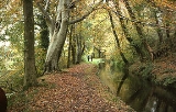
Tavistock Canal
Encyclopedia
The Tavistock Canal is a canal
in the county of Devon
in England
. It was constructed early in the 19th century to link the town of Tavistock to Morwellham Quay
on the River Tamar
, where cargo could be loaded into ships. The canal is still in use to supply water to a hydro-electric power plant
at Morwellham Quay, and forms part of the Cornwall and West Devon Mining Landscape
World Heritage Site
. It is unusual for a canal, as it has a gentle slope over its length, resulting in a considerable flow of water.
, and although it is about 23 miles (37 km) from the sea, the river is still tidal there. The quay was the furthest point inland to which the river was navigable, and it had served Tavistock as a port since the twelfth century. Ships of 200 tons were using the quay by 1800, and there was a growing trade in copper, which was being mined locally, particularly since the Wheal Friendship mine had opened around 1797. In 1802, John Taylor
, a local civil engineer with interests in the mining of metal ores, surveyed the route for a canal to run from Tavistock to Morwellham, and it was discussed at a meeting held in March 1803 in Tavistock. The canal would be 16 feet (4.9 m) wide and 3 foot (0.9144 m) deep, and the Millhill slate quarries would be served by a branch from the main line. It would carry copper ore, both the Wheal Friendship and the Wheal Crowndale mine which had recently opened nearer to Tavistock. Other cargo would include slate, limestone and general goods. The canal would be suitable for tub-boats, and would be built entirely on land owned by the Duke of Bedford, who approved of the project. The estimated cost was £40,000, which included provision for testing any mineral lodes which were found during its construction, and the rights to those minerals, together with dues payable to the Duke for their extraction, were negotiated before the project began.
An Act of Parliament
was obtained in 1803 which gave the proprietors the power to raise £50,000 in £50 shares for the construction of the canal. The land was donated by the Duke, who took 125 of the 1000 shares. Taylor, who also managed Wheal Friendship mine, acted as engineer, and work started in August 1803. The largest engineering feature of the canal was a tunnel under Morwell Down. When cutting of it began, copper ore was discovered close to the Tavistock end, and this became the Wheal Crebor mine, which was managed as a separate project. It had its own entrance, by the tunnel entrance, and used water-powered machinery, driven by water flowing along the canal. The canal from Tavistock to the tunnel mouth, including an aqueduct which carried it over the River Lumburn
, was opened in 1805. The 2540 yards (2.3 km) tunnel was cut through rock, was of small bore, and required Taylor to construct two types of pump, one to keep the workings drained, and the other to clean the air. Both were powered by water wheel
s, driven by the canal water. The tunnel, which was driven through elvan
rock and killas clay-slate, is 360 feet (109.7 m) below Morwell Down at its deepest point, and it was finished in 1816.
At the tunnel's southern end, the canal was on the 250 feet (76.2 m) contour, and Taylor constructed an inclined plane
to drop the level by 237 feet (72.2 m) to the quay at Morwellham. There were two tracks, one running to the quay, and a second which ended some 30 feet (9.1 m) higher at ore-chutes above the Lower Copper Quay. The rails were initially "L" shaped cast iron plate rails, spaced 46 inches (1,168.4 mm) apart between the flanges, although trough-shaped rails were used in places on the quay, particularly where roads crossed the tracks. Four-wheeled tipping wagons which had larger wheels at the front than at the rear were used on the twin tracks, which operated independently. The system was powered by a large overshot waterwheel, 28 feet (8.5 m) in diameter and 4 feet (1.2 m) wide, situated alongside the winding house at the head of the incline, which was fed with water from the canal. It drove a declutchable winch, to which the wagons were attached by chains. Wagons arriving at the top of the incline passed onto a sloping platform, which moved to a horizontal position due to the weight of the wagon, and this disconnected the waterwheel from the drum holding the chain. The rails were later replaced by wrought iron edge rails, and the chains by cables.
firing a 21-gun salute. A "persistent legend" states that much of the construction work had been done by French prisoners of war, but the canal committee's annual account of construction progress makes no reference to this. The canal is unusual in that it was built with a gentle slope of about 1 ft per mile (20 cm per km). This was designed to attract industry to its banks, as it resulted in a flow of water along the canal, which aided the passage of boats towards the quay, and also enabled the powering of waterwheels along the route. Between 1817 and 1819, a 2 miles (3.2 km) extension was constructed to slate quarries
and a general wharf at Mill Hill. This cost £8,000, and because there was a lack of water to supply locks, the difference in level was accommodated by building a counter-balanced, double track inclined plane. Boats were loaded onto cradles, and the loaded boats passing down the incline raised the unladen ones, with three horses assisting if necessary. The incline was relatively shallow, as it was 936 feet (285.3 m) long and only rose by 19.5 feet (5.9 m) over this length. The rails were of "L" section, made of cast iron, and spaced 70.5 inches (1.8 m) between the flanges. The cradle was about 20 feet (6.1 m) long and ran on 24 inch (0.6096 m) cast iron wheels. The branch appears to have closed around 1831, but in 1844, the owners of a new slate quarry at Mill Hill requested that the company re-open the canal or replace it with a tramway. The canal above the Gunnislake to Tavistock road crossing was relaid as a tramway at a cost of £1,381, but the quarry was not a success, and only shipped slates between 1848 and 1850.
Despite its modest length, the canal's design and execution was a remarkable achievement, owing much to the foresight and determination of John Taylor. Driving a tunnel of such length through solid and often hard rock required new drainage techniques, and finishing it off with "the greatest inclined plane in Southern England" required great boldness. It carried slate, silver-lead ore and copper ore from the Tavistock area to the quay, and general goods including limestone, coal, iron and timber for Tavistock in the reverse direction. For nearly 40 years it was a profitable concern, carrying over one million tons of cargo during this period.
, but the canal was unable to profit from the discovery, as the ore, which was mined by the Devon Great Consols company lay in a different direction to the canal. However, in 1857-58 the mining company built a tramway from the mine to the quay. It arrived above the quay on the 400 feet (121.9 m) contour, and a second inclined plane was constructed, which ran through a tunnel beneath the village green.
In 1859, the railways arrived at Tavistock, in the form of the South Devon and Tavistock Railway
. In order to remain competitive, £300 was spent on renewing the equipment on the inclined plane, and thought was given to buying a tug. However, Mr T. Knight proposed a system of ropes powered by waterwheels to pull the boats through the tunnel, and the machinery was installed. After less than a year it was acknowledged that the system was a failure, but the committee failed to find a way to dispose of the rope, although they tried for many years. Traffic and profits continued to fall, despite reductions in the tolls. The company petitioned the Duke in 1866 to reduce tolls for the use of Morwellham Quay, but he did not respond. In 1870, they offered all of the shares to the Duke, at a price of £10 each, but again the Duke did not show interest. Two years later, the Duke made an offer of £8 per share, providing that the company paid half of the cost of an Act of Parliament to authorise transfer of ownership to him. This was accepted, and the Tavistock Canal Act was obtained in May 1873, after which the Duke paid £3,200 to the shareholders. Although he had no responsibility to keep the canal open, it was listed as being open in official returns for 1883, but not in 1898.
rudder
found in the tunnel in 1976 is on display at Morwellham Quay
Museum and recent archaeological survey work has found more wrought iron plates within the canal tunnel. A report from 1888 describes the boats as being 30 feet (9.1 m) in length, 5 feet (1.5 m) in width, and made of rivet
ted iron, while an earlier description from 1826 gives the width as 4 in 6 in (1.37 m) wide by 2 in 6 in (0.762 m) deep.
These iron barges were first referred to in 1811, when one was launched on the canal on Easter Monday. In all, nine were built between then and 1817, when 300 invited guests were carried along the canal in them on the occasion of the grand opening. They are of considerable international importance as they appear to be the earliest boats of any sort to have been built of wrought iron
, the second earliest having been launched on the Forth & Clyde Canal in 1816. The earliest iron boat of all, built in 1787 and launched on the River Severn
by John Wilkinson
of Broseley
Ironworks, Shropshire, is now thought to have been of cast iron
plates, bolted together.
. Passing through wharfs in Tavistock, it proceeds towards Morwellham Quay
in a fairly straight line, with a large horseshoe loop when it meets the valley of the River Lumburn
, which it crosses by a large aqueduct. The two mile Mill Hill branch turned off immediately after the aqueduct. After about 3 miles (4.8 km) the main line reaches the northern portal of the Morwell Down tunnel, which emerges 1.5 miles (2.4 km) later above the quay. A short length of canal after the tunnel brought boats to the top of the inclined plane.
. The last of these was to operate a tin
and wolfram
mill at the Bedford United Mine, a supply which ceased in 1930. In 1933 the canal was purchased by the West Devon Electric Supply Co. Ltd, who constructed a hydro-electric power plant at Morwellham Quay using the canal and tunnel as a water supply. The power plant and canal now belong to South West Water
, and still feed power to the National Grid.
A programme of archaeological survey of the canal commenced in 2004 and was still underway. Excavations in 2006–2007 uncovered the tunnel on the second inclined plane, part of which is now being restored.
Morwellham Quay is now an open-air museum. The Mill Hill Branch of the canal still survives (at least partially) though it is dry for its entire length; it can be clearly seen where it leaves the main canal just downstream of the Lumburn Aqueduct.
Canal
Canals are man-made channels for water. There are two types of canal:#Waterways: navigable transportation canals used for carrying ships and boats shipping goods and conveying people, further subdivided into two kinds:...
in the county of Devon
Devon
Devon is a large county in southwestern England. The county is sometimes referred to as Devonshire, although the term is rarely used inside the county itself as the county has never been officially "shired", it often indicates a traditional or historical context.The county shares borders with...
in England
England
England is a country that is part of the United Kingdom. It shares land borders with Scotland to the north and Wales to the west; the Irish Sea is to the north west, the Celtic Sea to the south west, with the North Sea to the east and the English Channel to the south separating it from continental...
. It was constructed early in the 19th century to link the town of Tavistock to Morwellham Quay
Morwellham Quay
Morwellham Quay is a historic river port in Devon, England that developed to support the local mines. The port had its peak in the Victorian era and is now run as a tourist attraction and museum...
on the River Tamar
River Tamar
The Tamar is a river in South West England, that forms most of the border between Devon and Cornwall . It is one of several British rivers whose ancient name is assumed to be derived from a prehistoric river word apparently meaning "dark flowing" and which it shares with the River Thames.The...
, where cargo could be loaded into ships. The canal is still in use to supply water to a hydro-electric power plant
Hydroelectricity
Hydroelectricity is the term referring to electricity generated by hydropower; the production of electrical power through the use of the gravitational force of falling or flowing water. It is the most widely used form of renewable energy...
at Morwellham Quay, and forms part of the Cornwall and West Devon Mining Landscape
Cornwall and West Devon Mining Landscape
The Cornwall and West Devon Mining Landscape is a World Heritage Site which includes select mining landscapes across Cornwall and West Devon in the south west of the United Kingdom...
World Heritage Site
World Heritage Site
A UNESCO World Heritage Site is a place that is listed by the UNESCO as of special cultural or physical significance...
. It is unusual for a canal, as it has a gentle slope over its length, resulting in a considerable flow of water.
History
Morwellham Quay is on the River TamarRiver Tamar
The Tamar is a river in South West England, that forms most of the border between Devon and Cornwall . It is one of several British rivers whose ancient name is assumed to be derived from a prehistoric river word apparently meaning "dark flowing" and which it shares with the River Thames.The...
, and although it is about 23 miles (37 km) from the sea, the river is still tidal there. The quay was the furthest point inland to which the river was navigable, and it had served Tavistock as a port since the twelfth century. Ships of 200 tons were using the quay by 1800, and there was a growing trade in copper, which was being mined locally, particularly since the Wheal Friendship mine had opened around 1797. In 1802, John Taylor
John Taylor (Civil Engineer)
John Taylor was an English land surveyor and civil engineer. He was born in Norwich, England and showed an interest in mining at a young age; in 1796 he improvised a mechanised copper ore crusher at Wheal Friendship, a mine just outside of Tavistock, Devon. This machine was improved over time and...
, a local civil engineer with interests in the mining of metal ores, surveyed the route for a canal to run from Tavistock to Morwellham, and it was discussed at a meeting held in March 1803 in Tavistock. The canal would be 16 feet (4.9 m) wide and 3 foot (0.9144 m) deep, and the Millhill slate quarries would be served by a branch from the main line. It would carry copper ore, both the Wheal Friendship and the Wheal Crowndale mine which had recently opened nearer to Tavistock. Other cargo would include slate, limestone and general goods. The canal would be suitable for tub-boats, and would be built entirely on land owned by the Duke of Bedford, who approved of the project. The estimated cost was £40,000, which included provision for testing any mineral lodes which were found during its construction, and the rights to those minerals, together with dues payable to the Duke for their extraction, were negotiated before the project began.
An Act of Parliament
Act of Parliament
An Act of Parliament is a statute enacted as primary legislation by a national or sub-national parliament. In the Republic of Ireland the term Act of the Oireachtas is used, and in the United States the term Act of Congress is used.In Commonwealth countries, the term is used both in a narrow...
was obtained in 1803 which gave the proprietors the power to raise £50,000 in £50 shares for the construction of the canal. The land was donated by the Duke, who took 125 of the 1000 shares. Taylor, who also managed Wheal Friendship mine, acted as engineer, and work started in August 1803. The largest engineering feature of the canal was a tunnel under Morwell Down. When cutting of it began, copper ore was discovered close to the Tavistock end, and this became the Wheal Crebor mine, which was managed as a separate project. It had its own entrance, by the tunnel entrance, and used water-powered machinery, driven by water flowing along the canal. The canal from Tavistock to the tunnel mouth, including an aqueduct which carried it over the River Lumburn
River Lumburn
The Lumburn is a river on Dartmoor, Devon, England.It is a tributary of the River Tavy.-See also:*Rivers of the United Kingdom...
, was opened in 1805. The 2540 yards (2.3 km) tunnel was cut through rock, was of small bore, and required Taylor to construct two types of pump, one to keep the workings drained, and the other to clean the air. Both were powered by water wheel
Water wheel
A water wheel is a machine for converting the energy of free-flowing or falling water into useful forms of power. A water wheel consists of a large wooden or metal wheel, with a number of blades or buckets arranged on the outside rim forming the driving surface...
s, driven by the canal water. The tunnel, which was driven through elvan
Elvan
Elvan is a name used in Cornwall and Devon for the native varieties of quartz-porphyry. They are dispersed irregularly in the Upper Devonian series of rocks and some of them make very fine building stones...
rock and killas clay-slate, is 360 feet (109.7 m) below Morwell Down at its deepest point, and it was finished in 1816.
At the tunnel's southern end, the canal was on the 250 feet (76.2 m) contour, and Taylor constructed an inclined plane
Canal inclined plane
An inclined plane is a system used on some canals for raising boats between different water levels. Boats may be conveyed afloat, in caissons, or may be carried in cradles or slings. It can be considered as a specialised type of cable railway....
to drop the level by 237 feet (72.2 m) to the quay at Morwellham. There were two tracks, one running to the quay, and a second which ended some 30 feet (9.1 m) higher at ore-chutes above the Lower Copper Quay. The rails were initially "L" shaped cast iron plate rails, spaced 46 inches (1,168.4 mm) apart between the flanges, although trough-shaped rails were used in places on the quay, particularly where roads crossed the tracks. Four-wheeled tipping wagons which had larger wheels at the front than at the rear were used on the twin tracks, which operated independently. The system was powered by a large overshot waterwheel, 28 feet (8.5 m) in diameter and 4 feet (1.2 m) wide, situated alongside the winding house at the head of the incline, which was fed with water from the canal. It drove a declutchable winch, to which the wagons were attached by chains. Wagons arriving at the top of the incline passed onto a sloping platform, which moved to a horizontal position due to the weight of the wagon, and this disconnected the waterwheel from the drum holding the chain. The rails were later replaced by wrought iron edge rails, and the chains by cables.
Opening
The main line of the canal was formally opened on 24 June 1817, which was marked by ships on the River TamarRiver Tamar
The Tamar is a river in South West England, that forms most of the border between Devon and Cornwall . It is one of several British rivers whose ancient name is assumed to be derived from a prehistoric river word apparently meaning "dark flowing" and which it shares with the River Thames.The...
firing a 21-gun salute. A "persistent legend" states that much of the construction work had been done by French prisoners of war, but the canal committee's annual account of construction progress makes no reference to this. The canal is unusual in that it was built with a gentle slope of about 1 ft per mile (20 cm per km). This was designed to attract industry to its banks, as it resulted in a flow of water along the canal, which aided the passage of boats towards the quay, and also enabled the powering of waterwheels along the route. Between 1817 and 1819, a 2 miles (3.2 km) extension was constructed to slate quarries
Slate industry
The slate industry is the industry related to the extraction and processing of slate. Slate is either quarried from a slate quarry or reached by tunneling in a slate mine. Common uses for slate include as a roofing material, a flooring material, gravestones and memorial tablets, and for electrical...
and a general wharf at Mill Hill. This cost £8,000, and because there was a lack of water to supply locks, the difference in level was accommodated by building a counter-balanced, double track inclined plane. Boats were loaded onto cradles, and the loaded boats passing down the incline raised the unladen ones, with three horses assisting if necessary. The incline was relatively shallow, as it was 936 feet (285.3 m) long and only rose by 19.5 feet (5.9 m) over this length. The rails were of "L" section, made of cast iron, and spaced 70.5 inches (1.8 m) between the flanges. The cradle was about 20 feet (6.1 m) long and ran on 24 inch (0.6096 m) cast iron wheels. The branch appears to have closed around 1831, but in 1844, the owners of a new slate quarry at Mill Hill requested that the company re-open the canal or replace it with a tramway. The canal above the Gunnislake to Tavistock road crossing was relaid as a tramway at a cost of £1,381, but the quarry was not a success, and only shipped slates between 1848 and 1850.
Despite its modest length, the canal's design and execution was a remarkable achievement, owing much to the foresight and determination of John Taylor. Driving a tunnel of such length through solid and often hard rock required new drainage techniques, and finishing it off with "the greatest inclined plane in Southern England" required great boldness. It carried slate, silver-lead ore and copper ore from the Tavistock area to the quay, and general goods including limestone, coal, iron and timber for Tavistock in the reverse direction. For nearly 40 years it was a profitable concern, carrying over one million tons of cargo during this period.
Decline
In 1844, the largest lode of copper ore in Europe was discovered just 4 miles (6.4 km) from Morwellham QuayMorwellham Quay
Morwellham Quay is a historic river port in Devon, England that developed to support the local mines. The port had its peak in the Victorian era and is now run as a tourist attraction and museum...
, but the canal was unable to profit from the discovery, as the ore, which was mined by the Devon Great Consols company lay in a different direction to the canal. However, in 1857-58 the mining company built a tramway from the mine to the quay. It arrived above the quay on the 400 feet (121.9 m) contour, and a second inclined plane was constructed, which ran through a tunnel beneath the village green.
In 1859, the railways arrived at Tavistock, in the form of the South Devon and Tavistock Railway
South Devon and Tavistock Railway
The South Devon and Tavistock Railway was a broad gauge railway linking Plymouth with Tavistock in Devon, England. It opened in 1859, was extended by the Launceston and South Devon Railway to Launceston, Cornwall, in 1865, and was closed in 1962....
. In order to remain competitive, £300 was spent on renewing the equipment on the inclined plane, and thought was given to buying a tug. However, Mr T. Knight proposed a system of ropes powered by waterwheels to pull the boats through the tunnel, and the machinery was installed. After less than a year it was acknowledged that the system was a failure, but the committee failed to find a way to dispose of the rope, although they tried for many years. Traffic and profits continued to fall, despite reductions in the tolls. The company petitioned the Duke in 1866 to reduce tolls for the use of Morwellham Quay, but he did not respond. In 1870, they offered all of the shares to the Duke, at a price of £10 each, but again the Duke did not show interest. Two years later, the Duke made an offer of £8 per share, providing that the company paid half of the cost of an Act of Parliament to authorise transfer of ownership to him. This was accepted, and the Tavistock Canal Act was obtained in May 1873, after which the Duke paid £3,200 to the shareholders. Although he had no responsibility to keep the canal open, it was listed as being open in official returns for 1883, but not in 1898.
Boats
None of the boats used on the canal has survived completely, but a wrought ironWrought iron
thumb|The [[Eiffel tower]] is constructed from [[puddle iron]], a form of wrought ironWrought iron is an iron alloy with a very low carbon...
rudder
Rudder
A rudder is a device used to steer a ship, boat, submarine, hovercraft, aircraft or other conveyance that moves through a medium . On an aircraft the rudder is used primarily to counter adverse yaw and p-factor and is not the primary control used to turn the airplane...
found in the tunnel in 1976 is on display at Morwellham Quay
Morwellham Quay
Morwellham Quay is a historic river port in Devon, England that developed to support the local mines. The port had its peak in the Victorian era and is now run as a tourist attraction and museum...
Museum and recent archaeological survey work has found more wrought iron plates within the canal tunnel. A report from 1888 describes the boats as being 30 feet (9.1 m) in length, 5 feet (1.5 m) in width, and made of rivet
Rivet
A rivet is a permanent mechanical fastener. Before being installed a rivet consists of a smooth cylindrical shaft with a head on one end. The end opposite the head is called the buck-tail. On installation the rivet is placed in a punched or pre-drilled hole, and the tail is upset, or bucked A rivet...
ted iron, while an earlier description from 1826 gives the width as 4 in 6 in (1.37 m) wide by 2 in 6 in (0.762 m) deep.
These iron barges were first referred to in 1811, when one was launched on the canal on Easter Monday. In all, nine were built between then and 1817, when 300 invited guests were carried along the canal in them on the occasion of the grand opening. They are of considerable international importance as they appear to be the earliest boats of any sort to have been built of wrought iron
Wrought iron
thumb|The [[Eiffel tower]] is constructed from [[puddle iron]], a form of wrought ironWrought iron is an iron alloy with a very low carbon...
, the second earliest having been launched on the Forth & Clyde Canal in 1816. The earliest iron boat of all, built in 1787 and launched on the River Severn
River Severn
The River Severn is the longest river in Great Britain, at about , but the second longest on the British Isles, behind the River Shannon. It rises at an altitude of on Plynlimon, Ceredigion near Llanidloes, Powys, in the Cambrian Mountains of mid Wales...
by John Wilkinson
John Wilkinson (industrialist)
John "Iron-Mad" Wilkinson was an English industrialist who pioneered the use and manufacture of cast iron and cast-iron goods in the Industrial Revolution.-Early life:...
of Broseley
Broseley
Broseley is a small town in Shropshire, England with a population of 4,912 . The River Severn flows to the north and east of the town. Broseley has a town council and is part of the area controlled by Shropshire Council. The first iron bridge in the world was built in 1779 to link Broseley with...
Ironworks, Shropshire, is now thought to have been of cast iron
Cast iron
Cast iron is derived from pig iron, and while it usually refers to gray iron, it also identifies a large group of ferrous alloys which solidify with a eutectic. The color of a fractured surface can be used to identify an alloy. White cast iron is named after its white surface when fractured, due...
plates, bolted together.
The route
The main line of the canal starts at the Abbey Weir in Tavistock, where water is taken from the River TavyRiver Tavy
The Tavy is a river on Dartmoor, Devon, England. The name derives from the Brythonic root "Taff", the original meaning of which has now been lost...
. Passing through wharfs in Tavistock, it proceeds towards Morwellham Quay
Morwellham Quay
Morwellham Quay is a historic river port in Devon, England that developed to support the local mines. The port had its peak in the Victorian era and is now run as a tourist attraction and museum...
in a fairly straight line, with a large horseshoe loop when it meets the valley of the River Lumburn
River Lumburn
The Lumburn is a river on Dartmoor, Devon, England.It is a tributary of the River Tavy.-See also:*Rivers of the United Kingdom...
, which it crosses by a large aqueduct. The two mile Mill Hill branch turned off immediately after the aqueduct. After about 3 miles (4.8 km) the main line reaches the northern portal of the Morwell Down tunnel, which emerges 1.5 miles (2.4 km) later above the quay. A short length of canal after the tunnel brought boats to the top of the inclined plane.
Today
After the canal closed to navigation it continued to be used to supply water to various industrial activities at Morwellham QuayMorwellham Quay
Morwellham Quay is a historic river port in Devon, England that developed to support the local mines. The port had its peak in the Victorian era and is now run as a tourist attraction and museum...
. The last of these was to operate a tin
Cassiterite
Cassiterite is a tin oxide mineral, SnO2. It is generally opaque, but it is translucent in thin crystals. Its luster and multiple crystal faces produce a desirable gem...
and wolfram
Wolframite
Wolframite WO4, is an iron manganese tungstate mineral that is the intermediate between ferberite and huebernite . Along with scheelite, the wolframite series are the most important tungsten ore minerals. Wolframite is found in quartz veins and pegmatites associated with granitic intrusives...
mill at the Bedford United Mine, a supply which ceased in 1930. In 1933 the canal was purchased by the West Devon Electric Supply Co. Ltd, who constructed a hydro-electric power plant at Morwellham Quay using the canal and tunnel as a water supply. The power plant and canal now belong to South West Water
South West Water
South West Water provides drinking water and waste water services throughout Cornwall and Devon and in small areas of Dorset and Somerset. South West Water came into being in 1989 with the privatisation of the water industry...
, and still feed power to the National Grid.
A programme of archaeological survey of the canal commenced in 2004 and was still underway. Excavations in 2006–2007 uncovered the tunnel on the second inclined plane, part of which is now being restored.
Morwellham Quay is now an open-air museum. The Mill Hill Branch of the canal still survives (at least partially) though it is dry for its entire length; it can be clearly seen where it leaves the main canal just downstream of the Lumburn Aqueduct.
Points of interest
See also
- Canals of Great Britain
- History of the British canal systemHistory of the British canal systemThe British canal system of water transport played a vital role in the United Kingdom's Industrial Revolution at a time when roads were only just emerging from the medieval mud and long trains of pack horses were the only means of "mass" transit by road of raw materials and finished products The...