
River Tamar
Encyclopedia
The Tamar is a river
in South West England
, that forms most of the border between Devon
(to the east) and Cornwall
(to the west). It is one of several British rivers whose ancient name is assumed to be derived from a prehistoric river word apparently meaning "dark flowing" and which it shares with the River Thames.
The Tamar's source is less than 6 km (3.7 mi) from the north Cornish coast, but it flows southward. At its mouth, the Tamar flows into the Hamoaze
before entering Plymouth Sound
. Tributaries of the river include the rivers Inny, Ottery
, Kensey and Lynher
(or St Germans River) on the Cornish side, and the Deer and Tavy
on the Devon side.
covers around 195 km² (75.3 sq mi) around the lower Tamar (below Launceston) and its tributaries the Tavy
and the Lynher
. It was first proposed in 1963, but was not designated until 1995.
were mineralised by fluids driven by the heat of the earth's core, which gave rise to ores containing tin
, copper
, tungsten
, lead
and other minerals in the Valley. The medieval estate of Cotehele
, owned by the Edgcumbe
family, was a significant producer of silver
for the Royal Mint
. During the industrial revolution, there was significant mining activity near the river, between Gunnislake and Weir Quay. During this period, the Tamar was an important river for shipping copper from ports such as Morwellham Quay
, Calstock
and New Quay (Devon)
to south Wales where it would be smelted. The valley forms district A10i of the Cornwall and West Devon Mining Landscape
.
The river has long been famous for the quality of its salmon
whilst the valley was known nationally for the high quality, and early, soft fruit and market gardens sheltered by its steeply winding slopes.
as far inland as Weir Quay, near Bere Alston
, where the estuary
narrows into the tidal river. Vessels of 300 tons sailed as far inland as Morwellham
, 24 miles from the sea. A further 2-mile stretch to Weir Head, near Gunnislake
, the tidal limit
, was accessible to smaller passenger ships. In 1794 the Tamar Manure Navigation Company was formed to extend navigation inland for a further 30 miles, to North Tamerton
in the river headwaters, but the project advanced no further than Gunnislake. Barges of up to 30 tons could then proceed as far as Gunnislake New Bridge, bypassing the weir through the new canal. The import of fertiliser and coal and the export of bricks along this short section proved profitable for many years. The section from Launceston to Tamerton was completed in 1826 as part of a separate project, the Bude Canal
.
A typical Tamar vessel was a sailing barge
, built on the open river bank, of up to 60 tons, with a peaked, gaff-rigged mainsail
and a fore staysail
.
The initial importance of navigation on the river was to cross this natural obstacle between the counties of Devon and Cornwall, and the old ferry crossings were later to develop into the busy river quays of the eighteenth and nineteenth centuries. In mediaeval times the transport of goods to supply the Benedictine abbey at Tavistock
, four miles by track
from the river port of Morwellham, was significant. Sea sand from the coast was imported to spread on farmland, until in the eighteenth century a dressing of lime
was found to be more beneficial. Large quantities of limestone were then imported to burn in the numerous limekilns on the river quays; the lime had to be made locally as it was not slaked
before application and was too reactive for transport by water after burning. Later, street sweepings and other refuse from Plymouth
and Devonport
, together with bones for the newly discovered bone fertiliser
, were carried inland to manure the fields.
Tavistock was one of the three stannary towns
of Devon and large quantities of refined tin were exported through Morwellham from twelfth century until 1838, when the requirement to pay duty on the metal at one of the specified towns was relaxed. The opening of the Tavistock Canal
, between Tavistock and Morwellham, in 1817 facilitated traffic. Later, the East Cornwall Mineral Railway
provided an outlet through the quays of Calstock
from the Cornish side of the valley. Other significant cargoes exported were quarried granite and, later, copper, lead, manganese and tin ores, with their important by-product of arsenic
. Arsenic was extracted from mispickel
, once regarded as a waste product but later offering an important source of revenue as copper and tin extraction declined in profitability. The refined product was exported worldwide, in particular to the southern United States, where it was used as an insecticide in the cotton fields.
In the thirteenth century lead and silver output from the royal mines on the Bere peninsula
(between the Tamar and the Tavy
) was significant, and production continued intermittently until the nineteenth century. The Johnson Matthey
smelting works at Weir Quay extracted silver and lead not only from local ore, but from ore imported by sea from Europe and as far away as Newfoundland
.
The development of the "Three Towns
" (Plymouth, Devonport and Stonehouse
) at the mouth of the river offered an important market for the valley's agricultural produce, needed in particular to serve the victualling requirements of the royal dockyard
, and this was always carried by boat. In 1820 or 1821 the first paddle steamer on the Tamar inaugurated a service between Calstock and Devonport to deliver foodstuffs. In 1859 a rail connection from Plymouth to London was opened, and fresh produce could be landed at the Devonport steamer quays in the evening and be on sale in London by the next morning. The growing city population created a large demand for sightseeing cruises on the river and this was a significant source of traffic from 1823, with the launch of the Cornish steam packet Sir Francis Drake, until the outbreak of the second world war
.
Mineral traffic on the river diminished towards the latter end of the nineteenth century, after the Plymouth, Devonport and South Western Junction Railway
reached Tavistock in 1859 (so making the Tavistock Canal to Morwellham redundant for transport, although it remains in use as a source of hydropower
) and as the copper and tin mines became exhausted. The decline accelerated from 1894 when the East Cornwall Mineral Railway, until then linked to the outside world only through the port of Calstock, was extended to the Plymouth, Devonport and South Western Junction Railway at Bere Alston
. Tourist and market traffic on the river, using purpose-built or converted steamers, remained substantial until the Devonport piers were closed and the ships requisitioned on the outbreak of war in 1939. Pleasure craft still operate on the river from Devonport, but on a much reduced scale.
on the 'Cornish' side. The modern administrative border
between Devon and Cornwall more closely follows the Tamar than the historic county border
. Several villages north of Launceston, to the west of the Tamar, were transferred to Devon somewhen in the eleventh century; the border was changed to follow the River Ottery
westward, rather than the Tamar. Boundary changes of 1966 restored the border to the Tamar. Part of the Rame Peninsula was in Devon until 1844, when the parish of Maker
was transferred to Cornwall.
(1859), the first crossing of the lower Tamar, and the Tamar Bridge
, a toll bridge
on the A38
trunk road
. Both of these bridges are between Saltash
(known as the Gateway to Cornwall) and Plymouth.
filling. Though unusual landscape features are often named after the devil (e.g. devil's frying pan) it used to be said that the devil never came to Cornwall: he once reached Torpoint and immediately noticed that various kinds of pie were customary; he feared that devilly pie might be the next kind so returned to Devon.
River
A river is a natural watercourse, usually freshwater, flowing towards an ocean, a lake, a sea, or another river. In a few cases, a river simply flows into the ground or dries up completely before reaching another body of water. Small rivers may also be called by several other names, including...
in South West England
South West England
South West England is one of the regions of England defined by the Government of the United Kingdom for statistical and other purposes. It is the largest such region in area, covering and comprising Bristol, Gloucestershire, Somerset, Dorset, Wiltshire, Devon, Cornwall and the Isles of Scilly. ...
, that forms most of the border between Devon
Devon
Devon is a large county in southwestern England. The county is sometimes referred to as Devonshire, although the term is rarely used inside the county itself as the county has never been officially "shired", it often indicates a traditional or historical context.The county shares borders with...
(to the east) and Cornwall
Cornwall
Cornwall is a unitary authority and ceremonial county of England, within the United Kingdom. It is bordered to the north and west by the Celtic Sea, to the south by the English Channel, and to the east by the county of Devon, over the River Tamar. Cornwall has a population of , and covers an area of...
(to the west). It is one of several British rivers whose ancient name is assumed to be derived from a prehistoric river word apparently meaning "dark flowing" and which it shares with the River Thames.
The Tamar's source is less than 6 km (3.7 mi) from the north Cornish coast, but it flows southward. At its mouth, the Tamar flows into the Hamoaze
Hamoaze
The Hamoaze is an estuarine stretch of the tidal River Tamar, between the River Lynher and Plymouth Sound, England.The Hamoaze flows past Devonport Dockyard, which belongs to the Royal Navy...
before entering Plymouth Sound
Plymouth Sound
Plymouth Sound, or locally just The Sound, is a bay at Plymouth in England.Its southwest and southeast corners are Penlee Point in Cornwall and Wembury Point on Devon, a distance of about 3 nautical miles . Its northern limit is Plymouth Hoe giving a north-south distance of nearly 3 nautical miles...
. Tributaries of the river include the rivers Inny, Ottery
River Ottery
The River Ottery is a small river in northeast Cornwall, United Kingdom. The river is approximately twenty miles long from its source southeast of Otterham to its confluence with the River Tamar at Nether Bridge, two miles northeast of Launceston.The headwaters of the River Ottery are within the...
, Kensey and Lynher
River Lynher
The River Lynher flows through east Cornwall, UK, passing St Germans and enters the River Tamar at the Hamoaze, which in turn flows into Plymouth Sound.-Geography:...
(or St Germans River) on the Cornish side, and the Deer and Tavy
River Tavy
The Tavy is a river on Dartmoor, Devon, England. The name derives from the Brythonic root "Taff", the original meaning of which has now been lost...
on the Devon side.
Tamar Valley AONB
The Tamar Valley Area of Outstanding Natural BeautyArea of Outstanding Natural Beauty
An Area of Outstanding Natural Beauty is an area of countryside considered to have significant landscape value in England, Wales or Northern Ireland, that has been specially designated by the Countryside Agency on behalf of the United Kingdom government; the Countryside Council for Wales on...
covers around 195 km² (75.3 sq mi) around the lower Tamar (below Launceston) and its tributaries the Tavy
River Tavy
The Tavy is a river on Dartmoor, Devon, England. The name derives from the Brythonic root "Taff", the original meaning of which has now been lost...
and the Lynher
River Lynher
The River Lynher flows through east Cornwall, UK, passing St Germans and enters the River Tamar at the Hamoaze, which in turn flows into Plymouth Sound.-Geography:...
. It was first proposed in 1963, but was not designated until 1995.
Economy
Rocks around the edge of DartmoorDartmoor
Dartmoor is an area of moorland in south Devon, England. Protected by National Park status, it covers .The granite upland dates from the Carboniferous period of geological history. The moorland is capped with many exposed granite hilltops known as tors, providing habitats for Dartmoor wildlife. The...
were mineralised by fluids driven by the heat of the earth's core, which gave rise to ores containing tin
Tin
Tin is a chemical element with the symbol Sn and atomic number 50. It is a main group metal in group 14 of the periodic table. Tin shows chemical similarity to both neighboring group 14 elements, germanium and lead and has two possible oxidation states, +2 and the slightly more stable +4...
, copper
Copper
Copper is a chemical element with the symbol Cu and atomic number 29. It is a ductile metal with very high thermal and electrical conductivity. Pure copper is soft and malleable; an exposed surface has a reddish-orange tarnish...
, tungsten
Tungsten
Tungsten , also known as wolfram , is a chemical element with the chemical symbol W and atomic number 74.A hard, rare metal under standard conditions when uncombined, tungsten is found naturally on Earth only in chemical compounds. It was identified as a new element in 1781, and first isolated as...
, lead
Lead
Lead is a main-group element in the carbon group with the symbol Pb and atomic number 82. Lead is a soft, malleable poor metal. It is also counted as one of the heavy metals. Metallic lead has a bluish-white color after being freshly cut, but it soon tarnishes to a dull grayish color when exposed...
and other minerals in the Valley. The medieval estate of Cotehele
Cotehele
Cotehele, , is a mediaeval/Tudor house located in the parish of Calstock, Cornwall, England, UK. In Cornish the placename is Koesheyl . Probably originating circa 1300, the main phases of building appear to have been by Sir Richard Edgcumbe from 1485–89 and his son, Sir Piers Edgcumbe, from...
, owned by the Edgcumbe
Earl of Mount Edgcumbe
Earl of Mount Edgcumbe is a title in the Peerage of Great Britain. It was created in 1789 for George Edgcumbe, 3rd Baron Edgcumbe. The Edgcumbe family descends from Sir Piers Edgcumbe of Cotehele in Cornwall, who acquired the Mount Edgcumbe estate near Plymouth through marriage in the early 16th...
family, was a significant producer of silver
Silver
Silver is a metallic chemical element with the chemical symbol Ag and atomic number 47. A soft, white, lustrous transition metal, it has the highest electrical conductivity of any element and the highest thermal conductivity of any metal...
for the Royal Mint
Royal Mint
The Royal Mint is the body permitted to manufacture, or mint, coins in the United Kingdom. The Mint originated over 1,100 years ago, but since 2009 it operates as Royal Mint Ltd, a company which has an exclusive contract with HM Treasury to supply all coinage for the UK...
. During the industrial revolution, there was significant mining activity near the river, between Gunnislake and Weir Quay. During this period, the Tamar was an important river for shipping copper from ports such as Morwellham Quay
Morwellham Quay
Morwellham Quay is a historic river port in Devon, England that developed to support the local mines. The port had its peak in the Victorian era and is now run as a tourist attraction and museum...
, Calstock
Calstock
Calstock is civil parish and a large village in south east Cornwall, England, United Kingdom, on the border with Devon. The village is situated on the River Tamar south west of Tavistock and north of Plymouth....
and New Quay (Devon)
New Quay (Devon)
New Quay is a small abandoned village on the banks of the river Tamar in Devon, the village is just downstream of the similar port of Morwellham Quay . New Quay was formerly an important copper and arsenic port serving the local mines...
to south Wales where it would be smelted. The valley forms district A10i of the Cornwall and West Devon Mining Landscape
Cornwall and West Devon Mining Landscape
The Cornwall and West Devon Mining Landscape is a World Heritage Site which includes select mining landscapes across Cornwall and West Devon in the south west of the United Kingdom...
.
The river has long been famous for the quality of its salmon
Salmon
Salmon is the common name for several species of fish in the family Salmonidae. Several other fish in the same family are called trout; the difference is often said to be that salmon migrate and trout are resident, but this distinction does not strictly hold true...
whilst the valley was known nationally for the high quality, and early, soft fruit and market gardens sheltered by its steeply winding slopes.
Navigation
The Tamar is navigable by sea-going ships of up to 400 register tonsTonnage
Tonnage is a measure of the size or cargo carrying capacity of a ship. The term derives from the taxation paid on tuns or casks of wine, and was later used in reference to the weight of a ship's cargo; however, in modern maritime usage, "tonnage" specifically refers to a calculation of the volume...
as far inland as Weir Quay, near Bere Alston
Bere Alston
Bere Alston is a small village in West Devon in the county of Devon in England. It forms part of the civil parish of Bere Ferrers.-History and geography:...
, where the estuary
Tamar–Tavy Estuary
The Tamar–Tavy Estuary is a Site of Special Scientific Interest covering the tidal estuaries of the River Tamar and the River Tavy on the border between Cornwall and Devon in England, UK. Part of the Tamar estuary also forms the Tamar Estuary Nature Reserve, owned by the Cornwall Wildlife Trust...
narrows into the tidal river. Vessels of 300 tons sailed as far inland as Morwellham
Morwellham Quay
Morwellham Quay is a historic river port in Devon, England that developed to support the local mines. The port had its peak in the Victorian era and is now run as a tourist attraction and museum...
, 24 miles from the sea. A further 2-mile stretch to Weir Head, near Gunnislake
Gunnislake
Gunnislake is a large village in east Cornwall, United Kingdom. It is situated in the Tamar Valley approximately ten miles north of Plymouth...
, the tidal limit
Head of tide
Head of tide is the farthest point upstream where a river is affected by tidal fluctuations. This applies to rivers which flow into tidal bodies such as oceans, bays and sloughs. Though this point may vary due to storms and seasonal or annual differences in water flows, there is generally an...
, was accessible to smaller passenger ships. In 1794 the Tamar Manure Navigation Company was formed to extend navigation inland for a further 30 miles, to North Tamerton
North Tamerton
North Tamerton is a civil parish and village in east Cornwall, United Kingdom. The village is situated approximately eight miles southeast of Bude and eight miles north of Launceston....
in the river headwaters, but the project advanced no further than Gunnislake. Barges of up to 30 tons could then proceed as far as Gunnislake New Bridge, bypassing the weir through the new canal. The import of fertiliser and coal and the export of bricks along this short section proved profitable for many years. The section from Launceston to Tamerton was completed in 1826 as part of a separate project, the Bude Canal
Bude Canal
The Bude Canal was a canal built to serve the hilly hinterland in the Devon and Cornwall border territory in the United Kingdom, chiefly to bring lime-bearing sand for agricultural fertiliser. The Bude Canal system was one of the most unusual in Britain....
.
A typical Tamar vessel was a sailing barge
Barge
A barge is a flat-bottomed boat, built mainly for river and canal transport of heavy goods. Some barges are not self-propelled and need to be towed by tugboats or pushed by towboats...
, built on the open river bank, of up to 60 tons, with a peaked, gaff-rigged mainsail
Gaff rig
Gaff rig is a sailing rig in which the sail is four-cornered, fore-and-aft rigged, controlled at its peak and, usually, its entire head by a spar called the gaff...
and a fore staysail
Staysail
A staysail is a fore-and-aft rigged sail whose luff can be affixed to a stay running forward from a mast to the deck, the bowsprit or to another mast....
.
The initial importance of navigation on the river was to cross this natural obstacle between the counties of Devon and Cornwall, and the old ferry crossings were later to develop into the busy river quays of the eighteenth and nineteenth centuries. In mediaeval times the transport of goods to supply the Benedictine abbey at Tavistock
Tavistock Abbey
Tavistock Abbey, also known as the Abbey of Saint Mary and Saint Rumon, is a ruined Benedictine abbey in Tavistock, Devon. Nothing remains of the abbey except the refectory, two gateways and a porch. The abbey church, dedicated to Our Lady and St Rumon, was destroyed by Danish raiders in 997 and...
, four miles by track
Trail
A trail is a path with a rough beaten or dirt/stone surface used for travel. Trails may be for use only by walkers and in some places are the main access route to remote settlements...
from the river port of Morwellham, was significant. Sea sand from the coast was imported to spread on farmland, until in the eighteenth century a dressing of lime
Calcium oxide
Calcium oxide , commonly known as quicklime or burnt lime, is a widely used chemical compound. It is a white, caustic, alkaline crystalline solid at room temperature....
was found to be more beneficial. Large quantities of limestone were then imported to burn in the numerous limekilns on the river quays; the lime had to be made locally as it was not slaked
Slaking (geology)
Slaking is the process in which earth materials disintegrate and crumble when exposed to moisture. The term can be applied to natural geologic formations, land modified by or for human use, or to the use of earth materials in manufacturing or industry....
before application and was too reactive for transport by water after burning. Later, street sweepings and other refuse from Plymouth
Plymouth
Plymouth is a city and unitary authority area on the coast of Devon, England, about south-west of London. It is built between the mouths of the rivers Plym to the east and Tamar to the west, where they join Plymouth Sound...
and Devonport
Devonport, Devon
Devonport, formerly named Plymouth Dock or just Dock, is a district of Plymouth in the English county of Devon, although it was, at one time, the more important settlement. It became a county borough in 1889...
, together with bones for the newly discovered bone fertiliser
Bone meal
Bone meal is a mixture of crushed and coarsely ground bones that is used as an organic fertilizer for plants and formerly in animal feed. As a slow-release fertilizer, bone meal is primarily used as a source of phosphorus....
, were carried inland to manure the fields.
Tavistock was one of the three stannary towns
Stannary
The word stannary is historically applied to:*A tin mine, especially in Cornwall or Devon, South West England*A region containing tin works *A chartered entity comprising such a region, its works, and its workers...
of Devon and large quantities of refined tin were exported through Morwellham from twelfth century until 1838, when the requirement to pay duty on the metal at one of the specified towns was relaxed. The opening of the Tavistock Canal
Tavistock Canal
The Tavistock Canal is a canal in the county of Devon in England. It was constructed early in the 19th century to link the town of Tavistock to Morwellham Quay on the River Tamar, where cargo could be loaded into ships...
, between Tavistock and Morwellham, in 1817 facilitated traffic. Later, the East Cornwall Mineral Railway
East Cornwall Mineral Railway
The East Cornwall Mineral Railway was a narrow gauge industrial railway opened in 1872 to serve the iron ore and stone quarries around Callington in Cornwall....
provided an outlet through the quays of Calstock
Calstock
Calstock is civil parish and a large village in south east Cornwall, England, United Kingdom, on the border with Devon. The village is situated on the River Tamar south west of Tavistock and north of Plymouth....
from the Cornish side of the valley. Other significant cargoes exported were quarried granite and, later, copper, lead, manganese and tin ores, with their important by-product of arsenic
Arsenic
Arsenic is a chemical element with the symbol As, atomic number 33 and relative atomic mass 74.92. Arsenic occurs in many minerals, usually in conjunction with sulfur and metals, and also as a pure elemental crystal. It was first documented by Albertus Magnus in 1250.Arsenic is a metalloid...
. Arsenic was extracted from mispickel
Arsenopyrite
Arsenopyrite is an iron arsenic sulfide . It is a hard metallic, opaque, steel grey to silver white mineral with a relatively high specific gravity of 6.1. When dissolved in nitric acid, it releases elemental sulfur. When arsenopyrite is heated, it becomes magnetic and gives off toxic fumes...
, once regarded as a waste product but later offering an important source of revenue as copper and tin extraction declined in profitability. The refined product was exported worldwide, in particular to the southern United States, where it was used as an insecticide in the cotton fields.
In the thirteenth century lead and silver output from the royal mines on the Bere peninsula
Bere Ferrers
Bere Ferrers, sometimes called Beerferris, is a village and civil parish on the Bere peninsula in West Devon in the English county of Devon. It has a population of 3,066, and is located to the north of Plymouth, on the west bank of the River Tavy...
(between the Tamar and the Tavy
River Tavy
The Tavy is a river on Dartmoor, Devon, England. The name derives from the Brythonic root "Taff", the original meaning of which has now been lost...
) was significant, and production continued intermittently until the nineteenth century. The Johnson Matthey
Percival Norton Johnson
Percival Norton Johnson was the founder of Johnson Matthey, the United Kingdom's largest precious metals business.-Career:Having trained in his father's business as an assayer, Percival Johnson established his own firm in 1817...
smelting works at Weir Quay extracted silver and lead not only from local ore, but from ore imported by sea from Europe and as far away as Newfoundland
Newfoundland and Labrador
Newfoundland and Labrador is the easternmost province of Canada. Situated in the country's Atlantic region, it incorporates the island of Newfoundland and mainland Labrador with a combined area of . As of April 2011, the province's estimated population is 508,400...
.
The development of the "Three Towns
Three Towns
The Three Towns is a term used to refer to the neighbouring towns of Plymouth, Devonport and East Stonehouse in the county of Devon, England. They were formally merged in 1914 to become the Borough of Plymouth. In 1928, the Borough was granted City status by Royal Charter.-Notes:...
" (Plymouth, Devonport and Stonehouse
Stonehouse, Plymouth
East Stonehouse is one of three towns that were amalgamated into modern-day Plymouth. West Stonehouse was a village that is within the current Mount Edgcumbe Country Park in Cornwall...
) at the mouth of the river offered an important market for the valley's agricultural produce, needed in particular to serve the victualling requirements of the royal dockyard
HMNB Devonport
Her Majesty's Naval Base Devonport , is one of three operating bases in the United Kingdom for the Royal Navy . HMNB Devonport is located in Devonport, in the west of the city of Plymouth in Devon, England...
, and this was always carried by boat. In 1820 or 1821 the first paddle steamer on the Tamar inaugurated a service between Calstock and Devonport to deliver foodstuffs. In 1859 a rail connection from Plymouth to London was opened, and fresh produce could be landed at the Devonport steamer quays in the evening and be on sale in London by the next morning. The growing city population created a large demand for sightseeing cruises on the river and this was a significant source of traffic from 1823, with the launch of the Cornish steam packet Sir Francis Drake, until the outbreak of the second world war
World War II
World War II, or the Second World War , was a global conflict lasting from 1939 to 1945, involving most of the world's nations—including all of the great powers—eventually forming two opposing military alliances: the Allies and the Axis...
.
Mineral traffic on the river diminished towards the latter end of the nineteenth century, after the Plymouth, Devonport and South Western Junction Railway
Plymouth, Devonport and South Western Junction Railway
The Plymouth, Devonport and South Western Junction Railway in England was built by an independent company but operated by the London and South Western Railway as part of its main line to give it independent access to Plymouth. It ran from to Devonport Junction, just west of Plymouth North Road...
reached Tavistock in 1859 (so making the Tavistock Canal to Morwellham redundant for transport, although it remains in use as a source of hydropower
Hydropower
Hydropower, hydraulic power, hydrokinetic power or water power is power that is derived from the force or energy of falling water, which may be harnessed for useful purposes. Since ancient times, hydropower has been used for irrigation and the operation of various mechanical devices, such as...
) and as the copper and tin mines became exhausted. The decline accelerated from 1894 when the East Cornwall Mineral Railway, until then linked to the outside world only through the port of Calstock, was extended to the Plymouth, Devonport and South Western Junction Railway at Bere Alston
Bere Alston
Bere Alston is a small village in West Devon in the county of Devon in England. It forms part of the civil parish of Bere Ferrers.-History and geography:...
. Tourist and market traffic on the river, using purpose-built or converted steamers, remained substantial until the Devonport piers were closed and the ships requisitioned on the outbreak of war in 1939. Pleasure craft still operate on the river from Devonport, but on a much reduced scale.
Border
The east bank of the Tamar was fixed as the border of Cornwall by King Athelstan in the year 936. In a few places the border deviates from the river, leaving, for instance, the Devon village of BridgeruleBridgerule
Bridgerule is a village and civil parish in Devon, England, a mile from the border with Cornwall. The parish is divided by the River Tamar, which no longer forms the border between Devon and Cornwall there. The river frequently floods the High Street....
on the 'Cornish' side. The modern administrative border
Metropolitan and non-metropolitan counties of England
Metropolitan and non-metropolitan counties are one of the four levels of subdivisions of England used for the purposes of local government outside Greater London. As originally constituted, the metropolitan and non-metropolitan counties each consisted of multiple districts, had a county council and...
between Devon and Cornwall more closely follows the Tamar than the historic county border
Historic counties of England
The historic counties of England are subdivisions of England established for administration by the Normans and in most cases based on earlier Anglo-Saxon kingdoms and shires...
. Several villages north of Launceston, to the west of the Tamar, were transferred to Devon somewhen in the eleventh century; the border was changed to follow the River Ottery
River Ottery
The River Ottery is a small river in northeast Cornwall, United Kingdom. The river is approximately twenty miles long from its source southeast of Otterham to its confluence with the River Tamar at Nether Bridge, two miles northeast of Launceston.The headwaters of the River Ottery are within the...
westward, rather than the Tamar. Boundary changes of 1966 restored the border to the Tamar. Part of the Rame Peninsula was in Devon until 1844, when the parish of Maker
Maker
Maker is a village between Cawsand and Rame Head, situated on the Rame Peninsula, in Cornwall, United Kingdom.The name means a ruin in Cornish, but another Celtic name is Egloshayle, which means, the church on the estuary, a very apt description of the church's location.The village and its...
was transferred to Cornwall.
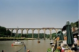
Crossings
The river has some 20 road crossings, including some medieval stone bridges, such as the crossing at Greystone Bridge near Lawhitton: this arched stone bridge was built in 1439. The lower Tamar is spanned by the Royal Albert BridgeRoyal Albert Bridge
The Royal Albert Bridge is a railway bridge that spans the River Tamar in the United Kingdom between Plymouth, on the Devon bank, and Saltash on the Cornish bank. Its unique design consists of two lenticular iron trusses above the water, with conventional plate-girder approach spans. This gives...
(1859), the first crossing of the lower Tamar, and the Tamar Bridge
Tamar Bridge
The Tamar Bridge is a major road bridge at Saltash in southwest England carrying traffic between Cornwall and Devon. When it opened in 1961 it was the longest suspension bridge in the United Kingdom...
, a toll bridge
Toll road
A toll road is a privately or publicly built road for which a driver pays a toll for use. Structures for which tolls are charged include toll bridges and toll tunnels. Non-toll roads are financed using other sources of revenue, most typically fuel tax or general tax funds...
on the A38
A38 road
The A38, part of which is also known as the Devon Expressway, is a major A-class trunk road in England.The road runs from Bodmin in Cornwall to Mansfield in Nottinghamshire. It is long, making it one of the longest A-roads in England. It was formerly known as the Leeds — Exeter Trunk Road,...
trunk road
Trunk road
A trunk road, trunk highway, or strategic road is a major road—usually connecting two or more cities, ports, airports, and other things.—which is the recommended route for long-distance and freight traffic...
. Both of these bridges are between Saltash
Saltash
Saltash is a town and civil parish in Cornwall, England, United Kingdom. It has a population of 14,964. It lies in the south east of Cornwall, facing Plymouth over the River Tamar. It was in the Caradon district until March 2009 and is known as "the gateway to Cornwall". Saltash means ash tree by...
(known as the Gateway to Cornwall) and Plymouth.
Folklore
A traditional Cornish tale claims that the devil would never dare to cross the River Tamar into Cornwall for fear of ending up as a pastyPasty
A pasty , sometimes known as a pastie or British pasty in the United States, is a filled pastry case, associated in particular with Cornwall in Great Britain. It is made by placing the uncooked filling on a flat pastry circle, and folding it to wrap the filling, crimping the edge at the side or top...
filling. Though unusual landscape features are often named after the devil (e.g. devil's frying pan) it used to be said that the devil never came to Cornwall: he once reached Torpoint and immediately noticed that various kinds of pie were customary; he feared that devilly pie might be the next kind so returned to Devon.
See also
- Tamar River (Tasmania)Tamar River (Tasmania)The Tamar River is a 70 kilometre estuarine in northern Tasmania formed by the merging of the North Esk River and South Esk Rivers at Launceston to its mouth at Low Head, north of the second largest settlement George Town and into the Bass Strait...
, named after this Tamar - Rivers of the United Kingdom
- Tamar Valley LineTamar Valley LineThe Tamar Valley Line is a railway line from Devonport in Plymouth Devon, to Gunnislake in Cornwall, United Kingdom. The line follows the River Tamar for much of its route.-History:...
- SaltashSaltashSaltash is a town and civil parish in Cornwall, England, United Kingdom. It has a population of 14,964. It lies in the south east of Cornwall, facing Plymouth over the River Tamar. It was in the Caradon district until March 2009 and is known as "the gateway to Cornwall". Saltash means ash tree by...
, "the gateway to Cornwall" - Royal Albert BridgeRoyal Albert BridgeThe Royal Albert Bridge is a railway bridge that spans the River Tamar in the United Kingdom between Plymouth, on the Devon bank, and Saltash on the Cornish bank. Its unique design consists of two lenticular iron trusses above the water, with conventional plate-girder approach spans. This gives...
between Plymouth, Devon and Saltash, Cornwall - Morwellham QuayMorwellham QuayMorwellham Quay is a historic river port in Devon, England that developed to support the local mines. The port had its peak in the Victorian era and is now run as a tourist attraction and museum...
, historic river port in Devon
Further reading
- Carrington, N. T. (1820) The Banks of Tamar, a poem, with other pieces. Plymouth Dock: Printed for the Author (another ed.: London: John Murray, 1828)