

Subdivisions of Zimbabwe
Encyclopedia
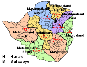
Zimbabwe has a centralised government and is divided into eight provinces
and two cities with provincial status, for administrative purposes. Each province has a provincial capital from where official business is usually carried out.
The names of most of the provinces were generated from the Mashonaland
and Matabeleland
divide at the time of colonisation: Mashonaland
was the territory occupied first by the British South Africa Company Pioneer Column and Matabeleland
the territory conquered during the First Matabele War
. This corresponds roughly to the precolonial territory of the Shona people
and the Matabele people, although there are significant ethnic minorities in most provinces. Each province is headed by a Provincial Governor, appointed by the President. The provincial government is run by a Provincial Administrator, appointed by the Public Service Commission. Other government functions at provincial level are carried out by provincial offices of national government departments.
The provinces are subdivided into 59 districts
and 1,200 wards
(sometimes referred to as municipalities). Each district is headed by a District Administrator, appointed by the Public Service Commission. There is also a Rural District Council, which appoints a Chief Executive Officer. The Rural District Council comprises elected ward councillors, the District Administrator and one representative of the chiefs (traditional leaders appointed under customary law) in the district. Other government functions at district level are carried out by district offices of national government departments.
At ward level there is a Ward Development Committee, comprising the elected ward councillor, the kraalheads (traditional leaders subordinate to chiefs) and representatives of Village Development Committees. Wards are subdivided into villages, each of which has an elected Village Development Committee and a Headman (traditional leader subordinate to the kraalhead).
Provinces of Zimbabwe
|Zimbabwe is divided into 8 provinces and 2 cities with provincial status:-See also:*Districts of Zimbabwe*Municipalities of Zimbabwe*List of provincial governors of Zimbabwe*ISO 3166-2:ZW-External links:*...
and two cities with provincial status, for administrative purposes. Each province has a provincial capital from where official business is usually carried out.
| Province | Capital |
|---|---|
| Bulawayo Bulawayo Bulawayo is the second largest city in Zimbabwe after the capital Harare, with an estimated population in 2010 of 2,000,000. It is located in Matabeleland, 439 km southwest of Harare, and is now treated as a separate provincial area from Matabeleland... |
Bulawayo |
| Harare Harare Harare before 1982 known as Salisbury) is the largest city and capital of Zimbabwe. It has an estimated population of 1,600,000, with 2,800,000 in its metropolitan area . Administratively, Harare is an independent city equivalent to a province. It is Zimbabwe's largest city and its... |
Harare |
| Manicaland Manicaland Manicaland is a province of Zimbabwe. It has an area of and a population of approximately 1.6 million . Mutare is the capital of the province. -Background:... |
Mutare Mutare Mutare is the fourth largest city in Zimbabwe, with a population of around 170,000. It is the capital of Manicaland province.-History:... |
| Mashonaland Central Mashonaland Central Mashonaland Central is a province of Zimbabwe. It has an area of 28,347 km² and a population of approximately 998,265 , representing about 8.5% of the total Zimbabwe population.- Background :Bindura is the capital of the province... |
Bindura Bindura Bindura is a town in the province of Mashonaland Central, Zimbabwe. It is located in the Mazowe Valley about 88 km north-east of Harare. According to the 1982 Population Census, the town had a population of 18,243. This rose to 21,167 in the 1992 census. It is the administrative capital of the... |
| Mashonaland East Mashonaland East Mashonaland East is a province of Zimbabwe. It has an area of 32,230 km² and a population of approximately 1.1 million . Marondera is the capital of the province.-Districts:Mashonaland East is divided into eight districts:* Chikomba* Goromonzi... |
Marondera Marondera Marondera is a town in Mashonaland East, Zimbabwe, located about 72 km east of Harare; population 39,384... |
| Mashonaland West Mashonaland West Mashonaland West is a province of Zimbabwe. It has an area of 57,441 km² and a population of approximately 1.2 million . Chinhoyi is the capital of the province.Mashonaland West is divided into 6 districts:* Chegutu* Hurungwe* Kadoma* Kariba... |
Chinhoyi Chinhoyi Chinhoyi is a large provincial town and is the capital of Mashonaland West province in Zimbabwe. Sinoia was established in 1906 as a group settlement scheme by a wealthy Italian called Lieutenant Margherito Guidotti who encouraged 10 Italian families to settle there.- Overview :Chinhoyi is located... |
| Masvingo | Masvingo city Masvingo Masvingo is a town in south-eastern Zimbabwe and the capital of Masvingo Province. The town is close to Great Zimbabwe, the national monument from which the country takes its name.- History :... |
| Matabeleland North Matabeleland North Matabeleland North is a province in western Zimbabwe. It borders the provinces of Midlands and Mashonaland West to the east and northeast respectively, and the province of Matabeleland South and the city of Bulawayo to the south. Its northern border is defined by the Zambezi river, while its... |
Lupane Lupane Lupane can refer to :*Lupane District in Zimbabwe*Lupane triterpenes... |
| Matabeleland South Matabeleland South Matabeleland South is a province of Zimbabwe. It has an area of 54,172 km² and a population of approximately 650,000 . Gwanda is the capital of the province.-Geography:... |
Gwanda Gwanda Gwanda is the capital of the province of Matabeleland South in Zimbabwe. It is located on the Bulawayo-Beitbridge road and railway. Gwanda was founded in 1900. According to the 1982 Population Census, the town had a population of 4,874... |
| Midlands | Gweru Gweru Gweru is a city near the centre of Zimbabwe at . It has a population of about 146,073 , making it the third largest city in the nation. Gweru is the capital of Midlands Province. Gweru was founded in 1894 by Dr. Leander Starr Jameson. The first bank opened in Gweru in 1896, and the stock exchange... |
The names of most of the provinces were generated from the Mashonaland
Mashonaland
Mashonaland is a region in northern Zimbabwe. It is the home of the Shona people.Currently, Mashonaland is divided into three provinces, with a total population of about 3 million:* Mashonaland West* Mashonaland Central* Mashonaland East...
and Matabeleland
Matabeleland
Modern day Matabeleland is a region in Zimbabwe divided into three provinces: Matabeleland North, Bulawayo and Matabeleland South. These provinces are in the west and south-west of Zimbabwe, between the Limpopo and Zambezi rivers. The region is named after its inhabitants, the Ndebele people...
divide at the time of colonisation: Mashonaland
Mashonaland
Mashonaland is a region in northern Zimbabwe. It is the home of the Shona people.Currently, Mashonaland is divided into three provinces, with a total population of about 3 million:* Mashonaland West* Mashonaland Central* Mashonaland East...
was the territory occupied first by the British South Africa Company Pioneer Column and Matabeleland
Matabeleland
Modern day Matabeleland is a region in Zimbabwe divided into three provinces: Matabeleland North, Bulawayo and Matabeleland South. These provinces are in the west and south-west of Zimbabwe, between the Limpopo and Zambezi rivers. The region is named after its inhabitants, the Ndebele people...
the territory conquered during the First Matabele War
First Matabele War
The First Matabele War was fought in 1893-1894 between the British South Africa Company military forces and the Ndebele people. Lobengula, king of the Ndebele, avoided outright war with the British settlers because he and his advisors were mindful of the destructive power of the European weapons...
. This corresponds roughly to the precolonial territory of the Shona people
Shona people
Shona is the name collectively given to two groups of people in the east and southwest of Zimbabwe, north eastern Botswana and southern Mozambique.-Shona Regional Classification:...
and the Matabele people, although there are significant ethnic minorities in most provinces. Each province is headed by a Provincial Governor, appointed by the President. The provincial government is run by a Provincial Administrator, appointed by the Public Service Commission. Other government functions at provincial level are carried out by provincial offices of national government departments.
The provinces are subdivided into 59 districts
Districts of Zimbabwe
The provinces of Zimbabwe are divided into 59 districts and 1,200 municipalities. The districts are listed below, by province:-Bulawayo :* Bulawayo-Harare :* Harare-Manicaland Province:* Buhera* Chimanimani* Chipinge* Makoni* Mutare...
and 1,200 wards
Municipalities of Zimbabwe
|The Districts of Zimbabwe are divided into 1,200 municipal wards. The wards are listed below, by district:-Beitbridge:*Beitbridge*Chipise*Dendele*Dite Ii*Machuchuta*Maramani*Masera*Mtetengwe I*Mtetengwe Ii*Mtetengwe Iii*Siyoka I*Siyoka Ii...
(sometimes referred to as municipalities). Each district is headed by a District Administrator, appointed by the Public Service Commission. There is also a Rural District Council, which appoints a Chief Executive Officer. The Rural District Council comprises elected ward councillors, the District Administrator and one representative of the chiefs (traditional leaders appointed under customary law) in the district. Other government functions at district level are carried out by district offices of national government departments.
At ward level there is a Ward Development Committee, comprising the elected ward councillor, the kraalheads (traditional leaders subordinate to chiefs) and representatives of Village Development Committees. Wards are subdivided into villages, each of which has an elected Village Development Committee and a Headman (traditional leader subordinate to the kraalhead).