

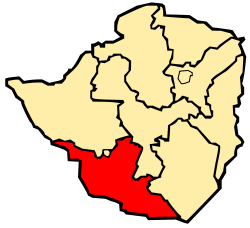
Matabeleland South
Encyclopedia

Provinces of Zimbabwe
|Zimbabwe is divided into 8 provinces and 2 cities with provincial status:-See also:*Districts of Zimbabwe*Municipalities of Zimbabwe*List of provincial governors of Zimbabwe*ISO 3166-2:ZW-External links:*...
of Zimbabwe
Zimbabwe
Zimbabwe is a landlocked country located in the southern part of the African continent, between the Zambezi and Limpopo rivers. It is bordered by South Africa to the south, Botswana to the southwest, Zambia and a tip of Namibia to the northwest and Mozambique to the east. Zimbabwe has three...
. It has an area of 54,172 km² and a population of approximately 650,000 (2002). Gwanda
Gwanda
Gwanda is the capital of the province of Matabeleland South in Zimbabwe. It is located on the Bulawayo-Beitbridge road and railway. Gwanda was founded in 1900. According to the 1982 Population Census, the town had a population of 4,874...
is the capital of the province.
Geography
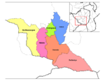
The province sits on the edge of the Kalahari desert, hence it is arid and very dry.Matabeleland South districts
The province is divided into 6 districts, BeitbridgeBeitbridge District
Situated in Matabeleland South, Zimbabwe's poorest province, Beitbridge lies on the border with South Africa, 527 kilometers south of Harare, 18 kilometers north of Messina and 548 kilometers north of Johannesburg. The town has a population of approximately 20,000 and serves a district of 80,000...
, Bulilimamangwe,
Gwanda
Gwanda District
Gwanda District is located in Matabeleland South Province of Zimbabwe.The center is Gwanda....
, Insiza, Matobo and Umzingwane.
See also
- Matabele people
- BulawayoBulawayoBulawayo is the second largest city in Zimbabwe after the capital Harare, with an estimated population in 2010 of 2,000,000. It is located in Matabeleland, 439 km southwest of Harare, and is now treated as a separate provincial area from Matabeleland...
- Provinces of ZimbabweProvinces of Zimbabwe|Zimbabwe is divided into 8 provinces and 2 cities with provincial status:-See also:*Districts of Zimbabwe*Municipalities of Zimbabwe*List of provincial governors of Zimbabwe*ISO 3166-2:ZW-External links:*...
- Districts of ZimbabweDistricts of ZimbabweThe provinces of Zimbabwe are divided into 59 districts and 1,200 municipalities. The districts are listed below, by province:-Bulawayo :* Bulawayo-Harare :* Harare-Manicaland Province:* Buhera* Chimanimani* Chipinge* Makoni* Mutare...