
Provinces of Zimbabwe
Encyclopedia
|
Zimbabwe
is divided into 8 province
s and 2 cities with provincial status:
Zimbabwe
Zimbabwe
Zimbabwe is a landlocked country located in the southern part of the African continent, between the Zambezi and Limpopo rivers. It is bordered by South Africa to the south, Botswana to the southwest, Zambia and a tip of Namibia to the northwest and Mozambique to the east. Zimbabwe has three...
is divided into 8 province
Province
A province is a territorial unit, almost always an administrative division, within a country or state.-Etymology:The English word "province" is attested since about 1330 and derives from the 13th-century Old French "province," which itself comes from the Latin word "provincia," which referred to...
s and 2 cities with provincial status:
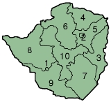
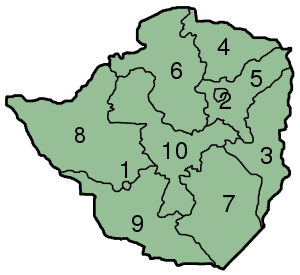
| Map key | Province | Capital |
|---|---|---|
| 1 | Bulawayo Bulawayo Bulawayo is the second largest city in Zimbabwe after the capital Harare, with an estimated population in 2010 of 2,000,000. It is located in Matabeleland, 439 km southwest of Harare, and is now treated as a separate provincial area from Matabeleland... |
city |
| 2 | Harare Harare Harare before 1982 known as Salisbury) is the largest city and capital of Zimbabwe. It has an estimated population of 1,600,000, with 2,800,000 in its metropolitan area . Administratively, Harare is an independent city equivalent to a province. It is Zimbabwe's largest city and its... |
city |
| 3 | Manicaland Manicaland Manicaland is a province of Zimbabwe. It has an area of and a population of approximately 1.6 million . Mutare is the capital of the province. -Background:... |
Mutare Mutare Mutare is the fourth largest city in Zimbabwe, with a population of around 170,000. It is the capital of Manicaland province.-History:... |
| 4 | Mashonaland Central Mashonaland Central Mashonaland Central is a province of Zimbabwe. It has an area of 28,347 km² and a population of approximately 998,265 , representing about 8.5% of the total Zimbabwe population.- Background :Bindura is the capital of the province... |
Bindura Bindura Bindura is a town in the province of Mashonaland Central, Zimbabwe. It is located in the Mazowe Valley about 88 km north-east of Harare. According to the 1982 Population Census, the town had a population of 18,243. This rose to 21,167 in the 1992 census. It is the administrative capital of the... |
| 5 | Mashonaland East Mashonaland East Mashonaland East is a province of Zimbabwe. It has an area of 32,230 km² and a population of approximately 1.1 million . Marondera is the capital of the province.-Districts:Mashonaland East is divided into eight districts:* Chikomba* Goromonzi... |
Marondera Marondera Marondera is a town in Mashonaland East, Zimbabwe, located about 72 km east of Harare; population 39,384... |
| 6 | Mashonaland West Mashonaland West Mashonaland West is a province of Zimbabwe. It has an area of 57,441 km² and a population of approximately 1.2 million . Chinhoyi is the capital of the province.Mashonaland West is divided into 6 districts:* Chegutu* Hurungwe* Kadoma* Kariba... |
Chinhoyi Chinhoyi Chinhoyi is a large provincial town and is the capital of Mashonaland West province in Zimbabwe. Sinoia was established in 1906 as a group settlement scheme by a wealthy Italian called Lieutenant Margherito Guidotti who encouraged 10 Italian families to settle there.- Overview :Chinhoyi is located... |
| 7 | Masvingo Province | Masvingo Masvingo Masvingo is a town in south-eastern Zimbabwe and the capital of Masvingo Province. The town is close to Great Zimbabwe, the national monument from which the country takes its name.- History :... |
| 8 | Matabeleland North Matabeleland North Matabeleland North is a province in western Zimbabwe. It borders the provinces of Midlands and Mashonaland West to the east and northeast respectively, and the province of Matabeleland South and the city of Bulawayo to the south. Its northern border is defined by the Zambezi river, while its... |
Lupane Lupane Lupane can refer to :*Lupane District in Zimbabwe*Lupane triterpenes... |
| 9 | Matabeleland South Matabeleland South Matabeleland South is a province of Zimbabwe. It has an area of 54,172 km² and a population of approximately 650,000 . Gwanda is the capital of the province.-Geography:... |
Gwanda Gwanda Gwanda is the capital of the province of Matabeleland South in Zimbabwe. It is located on the Bulawayo-Beitbridge road and railway. Gwanda was founded in 1900. According to the 1982 Population Census, the town had a population of 4,874... |
| 10 | Midlands Province | Gweru Gweru Gweru is a city near the centre of Zimbabwe at . It has a population of about 146,073 , making it the third largest city in the nation. Gweru is the capital of Midlands Province. Gweru was founded in 1894 by Dr. Leander Starr Jameson. The first bank opened in Gweru in 1896, and the stock exchange... |
 |
||
See also
- Districts of ZimbabweDistricts of ZimbabweThe provinces of Zimbabwe are divided into 59 districts and 1,200 municipalities. The districts are listed below, by province:-Bulawayo :* Bulawayo-Harare :* Harare-Manicaland Province:* Buhera* Chimanimani* Chipinge* Makoni* Mutare...
- Municipalities of ZimbabweMunicipalities of Zimbabwe|The Districts of Zimbabwe are divided into 1,200 municipal wards. The wards are listed below, by district:-Beitbridge:*Beitbridge*Chipise*Dendele*Dite Ii*Machuchuta*Maramani*Masera*Mtetengwe I*Mtetengwe Ii*Mtetengwe Iii*Siyoka I*Siyoka Ii...
- List of provincial governors of Zimbabwe
- ISO 3166-2:ZWISO 3166-2:ZWISO 3166-2:ZW is the entry for Zimbabwe in ISO 3166-2, part of the ISO 3166 standard published by the International Organization for Standardization , which defines codes for the names of the principal subdivisions of all countries coded in ISO 3166-1.Currently for Zimbabwe, ISO 3166-2 codes are...