

Downcutting
Encyclopedia
Geology
Geology is the science comprising the study of solid Earth, the rocks of which it is composed, and the processes by which it evolves. Geology gives insight into the history of the Earth, as it provides the primary evidence for plate tectonics, the evolutionary history of life, and past climates...
process that deepens the channel
Channel (geography)
In physical geography, a channel is the physical confine of a river, slough or ocean strait consisting of a bed and banks.A channel is also the natural or human-made deeper course through a reef, sand bar, bay, or any shallow body of water...
of a stream
Stream
A stream is a body of water with a current, confined within a bed and stream banks. Depending on its locale or certain characteristics, a stream may be referred to as a branch, brook, beck, burn, creek, "crick", gill , kill, lick, rill, river, syke, bayou, rivulet, streamage, wash, run or...
or valley
Valley
In geology, a valley or dale is a depression with predominant extent in one direction. A very deep river valley may be called a canyon or gorge.The terms U-shaped and V-shaped are descriptive terms of geography to characterize the form of valleys...
by removing material from the stream's bed or the valley's floor. How fast downcutting occurs depends on the stream's base level
Base level
The base level of a river or stream is the lowest point to which it can flow, often referred to as the 'mouth' of the river. For large rivers, sea level is usually the base level, but a large river or lake is likewise the base level for tributary streams...
, which is the lowest point to which the stream can erode
Erosion
Erosion is when materials are removed from the surface and changed into something else. It only works by hydraulic actions and transport of solids in the natural environment, and leads to the deposition of these materials elsewhere...
. Sea level
Sea level
Mean sea level is a measure of the average height of the ocean's surface ; used as a standard in reckoning land elevation...
is the ultimate base level, but many streams have a higher "temporary" base level because they empty into another body of water that is above sea level or encounter bedrock
Bedrock
In stratigraphy, bedrock is the native consolidated rock underlying the surface of a terrestrial planet, usually the Earth. Above the bedrock is usually an area of broken and weathered unconsolidated rock in the basal subsoil...
that resists erosion. A concurrent process called lateral erosion refers to the widening of a stream channel or valley. When a stream is high above its base level, downcutting will take place faster than lateral erosion; but as the level of the stream approaches its base level, the rate of lateral erosion increases. This is why streams in mountainous
Mountain
Image:Himalaya_annotated.jpg|thumb|right|The Himalayan mountain range with Mount Everestrect 58 14 160 49 Chomo Lonzorect 200 28 335 52 Makalurect 378 24 566 45 Mount Everestrect 188 581 920 656 Tibetan Plateaurect 250 406 340 427 Rong River...
areas tend to be narrow and swift, forming V-shaped valleys, while streams in lowland
Lowland
In physical geography, a lowland is any broad expanse of land with a general low level. The term is thus applied to the landward portion of the upward slope from oceanic depths to continental highlands, to a region of depression in the interior of a mountainous region, to a plain of denudation, or...
areas tend to be wide and slow-moving, with valleys that are correspondingly wide and flat-bottomed. The term gradient
Stream gradient
Stream gradient is the grade measured by the ratio of drop in a stream per unit distance, usually expressed as feet per mile or metres per kilometre.-Hydrology and geology:A high gradient indicates a steep slope and rapid flow of water Stream gradient is the grade (slope) measured by the ratio of...
refers to the elevation of a stream relative to its base level. The steeper the gradient, the faster the stream flows. Sometimes geological uplift
Tectonic uplift
Tectonic uplift is a geological process most often caused by plate tectonics which increases elevation. The opposite of uplift is subsidence, which results in a decrease in elevation. Uplift may be orogenic or isostatic.-Orogenic uplift:...
will increase the gradient of a stream even while the stream downcuts toward its base level, a process called "rejuvenation
Rejuvenation (river)
A river is said to be rejuvenated when the base level that it is flowing down to is lowered. This can happen for various reasons.-Signs:Rejuvenated terrains usually have complex landscapes because remnants of older landforms are locally preserved. Parts of floodplains may be preserved as terraces...
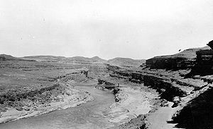
." This happened in the case of the Colorado River
Colorado River
The Colorado River , is a river in the Southwestern United States and northwestern Mexico, approximately long, draining a part of the arid regions on the western slope of the Rocky Mountains. The watershed of the Colorado River covers in parts of seven U.S. states and two Mexican states...
in the western United States
United States
The United States of America is a federal constitutional republic comprising fifty states and a federal district...
, resulting in the process that created the Grand Canyon
Grand Canyon
The Grand Canyon is a steep-sided canyon carved by the Colorado River in the United States in the state of Arizona. It is largely contained within the Grand Canyon National Park, the 15th national park in the United States...
.
Lake bed downcutting
LakeLake
A lake is a body of relatively still fresh or salt water of considerable size, localized in a basin, that is surrounded by land. Lakes are inland and not part of the ocean and therefore are distinct from lagoons, and are larger and deeper than ponds. Lakes can be contrasted with rivers or streams,...
bed downcutting is the erosion of cohesive material such as clay
Clay
Clay is a general term including many combinations of one or more clay minerals with traces of metal oxides and organic matter. Geologic clay deposits are mostly composed of phyllosilicate minerals containing variable amounts of water trapped in the mineral structure.- Formation :Clay minerals...
or glacial
Glacier
A glacier is a large persistent body of ice that forms where the accumulation of snow exceeds its ablation over many years, often centuries. At least 0.1 km² in area and 50 m thick, but often much larger, a glacier slowly deforms and flows due to stresses induced by its weight...
till
Till
thumb|right|Closeup of glacial till. Note that the larger grains in the till are completely surrounded by the matrix of finer material , and this characteristic, known as matrix support, is diagnostic of till....
from a shoreline by wave action. When the sand
Sand
Sand is a naturally occurring granular material composed of finely divided rock and mineral particles.The composition of sand is highly variable, depending on the local rock sources and conditions, but the most common constituent of sand in inland continental settings and non-tropical coastal...
cover is stripped away and the cohesive layer is exposed, cohesive material is lost to the water column. Unlike sand, cohesive material cannot be replenished by natural events such as bluff
Hill
A hill is a landform that extends above the surrounding terrain. Hills often have a distinct summit, although in areas with scarp/dip topography a hill may refer to a particular section of flat terrain without a massive summit A hill is a landform that extends above the surrounding terrain. Hills...
erosion. This can result in a process called "bluff recession," in which waves erode and carry away the material at the toe of the bluff and cause it to become steeper. When the slope reaches a certain angle, the bluff becomes unstable and fails, causing it to recede inland.