
Wansfell
Encyclopedia
.jpg)
Fell
“Fell” is a word used to refer to mountains, or certain types of mountainous landscape, in Scandinavia, the Isle of Man, and parts of northern England.- Etymology :...
in English Lake District
Lake District
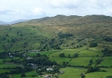
The Lake District, also commonly known as The Lakes or Lakeland, is a mountainous region in North West England. A popular holiday destination, it is famous not only for its lakes and its mountains but also for its associations with the early 19th century poetry and writings of William Wordsworth...
it is situated 2.5 kilometres east of the town of Ambleside
Ambleside
Ambleside is a town in Cumbria, in North West England.Historically within the county of Westmorland, it is situated at the head of Windermere, England's largest lake...
. The fell is part of the long southern ridge of Caudale Moor and occupies the swathe of territory between Ambleside and the Troutbeck valley.
Topography
Wansfell has an extensive summit ridge with two tops, the highest point of the fell is called Baystones with a height of 488 m (1,601 ft) while Wansfell Pike, which lies a kilometre to the south west reaches an altitude of 482 m (1,581 ft). Of the two summits Wansfell Pike is regarded as the “true” summit of the fell by many fell walkers because of its superior view, even though it is the lower of the pair.Despite its modest altitude, Wansfell has significant topographic prominence
Topographic prominence
In topography, prominence, also known as autonomous height, relative height, shoulder drop , or prime factor , categorizes the height of the mountain's or hill's summit by the elevation between it and the lowest contour line encircling it and no higher summit...
being linked to the higher fell of Caudale Moor by a col near the Kirstone Pass road (A 592) with the height of around 339.2 metres giving the fell prominence of 147.7 metres, which means it just fails to achieve the necessary prominence to be a Marilyn
Marilyn (hill)
A Marilyn is a mountain or hill in the United Kingdom, Republic of Ireland or Isle of Man with a relative height of at least 150 metres , regardless of absolute height or other merit...
.
The summit was deleted from the original list of Marilyns in 1999 but was re-instated due to a change in the recorded summit position. A team including John Barnard surveyed the hill on 18 September 2009 and on 11 February 2010 announced that the summit and col height measurements were 486.9m and 339.2m respectively, and thus it was once again removed from the list of Marilyns.
Wansfell has strong connections to Ambleside and is seen as very much belonging to the town, with Bill Birkett
Bill Birkett
Bill Birkett is one of the world's foremost mountain writers and photographers, and is a leading climber who has undertaken many expeditions around the world....
saying “Wansfell is to Ambleside what St. Pauls is to London”. The popularity of the ascent from Ambleside led to severe erosion which became so bad that the path underwent restoration work in the late 1990s using stone blocks and sections of the path now resemble a stone staircase.
Name
The fells name is thought to originate from the Old NorseOld Norse
Old Norse is a North Germanic language that was spoken by inhabitants of Scandinavia and inhabitants of their overseas settlements during the Viking Age, until about 1300....
language and can draw a parallel with Wansdyke
Wansdyke (earthwork)
Wansdyke is a series of early medieval defensive linear earthworks in the West Country of England, consisting of a ditch and a running embankment from the ditch spoil, with the ditching facing north. It runs at least from Maes Knoll in historic Somerset, a hillfort at the east end of Dundry Hill...
in Somerset in that it is named after the main Norse god and means “Wodens
Odin
Odin is a major god in Norse mythology and the ruler of Asgard. Homologous with the Anglo-Saxon "Wōden" and the Old High German "Wotan", the name is descended from Proto-Germanic "*Wodanaz" or "*Wōđanaz"....
Fell”.
Fell Race
Wansfell hosts a popular short fell raceFell running
Fell running, also known as mountain running and hill running, is the sport of running and racing, off road, over upland country where the gradient climbed is a significant component of the difficulty...
which takes place annually between Christmas and the New Year, the winning runner usually takes around 20 minutes to complete the four kilometre course.
Ascents
The fell is predominately ascended from Ambleside using the road which leaves the town centre and goes past Stockghyll Force waterfall before bearing right onto the restored footpath which is followed to the summit. An ascent is also possible from Troutbeck, on the eastern side of the fell, following a farm track called Nanny Lane until the open fell is reached from where it is an easy climb to the summit.Wansfell is on the route of the Windermere Way
Windermere Way
The Windermere Way is a 45 mile circuit of Windermere, a lake in the English Lake District. The route is wholly within the Lake District National Park and takes in the summits of Wansfell, Loughrigg Fell and Gummer's How as well as passing through the towns of Ambleside and Windermere.-History and...
, a long distance path that circumambulates Lake Windermere.
Summits and View
The fell's two summits are linked by a dry stoneDry stone
Dry stone is a building method by which structures are constructed from stones without any mortar to bind them together. Dry stone structures are stable because of their unique construction method, which is characterized by the presence of a load-bearing facade of carefully selected interlocking...
wall, Wansfell Pike is the lower of the two but has a more attractive rocky top and a better view, with Windermere
Windermere (lake)
Windermere is the largest natural lake in England. It is a ribbon lake formed in a glacial trough after the retreat of ice at the start of the current interglacial. It has been one of the country’s most popular places for holidays and summer homes since the arrival of the Kendal and Windermere...
looking particularly attractive to the south. The highest point (Baystones) is a grassy hummock marked by a few stones.