
Gray Crag
Encyclopedia
Topography
The fellFell
“Fell” is a word used to refer to mountains, or certain types of mountainous landscape, in Scandinavia, the Isle of Man, and parts of northern England.- Etymology :...
reaches a height of 699 metres (2,293 feet) at the northern end of its summit ridge and this is the accepted highest point which gives the best views, although there is a spot height of 710 metres (2,329 feet) less than a kilometre to the south. Both tops have small cairn
Cairn
Cairn is a term used mainly in the English-speaking world for a man-made pile of stones. It comes from the or . Cairns are found all over the world in uplands, on moorland, on mountaintops, near waterways and on sea cliffs, and also in barren desert and tundra areas...
s set on grass. Gray Crag is located in the far eastern sector of the national park, five kilometres south east of the village of Patterdale
Patterdale
Patterdale is a small village and civil parish in the eastern part of the English Lake District in the Eden District of Cumbria, and the long valley in which they are found, also called the Ullswater Valley....
and is basically the narrow grassy northern ridge of the adjoining fell of Thornthwaite Crag
Thornthwaite Crag
Thornthwaite Crag is a fell in the English Lake District, standing to the west of Haweswater Reservoir. It is a focal point of the Far Eastern Fells, standing at the head of several valleys.-Topography:...
, it is characterised by very steep flanks with crags and gullies which fall away towards Hayeswater
Hayeswater
Hayeswater is a small lake within the Lake District of Cumbria, England.The lake is situated about a mile SE of the hamlet of Hartsop in the Patterdale Valley. It nestles between The Knott to its west and Gray Crag to the east and it is at an altitude of almost 1,400 feet . The lake is natural...
on the eastern side and Pasture Beck to the west. This fell should not be confused with Grey Crag
Grey Crag
Grey Crag is a fell in the English Lake District. It stands to the east of Longsleddale in the Far Eastern Fells. There is another fell named Gray Crag in the Lake District near Hartsop.-Topography:...
another Lakeland Fell also in the far eastern sector above Longsleddale
Longsleddale
Longsleddale is a valley and civil parish in the South Lakeland district of the English county of Cumbria. It includes the hamlet of Sadgill. The parish has a population of 73....
.
Ascents
Gray Crag is invariably ascended from the hamlet of HartsopHartsop
Hartsop is a small village in the English Lake District. It lies in the Patterdale valley, near Brothers Water, Hayeswater and Kirkstone Pass.It consists of 17th Century grey stone cottages, like so many of its neighbours. Hartsop retains its historic image, in that, in common with a number of...
where there is a car park, Hayeswater Gill is followed for 1.5 kilometres until the filter house just below Hayeswater is reached, the steep grassy northern ridge of Gray Crag is then ascended passing a rocky outcrop before reaching the flatter plateau and then the summit. An alternative from the same starting point is to follow Pasture Beck up to the head of the valley at Threshthwaite Mouth and then contour round onto Gray Crag. Alfred Wainwright
Alfred Wainwright
Alfred Wainwright MBE was a British fellwalker, guidebook author and illustrator. His seven-volume Pictorial Guide to the Lakeland Fells, published between 1955 and 1966 and consisting entirely of reproductions of his manuscript, has become the standard reference work to 214 of the fells of the...
gave this as his preferred route. Most walkers will continue their walk along the ridge south to Thornthwaite Crag which is two kilometres away and return to Hartsop over Caudale Moor and Hartsop Dodd
Hartsop Dodd
Hartsop Dodd is a fell in the English Lake District, standing to the south east of Brothers Water. It is a subsidiary top on the north ridge of Caudale Moor, but was given separate fell status by Wainwright in his Pictorial Guide to the Lakeland Fells...
.
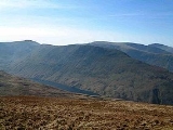
View
The view from the top gives a good aspect of the Helvellyn rangeHelvellyn range
Helvellyn range is the name given to a part of the Eastern Fells in the English Lake District, fell being the local word for hill. The name comes from Helvellyn, the highest point of the group....
but more spectacular views can be obtained by walking to the edges of the ridge and looking down into the valleys on either side.