
Staunton, Gloucestershire
Encyclopedia

Forest of Dean
The Forest of Dean is a geographical, historical and cultural region in the western part of the county of Gloucestershire, England. The forest is a roughly triangular plateau bounded by the River Wye to the west and north, the River Severn to the south, and the City of Gloucester to the east.The...
in west Gloucestershire
Gloucestershire
Gloucestershire is a county in South West England. The county comprises part of the Cotswold Hills, part of the flat fertile valley of the River Severn, and the entire Forest of Dean....
, England
England
England is a country that is part of the United Kingdom. It shares land borders with Scotland to the north and Wales to the west; the Irish Sea is to the north west, the Celtic Sea to the south west, with the North Sea to the east and the English Channel to the south separating it from continental...
.
This entry is for the one near Coleford
Coleford, Gloucestershire
Coleford is a small market town in Gloucestershire, England in the west of the Forest of Dean with a population of 8,351 . It is situated some four miles east of the Welsh border, and is close to the Wye Valley, a popular walking and canoeing area...
. (The other is on the A417 some 7 miles north of Gloucester
Gloucester
Gloucester is a city, district and county town of Gloucestershire in the South West region of England. Gloucester lies close to the Welsh border, and on the River Severn, approximately north-east of Bristol, and south-southwest of Birmingham....
, which does not yet have an entry).
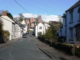
Location
Staunton is located three miles north east of MonmouthMonmouth
Monmouth is a town in southeast Wales and traditional county town of the historic county of Monmouthshire. It is situated close to the border with England, where the River Monnow meets the River Wye with bridges over both....
and four miles north west of Coleford
Coleford, Gloucestershire
Coleford is a small market town in Gloucestershire, England in the west of the Forest of Dean with a population of 8,351 . It is situated some four miles east of the Welsh border, and is close to the Wye Valley, a popular walking and canoeing area...
in the Forest of Dean
Forest of Dean
The Forest of Dean is a geographical, historical and cultural region in the western part of the county of Gloucestershire, England. The forest is a roughly triangular plateau bounded by the River Wye to the west and north, the River Severn to the south, and the City of Gloucester to the east.The...
, on the border of England and Wales
Wales
Wales is a country that is part of the United Kingdom and the island of Great Britain, bordered by England to its east and the Atlantic Ocean and Irish Sea to its west. It has a population of three million, and a total area of 20,779 km²...
. The main road which passes through Staunton is the A4136 road.
History
The name Staunton comes from the Old English words Stane (as in Stane StreetStane Street
There are several Roman Stane Streets - see also Stane Street Stane Street is the modern name given to an important long Roman road in England that linked London to the Roman town of Noviomagus Reginorum, or Regnentium, later renamed Chichester by the Saxons...
) and Tun
Tun
- Science and technology :* TUN/TAP, a computer network device driver* TUN , a Danish product standard for building materials* Tun , a part of the Mayan long count calendar system* A unit of time in the Mayan Long Count calendar...
meaning 'stony farmstead' or settlement. Stane also refers to six other significant and notable stones that lie within the parish
Parish
A parish is a territorial unit historically under the pastoral care and clerical jurisdiction of one parish priest, who might be assisted in his pastoral duties by a curate or curates - also priests but not the parish priest - from a more or less central parish church with its associated organization...
including a rocky outcrop, called the Frog or Toad's Mouth at the west end of the village. The Long Stone, a pillar of rock or possible standing stone
Standing stone
Standing stones, orthostats, liths, or more commonly megaliths are solitary stones set vertically in the ground and come in many different varieties....
which may date from before 1700 BC, is visible on the Coleford road. The Broad Stone is the largest of several rocks in the fields of Broadstone farm. The Buckstone is situated nearby, as are the Suck Stone and the Near Hearkening Rock.
There is little documented history of the parish of Staunton before 1100. Plenty of evidence of Neolithic
Neolithic
The Neolithic Age, Era, or Period, or New Stone Age, was a period in the development of human technology, beginning about 9500 BC in some parts of the Middle East, and later in other parts of the world. It is traditionally considered as the last part of the Stone Age...
man has been unearthed over the years in the form of flint cores from weapons and flint tool chipping. It is known that the Romans
Roman Britain
Roman Britain was the part of the island of Great Britain controlled by the Roman Empire from AD 43 until ca. AD 410.The Romans referred to the imperial province as Britannia, which eventually comprised all of the island of Great Britain south of the fluid frontier with Caledonia...
moved iron ore from local mines down to Blestium
Blestium
Blestium was a small town and probable fort in Roman Wales within the Roman province of Britannia Superior, part of Roman Britain...
(Monmouth), probably on the ancient route lying below and to the east of the present A4136 road between Staunton and Monmouth. After the Romans left, Staunton remained as one or two farmsteads.
Edward the Confessor
Edward the Confessor
Edward the Confessor also known as St. Edward the Confessor , son of Æthelred the Unready and Emma of Normandy, was one of the last Anglo-Saxon kings of England and is usually regarded as the last king of the House of Wessex, ruling from 1042 to 1066....
was the first English
England
England is a country that is part of the United Kingdom. It shares land borders with Scotland to the north and Wales to the west; the Irish Sea is to the north west, the Celtic Sea to the south west, with the North Sea to the east and the English Channel to the south separating it from continental...
King to designate the area between the River Severn
River Severn
The River Severn is the longest river in Great Britain, at about , but the second longest on the British Isles, behind the River Shannon. It rises at an altitude of on Plynlimon, Ceredigion near Llanidloes, Powys, in the Cambrian Mountains of mid Wales...
and the River Wye
River Wye
The River Wye is the fifth-longest river in the UK and for parts of its length forms part of the border between England and Wales. It is important for nature conservation and recreation.-Description:...
, as the "King’s Forest", a Royal Forest
Royal forest
A royal forest is an area of land with different meanings in England, Wales and Scotland; the term forest does not mean forest as it is understood today, as an area of densely wooded land...
.
Staunton is mentioned in the Domesday Book
Domesday Book
Domesday Book , now held at The National Archives, Kew, Richmond upon Thames in South West London, is the record of the great survey of much of England and parts of Wales completed in 1086...
as one farmstead and a waste or meend. It is probable that the first Norman
Normans
The Normans were the people who gave their name to Normandy, a region in northern France. They were descended from Norse Viking conquerors of the territory and the native population of Frankish and Gallo-Roman stock...
Lord of the manor
Lord of the Manor
The Lordship of a Manor is recognised today in England and Wales as a form of property and one of three elements of a manor that may exist separately or be combined and may be held in moieties...
arrived in about 1100, and a fortified manor house was built above Castle Ditch. The parish church
Parish church
A parish church , in Christianity, is the church which acts as the religious centre of a parish, the basic administrative unit of episcopal churches....
was also initially built at this time. The church originally had a paved path leading out of the porchway direct in a straight route to the main road. During the 1980's, this was altered. The original entrance to the graveyard was replaced with a right angled route instead.
The church has 6 bells, which over the years has been of some interest to campanologists. There have been many bellringing clubs in the past, training new bellringers to ring for local weddings and funerals.
Opposite the village hall is a Pound, where lost sheep would be kept. When farmers collected their sheep, they would have to pay for their release. This is now a frequent place for the Summer fete to be held.
In 1608 there were 50 houses in the village of Staunton. A muster roll for the parish includes one labourer, two miners, three farmers, one lime burner, one husbandryman, two blacksmiths, one carpenter and a tyler, with others making a total of 35 - this is for fighting men (when called) with weapons in the parish. This would mean that there were about 150 residents altogether.
Deposits of iron ore in the parish were being dug in 1608 and various small mines provided work during the 18th century. In 1871 Robinhood’s mine in the Marian's Enclosure, was opened and was worked mainly for red oxide. It produced iron ore for several years before it closed in 1932. The Ministry of Supply
Ministry of Supply
The Ministry of Supply was a department of the UK Government formed in 1939 to co-ordinate the supply of equipment to all three British armed forces, headed by the Minister of Supply. There was, however, a separate ministry responsible for aircraft production and the Admiralty retained...
gave it a short lease of life when they opened it up during the Second World War.
In 1664 there was a limekiln
Limekiln
A lime kiln is used to produce quicklime through the calcination of limestone . The chemical equation for this reaction is...
on waste land near the church, and in 1792 one at a quarry at Tillys, which grew to 3 in the 19th century. From the 1950s the quarry on the ridge of the plantations north of Highmeadow above Cherry Orchard Farm was worked for road stone. By 1994, it was operated and enlarged by Tarmac
Tarmac (company)
Tarmac is a company that is based in Wolverhampton in the United Kingdom and operates internationally. The company produces aggregates and road-surfacing materials, including tarmacadam, from which the company's name is derived...
Ltd., and a new access road was made through the woods to the Coleford - Monmouth road.
In 1799 the village had one inn, The Ostrich, which became the Royal Oak in 1832. In 1813 competition arrived as the White Horse opened in the west part of the village street, which later became the main road. It publicised itself as the last Inn in England. The White Horse, which was rebuilt in the latter part of the 19th century, is now the only public house as the Ostrich closed in the 1890s.
Below the White Horse was a Nursery with large greenhouses on the area stretching from the pub car park to the high House open until the 1970s – this site is now built on.
At the beginning of the 19th century a parish day-school was held in Staunton church for around 20 children. In 1828 a small single-room school was built near the east end of the main village street. This school was closed in 1911 and the building used as a reading room. Subsequently it has been used as the Village Hall.
The old Post office – no longer standing - was on the main road on the corner of what is now Well Meadow. It relocated to the opposite side of the road and was combined with a village shop where today there is an Architectural Antique Shop. The Post Office relocated itself again next to High House but closed in the early 1990s. Staunton used to have a petrol filling station where there is now a vehicle repair business.
The 1960s the Elms nursing home was a working dairy farm. It became the nursing home in the 1980s.
Opposite the church is a large collection of buildings which were the granary and mill. This building had a windmill in the small field outside, although this has now gone. Next to this, an Elms House was built. Ths was used for any person 'in need' from the village to live in. This may have been due to illness, elderly age or in financial needs.
The Whippington Brook Road is the old road to Christchurch and in this area there has been infill housing amongst the now mostly privately owned former council houses, from Whippington's Corner leading onto Forest Close cul-de-sac. The Old Rectory and it's outbuildings, which date from the 17th Century, were split up into separate freeholds in the late 1980s, and the Coach House and Tithe Barn
Tithe barn
A tithe barn was a type of barn used in much of northern Europe in the Middle Ages for storing the tithes - a tenth of the farm's produce which had to be given to the church....
converted into residential properties.
The village has one the Bledisloe Cup for 'Best Kept Village' twice, a highly acclaimed judged competition.
Surroundings and amenities
Staunton is known for being surrounded by stones such as the Buckstone, the Suckstone and the Near Hearkening Rock. The best known stone and a local landmark is the Buckstone. When Lord Nelson and Lady Hamilton visited MonmouthMonmouth
Monmouth is a town in southeast Wales and traditional county town of the historic county of Monmouthshire. It is situated close to the border with England, where the River Monnow meets the River Wye with bridges over both....
and district, it was painted white in their honour. Up to the middle of the 19th century it used to rock on its base - however in June 1885 a party of five travelling actors from the London Star Company and the landlord at the Agincourt Inn in Monmouth, having enjoyed an evening of sampling fine wines, managed to dislodge the stone and send it crashing down the slope. It split into several pieces, but was hauled back up the hill at great cost and to prevent further vandalisation was cemented together in place and no longer rocks.
The Suckstone is reputed to be the largest piece of detached conglomerate
Conglomerate (geology)
A conglomerate is a rock consisting of individual clasts within a finer-grained matrix that have become cemented together. Conglomerates are sedimentary rocks consisting of rounded fragments and are thus differentiated from breccias, which consist of angular clasts...
or puddingstone rock
Puddingstone (rock)
Puddingstone, also known as either Pudding stone or Plum-pudding stone, is a popular name applied to a conglomerate that consists of distinctly rounded pebbles whose colors contrast sharply with the color of the finer-grained, often sandy, matrix or cement surrounding them...
in England and Wales and has been estimated to weigh maybe 14,000 tons. It is possible to climb this huge stone at the bottom right hand corner.
The Near Hearkening Rock is a large exposed and weathered cliff face of Old Red Sandstone
Old Red Sandstone
The Old Red Sandstone is a British rock formation of considerable importance to early paleontology. For convenience the short version of the term, 'ORS' is often used in literature on the subject.-Sedimentology:...
and quartz
Quartz
Quartz is the second-most-abundant mineral in the Earth's continental crust, after feldspar. It is made up of a continuous framework of SiO4 silicon–oxygen tetrahedra, with each oxygen being shared between two tetrahedra, giving an overall formula SiO2. There are many different varieties of quartz,...
conglomerate and reputedly was given its name by local gamekeepers who used it to detect poachers in their woods at night, both as an observation platform and as a listening post and it is reputedly possible to detect even a whisper or the slightest movement such are the acoustics in this area while standing with your back to the concave cliff face or on the top of the cliff.
It is the first village in the Forest of Dean
Forest of Dean
The Forest of Dean is a geographical, historical and cultural region in the western part of the county of Gloucestershire, England. The forest is a roughly triangular plateau bounded by the River Wye to the west and north, the River Severn to the south, and the City of Gloucester to the east.The...
when approached from Monmouthshire, sited high above Monmouth
Monmouth
Monmouth is a town in southeast Wales and traditional county town of the historic county of Monmouthshire. It is situated close to the border with England, where the River Monnow meets the River Wye with bridges over both....
and the River Wye
River Wye
The River Wye is the fifth-longest river in the UK and for parts of its length forms part of the border between England and Wales. It is important for nature conservation and recreation.-Description:...
. The English
England
England is a country that is part of the United Kingdom. It shares land borders with Scotland to the north and Wales to the west; the Irish Sea is to the north west, the Celtic Sea to the south west, with the North Sea to the east and the English Channel to the south separating it from continental...
-Welsh
Wales
Wales is a country that is part of the United Kingdom and the island of Great Britain, bordered by England to its east and the Atlantic Ocean and Irish Sea to its west. It has a population of three million, and a total area of 20,779 km²...
border and Offa's Dyke Path
Offa's Dyke Path
Offa's Dyke Path is a long distance footpath along the Welsh-English border. Opened in 1971, it is one of Britain's premier National Trails and draws walkers from throughout the world...
pass close to the village. The Wysis Way
Wysis Way
The Wysis Way is a 88km walking route which forms a link between the Offa's Dyke and Thames Path national trails in the United Kingdom. The Way runs between Monmouth and Kemble, Gloucestershire.-Route Detail:...
runs through the back of Staunton and goes from Monmouth to Gloucester
Gloucester
Gloucester is a city, district and county town of Gloucestershire in the South West region of England. Gloucester lies close to the Welsh border, and on the River Severn, approximately north-east of Bristol, and south-southwest of Birmingham....
. It links up with Offa's Dyke path and the Thames Path
Thames Path
The Thames Path is a National Trail, opened in 1996, following the length of the River Thames from its source near Kemble in Gloucestershire to the Thames Barrier at Charlton. It is about long....
.
In the churchyard is the grave of David Mushet
David Mushet
David Mushet was a Scottish metallurgist and the youngest son of Margaret Cochran and William Mushet.-Early life:Mushet was born on October 2, 1772, in Dalkeith, near Edinburgh. He was educated at Dalkeith Grammar School....
(1772-1847), a noted Scottish
Scotland
Scotland is a country that is part of the United Kingdom. Occupying the northern third of the island of Great Britain, it shares a border with England to the south and is bounded by the North Sea to the east, the Atlantic Ocean to the north and west, and the North Channel and Irish Sea to the...
metallurgist
Metallurgy
Metallurgy is a domain of materials science that studies the physical and chemical behavior of metallic elements, their intermetallic compounds, and their mixtures, which are called alloys. It is also the technology of metals: the way in which science is applied to their practical use...
, who built Darkhill Ironworks
Darkhill Ironworks
Darkhill Ironworks, and the neighbouring Titanic Steelworks, are internationally important industrial remains associated with the development of the iron and steel industries. Both are scheduled monuments. They are located on the edge of a small hamlet called Gorsty Knoll, just to the west of...
and who, with his son
Robert Forester Mushet
Robert Forester Mushet was a British metallurgist and businessman, born April 8, 1811, in Coleford, in the Forest of Dean, Gloucestershire, England. He was the youngest son of Scottish parents, Agnes Wilson and David Mushet; an ironmaster, formerly of the Clyde, Alfreton and Whitecliff...
, greatly advanced the iron and steel industries.
Village activities
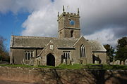
Parish church
A parish church , in Christianity, is the church which acts as the religious centre of a parish, the basic administrative unit of episcopal churches....
is All Saints.
A local Bed & Breakfast is called Steep Meadow. The old octagonal village pound
Pound (village)
The Village pound was a feature of most British medieval villages.A high walled and lockable structure it served several purposes; the most common use was to hold stray sheep, pigs and cattle until they were claimed by the owners, usually for the payment of a fine or levy. The pound could be as...
is just past the village hall
Village hall
In the United States, a village hall is the seat of government for villages. It functions much as a city hall does within cities.In the United Kingdom, a village hall is usually a building within a village which contains at least one large room, usually owned by and run for the benefit of the local...
where there is some seating and views.
There was a thriving Horticultural Show held each year, this was followed by the Staunton Country Fayre which ran very successfully for many years - the last one being in 2005.
The village hall today is the meeting place for the village art group, book group, Harvest Suppers, sewing classes, the Garden Club, Table Tennis Club, keep fit, Pantos, Musical Evenings and Parish Council meetings. It holds many events throughout the year.