
Thames Path
Encyclopedia

River Thames
The River Thames flows through southern England. It is the longest river entirely in England and the second longest in the United Kingdom. While it is best known because its lower reaches flow through central London, the river flows alongside several other towns and cities, including Oxford,...
from its source near Kemble
Kemble, Gloucestershire
Kemble is a village in Gloucestershire, England.It lies four miles from Cirencester and is the settlement closest to Thames Head, the source of the River Thames. Kemble Church is part of the Thameshead benefice, comprising the communities of Kemble, Ewen, Poole Keynes, Somerford Keynes, and...
in Gloucestershire
Gloucestershire
Gloucestershire is a county in South West England. The county comprises part of the Cotswold Hills, part of the flat fertile valley of the River Severn, and the entire Forest of Dean....
to the Thames Barrier
Thames Barrier
The Thames Barrier is the world's second-largest movable flood barrier and is located downstream of central London. Its purpose is to prevent London from being flooded by exceptionally high tides and storm surges moving up from the sea...
at Charlton
Charlton, London
Charlton is a district of south London, England, and part of the London Borough of Greenwich. It is located east-southeast of Charing Cross. Charlton next Woolwich was an ancient parish in the county of Kent, which became part of the metropolitan area of London in 1855. It is home to Charlton...
. It is about 184 miles (296.1 km) long.
The entire length of the path can be walked, and some parts cycled. Most of the path uses the original towpath
Towpath
A towpath is a road or trail on the bank of a river, canal, or other inland waterway. The purpose of a towpath is to allow a land vehicle, beasts of burden, or a team of human pullers to tow a boat, often a barge...
but in some places this is not possible. The main reason for this is that towpath traffic used to cross the river at several points using ferries, but apart from Shepperton to Weybridge Ferry
Shepperton to Weybridge Ferry
The Shepperton to Weybridge Ferry is a pedestrian and cycle ferry service across the River Thames in the English county of Surrey. The ferry runs from Ferry Lane, in Shepperton, to a point a short walk from Thames Street, in Weybridge. It is situated just below Shepperton Lock on the reach above...
these no longer operate. This means that in several places such as Shiplake
Shiplake
Shiplake is a village and civil parish about south of Henley-on-Thames in Oxfordshire, England on the River Thames.-History:The Church of England parish church of St. Peter and St. Paul dates from at least the 13th century, but in 1869 the Gothic Revival architect G.E. Street rebuilt the chancel,...
, Whitchurch-on-Thames
Whitchurch-on-Thames
Whitchurch-on-Thames is a village and civil parish on the Oxfordshire bank of the River Thames, about northwest of Reading, Berkshire. Opposite Whitchurch on the Berkshire bank is the village of Pangbourne.-History:...
and Moulsford
Moulsford
Moulsford is a village and civil parish in South Oxfordshire. In 1974 it was transferred from Berkshire to the county of Oxfordshire, and from Wallingford Rural District to the district of South Oxfordshire....
, there are diversions away from the towpath. At other places, there are replacement connections. An example of this is at Hurley
Hurley, Berkshire
Hurley is a village and civil parish in the English county of Berkshire.Hurley is famous for its proximity to the River Thames. It is also within easy reach of Henley-on-Thames, Oxford and London. The parish includes the villages and hamlets of Cockpole Green, Warren Row, Knowl Hill, Burchett's...
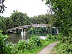
, where the Temple Footbridge
Temple Footbridge
Temple Footbridge is a pedestrian bridge near Hurley, Berkshire across the River Thames in England. It connects the Buckinghamshire and Berkshire banks. It crosses the Thames just above Temple Lock....
was built in 1989.
Some parts of the Thames Path, particularly those west of Oxford
Oxford
The city of Oxford is the county town of Oxfordshire, England. The city, made prominent by its medieval university, has a population of just under 165,000, with 153,900 living within the district boundary. It lies about 50 miles north-west of London. The rivers Cherwell and Thames run through...
, are subject to flooding during the winter months. The river is tidal downstream from Teddington Lock
Teddington Lock
Teddington Lock is a complex of three locks and a weir on the River Thames in England at Ham in the western suburbs of London. The lock is on the southern Surrey side of the river....
, and parts of the path may be underwater if there is a particularly high tide
High Tide
High Tide was a band formed in 1969 by Tony Hill , Simon House , Peter Pavli and Roger Hadden .-History:...
.
The London Thames Cycle Route is a mapped (and black signposted) route that follows the river between Putney Bridge in the west and Greenwich in the east. This follows the majority of the Thames Path, but does divert in various sections. Especially where the Path follows a footpath only route. It also links National Cycle Route 1 (east of London) with National Cycle Route 4 (west of London).
Route
The route can be divided into sections as follows:- Thames HeadThames HeadThames Head is a site in Gloucestershire, traditionally identified as the source of the River Thames, a major river which runs through the centre of London. It lies near the village of Kemble and the town of Cirencester....
(source of the river west of CrickladeCrickladeCricklade is a town and civil parish on the River Thames in north Wiltshire in England, midway between Swindon and Cirencester.On 25 September 2011 Cricklade was awarded The Royal Horticultural Society's 'Champion of Champions' award in the Britain in Bloom competition.Cricklade is twinned with...
) to OxfordOxfordThe city of Oxford is the county town of Oxfordshire, England. The city, made prominent by its medieval university, has a population of just under 165,000, with 153,900 living within the district boundary. It lies about 50 miles north-west of London. The rivers Cherwell and Thames run through...
(54 mi (86.9 km)): a generally rural, agricultural area, where the river is sometimes difficult to follow, particularly until LechladeLechladeLechlade, or Lechlade-on-Thames, is a town at the southern edge of the Cotswolds in Gloucestershire, England. It is the highest point at which the River Thames is navigable. The town is named after the River Leach that joins the Thames near here....
(23 mi (37 km)) is reached. - Oxford to Henley-on-ThamesHenley-on-ThamesHenley-on-Thames is a town and civil parish on the River Thames in South Oxfordshire, England, about 10 miles downstream and north-east from Reading, 10 miles upstream and west from Maidenhead...
(51 mi (82.1 km)): passing through AbingdonAbingdon, OxfordshireAbingdon or archaically Abingdon-on-Thames is a market town and civil parish in Oxfordshire, England. It is the seat of the Vale of White Horse district. Previously the county town of Berkshire, Abingdon is one of several places that claim to be Britain's oldest continuously occupied town, with...
, DorchesterDorchester, OxfordshireDorchester-on-Thames is a village and civil parish on the River Thame in Oxfordshire, about northwest of Wallingford and southeast of Oxford. Despite its name, Dorchester is not on the River Thames, but just above the Thame's confluence with it...
, Wallingford, StreatleyStreatley, BerkshireStreatley is a village and civil parish on the River Thames in Berkshire, England.-Location:Streatley is about from Reading and from Oxford. It is in the Goring Gap on the River Thames and is directly across the river from the Oxfordshire village of Goring-on-Thames...
and ReadingReading, BerkshireReading is a large town and unitary authority area in England. It is located in the Thames Valley at the confluence of the River Thames and River Kennet, and on both the Great Western Main Line railway and the M4 motorway, some west of London....
: the walk leaves the river bank through the towns, and crosses from one bank to another at various places. - Henley to WindsorWindsor, BerkshireWindsor is an affluent suburban town and unparished area in the Royal Borough of Windsor and Maidenhead in Berkshire, England. It is widely known as the site of Windsor Castle, one of the official residences of the British Royal Family....
: (23 mi (37 km)): through MarlowMarlow, BuckinghamshireMarlow is a town and civil parish within Wycombe district in south Buckinghamshire, England...
and MaidenheadMaidenheadMaidenhead is a town and unparished area within the Royal Borough of Windsor and Maidenhead, in Berkshire, England. It lies on the River Thames and is situated west of Charing Cross in London.-History:...
. The path leaves the river on some occasions. - Windsor to Richmond (28 mi (45.1 km)): along the edge of a portion of Windsor Great ParkWindsor Great ParkWindsor Great Park is a large deer park of , to the south of the town of Windsor on the border of Berkshire and Surrey in England. The park was, for many centuries, the private hunting ground of Windsor Castle and dates primarily from the mid-13th century...
; past RunnymedeRunnymedeRunnymede is a water-meadow alongside the River Thames in the English county of Berkshire, and just over west of central London. It is notable for its association with the sealing of Magna Carta, and as a consequence is the site of a collection of memorials...
; through Hampton Court Park. The path leaves the river to make way for residential areas at times. - Richmond to the Thames Barrier (28 mi (45.1 km)): Passing Kew Gardens and the Wetlands Centre at Barnes then through London, using parkland (e.g., Battersea ParkBattersea ParkBattersea Park is a 200 acre green space at Battersea in the London Borough of Wandsworth in England. It is situated on the south bank of the River Thames opposite Chelsea, and was opened in 1858....
) to continue beside the river. Through most of the section, the Thames Path is actually two paths, one on either side of the river. - Thames Barrier to Crayford Ness, just beyond ErithErithErith is a district of southeast London on the River Thames. Erith's town centre has undergone a series of modernisations since 1961.-Pre-medieval:...
(10 mi (16.1 km)), connecting with the London Outer Orbital PathLondon Outer Orbital PathThe London Outer Orbital Path — more usually the "London LOOP" — is a signed walk along public footpaths, and through parks, woods and fields around the edge of Outer London, England, described as "the M25 for walkers"...
. This is considered an extension of the Thames Path (as recognised by the Ramblers Association) and was opened in 2001, but is not part of the National Trail. It has its own Thames Barge symbol, and is sometimes referred to as the Thames Path Southeast Extension.
The path is one of those included in the Mayor of London
Mayor of London
The Mayor of London is an elected politician who, along with the London Assembly of 25 members, is accountable for the strategic government of Greater London. Conservative Boris Johnson has held the position since 4 May 2008...
's Strategic walking routes.
Thames crossings
Cricklade
Cricklade is a town and civil parish on the River Thames in north Wiltshire in England, midway between Swindon and Cirencester.On 25 September 2011 Cricklade was awarded The Royal Horticultural Society's 'Champion of Champions' award in the Britain in Bloom competition.Cricklade is twinned with...
and Teddington
Teddington
Teddington is a suburban area in the London Borough of Richmond upon Thames in south west London, on the north bank of the River Thames, between Hampton Wick and Twickenham. It stretches inland from the River Thames to Bushy Park...
. Above Cricklade the Thames is a stream and in some places there may be no water except after rain. Below Teddington there are paths on both sides of the river until the Greenwich foot tunnel
Greenwich foot tunnel
The Greenwich foot tunnel is a pedestrian tunnel crossing beneath the River Thames in East London, linking Greenwich in the south with the Isle of Dogs to the north...
, after which the path is only on the south. The letter in brackets indicates whether the path downstream of that point is on the northern or southern bank (using north or south in reference to the river as a whole, rather than at that specific point). Bridge
Bridge
A bridge is a structure built to span physical obstacles such as a body of water, valley, or road, for the purpose of providing passage over the obstacle...
s and ferries are listed in full under Crossings of the River Thames
Crossings of the River Thames
This is a list of crossings of the River Thames including bridges, tunnels and ferries. There are 214 bridges, over 20 tunnels, six public ferries and one ford.-Barrier and boundary:...
. Islands are listed under Islands in the River Thames
Islands in the River Thames
This article lists the islands in the River Thames, in England. It excludes many of the smaller lock islands that were created when weirs and locks were built, and also some very small islands that immediately adjoin the larger ones. The Isle of Dogs and Isle of Grain are no longer islands although...
.
- CrickladeCrickladeCricklade is a town and civil parish on the River Thames in north Wiltshire in England, midway between Swindon and Cirencester.On 25 September 2011 Cricklade was awarded The Royal Horticultural Society's 'Champion of Champions' award in the Britain in Bloom competition.Cricklade is twinned with...
(S) - Eysey FootbridgeEysey FootbridgeEysey Footbridge is a footbridge across the River Thames in England, just above Cricklade, Wiltshire near Eysey Manor. It is one of the first bridges on the Thames Path. The River Key joins the Thames just upstream of the bridge.-References:...
(N) - Water Eaton House BridgeWater Eaton House BridgeWater Eaton House Bridge is a footbridge across the River Thames in Wiltshire, England. It is situated between Cricklade and Castle Eaton near Water Eaton House. It is one of the first bridges on the Thames Path....
(S) - Bloomers Hole FootbridgeBloomers Hole FootbridgeBloomers Hole Footbridge is a footbridge across the River Thames in Oxfordshire, England. It is situated on the reach above Buscot Lock and was installed in 2000 to carry the Thames Path across the Thames...
(N) - Radcot BridgeRadcot BridgeRadcot Bridge is a crossing of the River Thames in England, south of Radcot, Oxfordshire and not far north of Faringdon, Oxfordshire . It carries the A4095 road across the river on the reach above Radcot Lock...
(S) - Tadpole BridgeTadpole BridgeTadpole Bridge is a road bridge across the River Thames in Oxfordshire, England, carrying a road between Bampton to the north and Buckland to the south. It crosses the Thames on the reach above Shifford Lock....
(N) - Tenfoot BridgeTenfoot BridgeTenfoot Bridge is a wooden footbridge across the River Thames in Oxfordshire, England. It is situated on the reach above Shifford Lock and was built in 1869. It connects Buckland on the south bank to Chimney on the north....
(S) - Newbridge, OxfordshireNewbridge, OxfordshireNewbridge is a 13th century bridge carrying the A415 road over the River Thames in Oxfordshire, between Abingdon and Witney, close to the Thames' confluence with the River Windrush...
(N) - Pinkhill LockPinkhill LockPinkhill Lock is a lock on the River Thames in England. It is close to Farmoor, Oxfordshire.The first lock was built of stone by Daniel Harris for the Thames Navigation Commission in 1791....
(S) - Fiddler's IslandFiddler's IslandFiddler's Island is an island in the River Thames at Oxford in England. It is situated south of Port Meadow on the reach above Osney Lock.The thin island sits between the Thames and Castle Mill Stream. On the south of the island a short stream known as the Sheepwash Channel divides the island from...
(N) - Osney BridgeOsney BridgeOsney Bridge is a road bridge across the River Thames in Oxford, England, built in 1889 to replace a stone bridge which collapsed in 1885. It carries the Botley Road from Botley into Oxford...
(S) - Abingdon LockAbingdon LockAbingdon Lock is a lock on the River Thames in England, less than 1 mile east and upstream of Abingdon, Oxfordshire on the opposite bank of the river...
(N) - Clifton Hampden BridgeClifton Hampden BridgeClifton Hampden Bridge is a road bridge crossing the River Thames in Clifton Hampden, Oxfordshire, England, situated on the reach below Clifton Lock. Originally it joined Oxfordshire on the north bank with Berkshire on the south but in 1974 the area on the south bank was transferred from Berkshire...
(S) - Day's LockDay's LockDay's Lock is a lock on the River Thames near Dorchester-on-Thames, Oxfordshire, England on the Dorchester side of the river.The pound lock was built in 1789 by the Thames Navigation Commissioner...
(N) - Benson LockBenson LockBenson Lock is a lock on the River Thames in England, close to Benson, Oxfordshire but on the opposite bank of the river. The first pound lock here was built by the Thames Navigation Commission in 1788 and it was replaced by the present masonry lock in 1870...
(S) - Goring and Streatley BridgeGoring and Streatley BridgeGoring and Streatley Bridge is a road bridge across the River Thames in England. The bridge links the twin villages of Goring-On-Thames, Oxfordshire, and Streatley, Berkshire, and is adjacent to Goring Lock....
(N) - Whitchurch BridgeWhitchurch BridgeWhitchurch Bridge is a toll road bridge over the River Thames in England. It carries the road between the villages of Pangbourne, Berkshire, and Whitchurch-on-Thames, Oxfordshire, and crosses the river on the reach above Mapledurham Lock, just before Whitchurch Lock...
(S) - Sonning BridgeSonning BridgeSonning Bridge is a road bridge across the River Thames at Sonning, Berkshire. It links Sonning with Sonning Eye and crosses the Thames on the reach above Shiplake Lock, just short of Sonning Lock. It is a brick arch bridge completed in 1775, to replace an earlier wooden bridge...
(N) - Henley BridgeHenley BridgeHenley Bridge is a five-elliptical-arched stone road bridge built in 1786 at Henley-on-Thames over the River Thames, between Oxfordshire and Berkshire. The bridge links Hart Street in Henley with White Hill leading up a steep hill to Remenham Hill...
(S) - Temple FootbridgeTemple FootbridgeTemple Footbridge is a pedestrian bridge near Hurley, Berkshire across the River Thames in England. It connects the Buckinghamshire and Berkshire banks. It crosses the Thames just above Temple Lock....
(N) - Bourne End Railway BridgeBourne End Railway BridgeBourne End Railway Bridge is a railway bridge carrying the Marlow Branch Line, and a footpath over the River Thames in Bourne End, Buckinghamshire, England. It crosses the Thames on the reach between Cookham Lock and Marlow Lock....
(S) - Maidenhead BridgeMaidenhead BridgeMaidenhead Bridge is a Grade I listed bridge carrying the A4 road over the River Thames between Maidenhead, Berkshire and Taplow, Buckinghamshire, England. It crosses the Thames on the reach above Bray Lock, about half a mile below Boulter's Lock.-History:...
(N) - Windsor BridgeWindsor BridgeWindsor Bridge or Windsor Town Bridge, is a road bridge over the River Thames between the towns of Windsor and Eton in the English county of Berkshire. It now only carries pedestrian and cycle traffic, and crosses the Thames just above Romney Lock....
(S) - Victoria Bridge, DatchetVictoria Bridge, DatchetVictoria Bridge is a road bridge running North/South between Datchet and Windsor, Berkshire, England. It crosses the River Thames on the reach between Old Windsor Lock and Romney Lock...
(N) - Albert Bridge, DatchetAlbert Bridge, DatchetAlbert Bridge is a road bridge in England running North/South between Datchet and Old Windsor. It crosses the River Thames on the reach between Old Windsor Lock and Romney Lock...
(S) - Staines BridgeStaines BridgeStaines Bridge is a road bridge running in a south-west to north-east direction across the River Thames in Surrey. It is on the modern A308 road and links the boroughs of Spelthorne and Runnymede at Staines and Egham Hythe....
(N) - Shepperton to Weybridge FerryShepperton to Weybridge FerryThe Shepperton to Weybridge Ferry is a pedestrian and cycle ferry service across the River Thames in the English county of Surrey. The ferry runs from Ferry Lane, in Shepperton, to a point a short walk from Thames Street, in Weybridge. It is situated just below Shepperton Lock on the reach above...
(S) - Hampton Court BridgeHampton Court BridgeHampton Court Bridge crosses the River Thames in England in a north to south direction between Hampton, Greater London and East Molesey, Surrey. It is on the reach above Teddington Lock and about hundred yards upstream of the bridge is Molesey Lock....
(N) - Kingston Bridge, LondonKingston Bridge, LondonKingston Bridge is a road bridge at Kingston upon Thames in London, England, carrying the A308 across the River Thames. It joins the town centre of Kingston in the Royal Borough of Kingston upon Thames, to Hampton Court Park, Bushy Park, and the village of Hampton Wick in the London Borough of...
(S) - Teddington Lock Footbridges
The reverse direction of the path going upstream on the non-tidal part is obtainable by following the locks up from Teddington Lock. Between Teddington Lock and Lechlade the locks divide the river into reaches and a description of the reach above each lock includes the route of the Thames Path going upstream. Locks are listed under Locks on the River Thames
Locks on the River Thames
The English River Thames is navigable from Cricklade or Lechlade to the sea, and this part of the river falls 71 metres . There are 45 locks on the river, each with one or more adjacent weirs...
.