
.gif)
State Route 520 (Washington)
Encyclopedia
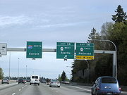
State Route 520 is a state highway and freeway in the U.S. state
of Washington. It extends 12.82 miles (20.6 km) from Seattle in the west to Redmond
in the east.
just south of Roanoke Park
.
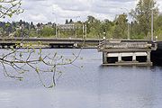
It bridges Portage Bay
on a viaduct, crosses through the Montlake
neighborhood, and continues east on a causeway
through the marshlands of the Washington Park Arboretum
and across Foster Island. From there it crosses Lake Washington
on the Evergreen Point Floating Bridge
(1963) to Medina
. At 7,578 feet (2,310m), it is the longest floating bridge
in the world.
From Medina
, it traces the border between Hunts Point
and Yarrow Point
to the north, and Clyde Hill
to the south. Intersecting with Interstate 405
in Bellevue
, it then runs into Redmond
. It bisects the Microsoft
campus, passes Nintendo of America
headquarters and crosses the Sammamish River
and Bear Creek, before ending at a junction with State Route 202
. A set of ramps connecting SR-520 to Avondale Road NE were completed in 1996.
The original name of the freeway in planning documents was the Roanoke Expressway and later the Roanoke Freeway, due to its terminus at Interstate 5 near Roanoke Street and Roanoke Park
in Seattle.
).
In the 1963 and 1967 revisions of the King County Streets and Highways Plan, SR-520 appears in its entirety. The segment from I-5 to I-405 is shown as existing or "to be improved"; the segment from I-405 to SR-202 is shown as "proposed".
The 1967 Puget Sound Regional Council of Governments recommended freeway system omits the segment from I-405 to SR-202, replacing it with a freeway from the Sand Point-Kirkland bridge (then proposed as a third Lake Washington crossing) along the current route of SR-908, deviating southward near West Lake Sammamish Parkway to end at the current SR-520 terminus. In this plan, SR-520 ends at I-405.
All planning maps from 1974 onward show the SR-520 routing as it currently exists.
in August 1963, SR-520 opened to traffic. Originally, it was legislatively defined as PSH-1 EP (Primary State Highway 1, Evergreen Point branch). The road was signed as PSH-1 without the branch designation.
When the new numbering system for Washington highways took effect in 1964, SR-520 ran from I-5 to the junction of Lake Washington Boulevard NE and Lincoln Avenue (now Bellevue Way).
 The segment from I-405 to 148th Avenue NE opened in the early 1970s. In the mid-1970s, the segment between West Lake Sammamish Parkway and SR-202 opened with the route number State Route 920 as a Super-2
freeway. This segment was widened to a divided 4-lane freeway by 1990.
The final segment of SR-520 between 148th Avenue NE and West Lake Sammamish Parkway opened circa 1979. At this time, SR-920 was redesignated as SR-520.
In 1973, the right-side shoulder of westbound SR-520 from Bellevue Way to the Evergreen Point Floating Bridge
was converted for use as a transit-only lane, so that buses could bypass the tollbooths for the bridge. The existing general-purpose lanes were narrowed to accommodate the conversion. In the late 1980s, the lane was redesignated as a HOV lane for carpools of 3 or more, in addition to transit use.
In the 1990s, both sides of SR-520 from the I-405
interchange to W Lake Sammamish Parkway were widened to add a HOV lane on both sides, and collector-distributor lanes were added from NE 40th Street to W Lake Sammamish Parkway. A new interchange was built at NE 40th Street to accommodate expansion of the Microsoft
and Nintendo of America
corporate campuses.
between West Lake Sammamish Parkway - known at the time as State Route 901
, and State Route 202
in Redmond
. The original roadway was a 4 lane undivided link road between the two highways. SR 520 had only been completed to 148th Ave NE when SR 920 was constructed. When the missing link between 148th Ave NE and SR 901 was completed in the early 1980s, SR 920 was replaced by the SR 520 designation. However upon completion, there was a short section crossing SR 901 where SR 520 narrowed to one lane, and then immediately back to two. This section of SR 520 was widened and a new interchange was built at the junction of SR 520, SR 202, and Avondale Road - the former eastern terminus of SR 920.
 SR 520 features a set of ghost ramps in the marshlands of Washington Park Arboretum. They are often referred to as "ramps to nowhere". However, there are 2 ramps currently used for the Westbound 520 off ramp connection to the Washington Park Arboretum while the other serves as an on ramp only to SR 520 Eastbound. The others are unused. They were originally part of a plan to build the R. H. Thomson Expressway which would have cut through the arboretum and down through Seattle towards the I-90/I-5 interchange. Citizens rallied a freeway revolt against the plan on May 4, 1969. Construction near the Arboretum later continued but citizen protest eventually won out and the plan was dropped in 1971.
The freeway revolt
that stopped the R. H. Thomson Expressway had its origins in opposition to SR 520 itself. Architect Victor Steinbrueck, writing in 1962, objected to the "naked brutality of unimaginative structures such as this proposed crossing of Portage Bay, which eliminates fifty houseboats while casting its shadow and noise across this tranquil boat haven."
.
U.S. state
A U.S. state is any one of the 50 federated states of the United States of America that share sovereignty with the federal government. Because of this shared sovereignty, an American is a citizen both of the federal entity and of his or her state of domicile. Four states use the official title of...
of Washington. It extends 12.82 miles (20.6 km) from Seattle in the west to Redmond
Redmond, Washington
Redmond is a city in King County, Washington, United States, located east of Seattle. The population was 54,144 at the 2010 census,up from 45,256 in 2000....
in the east.
Route description
SR-520 originates at Interstate 5 in Seattle at the north end of Capitol HillCapitol Hill, Seattle, Washington
Capitol Hill is the most densely populated residential district in Seattle, Washington, United States. It is the center of the city's gay and counterculture communities, and is one of the city's most prominent nightlife and entertainment districts....
just south of Roanoke Park
Roanoke Park (Seattle)
Roanoke Park is a 2.2 acre park on north Capitol Hill in Seattle, Washington. It occupies the block bounded by E. Edgar and Roanoke Streets on the north and south and 10th Avenue E. and Broadway E. on the east and west, just northeast of the junction of State Route 520 and Interstate 5.The park...
.
It bridges Portage Bay
Portage Bay
Portage Bay is an arm of Seattle, Washington's Lake Union and is part of the Lake Washington Ship Canal. Its western limit can be said to be the Ship Canal Bridge, which carries Interstate 5 over the water; North Passage Point Park and South Passage Point Park sit on opposite shores between the...
on a viaduct, crosses through the Montlake
Montlake, Seattle, Washington
Montlake is an affluent residential neighborhood in central Seattle. It is bounded to the north by Portage Bay and the Montlake Cut section of the Lake Washington Ship Canal, to the east by the Washington Park Arboretum, and to the south and west by Interlaken Park. Capitol Hill is on its south and...
neighborhood, and continues east on a causeway
Causeway
In modern usage, a causeway is a road or railway elevated, usually across a broad body of water or wetland.- Etymology :When first used, the word appeared in a form such as “causey way” making clear its derivation from the earlier form “causey”. This word seems to have come from the same source by...
through the marshlands of the Washington Park Arboretum
Washington Park Arboretum
Washington Park is a public park in Seattle, Washington, USA, most of which is taken up by the Washington Park Arboretum, a joint project of the University of Washington, the Seattle Department of Parks and Recreation, and the nonprofit Arboretum Foundation. Washington Park also includes a...
and across Foster Island. From there it crosses Lake Washington
Lake Washington
Lake Washington is a large freshwater lake adjacent to the city of Seattle. It is the largest lake in King County and the second largest in the state of Washington, after Lake Chelan. It is bordered by the cities of Seattle on the west, Bellevue and Kirkland on the east, Renton on the south and...
on the Evergreen Point Floating Bridge
Evergreen Point Floating Bridge
The Governor Albert D. Rosellini Bridge—Evergreen Point is the longest floating bridge on Earth at and carries State Route 520 across Lake Washington from Seattle to Medina.The Evergreen Point of the bridge's original name is the westernmost of the three small Eastside...
(1963) to Medina
Medina, Washington
Medina is a city located in the Eastside, a region of King County, Washington, United States. Surrounded on the north, west, and south by Lake Washington, opposite Seattle, Medina is bordered by Clyde Hill and Hunts Point, as well as the satellite city of Bellevue. The city's population was 2,969...
. At 7,578 feet (2,310m), it is the longest floating bridge
Pontoon bridge
A pontoon bridge or floating bridge is a bridge that floats on water and in which barge- or boat-like pontoons support the bridge deck and its dynamic loads. While pontoon bridges are usually temporary structures, some are used for long periods of time...
in the world.
From Medina
Medina, Washington
Medina is a city located in the Eastside, a region of King County, Washington, United States. Surrounded on the north, west, and south by Lake Washington, opposite Seattle, Medina is bordered by Clyde Hill and Hunts Point, as well as the satellite city of Bellevue. The city's population was 2,969...
, it traces the border between Hunts Point
Hunts Point, Washington
Hunts Point is a town located in the Eastside, a region of King County, Washington, United States, and part of the Seattle metropolitan area. The town is located on a small peninsula surrounded by Lake Washington, and is near the suburbs of Medina , Clyde Hill , Yarrow Point , and Kirkland , as...
and Yarrow Point
Yarrow Point, Washington
Yarrow Point is a town in King County, Washington, United States. The population was 1,001 at the 2010 census.Based on per capita income, one of the more reliable measures of affluence, Yarrow Point ranks fifth of 522 areas in the state of Washington to be ranked.-Geography:Yarrow Point is located...
to the north, and Clyde Hill
Clyde Hill, Washington
Clyde Hill is a city located in the Eastside, a region of King County, Washington, United States, and part of the Seattle metropolitan area. The town of Kirkland lies to the northeast, while the satellite city of Bellevue is located to the east and south. Lake Washington is also nearby, providing...
to the south. Intersecting with Interstate 405
Interstate 405 (Washington)
Interstate 405 in Washington is a stretch of freeway that bypasses Seattle east of Lake Washington. The northern terminus is in Lynnwood and the southern terminus is in Tukwila...
in Bellevue
Bellevue, Washington
Bellevue is a city in the Eastside region of King County, Washington, United States, across Lake Washington from Seattle. Long known as a suburb or satellite city of Seattle, it is now categorized as an edge city or a boomburb. The population was 122,363 at the 2010 census.Downtown Bellevue is...
, it then runs into Redmond
Redmond, Washington
Redmond is a city in King County, Washington, United States, located east of Seattle. The population was 54,144 at the 2010 census,up from 45,256 in 2000....
. It bisects the Microsoft
Microsoft
Microsoft Corporation is an American public multinational corporation headquartered in Redmond, Washington, USA that develops, manufactures, licenses, and supports a wide range of products and services predominantly related to computing through its various product divisions...
campus, passes Nintendo of America
Nintendo
is a multinational corporation located in Kyoto, Japan. Founded on September 23, 1889 by Fusajiro Yamauchi, it produced handmade hanafuda cards. By 1963, the company had tried several small niche businesses, such as a cab company and a love hotel....
headquarters and crosses the Sammamish River
Sammamish River
The Sammamish River flows through north King County, Washington for about , draining Lake Sammamish into Lake Washington...
and Bear Creek, before ending at a junction with State Route 202
State Route 202 (Washington)
State Route 202, also known as SR 202, is a highway in the state of Washington, U.S.A. It runs southeast for , from State Route 522 in Woodinville to Interstate 90 in North Bend. SR 202 is entirely within King County.- Route description:...
. A set of ramps connecting SR-520 to Avondale Road NE were completed in 1996.
The original name of the freeway in planning documents was the Roanoke Expressway and later the Roanoke Freeway, due to its terminus at Interstate 5 near Roanoke Street and Roanoke Park
Roanoke Park (Seattle)
Roanoke Park is a 2.2 acre park on north Capitol Hill in Seattle, Washington. It occupies the block bounded by E. Edgar and Roanoke Streets on the north and south and 10th Avenue E. and Broadway E. on the east and west, just northeast of the junction of State Route 520 and Interstate 5.The park...
in Seattle.
Planning
SR-520 first appears on planning maps in the late 1950s. It is not in the 1956 Comprehensive Plan of Seattle, in which the preferred second bridge crossing of Lake Washington connects Sand Point and Juanita (now part of KirklandKirkland, Washington
Kirkland is a city in King County, Washington, United States. It is a suburb of Seattle on the Eastside . The population was 48,787 at the 2010 census makes it the 9th largest city in King County and the 20th largest city in the state...
).
In the 1963 and 1967 revisions of the King County Streets and Highways Plan, SR-520 appears in its entirety. The segment from I-5 to I-405 is shown as existing or "to be improved"; the segment from I-405 to SR-202 is shown as "proposed".
The 1967 Puget Sound Regional Council of Governments recommended freeway system omits the segment from I-405 to SR-202, replacing it with a freeway from the Sand Point-Kirkland bridge (then proposed as a third Lake Washington crossing) along the current route of SR-908, deviating southward near West Lake Sammamish Parkway to end at the current SR-520 terminus. In this plan, SR-520 ends at I-405.
All planning maps from 1974 onward show the SR-520 routing as it currently exists.
Construction
With the completion of the Evergreen Point Floating BridgeEvergreen Point Floating Bridge
The Governor Albert D. Rosellini Bridge—Evergreen Point is the longest floating bridge on Earth at and carries State Route 520 across Lake Washington from Seattle to Medina.The Evergreen Point of the bridge's original name is the westernmost of the three small Eastside...
in August 1963, SR-520 opened to traffic. Originally, it was legislatively defined as PSH-1 EP (Primary State Highway 1, Evergreen Point branch). The road was signed as PSH-1 without the branch designation.
When the new numbering system for Washington highways took effect in 1964, SR-520 ran from I-5 to the junction of Lake Washington Boulevard NE and Lincoln Avenue (now Bellevue Way).
Two-lane freeway
A two-lane expressway is an expressway with only one lane in each direction, and usually no median barrier. It may be built that way because of constraints, or may be intended for expansion once traffic volumes rise. The term super two is often used by roadgeeks for this type of road, but traffic...
freeway. This segment was widened to a divided 4-lane freeway by 1990.
The final segment of SR-520 between 148th Avenue NE and West Lake Sammamish Parkway opened circa 1979. At this time, SR-920 was redesignated as SR-520.
In 1973, the right-side shoulder of westbound SR-520 from Bellevue Way to the Evergreen Point Floating Bridge
Evergreen Point Floating Bridge
The Governor Albert D. Rosellini Bridge—Evergreen Point is the longest floating bridge on Earth at and carries State Route 520 across Lake Washington from Seattle to Medina.The Evergreen Point of the bridge's original name is the westernmost of the three small Eastside...
was converted for use as a transit-only lane, so that buses could bypass the tollbooths for the bridge. The existing general-purpose lanes were narrowed to accommodate the conversion. In the late 1980s, the lane was redesignated as a HOV lane for carpools of 3 or more, in addition to transit use.
In the 1990s, both sides of SR-520 from the I-405
Interstate 405 (Washington)
Interstate 405 in Washington is a stretch of freeway that bypasses Seattle east of Lake Washington. The northern terminus is in Lynnwood and the southern terminus is in Tukwila...
interchange to W Lake Sammamish Parkway were widened to add a HOV lane on both sides, and collector-distributor lanes were added from NE 40th Street to W Lake Sammamish Parkway. A new interchange was built at NE 40th Street to accommodate expansion of the Microsoft
Microsoft
Microsoft Corporation is an American public multinational corporation headquartered in Redmond, Washington, USA that develops, manufactures, licenses, and supports a wide range of products and services predominantly related to computing through its various product divisions...
and Nintendo of America
Nintendo
is a multinational corporation located in Kyoto, Japan. Founded on September 23, 1889 by Fusajiro Yamauchi, it produced handmade hanafuda cards. By 1963, the company had tried several small niche businesses, such as a cab company and a love hotel....
corporate campuses.
State Route 920
State Route 920 was a temporary designation of what is now part of State Route 520State Route 520 (Washington)
State Route 520 is a state highway and freeway in the U.S. state of Washington. It extends from Seattle in the west to Redmond in the east.-Route description:...
between West Lake Sammamish Parkway - known at the time as State Route 901
State Route 901 (Washington)
State Route 901, commonly known as SR 901 or Highway 901, was a state highway in the U.S. state of Washington. SR 901 was created in 1964 and was decommissioned in 1992.- History :SR 901 was created in 1964 from Secondary State Highway 2D...
, and State Route 202
State Route 202 (Washington)
State Route 202, also known as SR 202, is a highway in the state of Washington, U.S.A. It runs southeast for , from State Route 522 in Woodinville to Interstate 90 in North Bend. SR 202 is entirely within King County.- Route description:...
in Redmond
Redmond, Washington
Redmond is a city in King County, Washington, United States, located east of Seattle. The population was 54,144 at the 2010 census,up from 45,256 in 2000....
. The original roadway was a 4 lane undivided link road between the two highways. SR 520 had only been completed to 148th Ave NE when SR 920 was constructed. When the missing link between 148th Ave NE and SR 901 was completed in the early 1980s, SR 920 was replaced by the SR 520 designation. However upon completion, there was a short section crossing SR 901 where SR 520 narrowed to one lane, and then immediately back to two. This section of SR 520 was widened and a new interchange was built at the junction of SR 520, SR 202, and Avondale Road - the former eastern terminus of SR 920.
Completed improvements
- The flyover ramp from westbound State Route 202State Route 202 (Washington)State Route 202, also known as SR 202, is a highway in the state of Washington, U.S.A. It runs southeast for , from State Route 522 in Woodinville to Interstate 90 in North Bend. SR 202 is entirely within King County.- Route description:...
to SR-520 opened in Spring 2008. - SR-520 between Bellevue Way and the Evergreen Point Floating Bridge was paved with several types of quiet asphalt pavement as a test bed in Fall 2007.
- Ramps connecting the end of SR-520 from SR-202State Route 202 (Washington)State Route 202, also known as SR 202, is a highway in the state of Washington, U.S.A. It runs southeast for , from State Route 522 in Woodinville to Interstate 90 in North Bend. SR 202 is entirely within King County.- Route description:...
to Avondale Road were completed in 1996. - An overpass was constructed connecting NE 36th Street and NE 31st Street on the MicrosoftMicrosoftMicrosoft Corporation is an American public multinational corporation headquartered in Redmond, Washington, USA that develops, manufactures, licenses, and supports a wide range of products and services predominantly related to computing through its various product divisions...
campus. The bridge was completed in December 2010. Microsoft provided almost half of the funding for this bridge.
Ongoing improvements
Because of massive residential, commercial, and industrial growth in the Eastside over the past 15 years, several projects have been proposed to improve the entire stretch of State Route 520.- Replacement of the Evergreen Point Floating BridgeEvergreen Point Floating BridgeThe Governor Albert D. Rosellini Bridge—Evergreen Point is the longest floating bridge on Earth at and carries State Route 520 across Lake Washington from Seattle to Medina.The Evergreen Point of the bridge's original name is the westernmost of the three small Eastside...
and freeway expansion to 6 lanes (2 general-purpose/1 HOV per side) between Interstate 5 and Interstate 405. On April 17, 2009, the House granted the WSDOT authority to impose a toll on the existing bridge to generate funding for its replacement. As of August 2011August 2011'August 2011 was the eighth month of the current year. It began on a Monday and ended after 31 days on a Wednesday.- Portal:Current events :This is an archived version of Wikipedia's Current events Portal from August 2011. ...
, the toll has yet to be activated due to technical difficulties with the toll collection equipment. - Freeway expansion to 8 lanes (2 general-purpose/1 HOV/1 auxiliary lane per side) between West Lake Sammamish Parkway and State Route 202State Route 202 (Washington)State Route 202, also known as SR 202, is a highway in the state of Washington, U.S.A. It runs southeast for , from State Route 522 in Woodinville to Interstate 90 in North Bend. SR 202 is entirely within King County.- Route description:...
, along with widening existing ramps between SR-202State Route 202 (Washington)State Route 202, also known as SR 202, is a highway in the state of Washington, U.S.A. It runs southeast for , from State Route 522 in Woodinville to Interstate 90 in North Bend. SR 202 is entirely within King County.- Route description:...
and Avondale Road to 2 lanes.) - Eastbound collector-distributor lanes between Interstate 405 and 124th Avenue NE as part of I-405 braided-ramp improvements between NE 8th Street and SR-520 in BellevueBellevue, WashingtonBellevue is a city in the Eastside region of King County, Washington, United States, across Lake Washington from Seattle. Long known as a suburb or satellite city of Seattle, it is now categorized as an edge city or a boomburb. The population was 122,363 at the 2010 census.Downtown Bellevue is...
.
Proposed improvements
- A flyover ramp from westbound SR-520 to southbound Interstate 405Interstate 405 (Washington)Interstate 405 in Washington is a stretch of freeway that bypasses Seattle east of Lake Washington. The northern terminus is in Lynnwood and the southern terminus is in Tukwila...
is currently deferred due to lack of construction funds. - The Sound Transit 2 proposal would add a Bus Rapid Transit (BRT) line to the entire SR-520 corridor, and a light rail extension joining the corridor in the vicinity of Overlake, continuing to the Overlake Transit Center on the MicrosoftMicrosoftMicrosoft Corporation is an American public multinational corporation headquartered in Redmond, Washington, USA that develops, manufactures, licenses, and supports a wide range of products and services predominantly related to computing through its various product divisions...
campus.
Ghost ramps
The freeway revolt
Freeway and expressway revolts
Many freeway revolts took place in developed countries during the 1960s and 1970s, in response to plans for the construction of new freeways, a significant number of which were abandoned or significantly scaled back due to widespread public opposition; especially of those whose neighborhoods would...
that stopped the R. H. Thomson Expressway had its origins in opposition to SR 520 itself. Architect Victor Steinbrueck, writing in 1962, objected to the "naked brutality of unimaginative structures such as this proposed crossing of Portage Bay, which eliminates fifty houseboats while casting its shadow and noise across this tranquil boat haven."
Exit list
The entire route is in King CountyKing County, Washington
King County is a county located in the U.S. state of Washington. The population in the 2010 census was 1,931,249. King is the most populous county in Washington, and the 14th most populous in the United States....
.
| Location | Mile | Destinations | Notes |
|---|---|---|---|
| Seattle | 0.00 | – Portland Portland, Oregon Portland is a city located in the Pacific Northwest, near the confluence of the Willamette and Columbia rivers in the U.S. state of Oregon. As of the 2010 Census, it had a population of 583,776, making it the 29th most populous city in the United States... , Vancouver Vancouver Vancouver is a coastal seaport city on the mainland of British Columbia, Canada. It is the hub of Greater Vancouver, which, with over 2.3 million residents, is the third most populous metropolitan area in the country,... |
Westbound exit and eastbound entrance |
| 0.19 | Roanoke Street, Harvard Avenue | Westbound exit only | |
| 0.94 | Montlake Boulevard (SR 513) – University of Washington University of Washington University of Washington is a public research university, founded in 1861 in Seattle, Washington, United States. The UW is the largest university in the Northwest and the oldest public university on the West Coast. The university has three campuses, with its largest campus in the University... |
||
| 1.31 | Lake Washington Boulevard | Westbound exit and eastbound entrance | |
| 3.07 | Evergreen Point Floating Bridge Evergreen Point Floating Bridge The Governor Albert D. Rosellini Bridge—Evergreen Point is the longest floating bridge on Earth at and carries State Route 520 across Lake Washington from Seattle to Medina.The Evergreen Point of the bridge's original name is the westernmost of the three small Eastside... over Lake Washington Lake Washington Lake Washington is a large freshwater lake adjacent to the city of Seattle. It is the largest lake in King County and the second largest in the state of Washington, after Lake Chelan. It is bordered by the cities of Seattle on the west, Bellevue and Kirkland on the east, Renton on the south and... |
||
| Medina | |||
| Hunts Point | 4.59 | 84th Avenue Northeast | Eastbound exit and westbound entrance |
| Yarrow Point, Clyde Hill |
5.17 | 92nd Avenue Northeast | Westbound exit and eastbound entrance |
| Bellevue Bellevue, Washington Bellevue is a city in the Eastside region of King County, Washington, United States, across Lake Washington from Seattle. Long known as a suburb or satellite city of Seattle, it is now categorized as an edge city or a boomburb. The population was 122,363 at the 2010 census.Downtown Bellevue is... |
5.97 | Bellevue Way Northeast, Lake Washington Boulevard Northeast | Eastbound exit and westbound entrance; former SR 908 |
| 6.27 | 108th Avenue Northeast | No eastbound exit | |
| 6.93 | |||
| 7.52 | 124th Avenue Northeast | Eastbound exit and westbound entrance | |
| 9.17 | 148th Avenue Northeast | ||
| Redmond Redmond, Washington Redmond is a city in King County, Washington, United States, located east of Seattle. The population was 54,144 at the 2010 census,up from 45,256 in 2000.... |
|||
| 10.13 | Northeast 40th Street | The Northeast 40th Street interchange was not part of the original SR-520 plan but was constructed circa 1998. | |
| 10.73 | Northeast 51st Street | Completed in 1986. | |
| 11.79 | West Lake Sammamish Parkway Northeast | Former SR 901 | |
| 12.73 | |||
| 12.82 | Avondale Road | Continuation beyond SR 202 | |