
.gif)
State Highway 17 (Texas)
Encyclopedia
State Highway 17, or SH 17, runs from Marfa
to Pecos
in west Texas
. The road is maintained by the Texas Department of Transportation (TxDOT)
.
, passes through Jeff Davis County
, and terminates at Pecos in Reeves County
.
 The route begins at intersection of San Antonio Street and Highland Avenue. In Marfa, San Antonio St. is US 90. US 67 enters intersection from the south along S. Highland Ave. then turns east along E. San Antonio St. becoming concurrent
with US 90. SH 17 proceeds north along Highland Ave.
After two blocks, SH 17 intersects the beginning of Farm to Market Road 1112
which proceeds eastward along E. Oak St. which runs parallel to the Union Pacific Railroad
.
SH 17 proceeds north an additional two blocks, then turns east along E. Lincoln St. directly in front of the Presidio County Courthouse. One block later, the route turns north and leaves Marfa along N. Dean St. North of town, the route passes Marfa Municipal Airport.
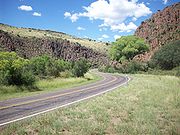
SH 17 continues toward Fort Davis as a two-lane roadway with a 70 mile per hour speed limit. The route follows mostly straight stretches with no sharp turns or steep grades through open ranch land.
. At this point, SH 17 joins the Davis Mountains Scenic Loop.
The road then enters Fort Davis where the route is called State Street. SH 17 intersects State Highway 118 approaching from the east via Musquiz Drive just south of the Jeff Davis County Courthouse. At this junction, SH 17 joins the Texas Historical Commission's
Texas Mountain Trail. SH 118 runs concurrently down State Street through town and past Fort Davis National Historic Site
for a distance of 1.3 miles. The route intersects Lt. Flipper
Dr., the entrance to the historic site. Across from the historic site, the route intersects Blackfoot Dr. known locally as Old Balmorhea Rd. which is the route's former unpaved roadway before the establishment of the state highway system. Just beyond the historic site, the route intersects Canyon Drive. At this point, SH 118, Davis Mountains Scenic Loop, and the Texas Mountain Trail leave the route and continue west along Canyon Dr. toward Davis Mountains State Park
, McDonald Observatory
, and Kent
.
 Blackfoot Dr. merges back with the route as SH 17 leaves town continuing northward through Limpia Canyon in the Davis Mountains
with a maximum speed limit of 55 mph. In Limpia Canyon, the road has many curves, some with recommended speeds as low as 40 mph as indicated by warning signs. There are also several picnic tables in the canyon followed by one large picnic area just before reaching Wild Rose Pass. About 1.8 miles past this pass, the speed limit increases to 70 mph. The route remains a two-lane road, but from this point onward there are places where passing lanes occur.
Continuing northward, the route intersects the eastern terminus of Ranch to Market Road 1832
approaching from Buffalo Trails Boy Scout Ranch. SH 17 then continues through ranch land and leaves the Davis Mountains before leaving the county.
at Toyahvale
. FM 3078 is the former roadway of U.S. Route 290
before it was replaced by Interstate 10
. SH 17 turns east onto the former US 290 roadway and reaches Texas Park Road 30 into Balmorhea State Park
at Toyahvale.
 Continuing into Balmorhea, the route passes fields of alfalfa watered from irrigation ditches including one running parallel with the highway. In Balmorhea, this irrigation channel becomes the centerpiece of a city park along one side of SH 17 here known as Main Street. The route intersects Business Interstate 10-F at North Fort Worth Street. I-10 Bus. Loop F going northward becomes Farm to Market Road 2903 to Toyah
after crossing Interstate 10
. Eastward, I-10 Bus. Loop F overlays the route of SH 17.
After Balmorhea, the route has a speed limit of 55 mph and passes just north of the foothills of the Davis Mountains and through the small community of Brogado before reaching I-10. At I-10 Exit 209, I-10 Bus. Loop F ends, and SH 17 merges with the Interstate for slightly more than 2 miles with a speed limit of 80 mph. SH 17 leaves I-10 at Exit 212 and heads northward with a speed limit of 70 mph toward Saragosa
. At Saragosa, the route intersects Farm to Market Road 1215 which merges with SH 17 and the speed limit lowers to 55 mph. In the center of Saragosa, FM 1215 turns westward at West Main Street and loops back to end at the north service road of I-10 and SH-17 without crossing or intersecting the main Interstate roadway.
Beyond Saragosa, the route begins to parallel the route of the Pecos Valley Southern Railway
which will follow SH 17 the rest of the way into Pecos. The speed limit gradually increases to 65 mph before intersecting Farm to Market Road 2448. The speed limit then increases to 75 mph as the route passes through cotton fields with occasional oil wells. The route then intersects Farm to Market Road 3334 before passing through the small community of Verhalen. The route then intersects Farm to Market Road 869 and later Farm to Market Road 1934.
The route passes alongside the community of Lindsay
as it approaches the outskirts of Pecos. The route then passes Pecos Municipal Airport
. The speed limit gradually lowers to 55 mph and then widens to four lanes before reaching Interstate 20
. In Pecos, the route intersects I-20 at I-20 Exit 39 then continues north as South Bickley Avenue. The route then intersects Farm to Market Road 761 at Stafford Boulevard, then further north SH 17 terminates at West 3rd Street where it intersects Business Interstate 20-B.

 SH 17 was one of the original 26 highways proposed in Texas in 1917. The original route was to be from another proposed route State Highway 12 running along the Rio Grande
to Sanderson
, then through Fort Stockton
and Pecos to the New Mexico
state line. By 1922, the new plan for SH 17 was then from Sanderson to Fort Stockton to Grandfalls
ending at Monahans
with a spur from Grandfalls to Barstow
, and with a separate route, SH 17A, running from Alpine
through Fort Davis
, Balmorhea, and Pecos to New Mexico.
All route descriptions before 1924 were merely proposals. The Texas Highway Department, a precursor of the Texas Department of Transportation
, did not have the authority to assume maintenance of roads from the counties until 1924, nor the authority to plan, survey, or build new roads until 1925. By 1933, SH 17 had been transferred to SH 82, while SH 17A was reclassified as the main route of SH 17 but with a route beginning in Presidio
and reaching Fort Davis by way of Marfa instead of Alpine. By 1936, the stretch from Pecos to New Mexico had been transferred to SH 27. By 1939,the stretch from Presidio to Marfa was transferred to U.S. Highway 67.
Marfa, Texas
Marfa is a town in the high desert of far West Texas in the Southwestern United States. Located between the Davis Mountains and Big Bend National Park, it is also the county seat of Presidio County. The population was 1,981 at the 2010 census....
to Pecos
Pecos, Texas
Pecos is the largest city in and the county seat of Reeves County, Texas, United States. It is situated in the river valley on the west bank of the Pecos River at the eastern edge of the Chihuahuan Desert and the Trans-Pecos region of west Texas and near the southern border of New Mexico...
in west Texas
Texas
Texas is the second largest U.S. state by both area and population, and the largest state by area in the contiguous United States.The name, based on the Caddo word "Tejas" meaning "friends" or "allies", was applied by the Spanish to the Caddo themselves and to the region of their settlement in...
. The road is maintained by the Texas Department of Transportation (TxDOT)
Texas Department of Transportation
The Texas Department of Transportation is a governmental agency in the U.S. state of Texas. Its stated mission is to "work cooperatively to provide safe, effective and efficient movement of people and goods" throughout the state...
.
Route description
State Highway 17 begins at Marfa in Presidio CountyPresidio County, Texas
Presidio County is a county located in the U.S. state of Texas. In 2000, its population was 7,304. Its county seat is Marfa. Presidio County is in the Trans-Pecos region of West Texas and is named for the ancient border settlement of Presidio del Norte.-Geography:Presidio County is triangular in...
, passes through Jeff Davis County
Jeff Davis County, Texas
Jeff Davis County is a county in the U.S. state of Texas. It is named for Jefferson Davis, the president of the Confederate States of America. It is one of the nine counties that comprise the Trans-Pecos region of West Texas. In 2000, its population was 2,207, and 2,258 by 2009...
, and terminates at Pecos in Reeves County
Reeves County, Texas
Reeves County is a county located in the US state of Texas. It is one of the nine counties that comprise the Trans-Pecos region of West Texas. In 2000, its population was 13,137. Its seat is Pecos. Reeves County is named for George R. Reeves, a Texas state legislator and colonel in the...
.
Presidio County
Concurrency (road)
A concurrency, overlap, or coincidence in a road network is an instance of one physical road bearing two or more different highway, motorway, or other route numbers...
with US 90. SH 17 proceeds north along Highland Ave.
After two blocks, SH 17 intersects the beginning of Farm to Market Road 1112
Farm to Market Road 1112
Farm to Market Road 1112 is a farm to market road located entirely within Presidio County.-Route description:The western terminus of FM 1112 is at in Marfa. The route travels east on E. Oak St. before turning north on Golf Course Rd. and ending at the Marfa Municipal Golf Course.-Major...
which proceeds eastward along E. Oak St. which runs parallel to the Union Pacific Railroad
Union Pacific Railroad
The Union Pacific Railroad , headquartered in Omaha, Nebraska, is the largest railroad network in the United States. James R. Young is president, CEO and Chairman....
.
SH 17 proceeds north an additional two blocks, then turns east along E. Lincoln St. directly in front of the Presidio County Courthouse. One block later, the route turns north and leaves Marfa along N. Dean St. North of town, the route passes Marfa Municipal Airport.
SH 17 continues toward Fort Davis as a two-lane roadway with a 70 mile per hour speed limit. The route follows mostly straight stretches with no sharp turns or steep grades through open ranch land.
Jeff Davis County
Soon after entering Jeff Davis County, SH 17 continues through a gentle pass across the Puertacitas Mountains. The route then passes along mostly straight stretches through ranch land. Approximately two miles south of Fort Davis, the route intersects the western terminus of State Highway 166Texas State Highway 166
State Highway 166 or SH 166 runs for from SH 118 near Nunn Hill in northern Jeff Davis County, Texas passing around a major portion of the Davis Mountains before ending at SH 17 about two miles south of Fort Davis...
. At this point, SH 17 joins the Davis Mountains Scenic Loop.
The road then enters Fort Davis where the route is called State Street. SH 17 intersects State Highway 118 approaching from the east via Musquiz Drive just south of the Jeff Davis County Courthouse. At this junction, SH 17 joins the Texas Historical Commission's
Texas Historical Commission
The Texas Historical Commission is an agency dedicated to historic preservation within the state of Texas. It administers the National Register of Historic Places for sites in Texas....
Texas Mountain Trail. SH 118 runs concurrently down State Street through town and past Fort Davis National Historic Site
Fort Davis National Historic Site
Fort Davis National Historic Site is a United States National Historic Site located in unincorporated Jeff Davis County, Texas. Located within the Davis Mountains of West Texas, the historic site was established in 1961 to protect one of the best remaining examples of a United States Army fort in...
for a distance of 1.3 miles. The route intersects Lt. Flipper
Henry Ossian Flipper
Henry Ossian Flipper was an American soldier and though born into slavery in the American South, was the first African American to graduate from the United States Military Academy at West Point in 1877 at the age of 21 and earn a commission as a 2nd Lieutenant in the US Army.Following Flipper's...
Dr., the entrance to the historic site. Across from the historic site, the route intersects Blackfoot Dr. known locally as Old Balmorhea Rd. which is the route's former unpaved roadway before the establishment of the state highway system. Just beyond the historic site, the route intersects Canyon Drive. At this point, SH 118, Davis Mountains Scenic Loop, and the Texas Mountain Trail leave the route and continue west along Canyon Dr. toward Davis Mountains State Park
Davis Mountains State Park
Davis Mountains State Park is a state park located in the Davis Mountains in Jeff Davis County, Texas. The closest town is Fort Davis, Texas. The park elevation is between 5000 and 6000 feet above sea level. The original portion of the park was deeded to Texas Parks and Wildlife Department by a...
, McDonald Observatory
McDonald Observatory
The McDonald Observatory is an astronomical observatory located near the unincorporated community of Fort Davis in Jeff Davis County, Texas, United States. The facility is located on Mount Fowlkes and Mount Locke in the Davis Mountains of West Texas...
, and Kent
Kent, Texas
Kent is an unincorporated village in Culberson County, in West Texas, United States. It lies just north of Interstate 10 at Exit 176, ten miles west of the beginning of Interstate 20 and four miles west of the eastern Culberson County boundary. It is sandwiched between the railroad, immediately...
.
Davis Mountains
The Davis Mountains are a range of mountains in West Texas, located near Fort Davis, after which they are named. They are a popular site for camping and hiking and the region includes Fort Davis National Historic Site and Davis Mountains State Park...
with a maximum speed limit of 55 mph. In Limpia Canyon, the road has many curves, some with recommended speeds as low as 40 mph as indicated by warning signs. There are also several picnic tables in the canyon followed by one large picnic area just before reaching Wild Rose Pass. About 1.8 miles past this pass, the speed limit increases to 70 mph. The route remains a two-lane road, but from this point onward there are places where passing lanes occur.
Continuing northward, the route intersects the eastern terminus of Ranch to Market Road 1832
Ranch to Market Road 1832
Ranch to Market Road 1832, Ranch Road 1832, or RM 1832 is a route maintained by the Texas Department of Transportation that connects the Boy Scouts of America's Buffalo Trails Scout Ranch to State Highway 17 about north of Fort Davis. The road is part of the state's Farm and Ranch to Market Road...
approaching from Buffalo Trails Boy Scout Ranch. SH 17 then continues through ranch land and leaves the Davis Mountains before leaving the county.
Reeves County
The route continues northward and intersects Farm to Market Road 3078Farm to Market Road 3078
Farm to Market Road 3078, Farm Road 3078, or FM 3078 is a road maintained by the Texas Department of Transportation that connects Interstate 10 to State Highway 17 in Toyahvale. The route is in Jeff Davis County and Reeves County and connects Toyahvale to points farther west along I-10 including...
at Toyahvale
Toyahvale, Texas
Toyahvale is an unincorporated community in southern Reeves County, Texas, United States. It lies along State Highway 17 and FM 3078 south of the city of Pecos, the county seat of Reeves County. Despite its similar name, Toyahvale is distinct from the town of Toyah, which lies 25 miles to...
. FM 3078 is the former roadway of U.S. Route 290
U.S. Route 290
U.S. Highway 290 is an east–west U.S. Highway located entirely within the State of Texas. Its current western terminus is at Interstate 10 milepost 477 , southeast of Junction, and its eastern terminus is at Interstate 610 on the northwest side of Houston.-Route Description:West of Austin, U.S...
before it was replaced by Interstate 10
Interstate 10 in Texas
Interstate 10 is the major east–west Interstate Highway in the Southern United States. In the U.S. state of Texas, it runs east from El Paso, near the border with New Mexico, through San Antonio and Houston to the border with Louisiana in Orange, Texas....
. SH 17 turns east onto the former US 290 roadway and reaches Texas Park Road 30 into Balmorhea State Park
Balmorhea State Park
Balmorhea State Park is a state park located on the San Solomon Springs in Reeves County, Texas, opened in 1968. The closest major town is Balmorhea, Texas. The park is open year round.-Features:...
at Toyahvale.
Toyah, Texas
Toyah is a town in Reeves County, Texas, United States. The population was 100 at the 2000 census.-Geography:Toyah is located at .According to the United States Census Bureau, the town has a total area of , all of it land....
after crossing Interstate 10
Interstate 10 in Texas
Interstate 10 is the major east–west Interstate Highway in the Southern United States. In the U.S. state of Texas, it runs east from El Paso, near the border with New Mexico, through San Antonio and Houston to the border with Louisiana in Orange, Texas....
. Eastward, I-10 Bus. Loop F overlays the route of SH 17.
After Balmorhea, the route has a speed limit of 55 mph and passes just north of the foothills of the Davis Mountains and through the small community of Brogado before reaching I-10. At I-10 Exit 209, I-10 Bus. Loop F ends, and SH 17 merges with the Interstate for slightly more than 2 miles with a speed limit of 80 mph. SH 17 leaves I-10 at Exit 212 and heads northward with a speed limit of 70 mph toward Saragosa
Saragosa, Texas
Saragosa is an unincorporated community in Reeves County, Texas, United States. According to the Handbook of Texas, the community had an estimated population of 185 in 2000....
. At Saragosa, the route intersects Farm to Market Road 1215 which merges with SH 17 and the speed limit lowers to 55 mph. In the center of Saragosa, FM 1215 turns westward at West Main Street and loops back to end at the north service road of I-10 and SH-17 without crossing or intersecting the main Interstate roadway.
Beyond Saragosa, the route begins to parallel the route of the Pecos Valley Southern Railway
Pecos Valley Southern Railway
The Pecos Valley Southern Railway is a short-line railroad headquartered in Pecos, Texas, United States.PVS operates a 29.3 mile line from Saragosa to an interchange with Union Pacific at Pecos...
which will follow SH 17 the rest of the way into Pecos. The speed limit gradually increases to 65 mph before intersecting Farm to Market Road 2448. The speed limit then increases to 75 mph as the route passes through cotton fields with occasional oil wells. The route then intersects Farm to Market Road 3334 before passing through the small community of Verhalen. The route then intersects Farm to Market Road 869 and later Farm to Market Road 1934.
The route passes alongside the community of Lindsay
Lindsay, Reeves County, Texas
Lindsay is a census-designated place in Reeves County, Texas, United States. The population was 394 at the 2000 census.-Geography:Lindsay is located at ....
as it approaches the outskirts of Pecos. The route then passes Pecos Municipal Airport
Pecos Municipal Airport
Pecos Municipal Airport is a city-owned, public-use airport located two nautical miles southwest of the central business district of Pecos, a city in Reeves County, Texas, United States...
. The speed limit gradually lowers to 55 mph and then widens to four lanes before reaching Interstate 20
Interstate 20 in Texas
Interstate 20 in Texas is a major east–west Interstate Highway in the Southern United States, running east from a junction with Interstate 10 east of Kent, Texas, through the Dallas-Fort Worth Metroplex to the border with Louisiana near Waskom, Texas...
. In Pecos, the route intersects I-20 at I-20 Exit 39 then continues north as South Bickley Avenue. The route then intersects Farm to Market Road 761 at Stafford Boulevard, then further north SH 17 terminates at West 3rd Street where it intersects Business Interstate 20-B.
History
Rio Grande
The Rio Grande is a river that flows from southwestern Colorado in the United States to the Gulf of Mexico. Along the way it forms part of the Mexico – United States border. Its length varies as its course changes...
to Sanderson
Sanderson, Texas
Sanderson is a census-designated place in and the county seat of Terrell County, Texas, United States. The population was 861 at the 2000 census. Sanderson was created in 1882 as a part of neighboring Pecos County...
, then through Fort Stockton
Fort Stockton, Texas
Fort Stockton is a city in Pecos County, Texas, United States. The population was 7,846 at the 2000 census. It is the county seat of Pecos County.-Geography:Fort Stockton is located at ....
and Pecos to the New Mexico
New Mexico
New Mexico is a state located in the southwest and western regions of the United States. New Mexico is also usually considered one of the Mountain States. With a population density of 16 per square mile, New Mexico is the sixth-most sparsely inhabited U.S...
state line. By 1922, the new plan for SH 17 was then from Sanderson to Fort Stockton to Grandfalls
Grandfalls, Texas
Grandfalls is a town in Ward County, Texas, United States. It was named for its location near the "grand falls" of the Pecos River, located roughly to the west. Early settlers were attracted to the Grandfalls area in the late 1880s by the steady supply of water flowing in the Pecos River...
ending at Monahans
Monahans, Texas
Monahans is a city in and the county seat of Ward County, Texas, United States. A very small portion of the city extends into Winkler County. The population was 6,821 at the 2000 census.-History:...
with a spur from Grandfalls to Barstow
Barstow, Texas
Barstow is a city in Ward County, Texas, United States. The population was 406 at the 2000 census.-Geography:Barstow is located at ....
, and with a separate route, SH 17A, running from Alpine
Alpine, Texas
Alpine is a city in and the county seat of Brewster County, Texas, United States. The population was 5,786 people at the 2000 census, and had increased to 5,905 by 2010.-History:...
through Fort Davis
Fort Davis, Texas
Fort Davis is a census-designated place in Jeff Davis County, Texas, United States. The population was 1,050 at the 2000 census and 1,041 according to a 2007 estimate. It is the county seat of Jeff Davis County...
, Balmorhea, and Pecos to New Mexico.
All route descriptions before 1924 were merely proposals. The Texas Highway Department, a precursor of the Texas Department of Transportation
Texas Department of Transportation
The Texas Department of Transportation is a governmental agency in the U.S. state of Texas. Its stated mission is to "work cooperatively to provide safe, effective and efficient movement of people and goods" throughout the state...
, did not have the authority to assume maintenance of roads from the counties until 1924, nor the authority to plan, survey, or build new roads until 1925. By 1933, SH 17 had been transferred to SH 82, while SH 17A was reclassified as the main route of SH 17 but with a route beginning in Presidio
Presidio, Texas
Presidio is a city in Presidio County, Texas, United States. It stands on the Rio Grande , on the opposite side of the U.S.-Mexico border from Ojinaga, Chihuahua. The population was 4,167 at the 2000 census....
and reaching Fort Davis by way of Marfa instead of Alpine. By 1936, the stretch from Pecos to New Mexico had been transferred to SH 27. By 1939,the stretch from Presidio to Marfa was transferred to U.S. Highway 67.