
Interstate 20 in Texas
Encyclopedia
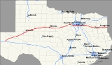
Interstate 20 in Texas
(abbreviated I-20 or IH-20) is a major east–west Interstate Highway in the Southern United States
, running east from a junction with Interstate 10
east of Kent, Texas
, through the Dallas-Fort Worth Metroplex to the border with Louisiana
near Waskom, Texas
. The original distance of Interstate 20 was 647 miles (1,041.2 km) from I-10 to the Louisiana border, reduced to the current distance of 636 miles (1,023.5 km) with the rerouting of I-20 in the 1980s and 1990s.
. Initial construction began from east to west and as bypass loops around larger cities. By 1967, the highway was complete from the Louisiana border to the western side of Fort Worth on a route to the south of US 80, with slower construction in the lesser populated areas of West Texas concurrent with US 80. In 1971, I-20 was rerouted across the southern side of the Dallas/Fort Worth Metroplex, with the old section through downtown Dallas and Fort Worth being redesignated as Interstate 30. In 1991, the entire concurrent designation of US 80 was removed from the I-10 interchange to Dallas.
in a desolate region of West Texas about 6 miles (10 km) east of the town of Kent
. I-20 leaves the interchange with I-10 with a speed limit of 80 until Milemarker 89. The speed limit may go up to 85 miles per hour this very same stretch. Interstate 20 also generally heads to the east-northeast passing by the cities of Odessa
and Midland
while transitioning from the West Texas desert to the prairie. I-20 runs concurrently with the La Entrada al Pacífico
corridor from its junction with US 385 in Odessa to its junction with FM 1788
near Midland International Airport
. Near Sweetwater
, I-20 begins to head due east as it heads towards the city of Abilene
. In Abilene, I-20 curves towards the north and transverses the northern part of the city while also forming the northern arc of the loop around the city. I-20 continues heading east from Abilene until the town of Eastland
when I-20 takes a more northeasterly route towards Weatherford
while transitioning from the West Texas prairie to the central plains of North Texas the terrain grows hilly. In Weatherford, I-20 again heads back towards the east as it heads towards the Dallas-Fort Worth Metroplex.
 I-20 interchanges with I-30 west of Fort Worth with I-30 heading east and I-20 to the southeast. I-20 heads back towards the east when it interchanges with Interstate 820. I-20 forms the southern arc of the complete loop around the city of Fort Worth
, and serves as the southernmost west–east freeway in the Dallas-Fort Worth Metroplex. Interchanging with I-35W
south of downtown, I-20 heads east towards Dallas passing through Arlington
, where it is also known as the Ronald Reagan
Memorial Highway. From Arlington, I-20 passes into Dallas County at Grand Prairie
and heads east in to Dallas, interchanging with I-35E
south of downtown and I-45 shortly after. I-20 intersects with I-635
(where it completes a three-quarter loop around the city) on Dallas' southeast side before heading east towards East Texas. The interstate varies from 4 to 10 lanes from its I-30 junction near Weatherford to its US-80 junction near Terrell.
going through Kilgore in the pine belt region of East Texas. I-20 leaves the state of Texas near Waskom
and just west of Shreveport, Louisiana
.
. Interstate 20 has fifteen business loops in the state, all located in western Texas. Along I-20, TxDOT identifies each business route as Business Interstate 20 followed by an alphabetic suffix. Along Texas Interstates, the alphabetic suffixes on business route names ascend eastward and northward. There are gaps in the alphabetic values to allow for future system expansion. The alphabetic naming suffixes are included as small letters on the bottom of route shields.
I-20 business routes in Texas generally follow the path of the former US 80 through the central portions of towns now bypassed by the Interstate route.
Texas
Texas is the second largest U.S. state by both area and population, and the largest state by area in the contiguous United States.The name, based on the Caddo word "Tejas" meaning "friends" or "allies", was applied by the Spanish to the Caddo themselves and to the region of their settlement in...
(abbreviated I-20 or IH-20) is a major east–west Interstate Highway in the Southern United States
Southern United States
The Southern United States—commonly referred to as the American South, Dixie, or simply the South—constitutes a large distinctive area in the southeastern and south-central United States...
, running east from a junction with Interstate 10
Interstate 10 in Texas
Interstate 10 is the major east–west Interstate Highway in the Southern United States. In the U.S. state of Texas, it runs east from El Paso, near the border with New Mexico, through San Antonio and Houston to the border with Louisiana in Orange, Texas....
east of Kent, Texas
Kent, Texas
Kent is an unincorporated village in Culberson County, in West Texas, United States. It lies just north of Interstate 10 at Exit 176, ten miles west of the beginning of Interstate 20 and four miles west of the eastern Culberson County boundary. It is sandwiched between the railroad, immediately...
, through the Dallas-Fort Worth Metroplex to the border with Louisiana
Louisiana
Louisiana is a state located in the southern region of the United States of America. Its capital is Baton Rouge and largest city is New Orleans. Louisiana is the only state in the U.S. with political subdivisions termed parishes, which are local governments equivalent to counties...
near Waskom, Texas
Waskom, Texas
Waskom is a city in Harrison County, Texas, United States. It lies about east of the county seat, Marshall, on U.S. Route 80. To the east is Shreveport, Louisiana...
. The original distance of Interstate 20 was 647 miles (1,041.2 km) from I-10 to the Louisiana border, reduced to the current distance of 636 miles (1,023.5 km) with the rerouting of I-20 in the 1980s and 1990s.
History
Interstate 20 in Texas was designated in 1959, and was to replace or run parallel to U.S. Route 80U.S. Route 80
U.S. Route 80 is an east–west United States highway, much of which was once part of the early auto trail known as the Dixie Overland Highway. As the "0" in the route number indicates, it was originally a cross-country route, from the Atlantic to the Pacific...
. Initial construction began from east to west and as bypass loops around larger cities. By 1967, the highway was complete from the Louisiana border to the western side of Fort Worth on a route to the south of US 80, with slower construction in the lesser populated areas of West Texas concurrent with US 80. In 1971, I-20 was rerouted across the southern side of the Dallas/Fort Worth Metroplex, with the old section through downtown Dallas and Fort Worth being redesignated as Interstate 30. In 1991, the entire concurrent designation of US 80 was removed from the I-10 interchange to Dallas.
West Texas
I-20 begins at a junction with I-10Interstate 10 in Texas
Interstate 10 is the major east–west Interstate Highway in the Southern United States. In the U.S. state of Texas, it runs east from El Paso, near the border with New Mexico, through San Antonio and Houston to the border with Louisiana in Orange, Texas....
in a desolate region of West Texas about 6 miles (10 km) east of the town of Kent
Kent, Texas
Kent is an unincorporated village in Culberson County, in West Texas, United States. It lies just north of Interstate 10 at Exit 176, ten miles west of the beginning of Interstate 20 and four miles west of the eastern Culberson County boundary. It is sandwiched between the railroad, immediately...
. I-20 leaves the interchange with I-10 with a speed limit of 80 until Milemarker 89. The speed limit may go up to 85 miles per hour this very same stretch. Interstate 20 also generally heads to the east-northeast passing by the cities of Odessa
Odessa, Texas
Odessa is a city in and the county seat of Ector County, Texas, United States. It is located primarily in Ector County, although a small portion of the city extends into Midland County. Odessa's population was 99,940 at the 2010 census. It is the principal city of the Odessa, Texas Metropolitan...
and Midland
Midland, Texas
Midland is a city in and the county seat of Midland County, Texas, United States, on the Southern Plains of the state's western area. A small portion of the city extends into Martin County. As of 2010, the population of Midland was 111,147. It is the principal city of the Midland, Texas...
while transitioning from the West Texas desert to the prairie. I-20 runs concurrently with the La Entrada al Pacífico
La Entrada al Pacífico
The La Entrada al Pacífico trade corridor was designated as "Trade Corridor 56" by the Intermodal Surface Transportation Efficiency Act. The corridor is an international project between Mexico and the United States as a route from the Pacific Ocean port of Topolobampo in the Mexican state of...
corridor from its junction with US 385 in Odessa to its junction with FM 1788
Farm to Market Road 1788
Farm to Market Road 1788, FM 1788, is a Farm-to-market road in West Texas. It runs from FM 1787 in Upton County between Midland and Odessa near the Midland International Airport, to the SH 115. FM 1788 carries the La Entrada al Pacifico Corridor from its intersection with Interstate 20 to SH 349....
near Midland International Airport
Midland International Airport
-Top Destinations:-See also:* Texas World War II Army Airfields-References:* Shaw, Frederick J. , Locating Air Force Base Sites History’s Legacy, Air Force History and Museums Program, United States Air Force, Washington DC, 2004....
. Near Sweetwater
Sweetwater, Texas
Sweetwater is the county seat of Nolan County, Texas, United States. The population was 11,415 at the 2000 census.-History:Sweetwater received a U.S. post office in 1879. The Texas and Pacific Railway started service in 1881, with the first train arriving on March 12 of that year, beginning...
, I-20 begins to head due east as it heads towards the city of Abilene
Abilene, Texas
Abilene is a city in Taylor and Jones counties in west central Texas. The population was 117,063 at the 2010 census. It is the principal city of the Abilene Metropolitan Statistical Area, which had a 2006 estimated population of 158,063. It is the county seat of Taylor County...
. In Abilene, I-20 curves towards the north and transverses the northern part of the city while also forming the northern arc of the loop around the city. I-20 continues heading east from Abilene until the town of Eastland
Eastland, Texas
Eastland is a city in Eastland County, Texas, United States. The population was 3,769 at the 2000 census. It is the county seat of Eastland County.During the 1920s, Eastland, like nearby Cisco, Ranger, and Desdemona, were petroleum boomtowns....
when I-20 takes a more northeasterly route towards Weatherford
Weatherford, Texas
Weatherford is a city in Parker County, Texas, United States, and a western suburb of Fort Worth. The population was 19,000 at the 2000 census. It is the county seat of Parker County and is part of the Dallas-Fort Worth Metroplex.-Geography:...
while transitioning from the West Texas prairie to the central plains of North Texas the terrain grows hilly. In Weatherford, I-20 again heads back towards the east as it heads towards the Dallas-Fort Worth Metroplex.
Dallas – Fort Worth area
Fort Worth, Texas
Fort Worth is the 16th-largest city in the United States of America and the fifth-largest city in the state of Texas. Located in North Central Texas, just southeast of the Texas Panhandle, the city is a cultural gateway into the American West and covers nearly in Tarrant, Parker, Denton, and...
, and serves as the southernmost west–east freeway in the Dallas-Fort Worth Metroplex. Interchanging with I-35W
Interstate 35W (Texas)
Interstate 35W , an Interstate Highway, is the western half of Interstate 35 where it splits to serve different cities in Texas. I-35 splits into two branch routes, I-35W and I-35E at Hillsboro. I-35W runs north for , carrying its own separate sequence of exit numbers. It runs through Fort Worth...
south of downtown, I-20 heads east towards Dallas passing through Arlington
Arlington, Texas
Arlington is a city in Tarrant County, Texas within the Dallas–Fort Worth metropolitan area. According to the 2010 census results, the city had a population of 365,438, making it the third largest municipality in the Metroplex...
, where it is also known as the Ronald Reagan
Ronald Reagan
Ronald Wilson Reagan was the 40th President of the United States , the 33rd Governor of California and, prior to that, a radio, film and television actor....
Memorial Highway. From Arlington, I-20 passes into Dallas County at Grand Prairie
Grand Prairie, Texas
Grand Prairie is a city in Dallas, Ellis, and Tarrant counties in the U.S. state of Texas and is a part of the Mid-Cities region in the Dallas–Fort Worth metroplex. Grand Prairie is a suburb of both Dallas and Fort Worth and had a population of 175,396 at the 2010 census.- History :The city of...
and heads east in to Dallas, interchanging with I-35E
Interstate 35E (Texas)
Interstate 35E , an Interstate Highway, is the eastern half of Interstate 35 where it splits to serve different cities in Texas. I-35 splits into two branch routes, I-35W and I-35E at Hillsboro. I-35E runs north for , maintaining I-35's sequence of exit numbers. It runs through Dallas before...
south of downtown and I-45 shortly after. I-20 intersects with I-635
Interstate 635 (Texas)
Interstate 635 or the Lyndon B. Johnson Freeway is a partial loop around Dallas, Texas between Interstate 20 in Balch Springs, Texas and State Highway 121 at the north entrance of the Dallas-Fort Worth International Airport in Grapevine, Texas. The route is long...
(where it completes a three-quarter loop around the city) on Dallas' southeast side before heading east towards East Texas. The interstate varies from 4 to 10 lanes from its I-30 junction near Weatherford to its US-80 junction near Terrell.
East Texas
I-20 leaves the Dallas-Fort Worth Metroplex and heads generally to the east-southeast through East Texas. I-20 begins heading to the east as it passes to the north of the city of TylerTyler, Texas
Tyler is a city in and the county seat of Smith County, Texas, in the United States. It takes its name from President John Tyler . The city had a population of 109,000 in 2010, according to the United States Census Bureau...
going through Kilgore in the pine belt region of East Texas. I-20 leaves the state of Texas near Waskom
Waskom, Texas
Waskom is a city in Harrison County, Texas, United States. It lies about east of the county seat, Marshall, on U.S. Route 80. To the east is Shreveport, Louisiana...
and just west of Shreveport, Louisiana
Shreveport, Louisiana
Shreveport is the third largest city in Louisiana. It is the principal city of the fourth largest metropolitan area in the state of Louisiana and is the 109th-largest city in the United States....
.
Auxiliary route
Interstate 20 has one auxiliary route in Texas.- Interstate 820 is a 35.2 miles (56.6 km) loop around the city of Fort Worth. It once completely circumnavigated the city prior to I-20 absorbing the southern section as part of its relocation to the south and I-30 being extended westward over the old alignment of I-20 through the center of town.
Business routes
All of the business loops within Texas are maintained by the Texas Department of Transportation (TxDOT)Texas Department of Transportation
The Texas Department of Transportation is a governmental agency in the U.S. state of Texas. Its stated mission is to "work cooperatively to provide safe, effective and efficient movement of people and goods" throughout the state...
. Interstate 20 has fifteen business loops in the state, all located in western Texas. Along I-20, TxDOT identifies each business route as Business Interstate 20 followed by an alphabetic suffix. Along Texas Interstates, the alphabetic suffixes on business route names ascend eastward and northward. There are gaps in the alphabetic values to allow for future system expansion. The alphabetic naming suffixes are included as small letters on the bottom of route shields.
I-20 business routes in Texas generally follow the path of the former US 80 through the central portions of towns now bypassed by the Interstate route.
Exit list
| County | Location | # Exit number An exit number is a number assigned to a road junction, usually an exit from a freeway. It is usually marked on the same sign as the destinations of the exit, as well as a sign in the gore.... |
Destinations | Notes |
|---|---|---|---|---|
| Reeves Reeves County, Texas Reeves County is a county located in the US state of Texas. It is one of the nine counties that comprise the Trans-Pecos region of West Texas. In 2000, its population was 13,137. Its seat is Pecos. Reeves County is named for George R. Reeves, a Texas state legislator and colonel in the... |
Westbound exit and eastbound entrance | |||
| 186 | Westbound exit and eastbound entrance, exit no. corresponds to I-10 west | |||
| 3 | Stocks Road | |||
| 7 | Johnson Road | |||
| 13 | McAlpine Road | |||
| Toyah Toyah, Texas Toyah is a town in Reeves County, Texas, United States. The population was 100 at the 2000 census.-Geography:Toyah is located at .According to the United States Census Bureau, the town has a total area of , all of it land.... |
22 | |||
| 29 | Shaw Road | |||
| 33 | ||||
| 37 | ||||
| Pecos Pecos, Texas Pecos is the largest city in and the county seat of Reeves County, Texas, United States. It is situated in the river valley on the west bank of the Pecos River at the eastern edge of the Chihuahuan Desert and the Trans-Pecos region of west Texas and near the southern border of New Mexico... |
39 | |||
| 40 | Country Club Drive | |||
| 42 | , Carlsbad Carlsbad, New Mexico Carlsbad is a city in and the county seat of Eddy County, New Mexico, in the United States. As of the 2010 census, the city population was 26,138. Carlsbad is the center of the designated micropolitan area of Carlsbad-Artesia, which has a total population of 55,435... |
|||
| 44 | Collie Road | |||
| Ward | ||||
| 49 | ||||
| 52 | Westbound exit and eastbound entrance | |||
| 58 | Frontage Road | |||
| Pyote Pyote, Texas Pyote is a town in Ward County, Texas, United States. The population was 131 at the 2000 census.-History:Pyote began as a small town. Its fortunes rose with oil, but its population decreased when the railroad was built away from the town. At one time Pyote had 3,500 residents... |
66 | |||
| 70 | ||||
| Wickett Wickett, Texas Wickett is a town in Ward County, Texas, United States. The population was 455 at the 2000 census.-Geography:Wickett is located at .... |
73 | |||
| 76 | ||||
| Thorntonville Thorntonville, Texas Thorntonville is a town in Ward County, Texas, United States. The population was 442 at the 2000 census.-Geography:Thorntonville is located at .... |
79 | |||
| Monahans Monahans, Texas Monahans is a city in and the county seat of Ward County, Texas, United States. A very small portion of the city extends into Winkler County. The population was 6,821 at the 2000 census.-History:... |
80 | |||
| 83 | ||||
| 86 | – Monahans Sandhills State Park Monahans Sandhills State Park The Monahans Sandhills State Park is a state park located in Ward County and Winkler County, Texas. The closest major town is Monahans, Texas, and the closest limited-access highway ingress is Exit 86 on Interstate 20.-Features:... |
|||
| Ector | 93 | |||
| 101 | ||||
| 104 | ||||
| 108 | Moss Avenue – Meteor Crater Odessa Meteor Crater The Odessa Meteor Crater is a meteorite crater in the southwestern part of Ector County, southwest of the city of Odessa, Texas, United States. It is located approximately 3 miles south of I-20 at FM 1936 south... |
|||
| 112 | ||||
| 113 | ||||
| Odessa Odessa, Texas Odessa is a city in and the county seat of Ector County, Texas, United States. It is located primarily in Ector County, although a small portion of the city extends into Midland County. Odessa's population was 99,940 at the 2010 census. It is the principal city of the Odessa, Texas Metropolitan... |
115 | |||
| 116 | ||||
| 118 | ||||
| 120 | JBS Parkway | |||
| 121 | ||||
| Midland | 126 | – Midland International Airport Midland International Airport -Top Destinations:-See also:* Texas World War II Army Airfields-References:* Shaw, Frederick J. , Locating Air Force Base Sites History’s Legacy, Air Force History and Museums Program, United States Air Force, Washington DC, 2004.... |
||
| Midland Midland, Texas Midland is a city in and the county seat of Midland County, Texas, United States, on the Southern Plains of the state's western area. A small portion of the city extends into Martin County. As of 2010, the population of Midland was 111,147. It is the principal city of the Midland, Texas... |
131 | West end of SH 158 overlap | ||
| 134 | Midkiff Road | |||
| 136 | ||||
| 137 | Old Lamesa Road | |||
| 138 | East end of SH 158 overlap | |||
| 140 | – Greenwood Greenwood, Midland County, Texas Greenwood is an unincorporated community in Midland County, Texas, United States. It is a small suburb of Midland and is part of the Midland Metropolitan Statistical Area.The Greenwood Independent School District serves area students.... |
Eastbound exit and entrance | ||
| 143 | Frontage Road | Eastbound exit only | ||
| 144 | ||||
| Martin | 151 | Westbound exit and entrance | ||
| 154 | ||||
| Stanton Stanton, Texas Stanton is a city in and the county seat of Martin County, Texas, United States. The population was 2,556 at the 2000 census.-Geography:Stanton is located at .... |
156 | |||
| 158 | ||||
| Howard | 165 | |||
| 169 | ||||
| 171 | Moore Field Road | |||
| 172 | Cauble Road | |||
| Big Spring Big Spring, Texas Big Spring is a city in and the county seat of Howard County, Texas, United States, at the crossroads of U.S. Highway 87 and Interstate 20. With a population of 25,233 at the 2000 census, it is the largest city between Midland to the west, Abilene to the east, Lubbock to the north, and San Angelo... |
174 | |||
| 176 | ||||
| 177 | ||||
| 178 | ||||
| 179 | ||||
| 181A | ||||
| 181B | Refinery Road | |||
| 182 | Midway Road | |||
| 184 | Moss Lake Road – Sand Springs | |||
| 186 | Salem Road – Sand Springs | |||
| Coahoma Coahoma, Texas Coahoma is a town in Howard County, Texas, United States. The population was 932 at the 2000 census.-Geography:Coahoma is located at .According to the United States Census Bureau, the town has a total area of , all of it land.... |
188 | |||
| 189 | McGregor Road | |||
| 190 | Snyder Field Road | |||
| 192 | ||||
| 194A | East Howard Field Road | |||
| 194B | Frontage Road | Westbound exit and entrance | ||
| 195 | Frontage Road | Eastbound exit only | ||
| Mitchell | 199 | Iatan Road | ||
| 200 | Conaway Road | |||
| 206 | ||||
| Westbrook Westbrook, Texas Westbrook is a city in Mitchell County, Texas, United States. The population was 203 at the 2000 census.-Geography:Westbrook is located at .... |
207 | |||
| 209 | Dorn Road | |||
| 210 | ||||
| 212 | ||||
| 213 | ||||
| Colorado City Colorado City, Texas Colorado City is a city in and the county seat of Mitchell County, Texas, United States. The population was 4,281 at the 2000 census.... |
215 | |||
| 216 | West end of SH 208 overlap | |||
| 217 | East end of SH 208 overlap | |||
| 219A | Country Club Road | Signed as exit 219 eastbound | ||
| 219B | Eastbound exit is via exit 219 | |||
| 220 | ||||
| 221 | Lasky Road | |||
| 223 | Lucas Road | |||
| 224 | ||||
| Loraine Loraine, Texas Loraine is a town in Mitchell County, Texas, United States. The population was 656 at the 2000 census.George H. Mahon , a former county attorney, district attorney, and U.S. representative from the Lubbock-based congressional district is interred at Loraine City Cemetery... |
225 | |||
| 226A | Eastbound exit is via exit 225 | |||
| 226B | ||||
| 227 | Narrell Road | |||
| Nolan | 230 | |||
| 235 | ||||
| Roscoe Roscoe, Texas Roscoe is a town in Nolan County, Texas, United States. The population was 1,378 at the 2000 census, but has decreased to only 900.-Geography:Roscoe is located at .... |
236 | |||
| 237 | Cemetery Road | |||
| 238A | West end of US 84 overlap; no eastbound exit | |||
| 238B | Blackland Road | |||
| 238C | Frontage Road | Eastbound exit and entrance | ||
| 239 | May Road | No access across I-20 | ||
| 240 | ||||
| Sweetwater Sweetwater, Texas Sweetwater is the county seat of Nolan County, Texas, United States. The population was 11,415 at the 2000 census.-History:Sweetwater received a U.S. post office in 1879. The Texas and Pacific Railway started service in 1881, with the first train arriving on March 12 of that year, beginning... |
241 | |||
| 242 | Hopkins Road | |||
| 243 | Hillsdale Road, Robert Lee Street | |||
| 244 | West end of SH 70 overlap | |||
| 245 | Arizona Avenue | Westbound exit only | ||
| 246 | Alabama Avenue | |||
| Sweetwater | 247 | East end of SH 70 overlap | ||
| 249 | ||||
| 251 | Eskota Road | |||
| 255 | Adrian Road | |||
| 256 | Stink Creek Road | |||
| 258 | White Flat Road | |||
| 259 | Sylvester Road | |||
| Taylor Taylor County, Texas As of the census of 2000, there were 126,555 people, 47,274 households, and 32,524 families residing in the county. The population density was 138 people per square mile . There were 52,056 housing units at an average density of 57 per square mile... |
261 | |||
| Trent Trent, Texas Trent is a town in Taylor County, Texas, United States. The population was 318 at the 2000 census. It is part of the Abilene, Texas Metropolitan Statistical Area.-Geography:Trent is located at .... |
262 | |||
| 263 | ||||
| 264 | Noodle Dome Road | |||
| 266 | Derstine Road | |||
| 267 | ||||
| Merkel Merkel, Texas Merkel is a town in Taylor County, Texas, United States. The population was 2,637 at the 2000 census. It is part of the Abilene, Texas Metropolitan Statistical Area.-Geography:Merkel is located 17 miles west of Abilene near the Interstate Highway 20.... |
269 | |||
| 270 | ||||
| 272 | Wimberly Road | |||
| 274 | Wells Lane | |||
| Tye Tye, Texas Tye is a city in Taylor County, Texas, United States. The population was 1,158 at the 2000 census. It is part of the Abilene, Texas Metropolitan Statistical Area.-Geography:Tye is located at .... |
277 | |||
| 278 | ||||
| Abilene Abilene, Texas Abilene is a city in Taylor and Jones counties in west central Texas. The population was 117,063 at the 2010 census. It is the principal city of the Abilene Metropolitan Statistical Area, which had a 2006 estimated population of 158,063. It is the county seat of Taylor County... |
279 | East end of US 84 overlap; no westbound exit | ||
| 280 | Fulwiler Road | |||
| 280- 282 | Eastbound exit is via exit 280; westbound exit is via exit 282 | |||
| 282 | Shirley Road | |||
| 283 | Signed as exits 283A (south) and 283B (north) | |||
| 285 | Old Anson Road – Impact Impact, Texas Impact is a village in Taylor County, Texas, United States. The population was 39 at the 2000 census. It is part of the Abilene, Texas Metropolitan Statistical Area.-Geography:Impact is located at .... |
|||
| 286A | Signed as exits 286A (south) and 286B (north) eastbound | |||
| 286C | ||||
| 288 | ||||
| 290 | ||||
| 292A | ||||
| 292B | Elmdale Road | |||
| Callahan Callahan County, Texas *Baird*Belle Plain*Callahan City*Clyde*Cottonwood*Cross Plains*Eula*Putnam-See also:*National Register of Historic Places listings in Callahan County, Texas-External links:* at the University of Texas*... |
294 | Buck Creek Road | ||
| 297 | ||||
| Clyde Clyde, Texas Clyde is a city in Callahan County, Texas, United States. The population was 3,345 at the 2000 census. It is part of the Abilene, Texas Metropolitan Statistical Area.-Geography:Clyde is located at .... |
299 | |||
| 300 | Westbound exit to all but FM 604 north is via exit 301 | |||
| 301 | Cherry Lane | |||
| 303 | Union Hill Road | |||
| Baird Baird, Texas Baird is a city in Callahan County, Texas, United States. The population was 1,623 at the 2000 census. It is the county seat of Callahan County. The city is named after Matthew Baird, the owner and director of the Texas & Pacific Railway. The railway depot is now the visitor center and a... |
306 | |||
| 307 | ||||
| 308 | ||||
| 310 | Finley Road | |||
| 313 | ||||
| 316 | Brushy Creek Road | |||
| Putnam Putnam, Texas Putnam is a town in Callahan County, Texas, United States. The population was 88 at the 2000 census. It is part of the Abilene, Texas Metropolitan Statistical Area.-Geography:Putnam is located at .... |
319 | |||
| 320 | ||||
| 322 | Cooper Creek Road | |||
| Eastland Eastland County, Texas *Carbon*Cisco*Desdemona, a ghost town*Eastland*Gorman*Mangum*Olden*Ranger*Rising Star*Romney-See also:*National Register of Historic Places listings in Eastland County, Texas*Santa Claus Bank Robbery-External links:** at the University of Texas*... |
324 | Scranton Road | ||
| Cisco Cisco, Texas Cisco is a city in Eastland County, Texas, United States. The population was 3,851 at the 2000 census.-History:Conrad Hilton started the Hilton Hotel chain with a single hotel bought in Cisco. Hilton came to Cisco to buy a bank, but the bank cost too much; so he purchased the Mobley Hotel in 1919... |
330 | |||
| 332 | ||||
| 337 | ||||
| 340 | ||||
| Eastland Eastland, Texas Eastland is a city in Eastland County, Texas, United States. The population was 3,769 at the 2000 census. It is the county seat of Eastland County.During the 1920s, Eastland, like nearby Cisco, Ranger, and Desdemona, were petroleum boomtowns.... |
343 | |||
| 345 | Eastbound exit and westbound entrance | |||
| 347 | Westbound exit and eastbound entrance | |||
| Ranger Ranger, Texas Ranger is a city in Eastland County, Texas, United States. The population was 2,584 at the 2000 census. Ranger College, a community college, is the second largest employer in the community.... |
349 | |||
| 351 | Desdemona Boulevard | Eastbound exit and westbound entrance | ||
| 352 | Blundell Street | Westbound exit and eastbound entrance | ||
| 354 | ||||
| 358 | Frontage Road | Westbound exit and eastbound entrance | ||
| 361 | ||||
| 363 | Tudor Road | |||
| Erath Erath County, Texas Erath County is a county located on the Edwards Plateau in the U.S. state of Texas. In 2000, its population was 33,001. It is named for George Bernard Erath, an early surveyor and a soldier at the Battle of San Jacinto. The seat of the county is Stephenville.... |
367 | West end of SH 108 overlap | ||
| Palo Pinto Palo Pinto County, Texas As of the census of 2000, there were 27,026 people, 10,594 households, and 7,447 families residing in the county. The population density was 28 people per square mile . There were 14,102 housing units at an average density of 15 per square mile... |
370 | East end of SH 108 overlap | ||
| 373 | ||||
| 376 | Panama Road, Blue Flat Road | |||
| 380 | ||||
| 386 | ||||
| Parker Parker County, Texas As of the census of 2003, there were 98,495 people, 31,131 households, and 24,313 families residing in the county. The population density was 98 people per square mile . There were 34,084 housing units at an average density of 38 per square mile... |
391 | Gilbert Pit Road | ||
| 394 | ||||
| 397 | ||||
| 402 | Eastbound exit and westbound entrance | |||
| 403 | Dennis Road | Westbound exit and eastbound entrance | ||
| Weatherford Weatherford, Texas Weatherford is a city in Parker County, Texas, United States, and a western suburb of Fort Worth. The population was 19,000 at the 2000 census. It is the county seat of Parker County and is part of the Dallas-Fort Worth Metroplex.-Geography:... |
406 | Old Dennis Road, South Bowie Drive | ||
| 407 | Westbound exit is via exit 408 | |||
| 408 | ||||
| 409 | ||||
| 410 | East Bankhead Drive | |||
| Hudson Oaks Hudson Oaks, Texas Hudson Oaks is a city in Parker County, Texas, United States in the Dallas-Fort Worth Metroplex The population was 1,637 at the 2000 census.-Geography:Hudson Oaks is located at .... |
413 | Lake Shore Drive | Eastbound exit and westbound entrance | |
| 414 | Westbound exit and eastbound entrance | |||
| 415 | ||||
| Willow Park Willow Park, Texas Willow Park is a city in Parker County, Texas, United States. The population was 2,849 at the 2000 census.Willow Park was the location of Trinity Meadows Race Track, one of the first horse racing tracks opened once Texas legalized parimutuel betting... |
418 | Ranch House Road – Willow Park Willow Park, Texas Willow Park is a city in Parker County, Texas, United States. The population was 2,849 at the 2000 census.Willow Park was the location of Trinity Meadows Race Track, one of the first horse racing tracks opened once Texas legalized parimutuel betting... |
||
| 420 | ||||
| 421 | Eastbound exit and westbound entrance | |||
| Tarrant Tarrant County, Texas Tarrant County is a county located in the U.S. state of Texas. As of the 2010 U.S. Census, it had a population of 1,809,034. Its county seat is Fort Worth. Tarrant County is the sixteenth most populous county in the United States and the third most populous in Texas. The county is named in honor... |
425 | Markum Ranch Road | ||
| 426 | ||||
| Benbrook Benbrook, Texas Benbrook is a city located in the southwestern corner of Tarrant County, Texas, in Texas's 12th congressional district, and a suburb of Fort Worth... |
428 | |||
| 429A | ||||
| 429B | Winscott Road | |||
| Fort Worth Fort Worth, Texas Fort Worth is the 16th-largest city in the United States of America and the fifth-largest city in the state of Texas. Located in North Central Texas, just southeast of the Texas Panhandle, the city is a cultural gateway into the American West and covers nearly in Tarrant, Parker, Denton, and... |
431 | Bryant Irvin Road | ||
| 432 | Westbound exit and eastbound entrance | |||
| 433 | Hulen Street, South Drive – TCU Texas Christian University Texas Christian University is a private, coeducational university located in Fort Worth, Texas, United States and founded in 1873. TCU is affiliated with, but not governed by, the Disciples of Christ... |
|||
| 434A | Granbury Road, South Drive | |||
| 434B | Trail Lake Drive, Westcreek Drive | |||
| 435 | McCart Avenue, Westcreek Drive | |||
| 436A | ||||
| 436B | Hemphill Street | |||
| 437 | ||||
| 438 | Oak Grove Road | |||
| 439 | Campus Drive | |||
| Forest Hill Forest Hill, Texas Forest Hill is a suburb of Fort Worth in Tarrant County, Texas, United States. The population was 12,355 at the 2010 census.-History:Forest Hill began around 1860. The community was called Brambleton Station and Forest Hill Village before being named Forest Hill. By 1896 the community had its first... |
440A | Wichita Street | ||
| 440B | Forest Hill Drive | |||
| 441 | Anglin Drive | |||
| Fort Worth Fort Worth, Texas Fort Worth is the 16th-largest city in the United States of America and the fifth-largest city in the state of Texas. Located in North Central Texas, just southeast of the Texas Panhandle, the city is a cultural gateway into the American West and covers nearly in Tarrant, Parker, Denton, and... |
442A | |||
| 442B | West end of US 287 overlap | |||
| Arlington Arlington, Texas Arlington is a city in Tarrant County, Texas within the Dallas–Fort Worth metropolitan area. According to the 2010 census results, the city had a population of 365,438, making it the third largest municipality in the Metroplex... |
443 | Bowman Springs Road | Westbound exit and eastbound entrance | |
| 444 | East end of US 287 overlap | |||
| 445 | Green Oaks Boulevard, Little Road | |||
| 447 | Kelly-Elliott Road, Park Springs Road | |||
| 448 | Bowen Road | |||
| 449 | – UT Arlington University of Texas at Arlington The University of Texas at Arlington is a public research university located in Arlington, Texas, United States. The campus is situated southwest of downtown Arlington, and is located in the Dallas–Fort Worth metropolitan area. The university was founded in 1895 and served primarily a military... |
Signed as exits 449A (south) and 449B (north) eastbound | ||
| 450 | Matlock Road | |||
| 451 | Collins Street, New York Avenue | |||
| 453 | Signed as exits 453A (north) and 453B (south) | |||
| Grand Prairie Grand Prairie, Texas Grand Prairie is a city in Dallas, Ellis, and Tarrant counties in the U.S. state of Texas and is a part of the Mid-Cities region in the Dallas–Fort Worth metroplex. Grand Prairie is a suburb of both Dallas and Fort Worth and had a population of 175,396 at the 2010 census.- History :The city of... |
454 | Great Southwest Parkway | ||
| Dallas Dallas County, Texas As of the census of 2000, there were 2,218,899 people, 807,621 households, and 533,837 families residing in the county. The population density was 2,523 people per square mile . There were 854,119 housing units at an average density of 971/sq mi... |
455 | |||
| 456 | Carrier Parkway | |||
| 457 | ||||
| Dallas | 458 | Mountain Creek Parkway | ||
| 460 | ||||
| Duncanville Duncanville, Texas Duncanville is a city in Dallas County, Texas . Duncanville's population was 36,081 at the 2000 census, and estimated at 42,500 in 2008. Duncanville is a suburb of Dallas and is part of the Best Southwest area, which includes Duncanville, Cedar Hill, DeSoto, and Lancaster.-Geography:Duncanville is... |
461 | Cedar Ridge Drive | ||
| 462 | Duncanville Road, North Main Street | |||
| 463 | Cockrell Hill Road, Camp Wisdom Road | |||
| Dallas | 464 | Signed as exits 464A (north) and 464B (south) | ||
| 465 | Wheatland Road, Hampton Road | |||
| 466 | South Polk Street | |||
| 467 | Signed as exits 467A (north) and 467B (south) | |||
| Lancaster Lancaster, Texas Lancaster is a city in Dallas County, Texas, United States. The population was 25,894 at the 2000 census.Lancaster is a suburb of Dallas, Texas and is part of the Best Southwest area, which includes Lancaster, Cedar Hill, DeSoto, and Duncanville. Most of the city is in Dallas County. But a... |
468 | Houston School Road | ||
| Dallas | 470 | |||
| 472 | Bonnie View Road | |||
| 473A | J. J. Lemmon Road | Eastbound exit and westbound entrance | ||
| 473 | Signed as exits 473B (south) and 473C (north) | |||
| 474 | Westbound exit and eastbound entrance | |||
| 476 | Dowdy Ferry Road | |||
| 477 | St. Augustine Road | |||
| 479 | Signed as exits 479A (west) and 479B (east) | |||
| Balch Springs Balch Springs, Texas Balch Springs is a city in Dallas County, Texas, United States. It is both a suburb of Dallas and is part of the Dallas-Fort Worth Metroplex. The population was 19,375 at the 2000 census. A July 1, 2008 U.S. Census Bureau estimate placed the population at 20,003.-Geography:Balch Springs is located at... |
480 | |||
| 481 | Seagoville Road | |||
| Mesquite Mesquite, Texas Mesquite is a city located within the Dallas/Ft.Worth area of Texas. As of the 2010 US Census, the population was 139,824.-History:The city was founded May 22, 1873, by a Texas & Pacific Railway engineer who purchased land along the Texas & Pacific line outside of Dallas... |
482 | Belt Line Road, Lasater Road | ||
| 483 | Lawson Road, Lasater Road, Lumley Road | |||
| Kaufman Kaufman County, Texas As of the census of 2000, there were 71,313 people, 24,367 households, and 19,225 families residing in the county. The population density was 91/sq mi . There were 26,133 housing units at an average density of 33/sq mi... |
487 | |||
| 490 | ||||
| 491 | ||||
| Talty Talty, Texas Talty is a city in Kaufman County, Texas, United States. The population was 1,028 at the 2000 census.Talty was incorporated on May 1, 1999.Texas Supreme Court Justice Don R... |
493 | |||
| Terrell Terrell, Texas Terrell is a city in Kaufman County, Texas, United States, and a southeastern suburb of Dallas. As of the 2000 census, the city population was 13,606... |
498 | |||
| 499A | Westbound exit and eastbound entrance | |||
| 499B | Rose Hill Road | |||
| 501 | ||||
| 503 | Wilson Road | |||
| 506 | ||||
| 509 | Hiram Road | |||
| 512 | ||||
| Van Zandt Van Zandt County, Texas As of the census of 2000, there were 48,140 people, 18,195 households, and 13,664 families residing in the county. The population density was 57 people per square mile . There were 20,896 housing units at an average density of 25 per square mile... |
516 | |||
| 519 | Turner-Hayden Road | |||
| 521 | Myrtle Springs Road, Myrtle Cemetery Road | |||
| 523 | ||||
| Canton Canton, Texas Canton is a city in Van Zandt County, Texas, United States. As of the 2010 census, the city had a total population of 5,142. It is the county seat of Van Zandt County.- History :... |
526 | |||
| 527 | ||||
| 528 | ||||
| 530 | ||||
| 533 | Colfax Oakland Road | |||
| 536 | Tank Farm Road | |||
| 537 | ||||
| Van Van, Texas Van is a city in Van Zandt County, Texas, United States. The population was 2,362 at the 2000 census. According to a 2006 estimate from the U.S... |
540 | |||
| Smith Smith County, Texas As of the census of 2000, there were 174,706 people, 65,692 households, and 46,904 families residing in the county. The population density was 188 people per square mile . There were 71,701 housing units at an average density of 77 per square mile... |
544 | Willow Branch Road | ||
| 548 | ||||
| Lindale Lindale, Texas Lindale is a city in Smith County, Texas, United States. The town had an estimated population of 5,024 in 2006. It is part of the Tyler, Texas Metropolitan Statistical Area.-History:... |
552 | |||
| 554 | Harvey Road | |||
| 556 | ||||
| 557 | Jim Hogg Road | |||
| 560 | Lavender Road | |||
| 562 | , Tyler State Park Tyler State Park (Texas) Tyler State Park is a state park north of Tyler, Texas. It is in Smith County, north of Tyler. The park includes a lake. The land was deeded by private owners in 1934 and 1935; original improvements were made by the Civilian Conservation Corps... |
|||
| 565 | ||||
| 567 | – East Texas Center, Gilmer Gilmer, Texas Gilmer is also the name of a county in West Virginia.Gilmer is a town in and the county seat of Upshur County, Texas, United States. It is best known for being the birthplace of popular music singer Johnny Mathis. The population was 4,799 at the 2000 census... |
|||
| 571A | ||||
| 571B | ||||
| 575 | Barber Road | |||
| 579 | Joy-Wright Mountain Road | |||
| Gregg Gregg County, Texas There were 42,687 households out of which 33.50% had children under the age of 18 living with them, 52.00% were married couples living together, 13.50% had a female householder with no husband present, and 30.50% were non-families. 26.10% of all households were made up of individuals and 10.50% had... |
||||
| 582 | ||||
| 583 | ||||
| 587 | ||||
| 589 | West end of US 259 overlap; signed as exits 589A (south/west) and 589B (east) eastbound | |||
| 591 | ||||
| Longview Longview, Texas Longview is a city in Gregg and Harrison Counties in the U.S. state of Texas. As of the 2010 Census, the population was 80,455. Most of the city is located in Gregg County, of which it is the county seat; only a small part extends into the western part of neighboring Harrison County. It is... |
595 | Signed as exits 595A (south) and 595B (north) eastbound | ||
| 596 | East end of US 259 overlap | |||
| Harrison Harrison County, Texas Harrison County is a county of the U.S. state of Texas. In 2000, its population was 62,110. It is named for Jonas Harrison, a lawyer and Texas revolutionary. It is located in the Ark-La-Tex region... |
599 | |||
| 604 | ||||
| 610 | ||||
| 614 | , Caddo Lake Caddo Lake Caddo Lake is a lake and wetland located on the border between Texas and Louisiana, in northern Harrison County and southern Marion County in Texas and western Caddo Parish in Louisiana. The lake is named after the Southeastern culture of Native Americans called Caddoans or Caddo, who lived in... , Henderson Henderson, Texas Henderson is a city in Rusk County, Texas, United States. The population was 11,273 at the 2000 census. It is the county seat of Rusk County... |
|||
| Marshall Marshall, Texas Marshall is a city in Harrison County in the northeastern corner of Texas. Marshall is a major cultural and educational center in East Texas and the tri-state area. As of the 2010 U.S. Census, the population of Marshall was about 23,523... |
617 | |||
| 620 | ||||
| 624 | ||||
| 628 | West end of US 80 overlap | |||
| Waskom Waskom, Texas Waskom is a city in Harrison County, Texas, United States. It lies about east of the county seat, Marshall, on U.S. Route 80. To the east is Shreveport, Louisiana... |
633 | , Caddo Lake Caddo Lake Caddo Lake is a lake and wetland located on the border between Texas and Louisiana, in northern Harrison County and southern Marion County in Texas and western Caddo Parish in Louisiana. The lake is named after the Southeastern culture of Native Americans called Caddoans or Caddo, who lived in... |
East end of US 80 overlap | |
| 635 |
External links
- I-20 info page -- from dfwfreeways.info