
South Whitehall Township, Pennsylvania
Encyclopedia
South Whitehall Township is a township
in Lehigh County
, Pennsylvania
, in the United States
. It is a suburb of Allentown
, Pennsylvania
, in the Lehigh Valley
area of the state. The population of South Whitehall Township was 18,028 at the 2000 census. It is home to the Lehigh Valley interchange of the Northeast Extension of the Pennsylvania Turnpike
.
. The earliest settlers arrived in the region over a 20-year period beginning in about 1732. The immigration of the Germans and other European natives, including Swiss and Huguenots, was aided by William Penn
and his friends. The land lying south of the South Mountain
was given to William Penn in 1713 by the Lenni Lenape Indians. The land of Lehigh County lying between the Blue Mountain
and the Lehigh Mountains was given to Penn's sons by the Lenni Lenapes in 1732. Emigrants sought the fertile, limestone valley flanking rivers and streams such as the Jordan Creek.
One of the earliest tracts of land purchased in the Township was by Nicholas Kern who bought tracts of land on December 3, 1735 and October 28, 1737. Some of this was sold to Lorenz Guth on February 27, 1739. Guth continued to buy land in the area of the Reformed church property and also in the Guthsville area. By 1769 his holdings totaled 759 acres (3.1 km²). The Lorenz Guth house near Wehr's Dam still stands in excellent condition and is a fine example of colonial architecture.
Much of the history of South Whitehall can be traced to the Walbert-Guthsville region, and especially the two Jordan churches. The first ministration to the Lutheran
people in the township occurred in 1734 when Reverend John Casper Stoever baptized Margaret, the daughter of the John Lichtenwalners, on February 6. In 1736 a Reverend Schmidt preached occasionally to the Lutherans, and in 1739 Reverend John Justus Jacob Birkenstock became pastor of the Jordan Lutheran congregation. In 1845 it was noted that the centennial of the congregation was observed, which would indicate that the first building was erected in 1745. The first church building was of logs and stood near the north wall of the old burial ground. It was used jointly by the Lutheran and Reformed congregations until about 1752 when the Reformed erected a building half a mile to the east, within sight of the current municipal building. The Lutherans built the present church in 1842-1843 at a cost of $3,581.24. It was renovated in 1868, and in 1886 a fine, shapely, slate-covered steeple, 138 feet (42.1 m) high, was erected.
Members of the Reformed (United Church of Christ) religion settled in the area as early as 1738, and baptisms of their children during the period of 1740 to 1752 are recorded in the Lutheran record book. In 1752 Lorenz Guth presented the Reformed with a 50 acres (202,343 m²) tract of land, and a log church was erected in six weeks. The second and present church building, with its 110 feet (33.5 m) steeple was built in 1808. It stands as one of the oldest church buildings in the country, and is a fine example of the architecture of that period.
The early schools of the township were connected with the two Jordan churches for many years, possibly extending back to 1739. According to the Roberts history, the congregations were at first supplied not by pastors, but by teachers who used to read sermons on Sundays. Thus, it is possible that church-sponsored schools taught by the readers existed in the earliest days of the congregations.
The original name "Whitehall" dates to 1740 and encompasses the land now found in North Whitehall
, South Whitehall, and Whitehall Township
s. Prior to the establishment of Northampton County
in 1752, the area was part of Bucks County
and the land currently occupied by South Whitehall was known as "the back part of Macungie" on the "Heidelberg District." The name Whitehall is thought to be derived from one of two sources: either a place in England, or for a white house erected as a hunting lodge near the Jordan and Cedar Creeks.
South Whitehall Township was established in 1810 by a petition to the Northampton County Court to divide former Whitehall Township into two areas, North Whitehall and South Whitehall Townships. In 1812, Lehigh County was divided off from the original Northampton County, establishing South Whitehall Township within and nearly at the center of Lehigh County. At that time, according to historians, "...many prominent and influential men who lived in the vicinity of Guthsville exerted themselves to secure the selection of the village as the place best adapted for the county seat on account of its situation in the geographical center of the large area of territory to be erected into a separate county, but their efforts proved unavailing and the advocates of Allentown were successful." (The quotations from Roberts History published in 1914.)
Agriculture was the backbone of the economy of the township for many years. Much of the land today still is under cultivation. For more than a century at least six grain mills flourished on the Jordan and Cedar Creek
s.
In the early 19th century iron ore was discovered at different places in the township and mining operations were carried on from 1820 to 1890.
In 1867, the eastern portion of South Whitehall and the southeastern portion of North Whitehall were detached and formed into Whitehall Township.
In 1966, South Whitehall became a First Class Township.
, the township has a total area of 17.2 square miles (44.6 km²), of which, 17.1 square miles (44.3 km²) of it is land and 0.1 square miles (0.2 km²) of it (0.46%) is water. The township is located immediately west of Allentown and approximately 55 miles (88.5 km) northwest of Philadelphia. It is drained by the Jordan Creek and the Little Lehigh Creek
into the Lehigh River
.
The Lehigh Valley interchange of Interstate 476
and U.S. Route 22
is in the western part of the township. Other north-to-south throughfares are Highway 309
, Cedar Crest Boulevard, and Mauch Chunk Road, while other east-to-west thoroughfares are Walbert Avenue and Tilghman Street. South Whitehall's villages include Cetronia
, Crackersport, Dorneyville
, Greenawalds, Guthsville, Mechanicsville (also in North Whitehall,) Meyersville (also in North Whitehall,) Orefield
(also in North Whitehall,) Parkway Manor, Scherersville (also in Whitehall Township,) Walbert
, and Woodlawn.
of 2000, there were 18,028 people, 6,943 households, and 5,019 families residing in the township. The population density
was 1,052.8 people per square mile (406.6/km²). There were 7,154 housing units at an average density of 417.8/sq mi (161.3/km²). The racial makeup of the township was 95.67% White, 1.02% African American, 0.03% Native American, 2.07% Asian, 0.44% from other races
, and 0.77% from two or more races. Hispanic or Latino of any race were 1.51% of the population.
There were 6,943 households out of which 29.5% had children under the age of 18 living with them, 62.9% were married couples
living together, 7.2% had a female householder with no husband present, and 27.7% were non-families. 24.8% of all households were made up of individuals and 15.4% had someone living alone who was 65 years of age or older. The average household size was 2.45 and the average family size was 2.92.
In the township the population was spread out with 21.4% under the age of 18, 4.6% from 18 to 24, 22.4% from 25 to 44, 27.0% from 45 to 64, and 24.5% who were 65 years of age or older. The median age was 46 years. For every 100 females there were 85.5 males. For every 100 females age 18 and over, there were 80.6 males.
The median income for a household in the township was $54,759, and the median income for a family was $64,291. Males had a median income of $46,963 versus $30,345 for females. The per capita income
for the township was $27,486. About 3.1% of families and 3.9% of the population were below the poverty line, including 5.7% of those under age 18 and 4.8% of those age 65 or over.
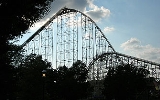
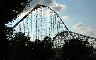 South Whitehall Township is best known as the home of Dorney Park and Wildwater Kingdom
, a popular area amusement park.
in the 16th district and US Representative Charlie Dent
in the 15th district. State Representative Julie Harhart
serves the 1st, 2nd, 6th, 7th, and 8th wards in the 183rd district and State Representative Doug Reichley
serves the 3rd, 4th, and 5th wards in the 134th district. All of its legislators are Republican.
. Students in grades 9 through 12 attend Parkland High School
, located on Cedar Crest Boulevard in the township. Both of the Middle Schools (Orefield
and Springhouse
) are in South Whitehall, as are Cetronia
, Kratzer, and Parkway Manor
Elementary Schools. Some of the township's students attend Kernsville Elementary just over the North Whitehall line. Kratzer is located in Greenawalds. http://www.parklandsd.org/about/district-map
Township (Pennsylvania)
A township in the Commonwealth of Pennsylvania, a state of the United States of America, is one of four types of municipalities in the state . Townships were established based on convenient geographical boundaries and vary in size from six to forty square miles...
in Lehigh County
Lehigh County, Pennsylvania
-Climate:Most of the county's climate is considered to fall in the humid continental climate zone. Summers are typically hot and muggy, fall and spring are generally mild, and winter is cold. Precipitation is almost uniformly distributed throughout the year....
, Pennsylvania
Pennsylvania
The Commonwealth of Pennsylvania is a U.S. state that is located in the Northeastern and Mid-Atlantic regions of the United States. The state borders Delaware and Maryland to the south, West Virginia to the southwest, Ohio to the west, New York and Ontario, Canada, to the north, and New Jersey to...
, in the United States
United States
The United States of America is a federal constitutional republic comprising fifty states and a federal district...
. It is a suburb of Allentown
Allentown, Pennsylvania
Allentown is a city located in Lehigh County, Pennsylvania, in the United States. It is Pennsylvania's third most populous city, after Philadelphia and Pittsburgh, and the 215th largest city in the United States. As of the 2010 census, the city had a total population of 118,032 and is currently...
, Pennsylvania
Pennsylvania
The Commonwealth of Pennsylvania is a U.S. state that is located in the Northeastern and Mid-Atlantic regions of the United States. The state borders Delaware and Maryland to the south, West Virginia to the southwest, Ohio to the west, New York and Ontario, Canada, to the north, and New Jersey to...
, in the Lehigh Valley
Lehigh Valley
The Lehigh Valley, known officially by the United States Census Bureau as the Allentown-Bethlehem-Easton, PA-NJ metropolitan area and referred to locally as The Valley and A-B-E, is a metropolitan region consisting of Lehigh, Northampton, Berks, and Carbon counties in eastern Pennsylvania and...
area of the state. The population of South Whitehall Township was 18,028 at the 2000 census. It is home to the Lehigh Valley interchange of the Northeast Extension of the Pennsylvania Turnpike
Pennsylvania Turnpike
The Pennsylvania Turnpike is a toll highway system operated by the Pennsylvania Turnpike Commission in the Commonwealth of Pennsylvania, United States. The three sections of the turnpike system total . The main section extends from Ohio to New Jersey and is long...
.
History
The first settlers of the Lehigh Valley region were Germans who emigrated from earlier settlements along the Perkiomen CreekPerkiomen Creek
Perkiomen Creek is a tributary of the Schuylkill River in Berks, Lehigh and Montgomery counties in Pennsylvania in the United States.Perkiomen Creek begins in Hereford Township, Berks County, initially flows eastward into Upper Milford Township, Lehigh County, and turns southward to reenter...
. The earliest settlers arrived in the region over a 20-year period beginning in about 1732. The immigration of the Germans and other European natives, including Swiss and Huguenots, was aided by William Penn
William Penn
William Penn was an English real estate entrepreneur, philosopher, and founder of the Province of Pennsylvania, the English North American colony and the future Commonwealth of Pennsylvania. He was an early champion of democracy and religious freedom, notable for his good relations and successful...
and his friends. The land lying south of the South Mountain
South Mountain (eastern Pennsylvania)
South Mountain is a colloquial name applied to features in the mountain range extending south and south west from the Lehigh Valley to the Lebanon Valley regions of Pennsylvania. At times, it also been known as Durham Hills, Reading Hills, and the Lehigh Mountains...
was given to William Penn in 1713 by the Lenni Lenape Indians. The land of Lehigh County lying between the Blue Mountain
Blue Mountain (Pennsylvania)
Blue Mountain is a ridge that forms the eastern edge of the Appalachian mountain range in the U.S. state of Pennsylvania. It cuts across the eastern half of the state from New Jersey to Maryland, providing a distinct boundary between a number of Pennsylvania's geographical and cultural regions...
and the Lehigh Mountains was given to Penn's sons by the Lenni Lenapes in 1732. Emigrants sought the fertile, limestone valley flanking rivers and streams such as the Jordan Creek.
One of the earliest tracts of land purchased in the Township was by Nicholas Kern who bought tracts of land on December 3, 1735 and October 28, 1737. Some of this was sold to Lorenz Guth on February 27, 1739. Guth continued to buy land in the area of the Reformed church property and also in the Guthsville area. By 1769 his holdings totaled 759 acres (3.1 km²). The Lorenz Guth house near Wehr's Dam still stands in excellent condition and is a fine example of colonial architecture.
Much of the history of South Whitehall can be traced to the Walbert-Guthsville region, and especially the two Jordan churches. The first ministration to the Lutheran
Lutheranism
Lutheranism is a major branch of Western Christianity that identifies with the theology of Martin Luther, a German reformer. Luther's efforts to reform the theology and practice of the church launched the Protestant Reformation...
people in the township occurred in 1734 when Reverend John Casper Stoever baptized Margaret, the daughter of the John Lichtenwalners, on February 6. In 1736 a Reverend Schmidt preached occasionally to the Lutherans, and in 1739 Reverend John Justus Jacob Birkenstock became pastor of the Jordan Lutheran congregation. In 1845 it was noted that the centennial of the congregation was observed, which would indicate that the first building was erected in 1745. The first church building was of logs and stood near the north wall of the old burial ground. It was used jointly by the Lutheran and Reformed congregations until about 1752 when the Reformed erected a building half a mile to the east, within sight of the current municipal building. The Lutherans built the present church in 1842-1843 at a cost of $3,581.24. It was renovated in 1868, and in 1886 a fine, shapely, slate-covered steeple, 138 feet (42.1 m) high, was erected.
Members of the Reformed (United Church of Christ) religion settled in the area as early as 1738, and baptisms of their children during the period of 1740 to 1752 are recorded in the Lutheran record book. In 1752 Lorenz Guth presented the Reformed with a 50 acres (202,343 m²) tract of land, and a log church was erected in six weeks. The second and present church building, with its 110 feet (33.5 m) steeple was built in 1808. It stands as one of the oldest church buildings in the country, and is a fine example of the architecture of that period.
The early schools of the township were connected with the two Jordan churches for many years, possibly extending back to 1739. According to the Roberts history, the congregations were at first supplied not by pastors, but by teachers who used to read sermons on Sundays. Thus, it is possible that church-sponsored schools taught by the readers existed in the earliest days of the congregations.
The original name "Whitehall" dates to 1740 and encompasses the land now found in North Whitehall
North Whitehall Township, Pennsylvania
North Whitehall Township is a township in Lehigh County, Pennsylvania, in the United States. It is a suburb of Allentown, Pennsylvania, in the Lehigh Valley region of the state.The population of North Whitehall Township was 14,731 at the 2000 census....
, South Whitehall, and Whitehall Township
Whitehall Township, Pennsylvania
Whitehall Township is a township in Lehigh County, Pennsylvania, in the United States. It is a suburb of Allentown, Pennsylvania, in the Lehigh Valley region of the state.The population of Whitehall Township was 24,896 at the 2000 census.-Geography:...
s. Prior to the establishment of Northampton County
Northampton County, Pennsylvania
As of the 2010 census, the county was 86.3% White, 5.0% Black or African American, 0.2% Native American or Alaskan Native, 2.4% Asian, 0.0% Native Hawaiian, 2.2% were two or more races, and 3.8% were some other race. 10.5% of the population were of Hispanic or Latino ancestry.As of the census of...
in 1752, the area was part of Bucks County
Bucks County, Pennsylvania
- Industry and commerce :The boroughs of Bristol and Morrisville were prominent industrial centers along the Northeast Corridor during World War II. Suburban development accelerated in Lower Bucks in the 1950s with the opening of Levittown, Pennsylvania, the second such "Levittown" designed by...
and the land currently occupied by South Whitehall was known as "the back part of Macungie" on the "Heidelberg District." The name Whitehall is thought to be derived from one of two sources: either a place in England, or for a white house erected as a hunting lodge near the Jordan and Cedar Creeks.
South Whitehall Township was established in 1810 by a petition to the Northampton County Court to divide former Whitehall Township into two areas, North Whitehall and South Whitehall Townships. In 1812, Lehigh County was divided off from the original Northampton County, establishing South Whitehall Township within and nearly at the center of Lehigh County. At that time, according to historians, "...many prominent and influential men who lived in the vicinity of Guthsville exerted themselves to secure the selection of the village as the place best adapted for the county seat on account of its situation in the geographical center of the large area of territory to be erected into a separate county, but their efforts proved unavailing and the advocates of Allentown were successful." (The quotations from Roberts History published in 1914.)
Agriculture was the backbone of the economy of the township for many years. Much of the land today still is under cultivation. For more than a century at least six grain mills flourished on the Jordan and Cedar Creek
Cedar Creek
-In Delaware:*Cedar Creek, Delaware*Cedar Creek Hundred, an unincorporated subdivision of Sussex County, Delaware-In Georgia:*Cedar Creek , former name for Vickery Creek, a tributary of the Chattahoochee River-In Indiana:...
s.
In the early 19th century iron ore was discovered at different places in the township and mining operations were carried on from 1820 to 1890.
In 1867, the eastern portion of South Whitehall and the southeastern portion of North Whitehall were detached and formed into Whitehall Township.
In 1966, South Whitehall became a First Class Township.
Geography
According to the United States Census BureauUnited States Census Bureau
The United States Census Bureau is the government agency that is responsible for the United States Census. It also gathers other national demographic and economic data...
, the township has a total area of 17.2 square miles (44.6 km²), of which, 17.1 square miles (44.3 km²) of it is land and 0.1 square miles (0.2 km²) of it (0.46%) is water. The township is located immediately west of Allentown and approximately 55 miles (88.5 km) northwest of Philadelphia. It is drained by the Jordan Creek and the Little Lehigh Creek
Little Lehigh Creek
The Little Lehigh Creek is approximately long, in eastern Pennsylvania, in the United States. It is also sometimes referred to as the Little Lehigh River. It is called the Little Lehigh because it is the largest tributary of the Lehigh River....
into the Lehigh River
Lehigh River
The Lehigh River, a tributary of the Delaware River, is a river located in eastern Pennsylvania, in the United States. Part of the Lehigh, along with a number of its tributaries, is designated a Pennsylvania Scenic River by the state's Department of Conservation and Natural Resources...
.
The Lehigh Valley interchange of Interstate 476
Interstate 476
Interstate 476 is a auxiliary Interstate Highway in the U.S. state of Pennsylvania designated between Interstate 95 near Chester and Interstate 81 near Scranton, serving as the primary north–south Interstate corridor through eastern Pennsylvania....
and U.S. Route 22
U.S. Route 22
U.S. Route 22 is a west–east route and is one of the original United States highways of 1926, running from Cincinnati, Ohio, at US 27, US 42, US 127, and US 52 to Newark, New Jersey, at U.S. Route 1/9 near the Newark Liberty International Airport.US 22 also carries the names of the William...
is in the western part of the township. Other north-to-south throughfares are Highway 309
Pennsylvania Route 309
Pennsylvania Route 309 is a major highway which runs for 134 miles through Pennsylvania in the United States. It connects Philadelphia and its northern suburbs to Allentown, Hazleton, and Wilkes-Barre. A limited-access highway portion of PA 309 in the Wilkes-Barre area is known as the North...
, Cedar Crest Boulevard, and Mauch Chunk Road, while other east-to-west thoroughfares are Walbert Avenue and Tilghman Street. South Whitehall's villages include Cetronia
Cetronia, Pennsylvania
Cetronia is an unincorporated community in South Whitehall Township, Lehigh County, Pennsylvania, United States, near the city of Allentown. State Route 1002 , Pennsylvania Route 309, and Cedar Crest Boulevard run through Cetronia....
, Crackersport, Dorneyville
Dorneyville, Pennsylvania
Dorneyville is an unincorporated town located in Lehigh County, Pennsylvania, USA. The town is located between Allentown, Pennsylvania and Trexlertown, Pennsylvania in South Whitehall Township. Dorneyville is located off Interstate 78 and is home to the northern terminus of U.S. Route 222. It is...
, Greenawalds, Guthsville, Mechanicsville (also in North Whitehall,) Meyersville (also in North Whitehall,) Orefield
Orefield, Pennsylvania
Orefield is a small unincorporated community in Lehigh County, Pennsylvania, United States, split between North Whitehall and South Whitehall township. Located along Pennsylvania Route 309, Orefield has the zip code of 18069. Its name is derived from the extensive deposits of limonite once mined...
(also in North Whitehall,) Parkway Manor, Scherersville (also in Whitehall Township,) Walbert
Walbert, Pennsylvania
Walbert, Pennsylvania is a small village that hosts the municipal offices of South Whitehall Township, Lehigh County. It is located on Route 309 and has easy access to 22, 78, and 476. It is split between the Allentown zip code of 18104 and the Orefield zip code of 18069. It is drained by the...
, and Woodlawn.
Adjacent municipalities
- Upper Macungie Township (southwest)
- Lower Macungie Township (south)
- Salisbury TownshipSalisbury Township, Lehigh County, PennsylvaniaSalisbury Township is a township in Lehigh County, Pennsylvania, in the United States. The township borders Allentown Bethlehem, and Emmaus, in the Lehigh Valley region....
(south) - AllentownAllentown, PennsylvaniaAllentown is a city located in Lehigh County, Pennsylvania, in the United States. It is Pennsylvania's third most populous city, after Philadelphia and Pittsburgh, and the 215th largest city in the United States. As of the 2010 census, the city had a total population of 118,032 and is currently...
(southeast) - Whitehall TownshipWhitehall Township, PennsylvaniaWhitehall Township is a township in Lehigh County, Pennsylvania, in the United States. It is a suburb of Allentown, Pennsylvania, in the Lehigh Valley region of the state.The population of Whitehall Township was 24,896 at the 2000 census.-Geography:...
(northeast) - North Whitehall TownshipNorth Whitehall Township, PennsylvaniaNorth Whitehall Township is a township in Lehigh County, Pennsylvania, in the United States. It is a suburb of Allentown, Pennsylvania, in the Lehigh Valley region of the state.The population of North Whitehall Township was 14,731 at the 2000 census....
(north) - Lowhill TownshipLowhill Township, PennsylvaniaLowhill Township is a township in Lehigh County, Pennsylvania, in the United States. It is a suburb of Allentown, Pennsylvania, in the Lehigh Valley region of the state.The population of Lowhill Township was 1,869 at the 2000 census.-Geography:...
(tangent to the west)
Demographics
As of the censusCensus
A census is the procedure of systematically acquiring and recording information about the members of a given population. It is a regularly occurring and official count of a particular population. The term is used mostly in connection with national population and housing censuses; other common...
of 2000, there were 18,028 people, 6,943 households, and 5,019 families residing in the township. The population density
Population density
Population density is a measurement of population per unit area or unit volume. It is frequently applied to living organisms, and particularly to humans...
was 1,052.8 people per square mile (406.6/km²). There were 7,154 housing units at an average density of 417.8/sq mi (161.3/km²). The racial makeup of the township was 95.67% White, 1.02% African American, 0.03% Native American, 2.07% Asian, 0.44% from other races
Race (United States Census)
Race and ethnicity in the United States Census, as defined by the Federal Office of Management and Budget and the United States Census Bureau, are self-identification data items in which residents choose the race or races with which they most closely identify, and indicate whether or not they are...
, and 0.77% from two or more races. Hispanic or Latino of any race were 1.51% of the population.
There were 6,943 households out of which 29.5% had children under the age of 18 living with them, 62.9% were married couples
Marriage
Marriage is a social union or legal contract between people that creates kinship. It is an institution in which interpersonal relationships, usually intimate and sexual, are acknowledged in a variety of ways, depending on the culture or subculture in which it is found...
living together, 7.2% had a female householder with no husband present, and 27.7% were non-families. 24.8% of all households were made up of individuals and 15.4% had someone living alone who was 65 years of age or older. The average household size was 2.45 and the average family size was 2.92.
In the township the population was spread out with 21.4% under the age of 18, 4.6% from 18 to 24, 22.4% from 25 to 44, 27.0% from 45 to 64, and 24.5% who were 65 years of age or older. The median age was 46 years. For every 100 females there were 85.5 males. For every 100 females age 18 and over, there were 80.6 males.
The median income for a household in the township was $54,759, and the median income for a family was $64,291. Males had a median income of $46,963 versus $30,345 for females. The per capita income
Per capita income
Per capita income or income per person is a measure of mean income within an economic aggregate, such as a country or city. It is calculated by taking a measure of all sources of income in the aggregate and dividing it by the total population...
for the township was $27,486. About 3.1% of families and 3.9% of the population were below the poverty line, including 5.7% of those under age 18 and 4.8% of those age 65 or over.
Recreation
Dorney Park & Wildwater Kingdom
Dorney Park & Wildwater Kingdom is an American amusement and water park located in Allentown, Pennsylvania. The park features nine roller coasters, other adult and children's rides, and a waterpark, Wildwater Kingdom....
, a popular area amusement park.
Government and politics
South Whitehall is represented by State Senator Pat BrownePat Browne
Patrick M. Browne is a Republican member of the Pennsylvania State Senate who has represented the 16th District since 2005. His district includes portions of Lehigh County, Monroe County and Northampton County....
in the 16th district and US Representative Charlie Dent
Charlie Dent
Charles "Charlie" Dent is the U.S. Representative for , serving since 2005. He is a member of the Republican Party.The district includes all of Northampton County, most of Lehigh County, and small parts of Berks and Montgomery Counties....
in the 15th district. State Representative Julie Harhart
Julie Harhart
Julie Harhart has represented the 183rd Legislative District of Pennsylvania, USA, since 1994. She is the Republican Chairman of the House Local Government Committee and a member of the House Professional Licensure Committee.-Personal:...
serves the 1st, 2nd, 6th, 7th, and 8th wards in the 183rd district and State Representative Doug Reichley
Doug Reichley
Douglas "Doug" Reichley is a politician from the U.S. state of Pennsylvania; he was elected to the Pennsylvania House of Representatives in 2002, representing the 134th district. He sits on the House Appropriations, Consumer Affairs, Health and Human Services and Professional Licensure Committees...
serves the 3rd, 4th, and 5th wards in the 134th district. All of its legislators are Republican.
Board of Commissioners
South Whitehall elects five at-large commissioners for four-year terms.- Brad Osborne, President
- Howard Ellsworth, Vice-President
- Christina "Tori" Morgan, Assistant Secretary
- Dale W. Daubert
- Thomas J. Johns
Public education
The Township is served by the Parkland School DistrictParkland School District
Parkland School District is a public school district located in Lehigh County, Pennsylvania, USA. It serves North Whitehall, South Whitehall, and Upper Macungie Townships, as well as the Trexler Park neighborhood in West Allentown.-High school:...
. Students in grades 9 through 12 attend Parkland High School
Parkland High School (Allentown, Pennsylvania)
Parkland High School, located near Allentown, Pennsylvania, United States, is a public high school serving students in grades 9 to 12. It is the only high school for the Parkland School District....
, located on Cedar Crest Boulevard in the township. Both of the Middle Schools (Orefield
Orefield Middle School
Renovated in 2001, Orefield Middle School has a half-century serving the students in the Parkland School District in Pennsylvania. Built as the Parkland Junior Senior High School in 1953, the school opened in 1954 for 1,157 students in grades seven through twelve. As enrollment grew, seventh and...
and Springhouse
Springhouse Middle School
Springhouse Middle School is a school in Allentown, Pennsylvania, United States.Springhouse Middle School [SMS] was built in 1971 as Parkland School District’s second junior high school for grades six, seven, and eight with a building of approximately located on...
) are in South Whitehall, as are Cetronia
Cetronia Elementary School
Cetronia Elementary School is an elementary school in Allentown, Pennsylvania. It was first named the James W. Good Grade School and dedicated in September, 1930. In 1961 an addition was added to the east side of the building. The structure was renamed Cetronia reflecting the geographic area in...
, Kratzer, and Parkway Manor
Parkway Manor Elementary School
Construction of the Parkway Manor Elementary School began in 1959 as the first step in a $3 million dollar renovation program to district buildings. Briefly known as the Calvin S...
Elementary Schools. Some of the township's students attend Kernsville Elementary just over the North Whitehall line. Kratzer is located in Greenawalds. http://www.parklandsd.org/about/district-map