

South Western Highway
Encyclopedia
South Western Highway is a highway in the South West region of Western Australia
connecting Perth
's southeast with Walpole
. It is a part of the National Highway 1
network for most of its length. It is about 406 kilometres (252 mi) long.
junction in Armadale
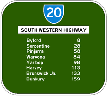
, 28 km from Perth, and follows a north-south route 20–30 km inland from the coast, passing through several agricultural and timber towns that sprang up in the 1890s when the nearby railway came through, such as Pinjarra
, Waroona
, Yarloop
and Harvey
.
Just past Brunswick Junction
, the highway heads southwest towards Western Australia's third-largest city, Bunbury
. The typical scenery on this part of the highway includes small dairy farms and orchards, jarrah
and marri
remnant forests and pine plantations.
Until the 1980s, the Armadale-Bunbury section was part of National Highway 1
, but following the upgrading of Old Coast Road
and construction of the Mandurah bypass, Highway 1 now follows the coastal route via Kwinana Freeway
and Old Coast Road to Bunbury passing through the resort town of Mandurah
.
. The highway actually used to follow what is now Boyanup-Picton Road from Picton via Dardanup, but changed to the present shorter route in the 1980s.
, the heart of WA's apple
country. From then on the highway passes through thick forests featuring many native trees like jarrah
, marri
and karri
. The region was settled much later than other parts of south western WA, under a soldier resettlement scheme in the 1920s. Typical scenery is farmland interspersed with forests and small timber towns.
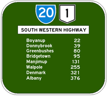
The highway then goes through Bridgetown
(where it meets the Brockman Highway
from Augusta
and Nannup
), Manjimup
and finally to Walpole
. This part of the highway, especially from Manjimup, is sparsely populated and very thickly forested, with abundant wildlife and wildflower
s as well as many old growth trees, especially the giant karri
.
From Walpole, the Highway 1 continues as South Coast Highway
to Albany
.

Western Australia
Western Australia is a state of Australia, occupying the entire western third of the Australian continent. It is bounded by the Indian Ocean to the north and west, the Great Australian Bight and Indian Ocean to the south, the Northern Territory to the north-east and South Australia to the south-east...
connecting Perth
Perth, Western Australia
Perth is the capital and largest city of the Australian state of Western Australia and the fourth most populous city in Australia. The Perth metropolitan area has an estimated population of almost 1,700,000....
's southeast with Walpole
Walpole, Western Australia
Walpole is a town in Western Australia, 432 km SSE of Perth and 66 km west of Denmark.Walpole lies very close to the northern point of the 100-hectare Walpole Inlet, from which it takes its name....
. It is a part of the National Highway 1
Highway 1 (Australia)
Australia's Highway 1 is a network of highways that circumnavigate the Australian continent, joining all mainland state capitals. At a total length of approximately it is the longest national highway in the world, longer than the Trans-Siberian Highway and the Trans-Canada Highway...
network for most of its length. It is about 406 kilometres (252 mi) long.
Perth to Bunbury
From Perth, the highway, signed as State Route 20, starts from the Albany HighwayAlbany Highway
Albany Highway is a generally northwest-southeast highway in the south of Western Australia which links the state's capital Perth with its oldest settlement, Albany. The highway is approximately in length, is designated State Route 30 and separates Western Australia's Great Southern region from...
junction in Armadale
Armadale, Western Australia
Armadale is a suburb within the City of Armadale, located on the south-eastern edge of Perth's metropolitan area. The major junction of the South Western and Albany Highways, which connect Perth with the South West and Great Southern regions of Western Australia respectively, is located within the...
, 28 km from Perth, and follows a north-south route 20–30 km inland from the coast, passing through several agricultural and timber towns that sprang up in the 1890s when the nearby railway came through, such as Pinjarra
Pinjarra, Western Australia
Pinjarra is a town in the Peel region of Western Australia along the South Western Highway, from the state capital, Perth and south-east of the coastal city of Mandurah. Its local government area is the Shire of Murray. At the 2006 census, Pinjarra had a population of 3,279.Pinjarra is an area...
, Waroona
Waroona, Western Australia
Waroona is a town located in the Peel region of Western Australia along the South Western Highway, between Pinjarra and Harvey. The town is the seat of the Shire of Waroona. At the 2006 census, Waroona had a population of 1,864.-History:...
, Yarloop
Yarloop, Western Australia
Yarloop is a town located in the South West of Western Australia along the South Western Highway, between Waroona and Harvey. At the 2006 census, Yarloop had a population of 545.-History:...
and Harvey
Harvey, Western Australia
Harvey is a town located in the South West of Western Australia along the South Western Highway, 140 km south of Perth, between Pinjarra and Bunbury...
.
Just past Brunswick Junction
Brunswick Junction, Western Australia
Brunswick Junction is a town located in the South West of Western Australia along the South Western Highway, between Harvey and Bunbury.-History:...
, the highway heads southwest towards Western Australia's third-largest city, Bunbury
Bunbury, Western Australia
The port city of Bunbury is the third largest city in Western Australia after the State Capital Perth and Mandurah. It is situated south of Perth's central business district...
. The typical scenery on this part of the highway includes small dairy farms and orchards, jarrah
Jarrah
Eucalyptus marginata is one of the most common species of Eucalyptus tree in the southwest of Western Australia. The tree and the wood are usually referred to by the Aboriginal name Jarrah...
and marri
Corymbia ficifolia
Corymbia ficifolia or the red flowering gum also known as Albany red flowering gum is one of the most commonly planted ornamental trees in the broader eucalyptus family....
remnant forests and pine plantations.
Until the 1980s, the Armadale-Bunbury section was part of National Highway 1
Highway 1 (Australia)
Australia's Highway 1 is a network of highways that circumnavigate the Australian continent, joining all mainland state capitals. At a total length of approximately it is the longest national highway in the world, longer than the Trans-Siberian Highway and the Trans-Canada Highway...
, but following the upgrading of Old Coast Road
Old Coast Road
Old Coast Road is a Western Australian highway linking Mandurah, WA's second-largest city located 75 km south of Perth, with Bunbury, WA's third-largest city. It is signed as Route 1 for most of its length and is long.-Overview:...
and construction of the Mandurah bypass, Highway 1 now follows the coastal route via Kwinana Freeway
Kwinana Freeway
The Kwinana Freeway is a major arterial road in Perth, Western Australia, linking Perth with the southern suburbs and then further on towards Mandurah, a distance of . It has a speed limit of , except in central Perth and south of Lakes Road . Like all Western Australian freeways, the minimum...
and Old Coast Road to Bunbury passing through the resort town of Mandurah
Mandurah, Western Australia
Mandurah is the second-largest city in Western Australia and is located approximately south of the state capital, Perth.The city attracts a large number of tourists, including many international visitors...
.
In Bunbury
The highway does not actually enter Bunbury - it stops at the industrial suburb of Picton, following Robertson Drive (Bunbury's ring road) for 1 km south before turning southeast past Bunbury Airport towards BoyanupBoyanup, Western Australia
Boyanup is a town located on the South Western Highway in the South West agricultural region, 195 km south of Perth and 18 km south-east of Bunbury, Western Australia....
. The highway actually used to follow what is now Boyanup-Picton Road from Picton via Dardanup, but changed to the present shorter route in the 1980s.
Bunbury to Walpole
From Bunbury, the highway goes through Boyanup and on to DonnybrookDonnybrook, Western Australia
-Tourism:Donnybrook has many town icons bearing the apple. On the main street, apple-shaped lights line the entrance of the Old Railway Station. These lights have recently been restored. Atop the east Donnybrook hill is a high tower with an apple at the top...
, the heart of WA's apple
Apple
The apple is the pomaceous fruit of the apple tree, species Malus domestica in the rose family . It is one of the most widely cultivated tree fruits, and the most widely known of the many members of genus Malus that are used by humans. Apple grow on small, deciduous trees that blossom in the spring...
country. From then on the highway passes through thick forests featuring many native trees like jarrah
Jarrah
Eucalyptus marginata is one of the most common species of Eucalyptus tree in the southwest of Western Australia. The tree and the wood are usually referred to by the Aboriginal name Jarrah...
, marri
Corymbia ficifolia
Corymbia ficifolia or the red flowering gum also known as Albany red flowering gum is one of the most commonly planted ornamental trees in the broader eucalyptus family....
and karri
Karri
Eucalyptus diversicolor, commonly known as the Karri, is a eucalypt which is native to the wetter regions of south west of Western Australia.-Description:...
. The region was settled much later than other parts of south western WA, under a soldier resettlement scheme in the 1920s. Typical scenery is farmland interspersed with forests and small timber towns.
The highway then goes through Bridgetown
Bridgetown, Western Australia
-Notable people:*Emily Barker, singer-songwriter*Jon Doust, author and comedian*Robyn McSweeney, politician*Tom O'Dwyer, cricketer*David Reid, politician*Deborah Robertson, novelist and poet-External links:* * * * * * * *...
(where it meets the Brockman Highway
Brockman Highway
Brockman Highway is a highway in Western Australia. A few hours south of Perth, it runs west from Bridgetown via Nannup to Karridale.Nannup is situated at the junction of the Vasse Highway and the Brockman Highway....
from Augusta
Augusta, Western Australia
Augusta is a town on the south-west coast of Western Australia, where the Blackwood River emerges into Flinders Bay. It is the nearest town to Cape Leeuwin, on the farthest south-west corner of the Australian continent. In the 2001 census it had a population of 1,694; by 2006 the population of...
and Nannup
Nannup, Western Australia
Nannup is a town and shire in the South West region of Western Australia, approximately south of Perth on the Blackwood River at the crossroads of Vasse Highway and Brockman Highway, linking Nannup to most of the Lower South West's regional centres...
), Manjimup
Manjimup, Western Australia
Manjimup is a town in Western Australia, south of the state capital, Perth. The town of Manjimup is a regional centre for the largest shire in the South West of Western Australia. At the 2006 census, Manjimup had a population of 4,239.-History:...
and finally to Walpole
Walpole, Western Australia
Walpole is a town in Western Australia, 432 km SSE of Perth and 66 km west of Denmark.Walpole lies very close to the northern point of the 100-hectare Walpole Inlet, from which it takes its name....
. This part of the highway, especially from Manjimup, is sparsely populated and very thickly forested, with abundant wildlife and wildflower
Wildflower
A wildflower is a flower that grows wild, meaning it was not intentionally seeded or planted. Yet "wildflower" meadows of a few mixed species are sold in seed packets. The term "wildflower" has been made vague by commercial seedsmen who are interested in selling more flowers or seeds more...
s as well as many old growth trees, especially the giant karri
Karri
Eucalyptus diversicolor, commonly known as the Karri, is a eucalypt which is native to the wetter regions of south west of Western Australia.-Description:...
.
From Walpole, the Highway 1 continues as South Coast Highway
South Coast Highway
South Coast Highway is a Western Australia highway. It is a part of the Highway 1 network.With a length of , it runs from Esperance to Walpole roughly in parallel to the Western Australia's south coast...
to Albany
Albany, Western Australia
Albany is a port city in the Great Southern region of Western Australia, some 418 km SE of Perth, the state capital. As of 2009, Albany's population was estimated at 33,600, making it the 6th-largest city in the state....
.
Major towns
- ArmadaleArmadale, Western AustraliaArmadale is a suburb within the City of Armadale, located on the south-eastern edge of Perth's metropolitan area. The major junction of the South Western and Albany Highways, which connect Perth with the South West and Great Southern regions of Western Australia respectively, is located within the...
- ByfordByford, Western AustraliaByford is a suburb on the southeastern edge of Perth, Australia, originally founded as the townsite of Beenup in 1906.Beenup took its name from the railway siding there, a corruption of the Aboriginal name of nearby Beenyup Brook...
- PinjarraPinjarra, Western AustraliaPinjarra is a town in the Peel region of Western Australia along the South Western Highway, from the state capital, Perth and south-east of the coastal city of Mandurah. Its local government area is the Shire of Murray. At the 2006 census, Pinjarra had a population of 3,279.Pinjarra is an area...
- WaroonaWaroona, Western AustraliaWaroona is a town located in the Peel region of Western Australia along the South Western Highway, between Pinjarra and Harvey. The town is the seat of the Shire of Waroona. At the 2006 census, Waroona had a population of 1,864.-History:...
- YarloopYarloop, Western AustraliaYarloop is a town located in the South West of Western Australia along the South Western Highway, between Waroona and Harvey. At the 2006 census, Yarloop had a population of 545.-History:...
- HarveyHarvey, Western AustraliaHarvey is a town located in the South West of Western Australia along the South Western Highway, 140 km south of Perth, between Pinjarra and Bunbury...
- Brunswick JunctionBrunswick Junction, Western AustraliaBrunswick Junction is a town located in the South West of Western Australia along the South Western Highway, between Harvey and Bunbury.-History:...
- BunburyBunbury, Western AustraliaThe port city of Bunbury is the third largest city in Western Australia after the State Capital Perth and Mandurah. It is situated south of Perth's central business district...
- BoyanupBoyanup, Western AustraliaBoyanup is a town located on the South Western Highway in the South West agricultural region, 195 km south of Perth and 18 km south-east of Bunbury, Western Australia....
- DonnybrookDonnybrook, Western Australia-Tourism:Donnybrook has many town icons bearing the apple. On the main street, apple-shaped lights line the entrance of the Old Railway Station. These lights have recently been restored. Atop the east Donnybrook hill is a high tower with an apple at the top...
- BridgetownBridgetown, Western Australia-Notable people:*Emily Barker, singer-songwriter*Jon Doust, author and comedian*Robyn McSweeney, politician*Tom O'Dwyer, cricketer*David Reid, politician*Deborah Robertson, novelist and poet-External links:* * * * * * * *...
- ManjimupManjimup, Western AustraliaManjimup is a town in Western Australia, south of the state capital, Perth. The town of Manjimup is a regional centre for the largest shire in the South West of Western Australia. At the 2006 census, Manjimup had a population of 4,239.-History:...
- WalpoleWalpole, Western AustraliaWalpole is a town in Western Australia, 432 km SSE of Perth and 66 km west of Denmark.Walpole lies very close to the northern point of the 100-hectare Walpole Inlet, from which it takes its name....
Armadale to Picton
- Interchange, ArmadaleArmadale, Western AustraliaArmadale is a suburb within the City of Armadale, located on the south-eastern edge of Perth's metropolitan area. The major junction of the South Western and Albany Highways, which connect Perth with the South West and Great Southern regions of Western Australia respectively, is located within the...
and BedfordaleBedfordale, Western AustraliaBedfordale is a semi-rural suburb in the south east of Perth, Western Australia, located within the City of Armadale. Located approximately 40km from Perth in the Darling Range, some of the local attractions include Churchman Brook Dam, Wungong Dam and the Elizabethan Pub. . The area is popular for...
-
 Armadale Road to Jandakot and SpearwoodSpearwood, Western AustraliaSpearwood is a southern suburb of Perth, Western Australia, located within the City of Cockburn. It was named by colonial settlers who noticed the native tea trees, scientific name Melaleuca lanceolata Chipolata, being used for spears by the Yugul Aboriginal people.-History:Settlement appears to...
 -
 Albany HighwayAlbany HighwayAlbany Highway is a generally northwest-southeast highway in the south of Western Australia which links the state's capital Perth with its oldest settlement, Albany. The highway is approximately in length, is designated State Route 30 and separates Western Australia's Great Southern region from...
to Perth via GosnellsGosnells, Western AustraliaThe City of Gosnells is a Local Government Area in the southeastern suburbs of the Western Australian capital city of Perth, located northwest of Armadale and about southeast of Perth's central business district...
, CanningtonCannington, Western AustraliaCannington is a southern suburb of Perth, Western Australia. Its Local Government Area is the City of Canning.-History:Cannington's name derives from the Canning River, which forms part of the southwestern boundary of the suburb...
and Victoria ParkVictoria Park, Western AustraliaThe Town of Victoria Park is a Local Government Area of Western Australia. It covers an area of 17.62 km² in metropolitan Perth, the capital of Western Australia. The Town of Victoria Park maintains 154.55 km of roads, a little over 1 km² of parks and gardens and has a... - Albany HighwayAlbany HighwayAlbany Highway is a generally northwest-southeast highway in the south of Western Australia which links the state's capital Perth with its oldest settlement, Albany. The highway is approximately in length, is designated State Route 30 and separates Western Australia's Great Southern region from...
to WilliamsWilliams, Western AustraliaWilliams is a town located in the Wheatbelt region of Western Australia, south-southeast of the state capital, Perth along Albany Highway and 32 kilometres west of Narrogin. The Williams River passes through the town. At the 2006 census, Williams had a population of 338.-History:Williams is...
, KojonupKojonup, Western AustraliaKojonup is a town located 256 km south-east of Perth, Western Australia along Albany Highway.The name Kojonup is believed to refer to the "Kodja" or stone axe made by Indigenous Australians from the local stone....
and AlbanyAlbany, Western AustraliaAlbany is a port city in the Great Southern region of Western Australia, some 418 km SE of Perth, the state capital. As of 2009, Albany's population was estimated at 33,600, making it the 6th-largest city in the state....
-
-
 (at Byford) Thomas Road to KwinanaKwinana, Western AustraliaThe Town of Kwinana is a Local Government Area of Western Australia. It covers an area of approximately 118 square kilometres in metropolitan Perth, and lies about 38 km south of Perth's central business district, via the Kwinana Freeway...
and RockinghamRockingham, Western AustraliaRockingham is a suburb and primary centre in Western Australia south-west of the Perth city centre and south of Fremantle. It has a beachside location at Mangles Bay, the southern extremity of Cockburn Sound. To its north stretches the maritime and resource-industry installations of Kwinana and... -
 (at Mundijong)Watkins Road (Goes onto Mundijong Road) to BaldivisBaldivis, Western AustraliaBaldivis is a semi-rural residential suburb south of the central business district of Perth, the capital of Western Australia, and southeast of the regional centre of Rockingham...
and Jarrahdale Road to JarrahdaleJarrahdale, Western AustraliaJarrahdale is a small historic town located 50 km south-east of Perth, Western Australia in the Darling Range. Jarrahdale is a descriptive name, derived from its situation in some of Western Australia's best Jarrah forest... - (at North Dandalup)
- Del Park Road to DwellingupDwellingup, Western AustraliaDwellingup is a town in Western Australia, located in a timber and fruitgrowing area in the Darling Range east-south-east of Pinjarra. At the 2006 census, Dwellingup had a population of 346.-Name:...
- Lakes Road to Mandurah
- Del Park Road to Dwellingup
- (at Pinjarra):
- Pinjarra-Williams Road to DwellingupDwellingup, Western AustraliaDwellingup is a town in Western Australia, located in a timber and fruitgrowing area in the Darling Range east-south-east of Pinjarra. At the 2006 census, Dwellingup had a population of 346.-Name:...
and BoddingtonBoddington, Western AustraliaBoddington is a town and shire in the Peel region of Western Australia, located south-east of Perth. The town sits on the road from Pinjarra to Williams on the Hotham River... - Pinjarra Road to MandurahMandurah, Western AustraliaMandurah is the second-largest city in Western Australia and is located approximately south of the state capital, Perth.The city attracts a large number of tourists, including many international visitors...
- Old Bunbury Road to Old Coast RoadOld Coast RoadOld Coast Road is a Western Australian highway linking Mandurah, WA's second-largest city located 75 km south of Perth, with Bunbury, WA's third-largest city. It is signed as Route 1 for most of its length and is long.-Overview:...
Lake CliftonLake Clifton, Western AustraliaLake Clifton is a small town located on the east side of the lake of the same name in the Peel region of Western Australia just off the Old Coast Road, between Mandurah and Bunbury at the north end of the Yalgorup National Park...
- Pinjarra-Williams Road to Dwellingup
- (at Harvey) Uduc Road to Old Coast RoadOld Coast RoadOld Coast Road is a Western Australian highway linking Mandurah, WA's second-largest city located 75 km south of Perth, with Bunbury, WA's third-largest city. It is signed as Route 1 for most of its length and is long.-Overview:...
MyalupMyalup, Western AustraliaMyalup is a town located on the coast in the South West region of Western Australia between Mandurah and Bunbury. At the 2006 census, Myalup had a population of 144.-History:... - (at Brunswick Jn) to Kemerton Industrial ParkKemerton, Western AustraliaKemerton is an industrial park in the Bunbury region of Western Australia, about 10km north-east of Australind. Its Local Government Area is the Shire of Harvey.-Description:...
-
 Coalfields RoadCoalfields RoadCoalfields Highway, formerly known as Coalfields Road, is a Western Australian highway linking Roelands on the South Western Highway with Arthur River on the Albany Highway...
to CollieCollie, Western Australia-External links:*...
and DarkanDarkan, Western AustraliaDarkan is a town located in the Wheatbelt region of Western Australia, between Collie and the Albany Highway on the Coalfields Road. It is also the seat of the Shire of West Arthur. At the 2006 census, Darkan had a population of 203.-History:... - (at Picton) Boyanup-Picton Road to DardanupDardanup, Western AustraliaDardanup is a small town in the South West region of Western Australia. The town is located in the fertile Ferguson valley and is close to the Ferguson River.The area was first settled in 1852 by Thomas Little who named his property Dardanup Park...
-

 Robertson Drive to BunburyBunbury, Western AustraliaThe port city of Bunbury is the third largest city in Western Australia after the State Capital Perth and Mandurah. It is situated south of Perth's central business district...
and (via Bussell HighwayBussell HighwayBussell Highway is a generally north-south highway in the South West of Western Australia. The highway links the city of Bunbury with the town of Augusta and is approximately 150 km in length...
) BusseltonBusselton, Western Australia-Growth and development:According to the Australian Bureau of Statistics the Shire had a permanent resident population of 25,950 in 2004 with the town of Busselton accounting for 67% or 17,400 of the total. The Shire's permanent population is expected to continue to increase significantly to...
and Margaret RiverMargaret River, Western AustraliaMargaret River is a town in the South West of Western Australia, located in the valley of the eponymous Margaret River, south of Perth, the state capital. Its Local Government Area is the Shire of Augusta-Margaret River....
Picton to Walpole
- (at Boyanup) to Stratham
- (at Donnybrook) Goodwood Road to CapelCapel, Western AustraliaCapel is a town in the South West region of Western Australia, located 212 kilometres south of Perth and midway between Bunbury and Busselton....
- (at Bridgetown) Bridgetown Boyup Brook Road to Boyup BrookBoyup Brook, Western AustraliaBoyup Brook is a town located in the south-west of Western Australia, south-southeast of Perth and northeast of Bridgetown.The name Boyup is derived from the name of a nearby pool "Booyup", an Aboriginal term meaning "place of big stones" or "place of big smoke" .The town's economy is...
- (at Bridgetown) Brockman HighwayBrockman HighwayBrockman Highway is a highway in Western Australia. A few hours south of Perth, it runs west from Bridgetown via Nannup to Karridale.Nannup is situated at the junction of the Vasse Highway and the Brockman Highway....
to NannupNannup, Western AustraliaNannup is a town and shire in the South West region of Western Australia, approximately south of Perth on the Blackwood River at the crossroads of Vasse Highway and Brockman Highway, linking Nannup to most of the Lower South West's regional centres...
and AugustaAugusta, Western AustraliaAugusta is a town on the south-west coast of Western Australia, where the Blackwood River emerges into Flinders Bay. It is the nearest town to Cape Leeuwin, on the farthest south-west corner of the Australian continent. In the 2001 census it had a population of 1,694; by 2006 the population of... -
 (at Manjimup) Muirs HighwayMuirs HighwayMuirs Highway is a Western Australian highway linking Manjimup and Mount Barker on the Albany Highway. It is signed as State Route 102 and is long. It provides a shorter distance between Manjimup and Albany...
to Mount BarkerMount Barker, Western AustraliaMount Barker is a town on the Albany Highway and is the administrative centre of the Shire of Plantagenet in the Great Southern region of Western Australia... - (15 km south of Manjimup) Vasse HighwayVasse HighwayVasse Highway is a Western Australian highway connecting Busselton and the South Western Highway 15 km south of Manjimup. It is long and travels through jarrah and karri hardwood forests for most of its length, with some small agricultural areas and wineries nearby, and forms the main street...
to PembertonPemberton, Western AustraliaPemberton is a town located in the South West region of Western Australia, named after the early settler Pemberton Walcott. It is the home of the karri tree, the largest tree in Western Australia and the third largest hardwood tree in the world... - (at Shannon) Middleton Road to NorthcliffeNorthcliffe, Western AustraliaNorthcliffe is a town located in the lower South West region of Western Australia, about south of the town of Pemberton. At the 2006 census, Northcliffe had a population of 412....
From 12km east of Walpole to Armadale
- 12 km of Walpole to Middleton Road 90 km/h
- Middleton Road to Manjimup 110 km/h
- Manjimup Town Site 50 km/h
- Manjimup to Bridgetown 110 km/h
- Bridgetown Site 50 km/h
- Bridgetown to Ballingup 110 km/h
- Ballingup Town Site 50 km/h
- Ballingup to Donnybrook 100 km/h (also 90 km/h for vehicles over 22.4 tonnes)
- Donnybrook Town Site 50 km/h
- Donnybrook to Boyanup 110 km/h
- Boyanup Town Site 50 km/h
- Boyanup to Bunbury Ring Road 110 km/h
- Bunbury Ring Road 90 km/h
- Bunbury Ring Road to Vittoria Road 60 km/h
- Vittoria Road to Picton Railway Yard Crossing 70 km/h
- Picton Railway yard to around Waterloo 100 km/h
- Around Waterloo 90 km/h
- Waterloo to Coalfields Highway 100 km/h
- Coalfields Highway to Brunswick 110 km/h
- Brunswick Junction Town Site 50 km/h
- Brunswick Junction to Benger 110 km/h
- Benger Site 90 km/h
- Benger to Wokalup 110 km/h
- Wokalup Town Site 50 km/h
- Wokalup to Harvey 110 km/h
- Harvey Town Site 60 km/h
- Harvey to Yarloop 110 km/h
- Yarloop Town Site 50 km/h
- Yarloop to Waroona 110 km/h
- Waroona Town Site 50 km/h
- Waroona to Coolup 110 km/h
- Coolup Town Site 90 km/h
- Coolup to 1 km South of Greenlands Road 110 km/h
- 1 km South of Greenlands Road to Greenlands Road 90 km/h
- Greenlands Road to Mackay Street 70 km/h
- Mackay Street to Pinjarra - Williams Road 50 km/h
- Pinjarra - Williams Road to 1 km South of Alcoa Road 70 km/h
- 1 km South of Alcoa Road to Alcoa Road 90 km/h
- Alcoa Road to North Dandalup 110 km/h
- North Dandalup Town Site 50 km/h
- North Dandalup to Serpentine 110 km/h
- Serpentine Town Site 50 km/h
- Serpentine to Jarrahdale Road 110 km/h
- Jarrahdale Road to Pruden Road 90 km/h
- Pruden Road to Cardup 110 km/h
- Cardup to Caltex Byford 90 km/h
- Caltex Byford to Larsen Road 60 km/h
- Larsen Road to Darling Downs 70 km/h
- Darling Downs to Moore Street 90 km/h
- Moore Street to Hobbs Drive 70 km/h
- Hobbs Drive to Armadale Road/Albany Highway Intersection 60 km/h
See also
- Highways in AustraliaHighways in AustraliaThis is a list of highways in Australia, listed alphabetically along with each highway's route number and location. Note that some highways service more than one state or territory.-Route numbering systems:...
- List of highways in Western Australia