
Kwinana Freeway
Encyclopedia
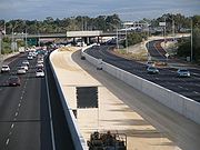
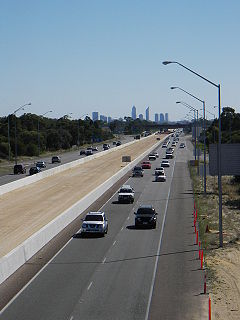
The Kwinana Freeway is a major arterial road in Perth
, Western Australia
, linking Perth
with the southern suburbs and then further on towards Mandurah
, a distance of 78 km (48.5 mi). It has a speed limit of 100 km/h (62.1 mph), except in central Perth (80 km/h (49.7 mph)) and south of Lakes Road (110 km/h (68.4 mph)). Like all Western Australian freeways, the minimum allowed speed, where safe, is always 20 km/h (12.4 mph) less than the maximum speed limit. The freeway, like the Mitchell Freeway
, has been allocated State Route 2 and is part of National Highway 1
between Canning Highway
and Leach Highway
.
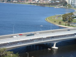
The Kwinana Freeway is a dual carriageway
with five lanes in each direction north of Mill Point Road, and three or four lanes north of Leach Highway
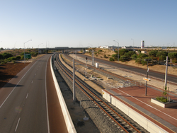
. South of that point, it generally has two lanes in each direction, with sufficient lateral clearance under bridges for additional future lanes. It also acts as part of the boundary for many of Perth's southern suburbs. The Mandurah railway line runs in the freeway median
between the city and the suburb of Mandogalup, where it then deviates to the west towards the city of Rockingham and south to Mandurah.
was opened and a dual carriageway urban road built to Canning Highway. It was upgraded to freeway standard in the 1970s, with the Judd Street bridge being opened in 1976, and the Canning Highway interchange in 1979.
A major southern extension was built between 1979 and 1982 which extended the freeway 7 km (4.3 mi) further south past Leach Highway
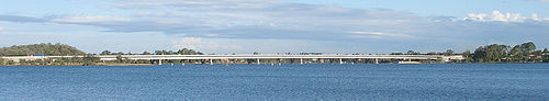
to South Street. This included construction of the Mount Henry Bridge
, which is Western Australia's longest at 660 m (721.8 yd).
 The third stage, opened in 1991, extended the freeway another 9 km (5.6 mi) to Forrest Road (Now Armadale Road/Beeliar Drive).
The fourth stage, opened in 1994, brought the freeway closer to Rockingham
, in the process opening up the then undeveloped southern suburbs in the City of Cockburn
. This extension was not built to freeway standard (though the new road was still named Kwinana Freeway) because of insufficient funding required to build the five necessary interchange bridges. South of Farrington Road, there were traffic light
s (complete with "end of freeway" and "start of freeway" signs) at each intersection.
A fifth stage was completed in 2002, including:
During the afternoon on 13 May 2005, a water pipe burst near the southbound Mill Point Road freeway onramp in South Perth
. This resulted in widespread flooding in the area, submerging the southbound lanes of the freeway, and collapsed the onramp. This caused traffic gridlock
throughout the city and much of the metropolitan area, lasting well into the night. On average it took people over two hours to travel between the Mill Point Road exit in South Perth to Canning Highway in Como along the parallel Labouchere Road.
In mid-2006, the Bus Transitway was closed permanently in order to allow construction of the Mandurah railway line, completed in 2007. After rail services commenced, most freeway bus services ceased, however dedicated on-ramps, off-ramps and short priority lanes were provided for the remaining services between Canning Highway
and Perth.
 Construction of a 32 km (19.9 mi) extension south to Pinjarra Road and the Murray River at South Yunderup was completed in 2009. South of Pinjarra Road construction was also completed on the Forrest Highway, a 38 km (23.6 mi) dual carriageway rural highway formerly known as the "Peel Deviation". The Forrest Highway takes traffic around the Eastern side of the Peel-Harvey Estuary
to join the existing dual carriageway on Old Coast Road at Lake Clifton
. The highway was constructed with the ability to upgrade to freeway standard in the future. The joint freeway and highway construction project was known as the "New Perth Bunbury Highway" during construction until the highway was named.
The freeway and highway will divert traffic around Mandurah cutting traffic in Mandurah and reducing the journey time from Perth to Bunbury, especially during school holidays where families take the time to travel to Western Australia's South-west. The Kwinana Freeway extension and Forrest Highway were opened on 20 September 2009
At the Manning Road interchange there are plans for a southbound on-ramp, but the project is not currently funded and is made more difficult by two blocks of flats that would require demolition.
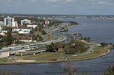
 The North end of Kwinana Freeway begins in the Narrows traffic interchange with Mitchell Freeway
. The interchange is at the North end of the Narrows Bridge. A 32 kilometre extension of the freeway, opened in September 2009, has the Kwinana Freeway terminating at Pinjarra Road to the east of Mandurah.
Perth, Western Australia
Perth is the capital and largest city of the Australian state of Western Australia and the fourth most populous city in Australia. The Perth metropolitan area has an estimated population of almost 1,700,000....
, Western Australia
Western Australia
Western Australia is a state of Australia, occupying the entire western third of the Australian continent. It is bounded by the Indian Ocean to the north and west, the Great Australian Bight and Indian Ocean to the south, the Northern Territory to the north-east and South Australia to the south-east...
, linking Perth
Perth, Western Australia
Perth is the capital and largest city of the Australian state of Western Australia and the fourth most populous city in Australia. The Perth metropolitan area has an estimated population of almost 1,700,000....
with the southern suburbs and then further on towards Mandurah
Mandurah, Western Australia
Mandurah is the second-largest city in Western Australia and is located approximately south of the state capital, Perth.The city attracts a large number of tourists, including many international visitors...
, a distance of 78 km (48.5 mi). It has a speed limit of 100 km/h (62.1 mph), except in central Perth (80 km/h (49.7 mph)) and south of Lakes Road (110 km/h (68.4 mph)). Like all Western Australian freeways, the minimum allowed speed, where safe, is always 20 km/h (12.4 mph) less than the maximum speed limit. The freeway, like the Mitchell Freeway
Mitchell Freeway
Mitchell Freeway is a long freeway in Perth, Western Australia, linking Perth's central business district with its outer northern suburbs. It is allocated Route 2 for its entire length and is named after former state Premier and Governor Sir James Mitchell....
, has been allocated State Route 2 and is part of National Highway 1
Highway 1 (Australia)
Australia's Highway 1 is a network of highways that circumnavigate the Australian continent, joining all mainland state capitals. At a total length of approximately it is the longest national highway in the world, longer than the Trans-Siberian Highway and the Trans-Canada Highway...
between Canning Highway
Canning Highway
Canning Highway is a mostly 4 lane single carriageway major arterial road in Perth, Western Australia. The speed limit is 60 km/h. It is located south of the Swan River and links Perth with Fremantle, running between The Causeway in Victoria Park and Queen Victoria Street in...
and Leach Highway
Leach Highway
Leach Highway is a major dual carriageway arterial road in Perth, Western Australia, which varies between 4 and 6 lanes wide. The speed limit is either 70 or 80 km/h. It is located south of the Swan River and links Fremantle with Kewdale, a distance of ....
.
The Kwinana Freeway is a dual carriageway
Dual carriageway
A dual carriageway is a class of highway with two carriageways for traffic travelling in opposite directions separated by a central reservation...
with five lanes in each direction north of Mill Point Road, and three or four lanes north of Leach Highway
Leach Highway
Leach Highway is a major dual carriageway arterial road in Perth, Western Australia, which varies between 4 and 6 lanes wide. The speed limit is either 70 or 80 km/h. It is located south of the Swan River and links Fremantle with Kewdale, a distance of ....
. South of that point, it generally has two lanes in each direction, with sufficient lateral clearance under bridges for additional future lanes. It also acts as part of the boundary for many of Perth's southern suburbs. The Mandurah railway line runs in the freeway median
Central reservation
On divided roads, such as divided highways or freeways/motorways, the central reservation , median, parkway , median strip or central nature strip is the area which separates opposing lanes of traffic...
between the city and the suburb of Mandogalup, where it then deviates to the west towards the city of Rockingham and south to Mandurah.
History
The first portion of the present Kwinana Freeway was completed in 1959, with a speed set at 50 mph (22.4 m/s) when the Narrows BridgeNarrows Bridge
The Narrows Bridge is a freeway crossing of the Swan River in Perth, Western Australia, at The Narrows between Mill Point and Mount Eliza. Made up of two road bridges and a railway bridge, it connects the Mitchell and Kwinana Freeways, linking the city's northern and southern suburbs...
was opened and a dual carriageway urban road built to Canning Highway. It was upgraded to freeway standard in the 1970s, with the Judd Street bridge being opened in 1976, and the Canning Highway interchange in 1979.
A major southern extension was built between 1979 and 1982 which extended the freeway 7 km (4.3 mi) further south past Leach Highway
Leach Highway
Leach Highway is a major dual carriageway arterial road in Perth, Western Australia, which varies between 4 and 6 lanes wide. The speed limit is either 70 or 80 km/h. It is located south of the Swan River and links Fremantle with Kewdale, a distance of ....
to South Street. This included construction of the Mount Henry Bridge
Mount Henry Bridge
The Mount Henry Bridge carries the Kwinana Freeway and Mandurah railway line over the Canning River in Perth, Western Australia, approximately 10 kilometres south of the Perth central business district. At 660 metres long, it is the longest road bridge in Western Australia...
, which is Western Australia's longest at 660 m (721.8 yd).
The fourth stage, opened in 1994, brought the freeway closer to Rockingham
Rockingham, Western Australia
Rockingham is a suburb and primary centre in Western Australia south-west of the Perth city centre and south of Fremantle. It has a beachside location at Mangles Bay, the southern extremity of Cockburn Sound. To its north stretches the maritime and resource-industry installations of Kwinana and...
, in the process opening up the then undeveloped southern suburbs in the City of Cockburn
Cockburn, Western Australia
The City of Cockburn is a Local Government Area with City status, located in the southern suburbs of the Western Australian capital city of Perth. It is situated about south of Fremantle and about south of Perth's central business district...
. This extension was not built to freeway standard (though the new road was still named Kwinana Freeway) because of insufficient funding required to build the five necessary interchange bridges. South of Farrington Road, there were traffic light
Traffic light
Traffic lights, which may also be known as stoplights, traffic lamps, traffic signals, signal lights, robots or semaphore, are signalling devices positioned at road intersections, pedestrian crossings and other locations to control competing flows of traffic...
s (complete with "end of freeway" and "start of freeway" signs) at each intersection.
A fifth stage was completed in 2002, including:
- a 12 km (7.5 mi) extension to Safety Bay Road, south of Rockingham;
- interchanges at the five intersections previously controlled by traffic lights; and
- the Kwinana Freeway Bus Transitway, comprising
- a two-lane busway between the Esplanade Busport and Canning HighwayCanning HighwayCanning Highway is a mostly 4 lane single carriageway major arterial road in Perth, Western Australia. The speed limit is 60 km/h. It is located south of the Swan River and links Perth with Fremantle, running between The Causeway in Victoria Park and Queen Victoria Street in...
; - a northbound bus lane between Canning HighwayCanning HighwayCanning Highway is a mostly 4 lane single carriageway major arterial road in Perth, Western Australia. The speed limit is 60 km/h. It is located south of the Swan River and links Perth with Fremantle, running between The Causeway in Victoria Park and Queen Victoria Street in...
and Murdoch Park 'n' Ride; and - The Canning Bridge Transfer Station, allowing passengers to transfer between Kwinana Freeway and Canning Highway bus services.
- a two-lane busway between the Esplanade Busport and Canning Highway
During the afternoon on 13 May 2005, a water pipe burst near the southbound Mill Point Road freeway onramp in South Perth
South Perth, Western Australia
South Perth is a residential suburb 3 kilometres south of the central business district of Perth, the capital of Western Australia, which adjoins the southern shore of Perth Water on the Swan River...
. This resulted in widespread flooding in the area, submerging the southbound lanes of the freeway, and collapsed the onramp. This caused traffic gridlock
Gridlock
The term gridlock is defined as "A state of severe road congestion arising when continuous queues of vehicles block an entire network of intersecting streets, bringing traffic in all directions to a complete standstill; a traffic jam of this kind." The term originates from a situation possible in...
throughout the city and much of the metropolitan area, lasting well into the night. On average it took people over two hours to travel between the Mill Point Road exit in South Perth to Canning Highway in Como along the parallel Labouchere Road.
In mid-2006, the Bus Transitway was closed permanently in order to allow construction of the Mandurah railway line, completed in 2007. After rail services commenced, most freeway bus services ceased, however dedicated on-ramps, off-ramps and short priority lanes were provided for the remaining services between Canning Highway
Canning Highway
Canning Highway is a mostly 4 lane single carriageway major arterial road in Perth, Western Australia. The speed limit is 60 km/h. It is located south of the Swan River and links Perth with Fremantle, running between The Causeway in Victoria Park and Queen Victoria Street in...
and Perth.
Peel-Harvey Estuary
The Peel Harvey Estuary is a natural estuary which lies roughly parallel to the coast of Western Australia and south of the town of Mandurah. The strip of land between the Indian Ocean and the estuary carries the Old Coast Road and to the east is the Forrest Highway which is the main thoroughfare...
to join the existing dual carriageway on Old Coast Road at Lake Clifton
Lake Clifton, Western Australia
Lake Clifton is a small town located on the east side of the lake of the same name in the Peel region of Western Australia just off the Old Coast Road, between Mandurah and Bunbury at the north end of the Yalgorup National Park...
. The highway was constructed with the ability to upgrade to freeway standard in the future. The joint freeway and highway construction project was known as the "New Perth Bunbury Highway" during construction until the highway was named.
The freeway and highway will divert traffic around Mandurah cutting traffic in Mandurah and reducing the journey time from Perth to Bunbury, especially during school holidays where families take the time to travel to Western Australia's South-west. The Kwinana Freeway extension and Forrest Highway were opened on 20 September 2009
Future works
Works to widen the freeway between Leach Highway and Roe Highway from two to three lanes in each direction began in early April 2011 and will take approximately 12 months to complete. The $58m project was brought forward to ease increased congestion on this part of the freeway.At the Manning Road interchange there are plans for a southbound on-ramp, but the project is not currently funded and is made more difficult by two blocks of flats that would require demolition.
Exits and interchanges
Mitchell Freeway
Mitchell Freeway is a long freeway in Perth, Western Australia, linking Perth's central business district with its outer northern suburbs. It is allocated Route 2 for its entire length and is named after former state Premier and Governor Sir James Mitchell....
. The interchange is at the North end of the Narrows Bridge. A 32 kilometre extension of the freeway, opened in September 2009, has the Kwinana Freeway terminating at Pinjarra Road to the east of Mandurah.
Kwinana Freeway  |
|||
| Northbound exits | Distance to Perth CBD (km) |
Distance to Mandurah (km) |
Southbound exits |
| End Kwinana Freeway continues as Mitchell Freeway Mitchell Freeway Mitchell Freeway is a long freeway in Perth, Western Australia, linking Perth's central business district with its outer northern suburbs. It is allocated Route 2 for its entire length and is named after former state Premier and Governor Sir James Mitchell.... to Joondalup Joondalup, Western Australia Joondalup is a regional metropolitan city within Perth, Western Australia, approximately north of Perth's central business district.It acts as the primary urban centre in Perth's outer northern suburbs.-History:... |
1 | 75 | Start Kwinana Freeway from Mitchell Freeway Mitchell Freeway Mitchell Freeway is a long freeway in Perth, Western Australia, linking Perth's central business district with its outer northern suburbs. It is allocated Route 2 for its entire length and is named after former state Premier and Governor Sir James Mitchell.... |
| NARROWS BRIDGE | NARROWS BRIDGE | ||
| South Perth South Perth, Western Australia South Perth is a residential suburb 3 kilometres south of the central business district of Perth, the capital of Western Australia, which adjoins the southern shore of Perth Water on the Swan River... Mill Point Road |
2 | 74 | no exit |
| no exit | 3 | 73 | South Perth South Perth, Western Australia South Perth is a residential suburb 3 kilometres south of the central business district of Perth, the capital of Western Australia, which adjoins the southern shore of Perth Water on the Swan River... Mill Point Road |
| no exit | 4 | 72 | South Perth South Perth, Western Australia South Perth is a residential suburb 3 kilometres south of the central business district of Perth, the capital of Western Australia, which adjoins the southern shore of Perth Water on the Swan River... South Terrace |
| continues as |
5.5 | 70.5 | Como Como, Western Australia Como is a suburb of Perth, Western Australia. Its Local Government Area is the City of South Perth. The suburb has a population of 12,423. Canning Highway divides the suburb.-History:... , Fremantle Fremantle, Western Australia Fremantle is a city in Western Australia, located at the mouth of the Swan River. Fremantle Harbour serves as the port of Perth, the state capital. Fremantle was the first area settled by the Swan River colonists in 1829... Canning Highway Canning Highway Canning Highway is a mostly 4 lane single carriageway major arterial road in Perth, Western Australia. The speed limit is 60 km/h. It is located south of the Swan River and links Perth with Fremantle, running between The Causeway in Victoria Park and Queen Victoria Street in...    |
| Fremantle Fremantle, Western Australia Fremantle is a city in Western Australia, located at the mouth of the Swan River. Fremantle Harbour serves as the port of Perth, the state capital. Fremantle was the first area settled by the Swan River colonists in 1829... , Como Como, Western Australia Como is a suburb of Perth, Western Australia. Its Local Government Area is the City of South Perth. The suburb has a population of 12,423. Canning Highway divides the suburb.-History:... Canning Highway Canning Highway Canning Highway is a mostly 4 lane single carriageway major arterial road in Perth, Western Australia. The speed limit is 60 km/h. It is located south of the Swan River and links Perth with Fremantle, running between The Causeway in Victoria Park and Queen Victoria Street in... |
start |
||
| no exit | 6 | 70 | Manning Manning, Western Australia Manning is a suburb of Perth, Western Australia.The land was originally purchased by Henry Manning in 1856, with Manning's grandson, John Daniel Manning having a dairy farm in the area... , Curtin University, Cannington Cannington, Western Australia Cannington is a southern suburb of Perth, Western Australia. Its Local Government Area is the City of Canning.-History:Cannington's name derives from the Canning River, which forms part of the southwestern boundary of the suburb... Manning Road  |
| MOUNT HENRY BRIDGE Mount Henry Bridge The Mount Henry Bridge carries the Kwinana Freeway and Mandurah railway line over the Canning River in Perth, Western Australia, approximately 10 kilometres south of the Perth central business district. At 660 metres long, it is the longest road bridge in Western Australia... |
8 | 68 | MOUNT HENRY BRIDGE Mount Henry Bridge The Mount Henry Bridge carries the Kwinana Freeway and Mandurah railway line over the Canning River in Perth, Western Australia, approximately 10 kilometres south of the Perth central business district. At 660 metres long, it is the longest road bridge in Western Australia... |
| no exit | 9 | 67 | Mount Pleasant Mount Pleasant, Western Australia Mount Pleasant is a suburb of Perth, Western Australia, located within the City of Melville on the Canning River.Mount Pleasant hosts the Head of the River Rowing event, as part of the Public Schools Association, an elite boys schools association in Perth.... Cranford Avenue |
| start |
10 | 66 | Riverton Riverton, Western Australia Riverton is a suburb of Perth in Western Australia.-Location:Riverton is situated about 14 km or 15 minutes from Perth. The Canning River makes some of its north eastern boundary. It is part of the City of Canning, situated south east of the Swan River... , Cannington Cannington, Western Australia Cannington is a southern suburb of Perth, Western Australia. Its Local Government Area is the City of Canning.-History:Cannington's name derives from the Canning River, which forms part of the southwestern boundary of the suburb... , Kewdale Kewdale, Western Australia Kewdale is a suburb of Perth, Western Australia, located within the City of Belmont. Kew Street was one of the first roads in this district, hence the naming of the suburb.... Leach Highway Leach Highway Leach Highway is a major dual carriageway arterial road in Perth, Western Australia, which varies between 4 and 6 lanes wide. The speed limit is either 70 or 80 km/h. It is located south of the Swan River and links Fremantle with Kewdale, a distance of ....  |
| Fremantle Fremantle, Western Australia Fremantle is a city in Western Australia, located at the mouth of the Swan River. Fremantle Harbour serves as the port of Perth, the state capital. Fremantle was the first area settled by the Swan River colonists in 1829... , Booragoon Booragoon, Western Australia Booragoon is a suburb of Perth, Western Australia located within the City of Melville.Booragoon is the aboriginal name for the lower reaches of the Canning River.... Leach Highway Leach Highway Leach Highway is a major dual carriageway arterial road in Perth, Western Australia, which varies between 4 and 6 lanes wide. The speed limit is either 70 or 80 km/h. It is located south of the Swan River and links Fremantle with Kewdale, a distance of .... |
continues as |
||
| Fremantle Fremantle, Western Australia Fremantle is a city in Western Australia, located at the mouth of the Swan River. Fremantle Harbour serves as the port of Perth, the state capital. Fremantle was the first area settled by the Swan River colonists in 1829... , Kardinya Kardinya, Western Australia Kardinya is a suburb of Perth, Western Australia, located within the City of Melville. The suburb is home to under 10,000 people, including international students and locals rent residences due to its proximity to Murdoch University and Murdoch College.... , Murdoch University Murdoch University Murdoch University is a public university based in Perth, Australia. It began operations as the state's second university in 1973, and accepted its first students in 1975... South Street  |
12 | 64 | Willetton Willetton, Western Australia Willetton is a large southern suburb of Perth, Western Australia. Its Local Government Area is the City of Canning.-History:Willetton's name derives from Henry Willett of Willett & Co, who was granted Canning Location 21 and settled in the area in June 1832... , Canning Vale Canning Vale, Western Australia Canning Vale is a large southern suburb of Perth, and is located 20 km from the Perth CBD. Its Local Government Areas are the City of Canning and the City of Gosnells .-History:... South Street |
| no exit | 13.5 | 62.5 | Leeming Leeming, Western Australia Leeming is a southern suburb of Perth, Western Australia. It is divided between the tree Local Government Areas of the City of Melville, the City of Cockburn and the City of Canning... , North Lake North Lake, Western Australia North Lake is a suburb south of the central business district of Perth, the capital of Western Australia, and from the Indian Ocean. The suburb is located within the City of Cockburn local government area.-History:... Farrington Road |
| Canning Vale Canning Vale, Western Australia Canning Vale is a large southern suburb of Perth, and is located 20 km from the Perth CBD. Its Local Government Areas are the City of Canning and the City of Gosnells .-History:... , Forrestfield Forrestfield, Western Australia Forrestfield is a suburb of the Shire of Kalamunda in Western Australia. It lies 15 km to the southeast of Perth at the base of the Darling Scarp and the Southern border of the International Airport. There is authority to suggest it is named after Western Australia's first premier, John Forrest... , Midland Midland, Western Australia Midland is a suburb in the Perth, Western Australia metropolitan area, as well as the regional centre for the City of Swan local government area that covers the Swan Valley and parts of the Darling Scarp to the east. It is situated at the intersection of Great Eastern Highway and Great Northern... Roe Highway Roe Highway Roe Highway is a limited access dual carriageway in Western Australia. It links Great Northern Highway and Middle Swan Road with Kwinana Freeway. It is one of the key heavy vehicle routes in the Perth metropolitan area. Aside from intersections, the speed limit is 100 km/h for most of its length...  |
14 | 62 | Canning Vale Canning Vale, Western Australia Canning Vale is a large southern suburb of Perth, and is located 20 km from the Perth CBD. Its Local Government Areas are the City of Canning and the City of Gosnells .-History:... , Forrestfield Forrestfield, Western Australia Forrestfield is a suburb of the Shire of Kalamunda in Western Australia. It lies 15 km to the southeast of Perth at the base of the Darling Scarp and the Southern border of the International Airport. There is authority to suggest it is named after Western Australia's first premier, John Forrest... , Midland Midland, Western Australia Midland is a suburb in the Perth, Western Australia metropolitan area, as well as the regional centre for the City of Swan local government area that covers the Swan Valley and parts of the Darling Scarp to the east. It is situated at the intersection of Great Eastern Highway and Great Northern... Roe Highway Roe Highway Roe Highway is a limited access dual carriageway in Western Australia. It links Great Northern Highway and Middle Swan Road with Kwinana Freeway. It is one of the key heavy vehicle routes in the Perth metropolitan area. Aside from intersections, the speed limit is 100 km/h for most of its length... |
| South Lake South Lake, Western Australia South Lake is a suburb of Perth, Western Australia, located within the City of Cockburn.-History:Name proposed by Taylor Woodrow Homes Builders Pty. Ltd and the City of Cockburn in March 1982 after a previous suggestion had been rejected because of duplication. Situated to the south of North Lake,... , Jandakot Berrigan Drive |
17 | 59 | Jandakot, South Lake South Lake, Western Australia South Lake is a suburb of Perth, Western Australia, located within the City of Cockburn.-History:Name proposed by Taylor Woodrow Homes Builders Pty. Ltd and the City of Cockburn in March 1982 after a previous suggestion had been rejected because of duplication. Situated to the south of North Lake,... Berrigan Drive |
| Yangebup Yangebup, Western Australia Yangebup is a southern suburb of Perth, Western Australia. Located in the City of Cockburn, the suburb takes its name from the nearby Yangebup Lake.- History :... , Cockburn Central Cockburn Central, Western Australia Cockburn Central is a suburb of Perth, the capital city of Western Australia, and is located south of Perth's central business district along the Kwinana Freeway. Its Local Government Area is the City of Cockburn, and it is intended by the Government to serve as a regional centre for the area... Beeliar Drive  Armadale Road Armadale Road, Perth Armadale Road is a major road in the south and south east of the Perth Metropolitan Area. It serves three purposes: firstly, providing a main route from Armadale to Fremantle; secondly, connecting Armadale to the Kwinana Freeway; and thirdly, since 2005, connecting it to the Tonkin Highway which... |
19 | 57 | Harrisdale Harrisdale, Western Australia Harrisdale is a southeastern suburb of Perth, Western Australia and is one of the western suburbs of the City of Armadale. It was gazetted in 2007... , Armadale Armadale, Western Australia Armadale is a suburb within the City of Armadale, located on the south-eastern edge of Perth's metropolitan area. The major junction of the South Western and Albany Highways, which connect Perth with the South West and Great Southern regions of Western Australia respectively, is located within the... Armadale Road Armadale Road, Perth Armadale Road is a major road in the south and south east of the Perth Metropolitan Area. It serves three purposes: firstly, providing a main route from Armadale to Fremantle; secondly, connecting Armadale to the Kwinana Freeway; and thirdly, since 2005, connecting it to the Tonkin Highway which... Beeliar Drive |
| Success Success, Western Australia Success is a southern suburb of Perth, Western Australia, located within the City of Cockburn.The name Success comes from Captain James Stirling's ship HMS Success.... , Atwell Atwell, Western Australia Atwell is a suburb within the metropolitan area of Perth, Western Australia, Western Australia, situated south of Perth City, and located in the City of Cockburn local government area.-Geography:... Russell Road Gibbs Road |
22 | 54 | Atwell Atwell, Western Australia Atwell is a suburb within the metropolitan area of Perth, Western Australia, Western Australia, situated south of Perth City, and located in the City of Cockburn local government area.-Geography:... , Success Success, Western Australia Success is a southern suburb of Perth, Western Australia, located within the City of Cockburn.The name Success comes from Captain James Stirling's ship HMS Success.... Gibbs Road Russell Road |
| Hammond Park Hammond Park, Western Australia Hammond Park is a southern suburb of Perth, Western Australia, located within the City of Cockburn. Hammond Park was previously part of Banjup, and the suburb created in March 2002.... , Aubin Grove Aubin Grove, Western Australia Aubin Grove is a suburb of Perth, Western Australia, located within the City of Cockburn. The suburb was approved in 2003.Aubin Grove is a new suburb in the City of Cockburn which was formerly part of the rural locality of Banjup. It is named after Henry John Aubin who leased agricultural land in... Rowley Road |
24 | 52 | Aubin Grove Aubin Grove, Western Australia Aubin Grove is a suburb of Perth, Western Australia, located within the City of Cockburn. The suburb was approved in 2003.Aubin Grove is a new suburb in the City of Cockburn which was formerly part of the rural locality of Banjup. It is named after Henry John Aubin who leased agricultural land in... , Hammond Park Hammond Park, Western Australia Hammond Park is a southern suburb of Perth, Western Australia, located within the City of Cockburn. Hammond Park was previously part of Banjup, and the suburb created in March 2002.... Rowley Road |
| Mandogalup Mandogalup, Western Australia Mandogalup is a suburb of Perth, Western Australia, located within the Town of Kwinana. Its postcode is 6167.The area of this suburb was originally referred to as "7 Mile Camp", but when a townsite was declared here in 1923 it was named "Balmanup". Lake Balmanup was an alternative name for... , Oakford Oakford, Western Australia Oakford is an outer suburb of Perth, Western Australia, within the Shire of Serpentine-Jarrahdale. The suburb was named in 1982, taking its name from a townsite briefly declared in the area in 1926.... Anketell Road |
29 | 47 | Oakford Oakford, Western Australia Oakford is an outer suburb of Perth, Western Australia, within the Shire of Serpentine-Jarrahdale. The suburb was named in 1982, taking its name from a townsite briefly declared in the area in 1926.... , Mandogalup Mandogalup, Western Australia Mandogalup is a suburb of Perth, Western Australia, located within the Town of Kwinana. Its postcode is 6167.The area of this suburb was originally referred to as "7 Mile Camp", but when a townsite was declared here in 1923 it was named "Balmanup". Lake Balmanup was an alternative name for... Anketell Road |
| RAIL LINE | 30 | 45 | |
| Kwinana Kwinana, Western Australia The Town of Kwinana is a Local Government Area of Western Australia. It covers an area of approximately 118 square kilometres in metropolitan Perth, and lies about 38 km south of Perth's central business district, via the Kwinana Freeway... , Byford Byford, Western Australia Byford is a suburb on the southeastern edge of Perth, Australia, originally founded as the townsite of Beenup in 1906.Beenup took its name from the railway siding there, a corruption of the Aboriginal name of nearby Beenyup Brook... Thomas Road Thomas Road, Perth Thomas Road is a major west-east road in the far southern suburbs of Perth, Western Australia, connecting Rockingham Road in Kwinana's industrial area with Kwinana's urban area, before bridging Perth's agricultural fringe to meet the South Western Highway in Byford, just south of Armadale...  |
30.5 | 45.5 | Kwinana Kwinana, Western Australia The Town of Kwinana is a Local Government Area of Western Australia. It covers an area of approximately 118 square kilometres in metropolitan Perth, and lies about 38 km south of Perth's central business district, via the Kwinana Freeway... , Byford Byford, Western Australia Byford is a suburb on the southeastern edge of Perth, Australia, originally founded as the townsite of Beenup in 1906.Beenup took its name from the railway siding there, a corruption of the Aboriginal name of nearby Beenyup Brook... Thomas Road Thomas Road, Perth Thomas Road is a major west-east road in the far southern suburbs of Perth, Western Australia, connecting Rockingham Road in Kwinana's industrial area with Kwinana's urban area, before bridging Perth's agricultural fringe to meet the South Western Highway in Byford, just south of Armadale... |
| Kwinana Kwinana, Western Australia The Town of Kwinana is a Local Government Area of Western Australia. It covers an area of approximately 118 square kilometres in metropolitan Perth, and lies about 38 km south of Perth's central business district, via the Kwinana Freeway... , Wellard Wellard, Western Australia Wellard is a suburb of Perth, Western Australia, located within the Town of Kwinana.The suburb name commemorates an early settler, John Wellard, who in 1860 owned Serpentine Farm about 7.5 km southeast of the suburb. A government townsite with his name was declared in 1923 but cancelled in... Mortimer Road Bertram Road |
33.5 | 42.5 | Wellard Wellard, Western Australia Wellard is a suburb of Perth, Western Australia, located within the Town of Kwinana.The suburb name commemorates an early settler, John Wellard, who in 1860 owned Serpentine Farm about 7.5 km southeast of the suburb. A government townsite with his name was declared in 1923 but cancelled in... , Kwinana Kwinana, Western Australia The Town of Kwinana is a Local Government Area of Western Australia. It covers an area of approximately 118 square kilometres in metropolitan Perth, and lies about 38 km south of Perth's central business district, via the Kwinana Freeway... Bertram Road Mortimer Road |
| RAIL LINE | 36 | 40 | RAIL LINE |
| Baldivis Baldivis, Western Australia Baldivis is a semi-rural residential suburb south of the central business district of Perth, the capital of Western Australia, and southeast of the regional centre of Rockingham... , Mundijong Mundijong, Western Australia Mundijong is an outer suburb of the Western Australian capital city of Perth. Originally named Jarrahdale Junction, it was at the junction of the Rockingham-Jarrahdale line and the government line from Perth to Bunbury which was built in 1893... Mundijong Road  |
38 | 38 | Mundijong Mundijong, Western Australia Mundijong is an outer suburb of the Western Australian capital city of Perth. Originally named Jarrahdale Junction, it was at the junction of the Rockingham-Jarrahdale line and the government line from Perth to Bunbury which was built in 1893... , Baldivis Baldivis, Western Australia Baldivis is a semi-rural residential suburb south of the central business district of Perth, the capital of Western Australia, and southeast of the regional centre of Rockingham... Mundijong Road |
| Baldivis Baldivis, Western Australia Baldivis is a semi-rural residential suburb south of the central business district of Perth, the capital of Western Australia, and southeast of the regional centre of Rockingham... , Rockingham Rockingham, Western Australia Rockingham is a suburb and primary centre in Western Australia south-west of the Perth city centre and south of Fremantle. It has a beachside location at Mangles Bay, the southern extremity of Cockburn Sound. To its north stretches the maritime and resource-industry installations of Kwinana and... Safety Bay Road Safety Bay Road, Rockingham Safety Bay Road is an east-west metropolitan road located in the City of Rockingham, about south of Perth, Western Australia. The road starts in Rockingham's coastal suburbs, and extends past Ennis Avenue and Warnbro railway station to the newer suburban estates at Baldivis, before ending just...  Folly Road |
43 | 33 | Baldivis Baldivis, Western Australia Baldivis is a semi-rural residential suburb south of the central business district of Perth, the capital of Western Australia, and southeast of the regional centre of Rockingham... , Rockingham Rockingham, Western Australia Rockingham is a suburb and primary centre in Western Australia south-west of the Perth city centre and south of Fremantle. It has a beachside location at Mangles Bay, the southern extremity of Cockburn Sound. To its north stretches the maritime and resource-industry installations of Kwinana and... Folly Road Safety Bay Road Safety Bay Road, Rockingham Safety Bay Road is an east-west metropolitan road located in the City of Rockingham, about south of Perth, Western Australia. The road starts in Rockingham's coastal suburbs, and extends past Ennis Avenue and Warnbro railway station to the newer suburban estates at Baldivis, before ending just... |
| Port Kennedy Port Kennedy, Western Australia Port Kennedy is an outer southern suburb of Perth, the capital city of Western Australia, located within the City of Rockingham.Port Kennedy is built on Becher Point and because of its geomorphological history it is home to an unusual wetland formation, called the Becher Wetland Suite... , Serpentine Serpentine, Western Australia Serpentine is a town located south-southeast of Perth, the capital of Western Australia, and 7 km south of Mundijong. Serpentine is located on the South Western Railway between Perth and Bunbury, and was one of the original stations when the line was opened in 1893... Karnup Road |
48 | 28 | Serpentine Serpentine, Western Australia Serpentine is a town located south-southeast of Perth, the capital of Western Australia, and 7 km south of Mundijong. Serpentine is located on the South Western Railway between Perth and Bunbury, and was one of the original stations when the line was opened in 1893... , Port Kennedy Port Kennedy, Western Australia Port Kennedy is an outer southern suburb of Perth, the capital city of Western Australia, located within the City of Rockingham.Port Kennedy is built on Becher Point and because of its geomorphological history it is home to an unusual wetland formation, called the Becher Wetland Suite... Karnup Road |
| Karnup Karnup, Western Australia Karnup is an outer southern suburb of Perth, the capital city of Western Australia, located within the City of Rockingham.... , Golden Bay Golden Bay, Western Australia Golden Bay is an outer southern suburb of Perth, the capital city of Western Australia, located within the City of Rockingham.Originally known as Peelhurst the locality name was officially changed in 1985.... Paganoni Road Vine Road |
55 | 16 | Karnup Karnup, Western Australia Karnup is an outer southern suburb of Perth, the capital city of Western Australia, located within the City of Rockingham.... , Golden Bay Golden Bay, Western Australia Golden Bay is an outer southern suburb of Perth, the capital city of Western Australia, located within the City of Rockingham.Originally known as Peelhurst the locality name was officially changed in 1985.... Vine Road Paganoni Road |
| Mandurah, Stake Hill Stake Hill, Western Australia Stake Hill is a northeastern rural residential suburb of Mandurah, Western Australia. Its Local Government Area is the Shire of Murray. At the 2006 census, Stake Hill had a population of 670.-History:... Mandjoogoordap Drive Mandjoogoordap Drive Mandjoogoordap Drive, meaning "meeting place of the heart" in the indigenous Noongar language, is a dual carriageway road which links the Western Australian city of Mandurah to the Kwinana Freeway. It was officially opened on the 7th October 2010...  Lymon Road |
60 | 13 | Stake Hill Stake Hill, Western Australia Stake Hill is a northeastern rural residential suburb of Mandurah, Western Australia. Its Local Government Area is the Shire of Murray. At the 2006 census, Stake Hill had a population of 670.-History:... , Mandurah Lymon Road Mandjoogoordap Drive Mandjoogoordap Drive Mandjoogoordap Drive, meaning "meeting place of the heart" in the indigenous Noongar language, is a dual carriageway road which links the Western Australian city of Mandurah to the Kwinana Freeway. It was officially opened on the 7th October 2010... |
| SERPENTINE RIVER BRIDGE Serpentine River (Western Australia) The Serpentine River is a river in the South West region of Western Australia.The river rises in the Darling Scarp below Bowerling Hill and flows westward crossing Albany Highway North of North Bannister. The river continues North West through the Youarling State Forest then the Serpentine National... |
-- | -- | SERPENTINE RIVER BRIDGE Serpentine River (Western Australia) The Serpentine River is a river in the South West region of Western Australia.The river rises in the Darling Scarp below Bowerling Hill and flows westward crossing Albany Highway North of North Bannister. The river continues North West through the Youarling State Forest then the Serpentine National... |
| Greenfields Greenfields, Western Australia Greenfields is a suburb of Mandurah, located east of Mandurah's central area. It includes several aged care residences and a large recreation oval and centre.... , North Dandalup North Dandalup, Western Australia North Dandalup is a small town in the Peel region of Western Australia along the South Western Highway between Serpentine and Pinjarra. Its local government area is the Shire of Murray... Lakes Road |
-- | -- | North Dandalup North Dandalup, Western Australia North Dandalup is a small town in the Peel region of Western Australia along the South Western Highway between Serpentine and Pinjarra. Its local government area is the Shire of Murray... , Greenfields Greenfields, Western Australia Greenfields is a suburb of Mandurah, located east of Mandurah's central area. It includes several aged care residences and a large recreation oval and centre.... Lakes Road |
| Pinjarra Pinjarra, Western Australia Pinjarra is a town in the Peel region of Western Australia along the South Western Highway, from the state capital, Perth and south-east of the coastal city of Mandurah. Its local government area is the Shire of Murray. At the 2006 census, Pinjarra had a population of 3,279.Pinjarra is an area... , Mandurah Pinjarra Road Pinjarra Road Pinjarra Road is a major west-east road connecting the two major centres of the Peel Region, Mandurah and Pinjarra. Mostly a dual carriageway, it also forms the termini of both the Kwinana Freeway and Forrest Highway.-Major intersections:... |
-- | -- | Mandurah, Pinjarra Pinjarra, Western Australia Pinjarra is a town in the Peel region of Western Australia along the South Western Highway, from the state capital, Perth and south-east of the coastal city of Mandurah. Its local government area is the Shire of Murray. At the 2006 census, Pinjarra had a population of 3,279.Pinjarra is an area... Pinjarra Road Pinjarra Road Pinjarra Road is a major west-east road connecting the two major centres of the Peel Region, Mandurah and Pinjarra. Mostly a dual carriageway, it also forms the termini of both the Kwinana Freeway and Forrest Highway.-Major intersections:... |
| MURRAY RIVER BRIDGE Murray River (Western Australia) The Murray River is a river in the southwest of Western Australia which played a significant part in the expansion of Aboriginal settlement in the area south of Perth after the arrival of British settlers at the Swan River Colony in 1829.... |
-- | -- | MURRAY RIVER BRIDGE Murray River (Western Australia) The Murray River is a river in the southwest of Western Australia which played a significant part in the expansion of Aboriginal settlement in the area south of Perth after the arrival of British settlers at the Swan River Colony in 1829.... |
| CONTINUES AS Forrest Highway to Waroona Waroona, Western Australia Waroona is a town located in the Peel region of Western Australia along the South Western Highway, between Pinjarra and Harvey. The town is the seat of the Shire of Waroona. At the 2006 census, Waroona had a population of 1,864.-History:... / Bunbury Bunbury, Western Australia The port city of Bunbury is the third largest city in Western Australia after the State Capital Perth and Mandurah. It is situated south of Perth's central business district... |
|||
See also
- Freeways in AustraliaFreeways in AustraliaThis is a list of freeways and motorways in Australia, sorted by states and territories and their corresponding routes. This list includes toll roads such as the CityLink freeway system in Melbourne. This list has over 70 entries...
- Freeways in Western Australia
- List of major roads in Perth, Western Australia
- Mitchell FreewayMitchell FreewayMitchell Freeway is a long freeway in Perth, Western Australia, linking Perth's central business district with its outer northern suburbs. It is allocated Route 2 for its entire length and is named after former state Premier and Governor Sir James Mitchell....
External links
- http://www.southperth.wa.gov.au/meetings/docs/2001/May/Council/attachment_9.4.3_.pdf
- (Main Roads Department, Western Australia)
- (Southern Gateway Alliance - Constructing the Freeway and the "New Perth Bunbury Highway")
- (New name for Mandurah Entrance Road)
- Skyview WA Maps
- Metropolitan Traffic Flows, Appendix A: Dates of Major Changes to the Road Network