
Bussell Highway
Encyclopedia
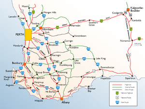
Bussell Highway is a generally north-south highway in the South West of Western Australia
. The highway links the city of Bunbury
with the town of Augusta
and is approximately 150 km in length. The highway is signed State Route 10, except in Busselton
where the construction of the Busselton Bypass in 2001 resulted in this stretch being changed to Alternate State Route 10 with the Bypass signed State Route 10.
The highway is sealed dual carriageway
from Bunbury to Capel
and in the town of Busselton
; and is single carriageway from Capel to Busselton and from Vasse
to Augusta with regular overtaking lanes.
, some of the region's first settlers. It was built in 1894 by M.C. Davies, a timber miller operating from Karridale
to provide better access to Vasse and beyond, linking to the existing road to Bunbury
. The tender had been let to Davies by the State government under John Forrest
.
, Mandurah
, Harvey
and Collie
.
It exits Bunbury as a sealed dual carriageway
, bypassing the town of Capel
before becoming a single carriageway to Busselton
. At a large roundabout, it intersects with the Busselton Bypass and changes name to Causeway Road, then turns left into Albert Street in Busselton's CBD
. After one block it reverts to Bussell Highway, proceeding for 9 km as a dual carriageway
through Busselton's western suburbs before turning left at Abbey.
The road then proceeds as a single carriageway with regular overtaking lanes to Augusta
through small dairy and crop farms, orchards and wineries - the only slow point on this entire journey is when it becomes the main street of the popular tourist and seachange town of Margaret River
.
The highway ends at the entrance to Augusta, but continues as Blackwood Avenue through the town and then Leeuwin Road beyond it for 9 km before reaching Cape Leeuwin
, the southwestern tip of Western Australia
.
Western Australia
Western Australia is a state of Australia, occupying the entire western third of the Australian continent. It is bounded by the Indian Ocean to the north and west, the Great Australian Bight and Indian Ocean to the south, the Northern Territory to the north-east and South Australia to the south-east...
. The highway links the city of Bunbury
Bunbury, Western Australia
The port city of Bunbury is the third largest city in Western Australia after the State Capital Perth and Mandurah. It is situated south of Perth's central business district...
with the town of Augusta
Augusta, Western Australia
Augusta is a town on the south-west coast of Western Australia, where the Blackwood River emerges into Flinders Bay. It is the nearest town to Cape Leeuwin, on the farthest south-west corner of the Australian continent. In the 2001 census it had a population of 1,694; by 2006 the population of...
and is approximately 150 km in length. The highway is signed State Route 10, except in Busselton
Busselton, Western Australia
-Growth and development:According to the Australian Bureau of Statistics the Shire had a permanent resident population of 25,950 in 2004 with the town of Busselton accounting for 67% or 17,400 of the total. The Shire's permanent population is expected to continue to increase significantly to...
where the construction of the Busselton Bypass in 2001 resulted in this stretch being changed to Alternate State Route 10 with the Bypass signed State Route 10.
The highway is sealed dual carriageway
Dual carriageway
A dual carriageway is a class of highway with two carriageways for traffic travelling in opposite directions separated by a central reservation...
from Bunbury to Capel
Capel, Western Australia
Capel is a town in the South West region of Western Australia, located 212 kilometres south of Perth and midway between Bunbury and Busselton....
and in the town of Busselton
Busselton, Western Australia
-Growth and development:According to the Australian Bureau of Statistics the Shire had a permanent resident population of 25,950 in 2004 with the town of Busselton accounting for 67% or 17,400 of the total. The Shire's permanent population is expected to continue to increase significantly to...
; and is single carriageway from Capel to Busselton and from Vasse
Vasse, Western Australia
Vasse is a town in the South West region of Western Australia, west of the town of Busselton and southwest of Perth. Its Local Government Area is the Shire of Busselton...
to Augusta with regular overtaking lanes.
History
Bussell Highway was named after the Bussell familyBussell family
The Bussell family were a family of early settlers in colonial Western Australia. Four members of the Bussell family emigrated from England to Western Australia in 1831, with more members following in the next few years...
, some of the region's first settlers. It was built in 1894 by M.C. Davies, a timber miller operating from Karridale
Karridale, Western Australia
Karridale is a small township in the south-west of Western Australia. Its postcode is 6288 and is located just north of Augusta and south of Margaret River between Caves Road and Bussell Highway. A newer township was built a short distance north east of the original Old Karridale following fires...
to provide better access to Vasse and beyond, linking to the existing road to Bunbury
Bunbury, Western Australia
The port city of Bunbury is the third largest city in Western Australia after the State Capital Perth and Mandurah. It is situated south of Perth's central business district...
. The tender had been let to Davies by the State government under John Forrest
John Forrest
Sir John Forrest GCMG was an Australian explorer, the first Premier of Western Australia and a cabinet minister in Australia's first federal parliament....
.
Description
Departing Bunbury, the highway commences at the intersection of Blair Street and Parade Road outside the Bunbury Racecourse in Carey Park. After about 500m, it intersects at a large roundabout with Bunbury's ring road, Robertson Drive, connecting the highway to main routes to PerthPerth, Western Australia
Perth is the capital and largest city of the Australian state of Western Australia and the fourth most populous city in Australia. The Perth metropolitan area has an estimated population of almost 1,700,000....
, Mandurah
Mandurah, Western Australia
Mandurah is the second-largest city in Western Australia and is located approximately south of the state capital, Perth.The city attracts a large number of tourists, including many international visitors...
, Harvey
Harvey, Western Australia
Harvey is a town located in the South West of Western Australia along the South Western Highway, 140 km south of Perth, between Pinjarra and Bunbury...
and Collie
Collie, Western Australia
-External links:*...
.
It exits Bunbury as a sealed dual carriageway
Dual carriageway
A dual carriageway is a class of highway with two carriageways for traffic travelling in opposite directions separated by a central reservation...
, bypassing the town of Capel
Capel, Western Australia
Capel is a town in the South West region of Western Australia, located 212 kilometres south of Perth and midway between Bunbury and Busselton....
before becoming a single carriageway to Busselton
Busselton, Western Australia
-Growth and development:According to the Australian Bureau of Statistics the Shire had a permanent resident population of 25,950 in 2004 with the town of Busselton accounting for 67% or 17,400 of the total. The Shire's permanent population is expected to continue to increase significantly to...
. At a large roundabout, it intersects with the Busselton Bypass and changes name to Causeway Road, then turns left into Albert Street in Busselton's CBD
Central business district
A central business district is the commercial and often geographic heart of a city. In North America this part of a city is commonly referred to as "downtown" or "city center"...
. After one block it reverts to Bussell Highway, proceeding for 9 km as a dual carriageway
Dual carriageway
A dual carriageway is a class of highway with two carriageways for traffic travelling in opposite directions separated by a central reservation...
through Busselton's western suburbs before turning left at Abbey.
The road then proceeds as a single carriageway with regular overtaking lanes to Augusta
Augusta, Western Australia
Augusta is a town on the south-west coast of Western Australia, where the Blackwood River emerges into Flinders Bay. It is the nearest town to Cape Leeuwin, on the farthest south-west corner of the Australian continent. In the 2001 census it had a population of 1,694; by 2006 the population of...
through small dairy and crop farms, orchards and wineries - the only slow point on this entire journey is when it becomes the main street of the popular tourist and seachange town of Margaret River
Margaret River, Western Australia
Margaret River is a town in the South West of Western Australia, located in the valley of the eponymous Margaret River, south of Perth, the state capital. Its Local Government Area is the Shire of Augusta-Margaret River....
.
The highway ends at the entrance to Augusta, but continues as Blackwood Avenue through the town and then Leeuwin Road beyond it for 9 km before reaching Cape Leeuwin
Cape Leeuwin
Cape Leeuwin is the most south-westerly mainland point of the Australian Continent, in the state of Western Australia.A few small islands and rocks, the St Alouarn Islands, extend further to the south. The nearest settlement, north of the cape, is Augusta. South-east of Cape Leeuwin, the coast...
, the southwestern tip of Western Australia
Western Australia
Western Australia is a state of Australia, occupying the entire western third of the Australian continent. It is bounded by the Indian Ocean to the north and west, the Great Australian Bight and Indian Ocean to the south, the Northern Territory to the north-east and South Australia to the south-east...
.
Major towns
- Gelorup
- CapelCapel, Western AustraliaCapel is a town in the South West region of Western Australia, located 212 kilometres south of Perth and midway between Bunbury and Busselton....
(bypass) - BusseltonBusselton, Western Australia-Growth and development:According to the Australian Bureau of Statistics the Shire had a permanent resident population of 25,950 in 2004 with the town of Busselton accounting for 67% or 17,400 of the total. The Shire's permanent population is expected to continue to increase significantly to...
- Broadwater
- Carbunup RiverCarbunup River, Western AustraliaCarbunup River is a small town in the South West region of Western Australia. It is situated between Dunsboroughand Margaret River on the banks of the Carbunup River....
- CowaramupCowaramup, Western AustraliaCowaramup is a town in the South West of Western Australia, 12 kilometres north of Margaret River in the Shire of Augusta-Margaret River.-Name:...
- Margaret RiverMargaret River, Western AustraliaMargaret River is a town in the South West of Western Australia, located in the valley of the eponymous Margaret River, south of Perth, the state capital. Its Local Government Area is the Shire of Augusta-Margaret River....
- WitchcliffeWitchcliffe, Western AustraliaWitchcliffe is a small town in the South West region of Western Australia, located a few kilometres south of Margaret River on the Bussell Highway.The name originates from a cave in the area, Witchcliffe cave, that was recorded by a surveyor in 1900...
- KarridaleKarridale, Western AustraliaKarridale is a small township in the south-west of Western Australia. Its postcode is 6288 and is located just north of Augusta and south of Margaret River between Caves Road and Bussell Highway. A newer township was built a short distance north east of the original Old Karridale following fires...
- KudardupKudardup, Western AustraliaKudardup is a locality in the South West region of Western Australia. The locality is in the Shire of Augusta-Margaret River and on the Bussell Highway, south of the state capital, Perth. In March 1961 Kudardup was devastated by bush fires...
- AugustaAugusta, Western AustraliaAugusta is a town on the south-west coast of Western Australia, where the Blackwood River emerges into Flinders Bay. It is the nearest town to Cape Leeuwin, on the farthest south-west corner of the Australian continent. In the 2001 census it had a population of 1,694; by 2006 the population of...
Major intersections
-
 (at Carey Park) Robertson Drive to Old Coast RoadOld Coast RoadOld Coast Road is a Western Australian highway linking Mandurah, WA's second-largest city located 75 km south of Perth, with Bunbury, WA's third-largest city. It is signed as Route 1 for most of its length and is long.-Overview:...
, Australind Bypass and South Western HighwaySouth Western HighwaySouth Western Highway is a highway in the South West region of Western Australia connecting Perth's southeast with Walpole. It is a part of the National Highway 1 network for most of its length... - Washington Avenue to Withers
- Norton Promenade to DalyellupDalyellup, Western AustraliaDalyellup is an outer southern suburb of Bunbury, a city in Western Australia, located within the Shire of Capel local government area. The suburb was established in 1999 when the Department of Housing and Works entered into a joint venture with Satterley Property Group to develop Dalyellup Beach...
- (at Stratham) Boyanup West Road to BoyanupBoyanup, Western AustraliaBoyanup is a town located on the South Western Highway in the South West agricultural region, 195 km south of Perth and 18 km south-east of Bunbury, Western Australia....
- (at Capel) Capel Drive to CapelCapel, Western AustraliaCapel is a town in the South West region of Western Australia, located 212 kilometres south of Perth and midway between Bunbury and Busselton....
; links with Goodwood Road to DonnybrookDonnybrook, Western Australia-Tourism:Donnybrook has many town icons bearing the apple. On the main street, apple-shaped lights line the entrance of the Old Railway Station. These lights have recently been restored. Atop the east Donnybrook hill is a high tower with an apple at the top... - (6 km before Busselton) Sue's Road (southwards through forest and agriculture areas)
- (at Busselton):
-
 (at Busselton) Vasse HighwayVasse HighwayVasse Highway is a Western Australian highway connecting Busselton and the South Western Highway 15 km south of Manjimup. It is long and travels through jarrah and karri hardwood forests for most of its length, with some small agricultural areas and wineries nearby, and forms the main street...
to NannupNannup, Western AustraliaNannup is a town and shire in the South West region of Western Australia, approximately south of Perth on the Blackwood River at the crossroads of Vasse Highway and Brockman Highway, linking Nannup to most of the Lower South West's regional centres...
and PembertonPemberton, Western AustraliaPemberton is a town located in the South West region of Western Australia, named after the early settler Pemberton Walcott. It is the home of the karri tree, the largest tree in Western Australia and the third largest hardwood tree in the world... - Busselton Bypass to VasseVasse, Western AustraliaVasse is a town in the South West region of Western Australia, west of the town of Busselton and southwest of Perth. Its Local Government Area is the Shire of Busselton...
-
- (at Abbey) Caves Road to DunsboroughDunsborough, Western AustraliaDunsborough is a coastal town in the South West of Western Australia, south of Perth on the shores of Geographe Bay.Dunsborough is a popular tourist destination for Western Australians; in 1999 it was voted the state's best tourist destination. During the last decade the town has grown quickly and...
and YallingupYallingup, Western AustraliaYallingup is a town in the South West region of Western Australia, south of Perth. Yallingup is a popular tourist destination because of its beaches and limestone caves, and proximity to Leeuwin-Naturaliste National Park.-History and industry:... - (at Margaret River) Wallcliffe Road to PrevellyPrevelly, Western AustraliaPrevelly is a townsite in the South West region of Western Australia. It is located on the coast at the mouth of Margaret River at the northern end of Calgardup Bay...
- (at Karridale) Brockman HighwayBrockman HighwayBrockman Highway is a highway in Western Australia. A few hours south of Perth, it runs west from Bridgetown via Nannup to Karridale.Nannup is situated at the junction of the Vasse Highway and the Brockman Highway....
to NannupNannup, Western AustraliaNannup is a town and shire in the South West region of Western Australia, approximately south of Perth on the Blackwood River at the crossroads of Vasse Highway and Brockman Highway, linking Nannup to most of the Lower South West's regional centres...
and BridgetownBridgetown, Western Australia-Notable people:*Emily Barker, singer-songwriter*Jon Doust, author and comedian*Robyn McSweeney, politician*Tom O'Dwyer, cricketer*David Reid, politician*Deborah Robertson, novelist and poet-External links:* * * * * * * *...
See also
- Highways in AustraliaHighways in AustraliaThis is a list of highways in Australia, listed alphabetically along with each highway's route number and location. Note that some highways service more than one state or territory.-Route numbering systems:...
- List of highways in Western Australia