
Cannington, Western Australia
Encyclopedia
Cannington is a southern suburb of Perth
, Western Australia
. Its Local Government Area
is the City of Canning.
, which forms part of the southwestern boundary of the suburb. It was first subdivided in 1882, and a railway station was constructed in the 1890s opposite Station Street in (now) East Cannington.
runs through the western part of the suburb.
, first built in 1972 and extensively refurbished and expanded in the 1990s, which includes a Hoyts
cinema complex. Albany Highway
contains a range of shops and small warehouses, as well as the City of Canning council offices. Bentley Hospital is just beyond the northwestern boundary on Mills Street.
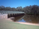
Along the Canning River
is the Canning River Regional Park, which contains walking tracks and picnic facilities as well as the Woodloes Museum, a restored 1874 house built by architect and pioneer Francis Bird. Various sports and leisure facilities, including soccer fields, ten-pin bowling and an indoor athletics centre. The City of Canning showgrounds which include the Cannington raceway which is a greyhound racetrack
, and exhibition buildings.
Cannington Community College
, a public primary and junior high school (K-10), and Sevenoaks Senior College
, a senior secondary college (Years 11 and 12) are located in Cannington.
, a primary route into Perth's CBD
, and lies to the southeast of Leach Highway
and to the northwest of Roe Highway
. Manning Road (State Route 26) provides access to Curtin University of Technology
and Kwinana Freeway
.
Cannington is served by the Cannington Interchange, linking the area to the Perth CBD
. The suburb is also served by buses along Cecil Avenue, Albany Highway
and other routes. All bus services are operated by Swan Transit
.
at both Federal and state elections
.
Perth, Western Australia
Perth is the capital and largest city of the Australian state of Western Australia and the fourth most populous city in Australia. The Perth metropolitan area has an estimated population of almost 1,700,000....
, Western Australia
Western Australia
Western Australia is a state of Australia, occupying the entire western third of the Australian continent. It is bounded by the Indian Ocean to the north and west, the Great Australian Bight and Indian Ocean to the south, the Northern Territory to the north-east and South Australia to the south-east...
. Its Local Government Area
Local Government Areas of Western Australia
The Australian state of Western Australia is divided into 141 local government areas...
is the City of Canning.
History
Cannington's name derives from the Canning RiverCanning River (Western Australia)
The Canning River is a major tributary of the Swan River in south western Western Australia.-Source and route:With headwaters on the Darling Scarp, the Canning meanders through suburbs of Perth on the Swan Coastal Plain, including Cannington, Thornlie, Riverton, Shelley, Rossmoyne and Mount...
, which forms part of the southwestern boundary of the suburb. It was first subdivided in 1882, and a railway station was constructed in the 1890s opposite Station Street in (now) East Cannington.
Waverley
For many years the areas of Cannington, East Cannington and Beckenham were known locally as "Waverley" and many Buildings and Businesses used the name Waverley to designate their locality, such as the Waverley Hotel, the Waverley Drive In Cinema, Waverley Fish n Chips, etc. The origin of the alternative use of Waverley is designated to the Cecil Gibbs who first used it in naming the Waverley Hotel that was a distinctive landmark over many generations. Between 1860 to 1883 William Lacey Gibbs, gradually accumulated most of what is Cannington. His slaughter yards were located near the present day Myer Department Store, Westfield. His brother built the 'Cecil/Waverley' Hotel on the corner of Cecil Road and Albany Highway (Carden, 1968). The hotel was altered many times over the years and was recently demolished for widening of the Albany Highway.Geography
Cannington is bounded by Nicholson Road to the south-east, the Armadale railway line to the northeast, Mills and Burton Streets to the northwest, and Fleming Avenue and the Canning River to the southwest. Albany HighwayAlbany Highway
Albany Highway is a generally northwest-southeast highway in the south of Western Australia which links the state's capital Perth with its oldest settlement, Albany. The highway is approximately in length, is designated State Route 30 and separates Western Australia's Great Southern region from...
runs through the western part of the suburb.
Facilities
Cannington contains one of the Perth metropolitan area's largest shopping complexes, Westfield CarouselWestfield Carousel
Westfield Carousel is a major shopping centre, owned by the Westfield Group and located in Cannington, a suburb of Perth. It is located approximately 12 kilometres from Perth on the Albany Highway, and approximately 600 metres from Cannington Train Station...
, first built in 1972 and extensively refurbished and expanded in the 1990s, which includes a Hoyts
Hoyts
The Hoyts Group is an Australian company consisting of Hoyts Exhibition, Hoyts Distribution and Val Morgan.Hoyts Exhibition manages 450 screens across 40 Australian and 10 New Zealand cinema complexes; making it Australia's second largest cinema chain. Val Morgan, the cinema advertising arm of the...
cinema complex. Albany Highway
Albany Highway
Albany Highway is a generally northwest-southeast highway in the south of Western Australia which links the state's capital Perth with its oldest settlement, Albany. The highway is approximately in length, is designated State Route 30 and separates Western Australia's Great Southern region from...
contains a range of shops and small warehouses, as well as the City of Canning council offices. Bentley Hospital is just beyond the northwestern boundary on Mills Street.
Along the Canning River
Canning River (Western Australia)
The Canning River is a major tributary of the Swan River in south western Western Australia.-Source and route:With headwaters on the Darling Scarp, the Canning meanders through suburbs of Perth on the Swan Coastal Plain, including Cannington, Thornlie, Riverton, Shelley, Rossmoyne and Mount...
is the Canning River Regional Park, which contains walking tracks and picnic facilities as well as the Woodloes Museum, a restored 1874 house built by architect and pioneer Francis Bird. Various sports and leisure facilities, including soccer fields, ten-pin bowling and an indoor athletics centre. The City of Canning showgrounds which include the Cannington raceway which is a greyhound racetrack
Greyhound racing
Greyhound racing is the sport of racing greyhounds. The dogs chase a lure on a track until they arrive at the finish line. The one that arrives first is the winner....
, and exhibition buildings.
Cannington Community College
Cannington Community College
Cannington Community College is an public, co-educational K-10 school in Western Australia. The school is located on Wharf Street in the suburb of Cannington....
, a public primary and junior high school (K-10), and Sevenoaks Senior College
Sevenoaks Senior College
Sevenoaks Senior College is a comprehensive public senior high school located in Cannington, southeast of Perth, Western Australia, immediately adjacent to the Cannington railway station...
, a senior secondary college (Years 11 and 12) are located in Cannington.
Transport
Cannington is on Albany HighwayAlbany Highway
Albany Highway is a generally northwest-southeast highway in the south of Western Australia which links the state's capital Perth with its oldest settlement, Albany. The highway is approximately in length, is designated State Route 30 and separates Western Australia's Great Southern region from...
, a primary route into Perth's CBD
Central business district
A central business district is the commercial and often geographic heart of a city. In North America this part of a city is commonly referred to as "downtown" or "city center"...
, and lies to the southeast of Leach Highway
Leach Highway
Leach Highway is a major dual carriageway arterial road in Perth, Western Australia, which varies between 4 and 6 lanes wide. The speed limit is either 70 or 80 km/h. It is located south of the Swan River and links Fremantle with Kewdale, a distance of ....
and to the northwest of Roe Highway
Roe Highway
Roe Highway is a limited access dual carriageway in Western Australia. It links Great Northern Highway and Middle Swan Road with Kwinana Freeway. It is one of the key heavy vehicle routes in the Perth metropolitan area. Aside from intersections, the speed limit is 100 km/h for most of its length...
. Manning Road (State Route 26) provides access to Curtin University of Technology
Curtin University of Technology
Curtin University is an Australian university based in Perth, Western Australia, with additional campuses in regional Western Australia and at Miri , Sydney and Singapore...
and Kwinana Freeway
Kwinana Freeway
The Kwinana Freeway is a major arterial road in Perth, Western Australia, linking Perth with the southern suburbs and then further on towards Mandurah, a distance of . It has a speed limit of , except in central Perth and south of Lakes Road . Like all Western Australian freeways, the minimum...
.
Cannington is served by the Cannington Interchange, linking the area to the Perth CBD
Central business district
A central business district is the commercial and often geographic heart of a city. In North America this part of a city is commonly referred to as "downtown" or "city center"...
. The suburb is also served by buses along Cecil Avenue, Albany Highway
Albany Highway
Albany Highway is a generally northwest-southeast highway in the south of Western Australia which links the state's capital Perth with its oldest settlement, Albany. The highway is approximately in length, is designated State Route 30 and separates Western Australia's Great Southern region from...
and other routes. All bus services are operated by Swan Transit
SWAn transit
Swan Transit is a private bus operator whose primary purpose is to provide commuter bus services in and near the city of Perth, Western Australia. It is part of Transit Systems Australia.-History:...
.
Politics
Cannington has a broadly lower-middle-class, mixed-ethnic population and supports the Australian Labor PartyAustralian Labor Party
The Australian Labor Party is an Australian political party. It has been the governing party of the Commonwealth of Australia since the 2007 federal election. Julia Gillard is the party's federal parliamentary leader and Prime Minister of Australia...
at both Federal and state elections
Parliament of Western Australia
The Parliament of Western Australia consists of the Legislative Council and the Legislative Assembly . The Parliament sits at Parliament House in Harvest Terrace, Perth....
.