

List of highways in Western Australia
Encyclopedia

Western Australia
Western Australia is a state of Australia, occupying the entire western third of the Australian continent. It is bounded by the Indian Ocean to the north and west, the Great Australian Bight and Indian Ocean to the south, the Northern Territory to the north-east and South Australia to the south-east...
's population is mainly concentrated in the south west
Southwest, Western Australia
The Southwest is a loosely defined area in the southwest corner of Western Australia. Various regionalisations have provided formal definitions of the area, but these do not coincide.* For the drainage division, see Southwest corner of Western Australia...
. Outside of Perth
Perth, Western Australia
Perth is the capital and largest city of the Australian state of Western Australia and the fourth most populous city in Australia. The Perth metropolitan area has an estimated population of almost 1,700,000....
the population is relatively sparse when compared to rural areas of the eastern states. Most of the highway
Highway
A highway is any public road. In American English, the term is common and almost always designates major roads. In British English, the term designates any road open to the public. Any interconnected set of highways can be variously referred to as a "highway system", a "highway network", or a...
s are found here.
In many cases, roads away from cities can be known as country roads before the specific designations of highways or state routes.
In Australia, the term freeway describes a particular type of highway. A freeway is generally multi-laned, has no intersections and on-ramp and off-ramp access provided.
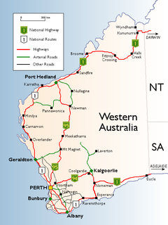
National Highways

- Eyre HighwayEyre HighwayThe Eyre Highway is a highway linking Western Australia and South Australia via the Nullarbor Plain. Signed as National Highway 1/A1, it forms part of Highway 1 and the Australian National Highway network linking Perth and Adelaide. It was named after explorer Edward John Eyre, who was the first to...
- Great Northern HighwayGreat Northern HighwayThe Great Northern Highway is a generally north-south Western Australian highway which links the state's capital Perth with its most northern port, Wyndham. It is in length, with being National Highway...
- Victoria HighwayVictoria HighwayThe Victoria Highway is a 524 kilometre highway linking the Great Northern Highway in Western Australia with the Stuart Highway in the Northern Territory. It is a part of the Perth - Darwin National Highway link. It is signed as National Highway 1 and is also a part of the Highway 1 network. It is...
- Eyre Highway

- Coolgardie-Esperance HighwayCoolgardie-Esperance HighwayThe Coolgardie–Esperance Highway is a 368 km Western Australian highway between Coolgardie and Esperance. It runs in a north-south direction linking the WA's Eastern Goldfields to the coast....
- Great Eastern HighwayGreat Eastern HighwayThe Great Eastern Highway is a major road between the Western Australian cities of Perth and Kalgoorlie. It is a key route for vehicles accessing the eastern wheatbelt and the eastern goldfields...
- Great Eastern Highway BypassGreat Eastern Highway BypassGreat Eastern Highway Bypass is a limited-access dual carriageway linking Great Eastern Highway and Roe Highway in Perth, Western Australia.It was opened on 14 May 1988....
- Roe HighwayRoe HighwayRoe Highway is a limited access dual carriageway in Western Australia. It links Great Northern Highway and Middle Swan Road with Kwinana Freeway. It is one of the key heavy vehicle routes in the Perth metropolitan area. Aside from intersections, the speed limit is 100 km/h for most of its length...
- Coolgardie-Esperance Highway

- Great Northern HighwayGreat Northern HighwayThe Great Northern Highway is a generally north-south Western Australian highway which links the state's capital Perth with its most northern port, Wyndham. It is in length, with being National Highway...
- Roe HighwayRoe HighwayRoe Highway is a limited access dual carriageway in Western Australia. It links Great Northern Highway and Middle Swan Road with Kwinana Freeway. It is one of the key heavy vehicle routes in the Perth metropolitan area. Aside from intersections, the speed limit is 100 km/h for most of its length...
- Great Northern Highway
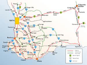
State Highways

- Brand HighwayBrand HighwayBrand Highway is a 362 kilometre main highway linking the northern outskirts of Perth, the capital of Western Australia, to the port city of Geraldton in Western Australia's Mid West region. Together with North West Coastal Highway, it forms part of the Western Australian coastal link to the...
- Canning HighwayCanning HighwayCanning Highway is a mostly 4 lane single carriageway major arterial road in Perth, Western Australia. The speed limit is 60 km/h. It is located south of the Swan River and links Perth with Fremantle, running between The Causeway in Victoria Park and Queen Victoria Street in...
- Coolgardie-Esperance HighwayCoolgardie-Esperance HighwayThe Coolgardie–Esperance Highway is a 368 km Western Australian highway between Coolgardie and Esperance. It runs in a north-south direction linking the WA's Eastern Goldfields to the coast....
- Great Eastern HighwayGreat Eastern HighwayThe Great Eastern Highway is a major road between the Western Australian cities of Perth and Kalgoorlie. It is a key route for vehicles accessing the eastern wheatbelt and the eastern goldfields...
- Great Northern HighwayGreat Northern HighwayThe Great Northern Highway is a generally north-south Western Australian highway which links the state's capital Perth with its most northern port, Wyndham. It is in length, with being National Highway...
- Leach HighwayLeach HighwayLeach Highway is a major dual carriageway arterial road in Perth, Western Australia, which varies between 4 and 6 lanes wide. The speed limit is either 70 or 80 km/h. It is located south of the Swan River and links Fremantle with Kewdale, a distance of ....
- North West Coastal HighwayNorth West Coastal HighwayNorth West Coastal Highway in Western Australia is a generally north-south Western Australian highway which links the fishing town of Geraldton with the iron ore port of Port Hedland. It is long, and constructed as a sealed 2-lane single carriageway with overtaking lanes in some parts. It was...
- Old Coast RoadOld Coast RoadOld Coast Road is a Western Australian highway linking Mandurah, WA's second-largest city located 75 km south of Perth, with Bunbury, WA's third-largest city. It is signed as Route 1 for most of its length and is long.-Overview:...
- South Coast HighwaySouth Coast HighwaySouth Coast Highway is a Western Australia highway. It is a part of the Highway 1 network.With a length of , it runs from Esperance to Walpole roughly in parallel to the Western Australia's south coast...
- South Western HighwaySouth Western HighwaySouth Western Highway is a highway in the South West region of Western Australia connecting Perth's southeast with Walpole. It is a part of the National Highway 1 network for most of its length...
- Brand Highway
 Forrest Highway
- Reid HighwayReid HighwayReid Highway is a major arterial highway in Perth, Western Australia. It is allocated Route 3, and runs between Marmion Avenue, North Beach, and West Swan Road, West Swan, a distance of...
- Roe HighwayRoe HighwayRoe Highway is a limited access dual carriageway in Western Australia. It links Great Northern Highway and Middle Swan Road with Kwinana Freeway. It is one of the key heavy vehicle routes in the Perth metropolitan area. Aside from intersections, the speed limit is 100 km/h for most of its length...
- Reid Highway
 Tonkin HighwayTonkin HighwayTonkin Highway, at , is a limited access dual carriageway in Perth, Western Australia, connecting Reid Highway in the north with Thomas Road in the south. Mostly a 4 lane highway, some sections of the highway are to a 4 to 6 lane freeway standard; the remainder of the highway has been designed to...
 Stirling HighwayStirling HighwayStirling Highway is, for most of its length, a four-lane single carriageway and major arterial road between Perth, Western Australia and the port city of Fremantle in Western Australia on the northern side of the Swan River. The speed limit is 60 km/h...
 Canning HighwayCanning HighwayCanning Highway is a mostly 4 lane single carriageway major arterial road in Perth, Western Australia. The speed limit is 60 km/h. It is located south of the Swan River and links Perth with Fremantle, running between The Causeway in Victoria Park and Queen Victoria Street in...
 Leach HighwayLeach HighwayLeach Highway is a major dual carriageway arterial road in Perth, Western Australia, which varies between 4 and 6 lanes wide. The speed limit is either 70 or 80 km/h. It is located south of the Swan River and links Fremantle with Kewdale, a distance of ....
- Brockman HighwayBrockman HighwayBrockman Highway is a highway in Western Australia. A few hours south of Perth, it runs west from Bridgetown via Nannup to Karridale.Nannup is situated at the junction of the Vasse Highway and the Brockman Highway....
- Bussell HighwayBussell HighwayBussell Highway is a generally north-south highway in the South West of Western Australia. The highway links the city of Bunbury with the town of Augusta and is approximately 150 km in length...
- Vasse HighwayVasse HighwayVasse Highway is a Western Australian highway connecting Busselton and the South Western Highway 15 km south of Manjimup. It is long and travels through jarrah and karri hardwood forests for most of its length, with some small agricultural areas and wineries nearby, and forms the main street...
- Brockman Highway
 South Western HighwaySouth Western HighwaySouth Western Highway is a highway in the South West region of Western Australia connecting Perth's southeast with Walpole. It is a part of the National Highway 1 network for most of its length...
 Albany HighwayAlbany HighwayAlbany Highway is a generally northwest-southeast highway in the south of Western Australia which links the state's capital Perth with its oldest settlement, Albany. The highway is approximately in length, is designated State Route 30 and separates Western Australia's Great Southern region from...
 Brookton HighwayBrookton HighwayBrookton Highway is a 504 kilometre long undivided single carriageway highway in Western Australia, running from the southern Perth suburb of Kelmscott, through Westdale, to the southern Wheatbelt town of Brookton...
 West Coast HighwayWest Coast HighwayWest Coast Highway is a major arterial coastal road located in the western and inner northern suburbs of Perth, Western Australia, commencing slightly inland in Swanbourne and heading north via the SAS Campbell Barracks and rifle range to City Beach, Scarborough and Trigg, terminating at the...
- Goldfields HighwayGoldfields HighwayGoldfields Highway is a generally northwest-southeast highway in central Western Australia which links the Great Northern Highway at Meekatharra with Coolgardie-Esperance Highway south of Kalgoorlie...
- Great Eastern HighwayGreat Eastern HighwayThe Great Eastern Highway is a major road between the Western Australian cities of Perth and Kalgoorlie. It is a key route for vehicles accessing the eastern wheatbelt and the eastern goldfields...
- Goldfields Highway
 Muirs HighwayMuirs HighwayMuirs Highway is a Western Australian highway linking Manjimup and Mount Barker on the Albany Highway. It is signed as State Route 102 and is long. It provides a shorter distance between Manjimup and Albany...
 Vasse HighwayVasse HighwayVasse Highway is a Western Australian highway connecting Busselton and the South Western Highway 15 km south of Manjimup. It is long and travels through jarrah and karri hardwood forests for most of its length, with some small agricultural areas and wineries nearby, and forms the main street...
 Coalfields Highway
 Great Southern HighwayGreat Southern HighwayGreat Southern Highway is a highway in the Southern Wheatbelt region of Western Australia, starting from Great Eastern Highway at The Lakes, 50 km from Perth, and ending at Albany Highway near Cranbrook. It is the primary thoroughfare for this part of Western Australia and runs parallel with the...
Major Arterial Roads
 Mandjoogoordap DriveMandjoogoordap DriveMandjoogoordap Drive, meaning "meeting place of the heart" in the indigenous Noongar language, is a dual carriageway road which links the Western Australian city of Mandurah to the Kwinana Freeway. It was officially opened on the 7th October 2010...
 Great Eastern HighwayGreat Eastern HighwayThe Great Eastern Highway is a major road between the Western Australian cities of Perth and Kalgoorlie. It is a key route for vehicles accessing the eastern wheatbelt and the eastern goldfields...
 Wanneroo Road (Perth-Lancelin Highway)Wanneroo RoadWanneroo Road is an important arterial road in Perth, Australia. It is about 75 kilometres long. It links Perth with the City of Wanneroo, and the Towns of Yanchep and Lancelin...
 Geraldton-Mount Magnet RoadGeraldton-Mount Magnet RoadGeraldton-Mount Magnet Road is a 333 kilometre major regional road in the Mid West region of Western Australia, starting in Utakarra in Geraldton's eastern suburbs, and terminating east-northeast at Great Northern Highway near the mining town of Mount Magnet...
Outback Tracks
As the outbackOutback
The Outback is the vast, remote, arid area of Australia, term colloquially can refer to any lands outside the main urban areas. The term "the outback" is generally used to refer to locations that are comparatively more remote than those areas named "the bush".-Overview:The outback is home to a...
covers most of Western Australia, tracks provide vital links to remote communities and settlements. It must be emphasised that these tracks are unsealed, remote and in many cases pass through restricted areas. They should only be negotiated by experienced drivers.
 Duncan RoadDuncan RoadDuncan Road is a generally northeast-southwest former highway in the northeast of Western Australia and northwest of Northern Territory which links the Victoria Highway with Halls Creek...
 Buntine HighwayBuntine HighwayThe Buntine Highway is a 570 kilometre highway in the Northern Territory and Western Australia, Australia. It runs from the Victoria Highway via Top Springs and Kalkaringi and then to Halls Creek, Western Australia...
- Anne Beadell HighwayAnne Beadell HighwayThe Anne Beadell Highway is an outback unsealed track linking Coober Pedy, South Australia, and Laverton, Western Australia. The track was surveyed and built by Len Beadell, Australian surveyor, who named it after his wife. -Overview:...
- Canning Stock RouteCanning Stock RouteThe Canning Stock Route is one of the toughest and most remote tracks in the world. It runs to Halls Creek from Wiluna, both in Western Australia. With a total distance of around it is also the longest historic stock route in the world...
- Cape Leveque RoadCape Leveque RoadThe Cape Leveque Road is a regional Western Australian road that runs through pindan woodland for between Broome and Cape Leveque on the Dampier Peninsula. The road is bitumened from south of Beagle Bay to the northern towns, and the unsealed southern section is often closed during the wet season...
- Connie Sue HighwayConnie Sue HighwayThe Connie Sue Highway is an outback road that runs from Rawlinna on the Trans-Australian Railway to the Aboriginal community of Warburton on the Great Central Road. Approximately long and running north-south, it lies entirely in the state of Western Australia and crosses the Nullarbor Plain and...
- Gary HighwayGary HighwayThe Gary Highway is a remote road in central Western Australia built by Len Beadell's Gunbarrel Road Construction Party in April and May 1963 and named after Beadell's son who was born earlier that year....
- Gibb River RoadGibb River RoadThe Gibb River Road is a former cattle route that stretches almost through The Kimberley between the Western Australian town of Derby and the Kununurra and Wyndham junction of the Great Northern Highway. Like its namesake, which does not actually cross the road but runs nearby at , it is named...
- Great Central RoadGreat Central RoadThe Great Central Road is a mostly unsealed Australian outback highway that runs 1126 km from Laverton, Western Australia to Yulara, Northern Territory ....
- Gunbarrel HighwayGunbarrel HighwayThe Gunbarrel Highway is an isolated desert track in the Northern Territory, South Australia and Western Australia. It consists of about of washaways, heavy corrugations, stone, sand and flood plains...
- Kalumburu RoadKalumburu RoadKalumburu Road in the Kimberley Region of Western Australia is a 267 kilometre road that connects the Gibb River Road to the aboriginal community of Kalumburu on the coast via the Mitchell Plateau. The road, which often becomes inaccessible during the Wet season, is suitable for 4WD traffic and...
- Tanami Road
See also
- Highways in AustraliaHighways in AustraliaThis is a list of highways in Australia, listed alphabetically along with each highway's route number and location. Note that some highways service more than one state or territory.-Route numbering systems:...
for highways in other statesStates and territories of AustraliaThe Commonwealth of Australia is a union of six states and various territories. The Australian mainland is made up of five states and three territories, with the sixth state of Tasmania being made up of islands. In addition there are six island territories, known as external territories, and a... - List of roadhouses in Western Australia