
Gosnells, Western Australia
Encyclopedia
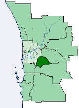
The City of Gosnells is a Local Government Area
in the southeastern suburbs of the Western Australia
n capital city of Perth
, located northwest of Armadale
and about 20 kilometres (12 mi) southeast of Perth's central business district
. The City covers an area of 128 square kilometres (49.42 sq mi), much of which is state forest rising into the Darling Scarp
to the east, and has an estimated population of 106,724 as at June 2010.
in the area and the marketing contributed to the myth about the Gosnell company, being so successful that the Gosnells railway station was constructed on the Armadale line in 1903.
Gosnells Road District was created out of the abolished Canning Road District on 1 July 1907. In 1923, it received land from Jandakot Road District when that entity was abolished.
On 1 July 1961, Gosnells Road District became a Shire following enactment of the Local Government Act 1960. On 1 July 1973 it became a Town and exactly four years later it attained City status.
( * indicates suburb partially located within City)
Local Government Areas of Western Australia
The Australian state of Western Australia is divided into 141 local government areas...
in the southeastern suburbs of the Western Australia
Western Australia
Western Australia is a state of Australia, occupying the entire western third of the Australian continent. It is bounded by the Indian Ocean to the north and west, the Great Australian Bight and Indian Ocean to the south, the Northern Territory to the north-east and South Australia to the south-east...
n capital city of Perth
Perth, Western Australia
Perth is the capital and largest city of the Australian state of Western Australia and the fourth most populous city in Australia. The Perth metropolitan area has an estimated population of almost 1,700,000....
, located northwest of Armadale
Armadale, Western Australia
Armadale is a suburb within the City of Armadale, located on the south-eastern edge of Perth's metropolitan area. The major junction of the South Western and Albany Highways, which connect Perth with the South West and Great Southern regions of Western Australia respectively, is located within the...
and about 20 kilometres (12 mi) southeast of Perth's central business district
Central business district
A central business district is the commercial and often geographic heart of a city. In North America this part of a city is commonly referred to as "downtown" or "city center"...
. The City covers an area of 128 square kilometres (49.42 sq mi), much of which is state forest rising into the Darling Scarp
Darling Scarp
The Darling Scarp, also referred to as the Darling Range or Darling Ranges, is a low escarpment running north-south to the east of the Swan Coastal Plain and Perth, Western Australia...
to the east, and has an estimated population of 106,724 as at June 2010.
History
The name Gosnells dates back to 1862 when Charles Gosnell who was the owner of London cosmetic company John Gosnell & Co., brought Canning location 16 from the Davis family who were the original grantees in 1829. While the purchase of the land was a personal investment by Charles Gosnell when the land was sold to developers in 1903 the developers used the association to the well known cosmetic company claiming it had brought the land because of its fertile soil to grow flowers of for the manufacture of its perfume range. The abundance of the Arum LilyZantedeschia aethiopica
Zantedeschia aethiopica ; syn. Calla aethiopica L., Richardia africana Kunth, Richardia aethiopica Spreng., Colocasia aethiopica Spreng...
in the area and the marketing contributed to the myth about the Gosnell company, being so successful that the Gosnells railway station was constructed on the Armadale line in 1903.
Gosnells Road District was created out of the abolished Canning Road District on 1 July 1907. In 1923, it received land from Jandakot Road District when that entity was abolished.
On 1 July 1961, Gosnells Road District became a Shire following enactment of the Local Government Act 1960. On 1 July 1973 it became a Town and exactly four years later it attained City status.
Wards
The city has been divided into 3 wards, each of 4 councillors. The mayor is directly elected.- Canning Vale Ward
- Bickley Ward
- Gosnells Ward
Suburbs
- BeckenhamBeckenham, Western AustraliaBeckenham is a suburb of Perth, Western Australia, located within the City of Gosnells.-History:This suburb has seen many name changes. It was most recently known as Buckingham, it once shared a "common usage" name of Waverley with East Cannington, and has one of the oldest primary schools in...
- Canning ValeCanning Vale, Western AustraliaCanning Vale is a large southern suburb of Perth, and is located 20 km from the Perth CBD. Its Local Government Areas are the City of Canning and the City of Gosnells .-History:...
* - GosnellsGosnells, Western AustraliaThe City of Gosnells is a Local Government Area in the southeastern suburbs of the Western Australian capital city of Perth, located northwest of Armadale and about southeast of Perth's central business district...
- HuntingdaleHuntingdale, Western AustraliaHuntingdale, Western Australia is a southeastern suburb of Perth, Western Australia. It is part of the City of Gosnells local government area. It is largely a residential suburb with associated schools and small businesses, mainly existing to service local residents...
- KenwickKenwick, Western AustraliaKenwick, Western Australia is a mixed residential, light industrial and semi-rural suburb located in the south-east of Perth, Western Australia, located within the City of Gosnells...
- LangfordLangford, Western AustraliaLangford is a suburb of Perth, Western Australia, located within the City of Gosnells. Its postcode is 6147.Langford is a working-class residential suburb located approximately 11 km from Perth's central business district. Recently the suburb has been upgraded and redeveloped, especially since...
- MaddingtonMaddington, Western AustraliaMaddington is a suburb 20 kilometres southeast of the central business district of Perth, the capital of Western Australia, within the City of Gosnells local government area...
- MartinMartin, Western AustraliaMartin is a suburb of Perth, Western Australia, located within the City of Gosnells. It was named in 1974 after a pioneer family of the Gosnells district, and in particular Edward Victor Martin who had served for 37 years on the council....
- Orange GroveOrange Grove, Western AustraliaOrange Grove is a suburb of Perth, Western Australia, located within the City of Gosnells.In 2006, the local primary school, Orange Grove Primary School, became the first school in Western Australia to produce a podcast, with its show entitled Podkids Australia.Despite the name, Bickley Dam is...
- Southern RiverSouthern River, Western AustraliaSouthern River is a suburb of Perth, Western Australia, located within the City of Gosnells.It was originally a rural area with chicken farms for egg production, horse breeding properties and boarding kennels for cats and dogs...
- ThornlieThornlie, Western AustraliaThornlie is a large outer suburb of Perth, Western Australia, located 18 kilometres south-east of Perth's central business district. It is part of the City of Gosnells local government area. The Canning River runs through the northern side of the suburb...
( * indicates suburb partially located within City)
Population
| Year | Population |
|---|---|
| 1911 | 737 |
| 1921 | 1,936 |
| 1933 | 3,016 |
| 1947 | 4,405 |
| 1954 | 7,366 |
| 1961 | 7,524 |
| 1966 | 11,374 |
| 1971 | 22,040 |
| 1976 | 40,422 |
| 1981 | 52,419 |
| 1986 | 60,610 |
| 1991 | 69,342 |
| 1996 | 73,421 |
| 2001 | 79,782 |
| 2006 | 91,579 |