
Slaughterbridge
Encyclopedia
Slaughterbridge, Treague and Camelford Station are three adjoining settlements in north Cornwall
, United Kingdom
. They straddle the boundary of Forrabury and Minster
and Lanteglos by Camelford
civil parish
es just over a mile (2 km) north-west of the market town of Camelford
The settlements are on the B3314 road from the A39 to Delabole
(now part of a busy route from the A30
near Launceston to north Cornwall).
 At Slaughterbridge the B3314 road drops dramatically into the valley of the River Camel
, describing a steeply graded 'S' bend and narrowing over the eponymous single-track bridge over the river.
Slaughterbridge is a very old settlement and is said to take its name from two battles which reputedly took place nearby during the Early Middle Ages
. As 'slaughter' is an Old English word for 'marsh' it provides no evidence that battles were fought here (see Galford
for the battle of Gafulford).
Worthyvale Manor (mentioned in the Domesday Book
although the current building is 17th century) lies north of the bridge and there are several other sites of archeological interest to the north and east of the river.
Not far from Worthyvale beside the river at Slaughterbridge is a memorial stone which bears ogham and Latin
inscriptions (Latini [h]ic iacit fili Macari = Latinus son of Macarus lies here). The stone lies in the remains of an 18th century garden created by Charlotte Boscawen, Dowager Lady Falmouth (the daughter of Hugh Boscawen
- see Great Cornish families
). It dates from the sixth century and is thought to commemorate an unknown Celtic chieftain.
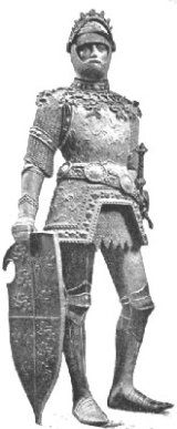
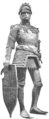
Legendary and folk associations link this stone with the place where King Arthur
met Mordred
for the decisive Battle of Camlann
in 537. Often referred to as 'King Arthur's Stone', it was first recorded by Cornish antiquary Richard Carew in 1602 but had lain on the river bank for at least a thousand years prior to that.
An early narrative account of King Arthur's life is found in Historia Regum Britanniae
("History of the Kings of Britain") by Geoffrey of Monmouth
completed around 1138. Geoffrey favours a river bridge as the site of Arthur's last battle: "Arthur was filled with great mental anguish by the fact that Mordred had escaped him so often. Without losing a moment, he followed him to that same locality, reaching the River Camlann, where Mordred was awaiting his arrival."
Alfred, Lord Tennyson
described King Arthur's Stone after a visit to Slaughterbridge in June, 1848. Among Tennyson's best-known work is Idylls of the King
, a work devoted to the legend of King Arthur.
It is thought by some that Camelford was the site of Arthur's fabled court of Camelot
, both because of the similarity of name and the proximity of Slaughterbridge.
To the east of Treague are the earthworks and enclosure of a small medieval settlement called Old Melorne. A medieval village is first recorded here in 1296 but by the 18th century, documents refer only to a farm at the site. The name is commemorated by present-day Melorne Farm, a few hundred yards west at Camelford Station crossroads.
Archeologist Nick Hankshttp://nickhanks.blogspot.com/2007/09/biography.html, currently working for English Heritage with the National Monument Record Centre, runs an archeological project called 'Slaughterbridge Training Excavation Project' (STEP) in the area around Slaughterbridge and Treague.
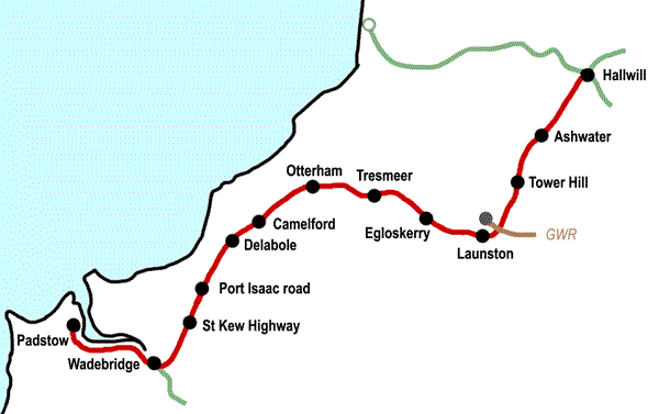 Camelford Station is half-a-mile east of Treague at the junction of the B3314 and the B3266 from Camelford to Boscastle
at . The former station gives its name to the crossroads, a fact recognised on the roadsigns at the junction, and a hamlet. The settlement consists of a farm (Melorne) and its buildings, the former station building and a few other properties including a Methodist chapel.
The former Camelford railway station was on the ex-LSWR North Cornwall line
which ran from Halwill
to Wadebridge
and Padstow
. Camelford Station was opened in 1893 and it closed in October 1966 when services on the line from Halwill to Wadebridge ended.
Although named after nearby Camelford, the station was in Minster parish well over a mile from the town it served. It was located "at a road junction in wild country almost devoid of trees" which remains an apt description of the exposed location. Camelford railway station served not only Camelford, but also Tintagel
and Boscastle
(which did not have a closer rail link) with bus services operated by Southern National
connecting the villages with the station.
The main station building was substantially built from local stone and provided accommodation for the stationmaster. It is now a private residence and home to the British Cycling Museum. This small museum is a private enterprise set up by an enthusiastic couple and consists of a comprehensive collection of over 400 vehicles, cycling memorabilia and an old cycle repair workshop.
The museum is now closed.
West of Camelford station are a few isolated dwellings and the village of Delabole
.
Cornwall
Cornwall is a unitary authority and ceremonial county of England, within the United Kingdom. It is bordered to the north and west by the Celtic Sea, to the south by the English Channel, and to the east by the county of Devon, over the River Tamar. Cornwall has a population of , and covers an area of...
, United Kingdom
United Kingdom
The United Kingdom of Great Britain and Northern IrelandIn the United Kingdom and Dependencies, other languages have been officially recognised as legitimate autochthonous languages under the European Charter for Regional or Minority Languages...
. They straddle the boundary of Forrabury and Minster
Forrabury and Minster
Forrabury and Minster is a civil parish on the north coast of Cornwall. The parish was originally divided between the coastal parish of Forrabury and inland parish of Minster until they were united in 1779....
and Lanteglos by Camelford
Camelford
Camelford is a town and civil parish in north Cornwall, United Kingdom, situated in the River Camel valley northwest of Bodmin Moor. The town is approximately ten miles north of Bodmin and is governed by Camelford Town Council....
civil parish
Civil parish
In England, a civil parish is a territorial designation and, where they are found, the lowest tier of local government below districts and counties...
es just over a mile (2 km) north-west of the market town of Camelford
Camelford
Camelford is a town and civil parish in north Cornwall, United Kingdom, situated in the River Camel valley northwest of Bodmin Moor. The town is approximately ten miles north of Bodmin and is governed by Camelford Town Council....
The settlements are on the B3314 road from the A39 to Delabole
Delabole
Delabole is a large village in north Cornwall, England, UK. It is situated approximately two miles west of Camelford.The village of Delabole came into existence in the 20th century; it is named after the Delabole Quarry. There were three hamlets: Pengelly, Medrose and Rockhead...
(now part of a busy route from the A30
A30 road
The 284 miles A30 road from London to Land's End, historically known as the Great South West Road used to provide the most direct route from London to the south west; more recently the M3 motorway and A303 road performs this function for much of the route and only parts of A30 now retain trunk...
near Launceston to north Cornwall).
Slaughterbridge
River Camel
The River Camel is a river in Cornwall, UK. It rises on the edge of Bodmin Moor and together with its tributaries drains a considerable part of North Cornwall. The river issues into the Celtic Sea area of the Atlantic Ocean between Stepper Point and Pentire Point having covered a distance of...
, describing a steeply graded 'S' bend and narrowing over the eponymous single-track bridge over the river.
Slaughterbridge is a very old settlement and is said to take its name from two battles which reputedly took place nearby during the Early Middle Ages
Early Middle Ages
The Early Middle Ages was the period of European history lasting from the 5th century to approximately 1000. The Early Middle Ages followed the decline of the Western Roman Empire and preceded the High Middle Ages...
. As 'slaughter' is an Old English word for 'marsh' it provides no evidence that battles were fought here (see Galford
Galford
Galford can refer to:* Galford, a place near Lewdown in Devon, England, the site of a battle between Cornish and Devonian forces in the early 9th century...
for the battle of Gafulford).
Worthyvale Manor (mentioned in the Domesday Book
Domesday Book
Domesday Book , now held at The National Archives, Kew, Richmond upon Thames in South West London, is the record of the great survey of much of England and parts of Wales completed in 1086...
although the current building is 17th century) lies north of the bridge and there are several other sites of archeological interest to the north and east of the river.
Not far from Worthyvale beside the river at Slaughterbridge is a memorial stone which bears ogham and Latin
Latin
Latin is an Italic language originally spoken in Latium and Ancient Rome. It, along with most European languages, is a descendant of the ancient Proto-Indo-European language. Although it is considered a dead language, a number of scholars and members of the Christian clergy speak it fluently, and...
inscriptions (Latini [h]ic iacit fili Macari = Latinus son of Macarus lies here). The stone lies in the remains of an 18th century garden created by Charlotte Boscawen, Dowager Lady Falmouth (the daughter of Hugh Boscawen
Hugh Boscawen, 1st Viscount Falmouth
Hugh Boscawen, 1st Viscount Falmouth was an English Whig politician who sat in the House of Commons for Cornish constituencies from 1702 until 1720 when he was raised to the peerage.-Life:...
- see Great Cornish families
Great Cornish families
Great Cornish families: a history of the people and their houses is a book by Crispin Gill, published in 1995. The authorCrispin Gill, at the time of the book's publication lived in Plymouth and was Assistant Editor of the Western Morning News...
). It dates from the sixth century and is thought to commemorate an unknown Celtic chieftain.
Legendary and folk associations link this stone with the place where King Arthur
King Arthur
King Arthur is a legendary British leader of the late 5th and early 6th centuries, who, according to Medieval histories and romances, led the defence of Britain against Saxon invaders in the early 6th century. The details of Arthur's story are mainly composed of folklore and literary invention, and...
met Mordred
Mordred
Mordred or Modred is a character in the Arthurian legend, known as a notorious traitor who fought King Arthur at the Battle of Camlann, where he was killed and Arthur fatally wounded. Tradition varies on his relationship to Arthur, but he is best known today as Arthur's illegitimate son by his...
for the decisive Battle of Camlann
Battle of Camlann
The Battle of Camlann is best known as the final battle of King Arthur, where he either died in battle, or was fatally wounded fighting his enemy Mordred.-Historicity:...
in 537. Often referred to as 'King Arthur's Stone', it was first recorded by Cornish antiquary Richard Carew in 1602 but had lain on the river bank for at least a thousand years prior to that.
An early narrative account of King Arthur's life is found in Historia Regum Britanniae
Historia Regum Britanniae
The Historia Regum Britanniae is a pseudohistorical account of British history, written c. 1136 by Geoffrey of Monmouth. It chronicles the lives of the kings of the Britons in a chronological narrative spanning a time of two thousand years, beginning with the Trojans founding the British nation...
("History of the Kings of Britain") by Geoffrey of Monmouth
Geoffrey of Monmouth
Geoffrey of Monmouth was a cleric and one of the major figures in the development of British historiography and the popularity of tales of King Arthur...
completed around 1138. Geoffrey favours a river bridge as the site of Arthur's last battle: "Arthur was filled with great mental anguish by the fact that Mordred had escaped him so often. Without losing a moment, he followed him to that same locality, reaching the River Camlann, where Mordred was awaiting his arrival."
Alfred, Lord Tennyson
Alfred Tennyson, 1st Baron Tennyson
Alfred Tennyson, 1st Baron Tennyson, FRS was Poet Laureate of the United Kingdom during much of Queen Victoria's reign and remains one of the most popular poets in the English language....
described King Arthur's Stone after a visit to Slaughterbridge in June, 1848. Among Tennyson's best-known work is Idylls of the King
Idylls of the King
Idylls of the King, published between 1856 and 1885, is a cycle of twelve narrative poems by the English poet Alfred, Lord Tennyson which retells the legend of King Arthur, his knights, his love for Guinevere and her tragic betrayal of him, and the rise and fall of Arthur's kingdom...
, a work devoted to the legend of King Arthur.
It is thought by some that Camelford was the site of Arthur's fabled court of Camelot
Camelot
Camelot is a castle and court associated with the legendary King Arthur. Absent in the early Arthurian material, Camelot first appeared in 12th-century French romances and eventually came to be described as the fantastic capital of Arthur's realm and a symbol of the Arthurian world...
, both because of the similarity of name and the proximity of Slaughterbridge.
Treague
The hamlet of Treague is on the north side of the B3314 road, at the top of the hill up from Slaughterbridge. There is a commercial Arthurian Centre http://www.arthur-online.com/ at Treague with car parking, a gift shop and tea rooms. It features a display of Arthur memorabila.To the east of Treague are the earthworks and enclosure of a small medieval settlement called Old Melorne. A medieval village is first recorded here in 1296 but by the 18th century, documents refer only to a farm at the site. The name is commemorated by present-day Melorne Farm, a few hundred yards west at Camelford Station crossroads.
Archeologist Nick Hankshttp://nickhanks.blogspot.com/2007/09/biography.html, currently working for English Heritage with the National Monument Record Centre, runs an archeological project called 'Slaughterbridge Training Excavation Project' (STEP) in the area around Slaughterbridge and Treague.
Camelford Station
Boscastle
Boscastle is a village and fishing port on the north coast of Cornwall, England, in the civil parish of Forrabury and Minster. It is situated 14 miles south of Bude and 5 miles north-east of Tintagel....
at . The former station gives its name to the crossroads, a fact recognised on the roadsigns at the junction, and a hamlet. The settlement consists of a farm (Melorne) and its buildings, the former station building and a few other properties including a Methodist chapel.
The former Camelford railway station was on the ex-LSWR North Cornwall line
North Cornwall Railway
The North Cornwall Railway was a railway line running from Halwill in Devon to Padstow in Cornwall via Launceston, Camelford and Wadebridge, a distance of 49 miles 67 chains. Opened in the last decade of the nineteenth century, it was part of a drive by the London and South Western Railway to...
which ran from Halwill
Halwill Junction railway station
Halwill Junction Railway Station was a railway station near the villages of Halwill and Beaworthy in Devon. It opened in 1879 and formed an important junction between the now-closed Bude Branch and North Cornwall line...
to Wadebridge
Wadebridge
Wadebridge is a civil parish and town in north Cornwall, England, United Kingdom. The town straddles the River Camel five miles upstream from Padstow....
and Padstow
Padstow
Padstow is a town, civil parish and fishing port on the north coast of Cornwall, England, United Kingdom. The town is situated on the west bank of the River Camel estuary approximately five miles northwest of Wadebridge, ten miles northwest of Bodmin and ten miles northeast of Newquay...
. Camelford Station was opened in 1893 and it closed in October 1966 when services on the line from Halwill to Wadebridge ended.
Although named after nearby Camelford, the station was in Minster parish well over a mile from the town it served. It was located "at a road junction in wild country almost devoid of trees" which remains an apt description of the exposed location. Camelford railway station served not only Camelford, but also Tintagel
Tintagel
Tintagel is a civil parish and village situated on the Atlantic coast of Cornwall, United Kingdom. The population of the parish is 1,820 people, and the area of the parish is ....
and Boscastle
Boscastle
Boscastle is a village and fishing port on the north coast of Cornwall, England, in the civil parish of Forrabury and Minster. It is situated 14 miles south of Bude and 5 miles north-east of Tintagel....
(which did not have a closer rail link) with bus services operated by Southern National
Southern National
Southern National was a bus company operating in South West England from 1929 to 1969, and again from 1983 to 1999.-Original company :...
connecting the villages with the station.
The main station building was substantially built from local stone and provided accommodation for the stationmaster. It is now a private residence and home to the British Cycling Museum. This small museum is a private enterprise set up by an enthusiastic couple and consists of a comprehensive collection of over 400 vehicles, cycling memorabilia and an old cycle repair workshop.
The museum is now closed.
West of Camelford station are a few isolated dwellings and the village of Delabole
Delabole
Delabole is a large village in north Cornwall, England, UK. It is situated approximately two miles west of Camelford.The village of Delabole came into existence in the 20th century; it is named after the Delabole Quarry. There were three hamlets: Pengelly, Medrose and Rockhead...
.