

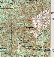
Sispara
Encyclopedia
Proper noun
A proper noun or proper name is a noun representing a unique entity , as distinguished from a common noun, which represents a class of entities —for example, city, planet, person or corporation)...
, is a combination of the Badaga language
Badaga language
The Badaga language is a southern Dravidian language spoken by approximately 400,000 people in the Nilgiri Hills in Southern India. It is known for its retroflex vowels. The word Badaga refers to the Badaga language as well as the Badaga community/tribe...
words si:su + pore; meaning: magnetite
Magnetite
Magnetite is a ferrimagnetic mineral with chemical formula Fe3O4, one of several iron oxides and a member of the spinel group. The chemical IUPAC name is iron oxide and the common chemical name is ferrous-ferric oxide. The formula for magnetite may also be written as FeO·Fe2O3, which is one part...
bearing rock + gorge. It may refer to:
- Sispara peak, a large hill in Kerala;
- Sispara bungalow, the shelter at the base of the peak;
- Sispara pass, the low gap between hills where the shelter is located; or
- Sispara ghat, the mountain trail that goes through the pass.
Sispara peak
Silent Valley National Park
Silent Valley National Park , is located in the Nilgiri Hills, Palakkad District in Kerala, South India...
, in Kerala
Kerala
or Keralam is an Indian state located on the Malabar coast of south-west India. It was created on 1 November 1956 by the States Reorganisation Act by combining various Malayalam speaking regions....
state, in the core area of the Nilgiri Biosphere Reserve
Nilgiri Biosphere Reserve
The Nilgiri Biosphere Reserve is an International Biosphere Reserve in the Western Ghats, Nilgiri Hills range of South India. The Western Ghats, Nilgiri Sub-Cluster , conjoining the Nilgiri Biosphere Reserve, is under consideration by the UNESCO World Heritage Committee for selection as a World...
, in the Western Ghats
Western Ghats
The Western Ghats, Western Ghauts or the Sahyādri is a mountain range along the western side of India. It runs north to south along the western edge of the Deccan Plateau, and separates the plateau from a narrow coastal plain along the Arabian Sea. The Western Ghats block rainfall to the Deccan...
of South India
South India
South India is the area encompassing India's states of Andhra Pradesh, Karnataka, Kerala and Tamil Nadu as well as the union territories of Lakshadweep and Pondicherry, occupying 19.31% of India's area...
. It is near the southwest end of Mukurthi National Park
Mukurthi National Park
Mukurthi National Park is a 78.46 km² protected area located in the south-eastern corner of the Nilgiris Plateau west of Ootacamund hill station in the northwest corner of Tamil Nadu state in the Western Ghats mountain range of South India...
in Tamil Nadu
Tamil Nadu
Tamil Nadu is one of the 28 states of India. Its capital and largest city is Chennai. Tamil Nadu lies in the southernmost part of the Indian Peninsula and is bordered by the union territory of Pondicherry, and the states of Kerala, Karnataka, and Andhra Pradesh...
state.
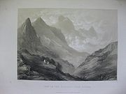
One can approach this peak by passing northwest up behind the bungalow, and ascending the high bluff below the peak. Half an hour's walk leads to a vertical precipice of the escarpment facing the plains of Malabar. Numerous lofty trees growing at the foot of the precipice reach the brim of this point. A walk along the edge of this escarpment brings one to a huge peaking mass of rock, a few hundred yards from the foot of the highest Sispara summit, which stands like a battlement on a wall. In 1886, Henry Francis Blanford
Henry Francis Blanford
Henry Francis Blanford was a British meteorologist and paleontologist who worked in India...
, geologist of the Geological Survey of India
Geological Survey of India
Geological Survey of India , established in 1851 is a government organization in India which is an attached office to the Ministry of Mines of Union Government of India for conducting geological surveys and studies. It is one of the oldest of such organizations in the world and the second oldest...
, described the view from this peak:
The view from this point is really magnificent, particularly that of the gigantic amphitheatre to the right, the termination of the Koondahs on this side. It is very striking to look at this stupendous semicircular recess, formed by enormously lofty mountains, the summits of which rise vertically to thousands of feet, and whose abrupt sides are deeply corroded by ravines and chasms, down which small but romantic cascades precipitate themselves, adding to the magnificence of this stupendous scenery..
Sispara peak is the abode of the Toda
Toda people
The Toda people are a small pastoral community who live on the isolated Nilgiri plateau of Southern India. Before the late 18th century, the Toda coexisted locally with other communities, including the Badaga, Kota, and Kuruba, in a loose caste-like community organization in which the Toda were...
tribes people ancestral spirits. It is the second highest peak in the core area of Silent Valley, Anginda peak
Anginda peak
Anginda peak is in the Nilgiri Hills of the Western Ghats in Kerala, South India. Its coordinate location is . It has an altitude is and is the highest peak in Silent Valley National Park.It is just south of Sispara pass, and forms the southernmost boundary of Mukurthi National Park in Tamil Nadu...
at 2383 metres (7,818 ft), being the highest. The forests near Sisapara are exposed to the full force of the southwest monsoon and receive up to 250 inches (635 cm) per year of rain, but suffer from a long drought during the winter.
Henry Blanford described this area well:
There is perhaps no scene in Southern India more grand and imposing than this gigantic escarpment. Rising abruptly from the low jungle covered plains of Malabar, to the lofty surface of the Koondah plateau, an elevation of nearly 8000 feet (2,438.4 m), a precipitous hill face covered with dense jungle, furrowed but not broken up by innumerable hill torrents which course down its surface, and glisten like silver threads amid the dark green foliage of the forest. It would seem at first sight perfectly inaccessible from the plains below, and such it is throughout the greater portion of its extent.
It is only at Sispara that, with considerable engineering skill, a road has been constructed, forming a communication between the hills and the low country of Malabar, and it is from this road that the finest view of the escarpment is obtainable.
Sispara bungalow
Madras Pioneers
The term Madras Pioneers related to bodies of Pioneers as well as Sappers and Miners which were part of the Madras Presidency Army.The Madras Engineer Group were raised as two companies of pioneers in 1780 called the Madras Pioneers, which were expanded and titled 'Corps of Madras Pioneers' but...
who made the road. It was first named Murraypet, after Captain W. Murray who was in charge of the detachment. A travelers bungalow was built there just below a strikingly sheer cliff of rock. Later a chattram (refreshment shed) was built beside that. While the trail was still in use, this place was a well known and much frequented halting-point on what was then the main route from Calicut to Ootacamnud.
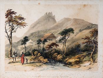
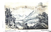
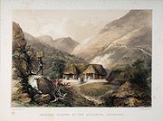
About 1840, a coloured lithograph of a painting by Captain Stephen Ponsonby Peacocke
Stephen Ponsonby Peacocke
Captain Stephen Ponsonby Peacocke , was a British officer of the Bombay Army and an artist notable for his 17 paintings of historic landscape views in the Nilgiri Hills in South India. Tinted lithographs were made of these views and published in imperial folio in London by the lithographer Paul...
shows that there was a small tiled bungalow, with a thatched outbuilding and a large tent at this place. It also shows the small seasonal stream between the trail and the bungalow.
A later lithograph of the place, which forms the frontispiece to the second edition of Baikie's Neilgherries, shows that by 1857, a tiled bungalow and a smaller shed stood there.After 1857, the bungalow at Sispara was accidentally burnt down and was never rebuilt. By 1908 it was deserted and overgrown.
A gruesome story is told of a poorly informed traveller who attempted to get to Ootacamund from the west coast by this route. One of his two servants quickly succumbed to exposure from the cold and driving rain of the monsoon. He set out up the ghat with the other, who collapsed soon afterward. The traveller took him on his back and struggled up the trail, buoyed with the hope of assistance and food when he reached the Sispara bungalow at the top. When he did finally arrive there, the only sign of the bungalow was its crumbling ruins, and the nearest human being was at Avalanche, 18 miles (29 km) miles further on! He managed to reach that place, still carrying his servant, but the latter had died on the way.
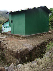
In 2007, a roughly 12 square metres (129.2 sq ft) new steel trekkers' shed was built on the old site. This shed is protected by an elephant-proof trench, and trekkers may use it with permission of the Wildlife Warden, Silent Valley National Park.
Sispara pass
Mountain pass
A mountain pass is a route through a mountain range or over a ridge. If following the lowest possible route, a pass is locally the highest point on that route...
between Sispara peak and Anginda peak. This is the lowest and most accessible passage through the steep western escarpment
Escarpment
An escarpment is a steep slope or long cliff that occurs from erosion or faulting and separates two relatively level areas of differing elevations.-Description and variants:...
of the Kundah range of the Nilgiri hills. Sispara pass is at the head of a long and deep ravine, enclosed between two almost perpendicular ridges. The Ghat trail is built along the side of the northwest ridge.
In the 19th century, this pass provided the shortest route for postal delivery between Ootacamund in the hills and Calicut on the West Coast and was used for smuggling of cannabis, tobacco and later salt.
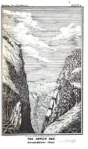
The Devil's Gap is a extraordinary chasm situated at the top of the escarpment, four miles (6 km) north of the steepest part of Sispara pass. The lower part of this chasm is nearly level with the road which passes close to it. The rocks forming its walls are about 100 yard apart in the center and near the opening it is about 150 yard wide.
Sispara ghat
The Sispara ghatGhats
As used in many parts of South Asia, the term ghat refers to a series of steps leading down to a water body, usually a holy river. In Bengali-speaking regions, this set of stairs can lead down to something as small as a pond or as large as a major river....
mountain road ran west-north-west 13 miles (20.9 km) from Ootacamand to Avalanche; then 9 miles (14.5 km) up the Kundahs to Bangitappal
Bangitappal
Bangitappal , is a valley in the southwest end of Mukurthi National Park located at: , elevation: at the confluence of two streams at the head of the Sispara Pass in the Western Ghats in Tamil Nadu South India....
; another 9 miles (14.5 km) to Sispara in the extreme south-western Corner of the plateau; and then 11.5 kilometres (7.1 mi) more down a steep descent to Walaghat (half way down the slope) and Sholakal at the bottom. From Sholakal to Arriakul
Areekode
Areekode ' is a small town located on the banks of Chaliyar River in Eranad Taluk of Malappuram district. Near places are Mukkam, Thiruvambady, Nilambur, Manjeri. Nilambur-Koyilandi SH pass through here....
on the Baypoor river
Chaliyar River
Chaliyar is the fourth longest river in Kerala at 169 km in length. The Chaliyar is also known as Beypore River as it nears the sea...
was 25.5 miles (41 km) and thence 35 miles (56.3 km) by large boat to Calicut port on the Indian Ocean
Indian Ocean
The Indian Ocean is the third largest of the world's oceanic divisions, covering approximately 20% of the water on the Earth's surface. It is bounded on the north by the Indian Subcontinent and Arabian Peninsula ; on the west by eastern Africa; on the east by Indochina, the Sunda Islands, and...
. Overall traveling distance between Calicut and Ootacamund by Sispara was 103 miles (165.8 km).
The first written report of the use of this route up into the Nilgiri hills was by an expedition of the Goa Inquisition
Goa Inquisition
The Goa Inquisition was the office of the Inquisition acting in the Indian state of Goa and the rest of the Portuguese empire in Asia. It was established in 1560, briefly suppressed from 1774–1778, and finally abolished in 1812. The Goan Inquisition is considered a blot on the history of...
led by the Jesuit
Society of Jesus
The Society of Jesus is a Catholic male religious order that follows the teachings of the Catholic Church. The members are called Jesuits, and are also known colloquially as "God's Army" and as "The Company," these being references to founder Ignatius of Loyola's military background and a...
priest Jacome Ferreira, from the Syrian Christian Church
Jacobite Syrian Christian Church
The Jacobite Syrian Christian Church is part of the Syriac Orthodox Church, located in Kerala, India. It recognizes the Syriac Orthodox Patriarch of Antioch, currently Ignatius Zakka I Iwas, as its supreme head. It functions as a largely autonomous archdiocese within the church, under the authority...
of the Malabar coast
Malabar Coast
The Malabar Coast is a long and narrow coastline on the south-western shore line of the mainland Indian subcontinent. Geographically, it comprises the wettest regions of southern India, as the Western Ghats intercept the moisture-laden monsoon rains, especially on their westward-facing mountain...
at Calicut. Ferreira's formal report, written upon his return on April 1, 1603, contained some account of the Badagas
Badagas
The Badagas are an indigenous people inhabiting the Nilgiri Hills of Tamil Nadu, southern India. Their language is Badaga.-Traditional Attire:In olden days the Badagas used to wear distinctive dresses...
and Todas. It states that he and his party returned by a better route than they arrived. The route was shown to them by the kindly Badagas, of which no account is given but which may have been the Sispara path.
In November 1831, development of the Sispara ghat, formerly known as the Koondah (Kundah) ghat, was suggested by Mr. Stephen Rumbold Lushington
Stephen Rumbold Lushington
Stephen Rumbold Lushington was an English Tory politician and an administrator in India. He was Governor of Madras from 1827 to 1835....
, then Governor of Madras, in order to provide a speedy route to Ootacamund
Ootacamund
Ootacamund , is a town, a municipality and the district capital of the Nilgiris district in the Indian state of Tamil Nadu. Ootacamund is a popular hill station located in the Nilgiri Hills...
from Calicut for invalids traveling by ship from Bombay.
In 1831, Major Crewe, Commandant of the Nilgiris, Lieutenant LeHardy, surveyor of the Coonoor ghat then under construction, and Captain Murray of the Pioneer Regiment, searched the western side of the plateau for a practicable route for a new road and at length heard of the Sispara path, which, though greatly overgrown, was then one of the obscure paths used by tobacco-smugglers.
Lieutenant LeHardy surveyed the best route for the trail afterwards called the Sispara ghat. Captain Murray and his Pioneers were entrusted with the construction of the road. Between January 10 and May 31, 1832, they established camps at Avalanche and Sispara and worked to clear and level the road with the aid of coolies and 'tank-diggers'.
On May 31, Capt. Murray reported that the Kundah pass, as it was then called, was open with a path down the slopes connecting with the roads on the Malabar plains. Sispara was known for some time as Murraypet. The route was so infested with elephants and tigers that the Collector of Malabar obtained sanction to purchase five large swivel mounted muskets (jingalls) and employ ten peon
Peon
The words peon and peonage are derived from the Spanish peón . It has a range of meanings but its primary usage is to describe laborers with little control over their employment conditions.-English usage:...
s (foot soldiers) to shoot the beasts and protect the coolie
Coolie
Historically, a coolie was a manual labourer or slave from Asia, particularly China, India, and the Phillipines during the 19th century and early 20th century...
s. The track was very rough but the monsoon set in and later the Pioneers were diverted to widening the Coonoor ghat. Work was not resumed till 1836.
The road was finished in 1838, with a gradient of one in nine. Bungalows for travellers were built at Sholakul, Walaghat, Sispara and Avalanche. The extraordinarily heavy rainfall at that end of the Kundahs necessitated large annual repairs in subsequent years. The trail was so steep that it was seldom used for laden cattle, and the climate was so severe and the shelter en route so insufficient that Europeans often could not get coolies to come with them to carry their baggage. The ghat thus failed to fulfill its high expectations. As early as 1841 it was declared to be 'rarely traversed except at the height of the dry season', and it was eventually abandoned. After 1857, the bungalow at Sispara was accidentally burnt down and was never rebuilt.
The following account of the ascent of Sispara Ghat by Clements Robert Markham defies editing.
We landed at the port of Calicut, on our way to the Nilgiri Hills, on the 7th October, 1860. He who would desire to receive the most pleasant impression of India, on a first arrival, must follow in the wake of Vasco da GamaVasco da GamaVasco da Gama, 1st Count of Vidigueira was a Portuguese explorer, one of the most successful in the Age of Discovery and the commander of the first ships to sail directly from Europe to India...
, and disembark on the coast of Malabar, the garden of the peninsula. Here Nature is clad in her brightest and most inviting robes, the scenery is magnificent, the fields and gardens speak of plenty, and the dwellings of the people are substantial and comfortable.
Late in the evening, we embarked in a canoe on the Beypur river. The banks are wooded down to the water's edge, with groves of slender betelBetelThe Betel is the leaf of a vine belonging to the Piperaceae family, which includes pepper and Kava. It is valued both as a mild stimulant and for its medicinal properties...
palms rising above the other foliage, and standing out against the starry sky. We were met by Mr. Mclvor at the landing-place of Eddiwana, and started at once for the village of WundurWandoorWandoor is a small town in Malppuram district of Kerala, India at. It is located near to Manjeri.The town is fast growing thanks to hundreds of NRIs...
, whence the road leads up the Sisapara ghat to the Nilgiris.
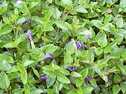
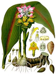
The ascent commences at Sholakul, a post-house surrounded by stout palisades, to protect it from wild elephants. Thence the road first passes through a tract overgrown with gigantic weeds, and then up a steep slope, covered with a forest of blackwood and other fine timber trees, with an undergrowth of ferns, CurcumaCurcumaCurcuma is a genus of about 80 accepted species in the plant family Zingiberaceae that contains such species as turmeric and Siam Tulip. The name comes from Arabic kurkum meaning "turmeric". Since assembly of the genus Curcuma by Linnaeus in 1753 about 130 species have been described so far...
s, and a brilliant little purple flower, the Wishbone Flower, Torenia AsiaticaToreniaTorenia is a genus of plants in the snapdragon family, Scrophulariaceae or also classified in Linderniaceae by some authors. Often called Wishbone flowers, some species are grown as garden plants. Many F1 and F2 Torenia hybrids have been hybridizied in the last 30 years. Colors can range from white...
(Torenia glabra). The occasional openings in the forest, at turns in the road, afforded us views of the mountains below us, covered with the richest vegetation, and of the rice-fields of Malabar, stretching away to the faintly indicated blending of sea and haze on the far horizon. As we continued the ascent the scenery increased in magnificence, the views became more extensive, and there were mountain-tops crowned with grand forest trees far below us. At 6000 feet mosses appear, then lilies, brambles, and wild strawberries, and occasionally we crossed noisy little streams overshadowed by the trees.
We reached the Sisapara bungalow, on the summit of the ghat 6742 feet above the level of the sea, late in the afternoon. The Sisapara ghat takes the traveller from the tropical plains to the temperate climate of the hills, where the face of Nature is entirely changed. Here the slopes are covered with grass, and the ravines only are filled with trees, forming thickets called sholas. In the rear of the Sisapara bungalow, there is an almost unrivalled view of the Malabar plains, from the edge of a precipice. The Kundah hills sweep round until they join the Wyanad range, and appeared to be so steep that even a cat could not scale them for many miles; and far below were the forests, with occasional open glades. The distance from Sisapara to Utakamand, the chief English station on the Nilgiris, is thirty-three miles, fifteen of which are over the Kundah hills, and the rest of the distance is within the Nilgiris proper.
Flora and fauna
From Sispara peak there is a panoramic view of deep valleys packed with dense vegetation. The Sispara pass leading down into Silent Valley, is enveloped in foliage and remains hidden even from the top of the peak.Robert Wight
Robert Wight
Robert Wight was a Scottish surgeon and botanist who spent 30 years in India. He studied botany in Edinburgh under John Hope. He was the director of the Botanic Garden in Madras. He made use of local artists to make illustrations of the plants around him...
, a surgeon turned botanist, ventured into this area in the middle of the 19th century. In the process, Wight discovered seven new species from Sispara and the adjoining jungles and as many as 122 Indian plants have been named after him.
The Sispara Day Gecko
Cnemaspis sisparensis
Sispara Day Gecko Cnemaspis sisparensis is a species of gecko found in the Nilgiri Hills of India.-Description:Closely allied to Cnemaspis wynadensis, but the digits much more elongate. 3 femoral pores on each side. Dorsal tubercles homogeneous...
is found here. The Gecko Geckoella nebulosa was abundant near the foot of the Sispara slopes.
The endangered plants Glochidion sisparense
Glochidion sisparense
Glochidion sisparense is a species of tree in the Phyllanthaceae family. It is endemic to Sispara, India.-Sources:* World Conservation Monitoring Centre 1998. . Downloaded on 21 August 2007....
, Ilex gardneriana
Ilex gardneriana
Ilex gardneriana was a species of plant in the Aquifoliaceae family. It was endemic to India. It became extinct due to habitat loss.-Source:* World Conservation Monitoring Centre 1998. . Downloaded on 22 August 2007....
, Melicope indica
Melicope indica
Melicope indica is a species of plant in the Rutaceae family. It is endemic to India.-Source:* World Conservation Monitoring Centre 1998. . Downloaded on 22 August 2007....
, Memecylon sisparense
Memecylon sisparense
Memecylon sisparense is a species of plant in the Melastomataceae family. It is endemic to India. It is threatened by habitat loss.-Source:* World Conservation Monitoring Centre 1998. . Downloaded on 22 August 2007....
, Pavetta hohenackeri
Pavetta
Pavetta is a genus of flowering plants in the Rubiaceae family. It comprises about 350 species of trees, evergreen shrubs and sub-shrubs. It is found in woodlands, grasslands and thickets in sub-tropical and tropical Africa and Asia. The plants are cultivated for their simple but variable leaves,...
, Peliosanthes neilgherrensis, Pogostemon paludosus
Pogostemon
Pogostemon is a large genus from the family Lamiaceae. The best known member of this genus is Patchouli.-Species:*Pogostemon auricularia Hassk.*Pogostemon cablin Benth.*Pogostemon formosanus Oliv.*Pogostemon paludosus...
, Pygeum sisparense
Pygeum
Pygeum is a herbal remedy containing extracts from the bark of Prunus africana. It is used to alleviate some of the discomfort caused by inflammation in patients suffering from benign prostatic hyperplasia...
, Symplocos Pulchra and Youngia nilgiriensis
Youngia nilgiriensis
Youngia nilgiriensis is an endangered perennial herb. It is endemic to the Sispara area of the Kundah range of the Nilgiri Hills, Tamil Nadu, South India characterised by vast stretches of grasslands interrupted by numerous sholas at an altitude of around . It is listed as an endangered species in...
are endemic to the Sispara area. The now endangered Impatiens denisonii
Impatiens denisonii
Impatiens denisonii is a scapigerous herb species of the Balsaminaceae family, which is found only in the Western Ghats in South India. It is among the rarest of the eighteen Impatiens species which are endemic in the Nilgiri Hills...
was once very abundant along the Sispara Ghat on rocks and trees of the western slopes of the Nilgiris at elevations of 900 metres (2,952.8 ft) to 1500 metres (4,921.3 ft).
External sources
- Baber, Thomas Hervey, (1830) Journal of a route to the Neelghurries from Calicut, Asiatic Journal (New Series), III, 310-316.
- Photos: Revisiting Nilgiris’ Peaks and Passes