
Shaver's Fork Mountain Complex
Encyclopedia
Shavers Fork Mountain Complex is the name given to the mountains on either side of Shavers Fork in the highlands portions of Randolph County
, Pocahontas County
, and Tucker County
in West Virginia
, USA. Much of the land surrounding the river and its adjacent mountains is protected by Monongahela National Forest
including about 20000 acres (80.9 km²) of designated wilderness.
follows the western side of Shavers Fork from Thorny Flat in Pocahontas County
north to near Parsons
in Tucker County
. This ridge separates the Shavers Fork valley from the Tygart Valley River
valley.
Its high point is at Thorny Flat. Another notable point is where the Staunton-Parkersburg Turnpike (present-day U.S. Route 250
) crosses Cheat Mountain at White Top
. During the American Civil War
, it was home to the highest Union Army
fortification of the war.
and Back Allegheny Mountain
are part of the same structural ridge
that follows the eastern edge of Shavers Fork from Pocahontas County
into Tucker County
. North of U.S. Route 250
, the ridge is known as Shavers Mountain
; south, it is Back Allegheny Mountain
. This ridge separates the Shavers Fork watershed, which eventually flows to the Monongahela River
, from the Greenbrier River
watershed, which eventually enters the Kanawha River
.
One notable high point on Back Allegheny Mountain is Bald Knob
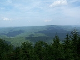
, one of the highest points in the state. Just north of US 250 on Shavers Mountain is Gaudineer Knob
, which provides scenic overviews of much of the Shavers Fork Mountain Complex. It is also home to the Gaudineer Scenic Area
, a protected stand of spruce
trees.
and Durbin
subdivision of the Chesapeake and Ohio Railway
opened, providing economic transport. By the 1930s, much of the land was completely denuded. This led to devastating floods and fires of the remaining trees. In the 1930s, reforestation of the land began in ernest through Civilian Conservation Corps
projects of the Monongahela National Forest
.
Randolph County, West Virginia
As of the census of 2000, there were 28,262 people, 11,072 households, and 7,661 families residing in the county. The population density was 27 people per square mile . There were 13,478 housing units at an average density of 13 per square mile...
, Pocahontas County
Pocahontas County, West Virginia
As of the census of 2000, there were 9,131 people, 835 households, and 527 families residing in the county. The population density was 10 people per square mile . There were 7,594 housing units at an average density of 8 per square mile...
, and Tucker County
Tucker County, West Virginia
As of the census of 2000, there were 7,321 people, 3,052 households, and 2,121 families residing in the county. The population density was 18 people per square mile . There were 4,634 housing units at an average density of 11 per square mile...
in West Virginia
West Virginia
West Virginia is a state in the Appalachian and Southeastern regions of the United States, bordered by Virginia to the southeast, Kentucky to the southwest, Ohio to the northwest, Pennsylvania to the northeast and Maryland to the east...
, USA. Much of the land surrounding the river and its adjacent mountains is protected by Monongahela National Forest
Monongahela National Forest
The Monongahela National Forest is a national forest located in the Allegheny Mountains of eastern West Virginia, USA. It protects over of federally-owned land within a proclamation boundary that includes much of the Potomac Highlands Region and portions of 10 counties.The MNF includes some...
including about 20000 acres (80.9 km²) of designated wilderness.
Cheat Mountain
Cheat MountainCheat Mountain
Cheat Mountain is an exceptionally high and rugged ridge situated in the Allegheny Mountains of eastern West Virginia, USA. It is about long and more than five miles wide at its widest. Its highest point is at its southernmost end at Thorny Flat, which has an elevation of...
follows the western side of Shavers Fork from Thorny Flat in Pocahontas County
Pocahontas County, West Virginia
As of the census of 2000, there were 9,131 people, 835 households, and 527 families residing in the county. The population density was 10 people per square mile . There were 7,594 housing units at an average density of 8 per square mile...
north to near Parsons
Parsons, West Virginia
The town of Parsons is the county seat of Tucker County, West Virginia, in the United States. The population was 1,463 at the 2000 census. The mayor of Parsons is Dorothy Judy and the city administrator is Jason Myers...
in Tucker County
Tucker County, West Virginia
As of the census of 2000, there were 7,321 people, 3,052 households, and 2,121 families residing in the county. The population density was 18 people per square mile . There were 4,634 housing units at an average density of 11 per square mile...
. This ridge separates the Shavers Fork valley from the Tygart Valley River
Tygart Valley River
The Tygart Valley River — also known as the Tygart River — is a principal tributary of the Monongahela River, approximately long, in east-central West Virginia, USA...
valley.
Its high point is at Thorny Flat. Another notable point is where the Staunton-Parkersburg Turnpike (present-day U.S. Route 250
U.S. Route 250
U.S. Route 250 is a route of the United States Numbered Highway System, and is a spur of U.S. Route 50. It currently runs for from Sandusky, Ohio to Richmond, Virginia. It passes through the states of Virginia, West Virginia, and Ohio. It goes through the cities of Richmond, Virginia,...
) crosses Cheat Mountain at White Top
White Top
White Top is a knob and spur of Cheat Mountain in southeastern Randolph County, West Virginia, USA. Sitting at an elevation of , it is located just west of the Shavers Fork of Cheat River and Cheat Bridge. While White Top was originally crossed by the Staunton-Parkersburg Turnpike, modern-day U.S...
. During the American Civil War
American Civil War
The American Civil War was a civil war fought in the United States of America. In response to the election of Abraham Lincoln as President of the United States, 11 southern slave states declared their secession from the United States and formed the Confederate States of America ; the other 25...
, it was home to the highest Union Army
Union Army
The Union Army was the land force that fought for the Union during the American Civil War. It was also known as the Federal Army, the U.S. Army, the Northern Army and the National Army...
fortification of the war.
Shavers and Back Allegheny Mountains
Shavers MountainShavers Mountain
Shavers Mountain, is a high and rugged ridge situated in the Allegheny Mountains of eastern West Virginia. It is about long, north to south, and several of its peaks exceed in elevation...
and Back Allegheny Mountain
Back Allegheny Mountain
Back Allegheny Mountain is a long mountain ridge in eastern West Virginia. It is part of the Shavers Fork Mountain Complex in the Allegheny Range of the Appalachians.- Geography :...
are part of the same structural ridge
Ridge
A ridge is a geological feature consisting of a chain of mountains or hills that form a continuous elevated crest for some distance. Ridges are usually termed hills or mountains as well, depending on size. There are several main types of ridges:...
that follows the eastern edge of Shavers Fork from Pocahontas County
Pocahontas County, West Virginia
As of the census of 2000, there were 9,131 people, 835 households, and 527 families residing in the county. The population density was 10 people per square mile . There were 7,594 housing units at an average density of 8 per square mile...
into Tucker County
Tucker County, West Virginia
As of the census of 2000, there were 7,321 people, 3,052 households, and 2,121 families residing in the county. The population density was 18 people per square mile . There were 4,634 housing units at an average density of 11 per square mile...
. North of U.S. Route 250
U.S. Route 250
U.S. Route 250 is a route of the United States Numbered Highway System, and is a spur of U.S. Route 50. It currently runs for from Sandusky, Ohio to Richmond, Virginia. It passes through the states of Virginia, West Virginia, and Ohio. It goes through the cities of Richmond, Virginia,...
, the ridge is known as Shavers Mountain
Shavers Mountain
Shavers Mountain, is a high and rugged ridge situated in the Allegheny Mountains of eastern West Virginia. It is about long, north to south, and several of its peaks exceed in elevation...
; south, it is Back Allegheny Mountain
Back Allegheny Mountain
Back Allegheny Mountain is a long mountain ridge in eastern West Virginia. It is part of the Shavers Fork Mountain Complex in the Allegheny Range of the Appalachians.- Geography :...
. This ridge separates the Shavers Fork watershed, which eventually flows to the Monongahela River
Monongahela River
The Monongahela River is a river on the Allegheny Plateau in north-central West Virginia and southwestern Pennsylvania in the United States...
, from the Greenbrier River
Greenbrier River
The Greenbrier River is a tributary of the New River, long, in southeastern West Virginia, USA. Via the New, Kanawha and Ohio Rivers, it is part of the watershed of the Mississippi River, draining an area of...
watershed, which eventually enters the Kanawha River
Kanawha River
The Kanawha River is a tributary of the Ohio River, approximately 97 mi long, in the U.S. state of West Virginia. The largest inland waterway in West Virginia, it has formed a significant industrial region of the state since the middle of the 19th century.It is formed at the town of Gauley...
.
One notable high point on Back Allegheny Mountain is Bald Knob
Bald Knob
Bald Knob is the highest summit of Back Allegheny Mountain in Pocahontas County, West Virginia and is part of Cass Scenic Railroad State Park...
, one of the highest points in the state. Just north of US 250 on Shavers Mountain is Gaudineer Knob
Gaudineer Knob
Gaudineer Knob is a mountain summit on the Randolph/Pocahontas County line in eastern West Virginia, USA. It is the highest elevation of Shavers Mountain, a ridge of the Alleghenies, and is located about east of the town of Cheat Bridge...
, which provides scenic overviews of much of the Shavers Fork Mountain Complex. It is also home to the Gaudineer Scenic Area
Gaudineer Scenic Area
The Gaudineer Scenic Area is a scenic area and National Natural Landmark in the Monongahela National Forest . It is situated just north of Gaudineer Knob of Shavers Mountain on the border of Randolph and Pocahontas Counties, West Virginia, USA, about northwest of the town of...
, a protected stand of spruce
Spruce
A spruce is a tree of the genus Picea , a genus of about 35 species of coniferous evergreen trees in the Family Pinaceae, found in the northern temperate and boreal regions of the earth. Spruces are large trees, from tall when mature, and can be distinguished by their whorled branches and conical...
trees.
Other mountains
Several other neighboring mountains are frequently considered to be part of the Shavers Fork Mountain Complex.- Bickle KnobBickle KnobBickle Knob is a mountain summit located east of Elkins in Randolph County, West Virginia. Easily accessible during warm-weather months, Bickle Knob is also home to one of the few remaining observation towers in Monongahela National Forest....
- McGowan Mountain
- Elk Mountain
- Middle Mountain
History
Much of the Shavers Fork area was heavily timbered in the early 1900s after the Western Maryland RailwayWestern Maryland Railway
The Western Maryland Railway was an American Class I railroad which operated in Maryland, West Virginia, and Pennsylvania. It was primarily a coal hauling and freight railroad, with a small passenger train operation. The WM became part of the Chessie System in 1973 and ceased operating its lines...
and Durbin
Durbin, West Virginia
Durbin is a town in Pocahontas County, West Virginia, United States. The population was 262 at the 2000 census.-Geography:Durbin is situated in the northern part of Pocahontas County at the confluence of the East and West Forks of the Greenbrier River. It is thus the starting point of the...
subdivision of the Chesapeake and Ohio Railway
Chesapeake and Ohio Railway
The Chesapeake and Ohio Railway was a Class I railroad formed in 1869 in Virginia from several smaller Virginia railroads begun in the 19th century. Led by industrialist Collis P...
opened, providing economic transport. By the 1930s, much of the land was completely denuded. This led to devastating floods and fires of the remaining trees. In the 1930s, reforestation of the land began in ernest through Civilian Conservation Corps
Civilian Conservation Corps
The Civilian Conservation Corps was a public work relief program that operated from 1933 to 1942 in the United States for unemployed, unmarried men from relief families, ages 18–25. A part of the New Deal of President Franklin D...
projects of the Monongahela National Forest
Monongahela National Forest
The Monongahela National Forest is a national forest located in the Allegheny Mountains of eastern West Virginia, USA. It protects over of federally-owned land within a proclamation boundary that includes much of the Potomac Highlands Region and portions of 10 counties.The MNF includes some...
.
Climate
The mountains in this area, particularly the Cheat and Back Allegheny, are notorious for their bad weather, especially in winter. Both record lows and record snowfall for the state of West Virginia have occurred here. Terrible storms and bitter cold are the norm from November to April, although it has been known to snow on the highest summits as early as mid-September and as late as June 7. Freezing temperatures and frost have occurred during every month and rime ice accumulations are common above 4000 feet (1,219.2 m). As a rule of thumb, "if you don't like the weather, wait 10 minutes and it will change."See also
- Gaudineer Scenic AreaGaudineer Scenic AreaThe Gaudineer Scenic Area is a scenic area and National Natural Landmark in the Monongahela National Forest . It is situated just north of Gaudineer Knob of Shavers Mountain on the border of Randolph and Pocahontas Counties, West Virginia, USA, about northwest of the town of...
, including about 50 acres (202,343 m²) of virginOld growth forestAn old-growth forest is a forest that has attained great age , and thereby exhibits unique ecological features. An old growth forest has also usually reached a climax community...
red spruceRed SprucePicea rubens is a species of spruce native to eastern North America, ranging from eastern Quebec to Nova Scotia, and from New England south in the Adirondack Mountains and Appalachians to western North Carolina.-Physical description:...
forest remaining on part of Shavers MountainShavers MountainShavers Mountain, is a high and rugged ridge situated in the Allegheny Mountains of eastern West Virginia. It is about long, north to south, and several of its peaks exceed in elevation...
due to a surveying error - Laurel Fork North WildernessLaurel Fork North WildernessLaurel Fork North Wilderness is a U.S. Wilderness Area located in the Greenbrier Ranger District of Monongahela National Forest in West Virginia. The Wilderness protects high-elevation lands along Laurel Fork and is bordered by Middle Mountain to the west. It is a companion to Laurel Fork South...
and Laurel Fork South WildernessLaurel Fork South WildernessLaurel Fork South Wilderness is a U.S. Wilderness Area located in the Greenbrier Ranger District of Monongahela National Forest in West Virginia. The Wilderness protects high-elevation lands along Laurel Fork and is bordered by Middle Mountain to the west. It is a companion to Laurel Fork North...
, wilderness areas along Middle Mountain