
Gaudineer Scenic Area
Encyclopedia
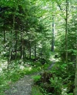
The Gaudineer Scenic Area (GSA) is a scenic area and National Natural Landmark
in the Monongahela National Forest
(MNF). It is situated just north of Gaudineer Knob
of Shavers Mountain
on the border of Randolph
and Pocahontas Counties
, West Virginia
, USA, about 5 miles (8 km) northwest of the town of Durbin
.
red spruce
forest. Trees in this section range up to 40 inches (101.6 cm) in diameter at chest height and are upwards of 300 years-old. The remaining 90 acres (364,217.4 m²) have only been subjected to selective timber harvesting, mostly for the task of removing broken limbs. The GSA contains—in addition to red spruce—excellent first and second-growth specimens of several native hardwoods, including red maple
, sugar maple
, yellow birch
, and beech
. Forest Service authorities estimate the total wood volume of the 140 acres (566,560.4 m²) tract at 1500000 board feet (3,539.6 m³).
. Maurice Brooks
described the circumstances whereby a portion of the virgin forest was spared in his classic book on Appalachian natural history:
The tract was eventually purchased by the Forest Service at the insistence of former MNF Supervisor Arthur A. Wood, who believed that future generations should know what an Appalachian spruce stand was like.
In October 1964 the Regional Forester designated this area as a Scenic Area and the Forest Service began to manage it as such. In December 1974 the GSA was designated a National Natural Landmark
for its exceptional value. In May 1983 it was registered by the Society of American Foresters
as an outstanding example of a vegetative community in a near natural condition dedicated for scientific and educational purposes.
National Natural Landmark
The National Natural Landmark program recognizes and encourages the conservation of outstanding examples of the natural history of the United States. It is the only natural areas program of national scope that identifies and recognizes the best examples of biological and geological features in...
in the Monongahela National Forest
Monongahela National Forest
The Monongahela National Forest is a national forest located in the Allegheny Mountains of eastern West Virginia, USA. It protects over of federally-owned land within a proclamation boundary that includes much of the Potomac Highlands Region and portions of 10 counties.The MNF includes some...
(MNF). It is situated just north of Gaudineer Knob
Gaudineer Knob
Gaudineer Knob is a mountain summit on the Randolph/Pocahontas County line in eastern West Virginia, USA. It is the highest elevation of Shavers Mountain, a ridge of the Alleghenies, and is located about east of the town of Cheat Bridge...
of Shavers Mountain
Shavers Mountain
Shavers Mountain, is a high and rugged ridge situated in the Allegheny Mountains of eastern West Virginia. It is about long, north to south, and several of its peaks exceed in elevation...
on the border of Randolph
Randolph County, West Virginia
As of the census of 2000, there were 28,262 people, 11,072 households, and 7,661 families residing in the county. The population density was 27 people per square mile . There were 13,478 housing units at an average density of 13 per square mile...
and Pocahontas Counties
Pocahontas County, West Virginia
As of the census of 2000, there were 9,131 people, 835 households, and 527 families residing in the county. The population density was 10 people per square mile . There were 7,594 housing units at an average density of 8 per square mile...
, West Virginia
West Virginia
West Virginia is a state in the Appalachian and Southeastern regions of the United States, bordered by Virginia to the southeast, Kentucky to the southwest, Ohio to the northwest, Pennsylvania to the northeast and Maryland to the east...
, USA, about 5 miles (8 km) northwest of the town of Durbin
Durbin, West Virginia
Durbin is a town in Pocahontas County, West Virginia, United States. The population was 262 at the 2000 census.-Geography:Durbin is situated in the northern part of Pocahontas County at the confluence of the East and West Forks of the Greenbrier River. It is thus the starting point of the...
.
Description
The GSA is located in the Greenbrier Ranger District of the MNF. It lies near the crest of Shavers Mountain immediately north of Gaudineer Knob, the mountain's highest peak at 4432 feet (1,350.9 m). The Scenic Area itself is at about 4000 feet (1,219.2 m). Its total land area is 140 acres (566,560.4 m²) and approximately 50 acres (202,343 m²) of the area is classified as virginOld growth forest
An old-growth forest is a forest that has attained great age , and thereby exhibits unique ecological features. An old growth forest has also usually reached a climax community...
red spruce
Red Spruce
Picea rubens is a species of spruce native to eastern North America, ranging from eastern Quebec to Nova Scotia, and from New England south in the Adirondack Mountains and Appalachians to western North Carolina.-Physical description:...
forest. Trees in this section range up to 40 inches (101.6 cm) in diameter at chest height and are upwards of 300 years-old. The remaining 90 acres (364,217.4 m²) have only been subjected to selective timber harvesting, mostly for the task of removing broken limbs. The GSA contains—in addition to red spruce—excellent first and second-growth specimens of several native hardwoods, including red maple
Red Maple
Acer rubrum , is one of the most common and widespread deciduous trees of eastern North America. It ranges from the Lake of the Woods on the border between Ontario and Minnesota, east to Newfoundland, south to near Miami, Florida, and southwest to east Texas...
, sugar maple
Sugar Maple
Acer saccharum is a species of maple native to the hardwood forests of northeastern North America, from Nova Scotia west to southern Ontario, and south to Georgia and Texas...
, yellow birch
Yellow Birch
Betula alleghaniensis , is a species of birch native to eastern North America, from Newfoundland to Nova Scotia, New Brunswick, southern Quebec and Ontario, and the southeast corner of Manitoba in Canada, west to Minnesota, and south in the Appalachian Mountains to northern Georgia.It is a...
, and beech
Beech
Beech is a genus of ten species of deciduous trees in the family Fagaceae, native to temperate Europe, Asia and North America.-Habit:...
. Forest Service authorities estimate the total wood volume of the 140 acres (566,560.4 m²) tract at 1500000 board feet (3,539.6 m³).
History
The area surrounding the GSA was thoroughly clear-cut between about 1900 and 1920 by lumbermen of the West Virginia Pulp and Paper Company, based at CassCass, West Virginia
Cass is an unincorporated census-designated place on the Greenbrier River in Pocahontas County, West Virginia, USA. As of the 2010 census, its population was 52...
. Maurice Brooks
Maurice Brooks
Maurice Graham Brooks was an American educator and naturalist whose name became synonymous with the natural history of Appalachia.-Biography:...
described the circumstances whereby a portion of the virgin forest was spared in his classic book on Appalachian natural history:
Some years before the Civil WarAmerican Civil WarThe American Civil War was a civil war fought in the United States of America. In response to the election of Abraham Lincoln as President of the United States, 11 southern slave states declared their secession from the United States and formed the Confederate States of America ; the other 25...
a speculating land company bought a tract of 69000 acres (279.2 km²) on the slope of Shavers Mountain. Their tract fronted for about seven miles (11 km) along the eastern side of the mountain. To survey and mark their holdings the company hired a crew of men who must have found rough going in this wilderness. The crew did a good job, but its chief forgot one thing – the fact that a compassCompassA compass is a navigational instrument that shows directions in a frame of reference that is stationary relative to the surface of the earth. The frame of reference defines the four cardinal directions – north, south, east, and west. Intermediate directions are also defined...
needle points to magnetic, not true northTrue northTrue north is the direction along the earth's surface towards the geographic North Pole.True geodetic north usually differs from magnetic north , and from grid north...
. In this area the angle of declinationMagnetic declinationMagnetic declination is the angle between magnetic north and true north. The declination is positive when the magnetic north is east of true north. The term magnetic variation is a synonym, and is more often used in navigation...
is about four degrees, a significant source of error on a seven-mile (11 km) front…. An experienced Virginia surveyor, in checking the data, discovered the error but said nothing about it. Presently, however, when the sale was being concluded and the deeds recorded, he brought the error to light, and under a sort of “doctrine of vacancy” claimed the wedge of land left by a corrected survey. His title was established, and he and his heirs found themselves owner of a seven-mile (11 km) strip of forest, aggregating almost 900 acres (3.6 km²). While timber above and below the wedge was cut, this narrow holding was undisturbed. Its thickest end, a fringe of tall spruces on the near horizon, is just east of Gaudineer Tower. From these trees came seed to produce a new forest, a happy result of a hundred-year-old mistake.
The tract was eventually purchased by the Forest Service at the insistence of former MNF Supervisor Arthur A. Wood, who believed that future generations should know what an Appalachian spruce stand was like.
In October 1964 the Regional Forester designated this area as a Scenic Area and the Forest Service began to manage it as such. In December 1974 the GSA was designated a National Natural Landmark
National Natural Landmark
The National Natural Landmark program recognizes and encourages the conservation of outstanding examples of the natural history of the United States. It is the only natural areas program of national scope that identifies and recognizes the best examples of biological and geological features in...
for its exceptional value. In May 1983 it was registered by the Society of American Foresters
Society of American Foresters
The Society of American Foresters is a scientific and educational 501 non-profit organization, representing the forestry profession in the United States of America...
as an outstanding example of a vegetative community in a near natural condition dedicated for scientific and educational purposes.
See also
- Shavers Fork Mountain Complex
- List of old growth forests
- List of National Natural Landmarks in West Virginia