
Serbian Carpathians
Encyclopedia

Central Serbia
Central Serbia , also referred to as Serbia proper , was the region of Serbia from 1945 to 2009. It included central parts of Serbia outside of the autonomous provinces of Kosovo and Vojvodina. The region of Central Serbia was not an administrative division of Serbia as such; it was under the...
Serbia
Serbia
Serbia , officially the Republic of Serbia , is a landlocked country located at the crossroads of Central and Southeast Europe, covering the southern part of the Carpathian basin and the central part of the Balkans...
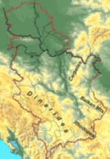
. It presents an extension of proper Carpathian Mountains
Carpathian Mountains
The Carpathian Mountains or Carpathians are a range of mountains forming an arc roughly long across Central and Eastern Europe, making them the second-longest mountain range in Europe...
across the Danube
Danube
The Danube is a river in the Central Europe and the Europe's second longest river after the Volga. It is classified as an international waterway....
, connecting them with the Balkan Mountains
Balkan Mountains
The Balkan mountain range is a mountain range in the eastern part of the Balkan Peninsula. The Balkan range runs 560 km from the Vrashka Chuka Peak on the border between Bulgaria and eastern Serbia eastward through central Bulgaria to Cape Emine on the Black Sea...
in the southeast. They stretch in north-south direction in the eastern Serbia
Serbia
Serbia , officially the Republic of Serbia , is a landlocked country located at the crossroads of Central and Southeast Europe, covering the southern part of the Carpathian basin and the central part of the Balkans...
, west of the Great Morava valley and east of the White Timok Valley and north of the Nišava Valley. The mountains are 800–1500 m high, and dominated by karst
KARST
Kilometer-square Area Radio Synthesis Telescope is a Chinese telescope project to which FAST is a forerunner. KARST is a set of large spherical reflectors on karst landforms, which are bowlshaped limestone sinkholes named after the Kras region in Slovenia and Northern Italy. It will consist of...
limestone
Limestone
Limestone is a sedimentary rock composed largely of the minerals calcite and aragonite, which are different crystal forms of calcium carbonate . Many limestones are composed from skeletal fragments of marine organisms such as coral or foraminifera....
geologic features.
Definitions
Under the strict definition (as defined by the Serbian Academy of Sciences and ArtsSerbian Academy of Sciences and Arts
The Serbian Academy of Sciences and Arts is the most prominent academic institution in Serbia today...
and adopted by the Carpathian Convention
Carpathian Convention
The Framework Convention on the Protection and Sustainable Development of the Carpathians is a framework type convention pursuing a comprehensive policy and cooperating in the protection and sustainable development of the Carpathians...
), Serbian part of the Carpathian Mountains
Carpathian Mountains
The Carpathian Mountains or Carpathians are a range of mountains forming an arc roughly long across Central and Eastern Europe, making them the second-longest mountain range in Europe...
covers only 732 km², or 0.35% of the total Carpathian area. That part encompasses the southern bank of the Iron Gate
Iron Gate
Iron Gate can refer to* Gates of Alexander, iron gates built by Alexander the Great* Iron Gates , a pass through the Bibans mountains in Algeria* Iron Gate Pass, a gorge in central Xinjiang, People's Republic of China...
and the area of Đerdap national park. In most other definitions, even that part is not included in the Carpathians, and they do not cross the Danube. The extreme points of so defined Carpathian area in Serbia are Tekija
Tekija (Kladovo)
Tekija is a village in the municipality of Kladovo in eastern Serbia. According to the 2002 census, the village has a population of 967 people....
44°43′N 22°28′E on north, 44°22′N 22°06′E on south, Golubac
Golubac
Golubac is a village and municipality in north-eastern Serbia, on the right side of the Danube river. It is bordered by Romania to the east, Veliko Gradište to the west and Kučevo to the south...
44°40′N 21°36′E on west and 44°39′N 22°33′E on east (Iron Gate dam). It covers northern rims of northern Kučaj, Šomrda, Liskovac, Veliki Greben and Miroč mountains, in municipalities of Golubac
Golubac
Golubac is a village and municipality in north-eastern Serbia, on the right side of the Danube river. It is bordered by Romania to the east, Veliko Gradište to the west and Kučevo to the south...
, Majdanpek
Majdanpek
Majdanpek is a town and municipality in Bor District of Serbia. According to 2011 census, the municipality of Majdanpek has a population of 18,179 people, while the town of Majdanpek has a population of 7,367....
and Kladovo
Kladovo
Kladovo is a town and municipality in the Bor District of eastern Serbia. It is situated on the right bank of the Danube river...
However, in Serbian geography, the epithet "Carpathian" is traditionally also given to the whole northern part of the Carpatho-Balkan arc, which connects the Carpathians proper with the Balkan Mountains
Balkan Mountains
The Balkan mountain range is a mountain range in the eastern part of the Balkan Peninsula. The Balkan range runs 560 km from the Vrashka Chuka Peak on the border between Bulgaria and eastern Serbia eastward through central Bulgaria to Cape Emine on the Black Sea...
. It refers to the following mountains:
- ŠomrdaŠomrdaŠomrda is a mountain in eastern Serbia, near the town of Lepenski Vir. Its highest peak has an altitude of 803 meters above sea level. Most of Šomrda is located in the Đerdap National Park.-External links:...
- LiškovacLiškovacLiškovac is a mountain in eastern Serbia, between towns of Majdanpek and Donji Milanovac. Its highest peak Veliki Liškovac has an altitude of 803 meters above sea level. Along with Miroč, Liškovac is part of the Iron Gate of the Danube river. It is located in the Đerdap national park....
- Veliki GrebenVeliki GrebenVeliki Greben is a mountain in eastern Serbia, near the town of Donji Milanovac. Its highest peak Crni vrh has an altitude of 656 meters above sea level. Veliki Greben extends in north-south direction, along the right bank of Porečka river to its confluence in Danube....
- MiročMiročMiroč is a mountain in eastern Serbia, between the towns of Donji Milanovac and Tekija. Its highest peak Štrbac has an altitude of above sea level. Along with Liškovac, it is part of the Iron Gate gorge of the Danube river...
- Homolje mountainsHomolje mountainsHomolje mountains is a mountain range in eastern Serbia. It lies in the region known as Homolje between towns of Žagubica on south and Kučevo on north. Its highest peaks are Štubej and Vranj . On the mountain, there is Orthodox monastery of Vitovnica...
(Homoljske planine) - Veliki KršVeliki KršVeliki Krš is a mountain in eastern Serbia, near the city of Bor. Its highest peak Veliki krš has an altitude of 1148 meters above sea level. Like nearby Mali Krš and Stol, it is dominated by karst formations, and they are collectively known as "Gornjanski kras". Veliki Krš has a elongated...
- Mali KršMali KršMali Krš is a mountain in eastern Serbia. Its highest peak, Garvan, has 929 metres above sea level. While not particularly rugged, Mali Krš is remote, hidden between nearby mountains of Liškovac, Veliki Krš and Homolje mountains. Like nearby Veliki Krš and Stol, Mali Krš is dominated by karst...
- StolStol (Serbia)Stol is a mountain in eastern Serbia, near the town of Bor. Its highest peak has an altitude of 1155 meters above sea level. Like nearby Veliki Krš and Mali Krš, Stol has a number of pronounced karst formations. There is a mountain hut with around 35 beds, maintained by the mountaineering...
- Deli JovanDeli JovanDeli Jovan is a mountain in eastern Serbia, near the town of Negotin. Its highest peak Crni vrh has an altitude of 1136 meters above sea level. On the top of the mountain, there is a TV tower....
- BeljanicaBeljanicaBabička Gora is a mountain in Homolje region in eastern Serbia, near the town of Žagubica. Its highest peak has an altitude of 1339 metres above sea level....
- Kučaj mountains (Kučajske planine)
- RtanjRtanjRtanj is a village in the municipality of Boljevac, Serbia. According to the 2002 census, the village has a population of 182 people.-References:...
- TupižnicaTupižnicaTupižnica is a mountain in eastern Serbia, between towns of Boljevac, Zaječar and Knjaževac. Its highest peaks, Bučanski kamen and Glogovački vrh have an altitude of 1160 metres each....
- DevicaDevicaDevica is a mountain in eastern Serbia, near the town of Sokobanja. Its highest peak, Čapljinac has an altitude of 1187 metres above sea level...
- OzrenOzren (Sokobanja)Ozren is a mountain in central Serbia, near the town of Sokobanja. Its highest peak Leskovik has an altitude of 1174 meters above sea level. Ozren is well-forested and attractive as a picnic ground for visitors to the Soko spa....
There are incentives to incorporate the whole wider Serbian Carpathian region into the framework of the Carpathian Convention
Carpathian Convention
The Framework Convention on the Protection and Sustainable Development of the Carpathians is a framework type convention pursuing a comprehensive policy and cooperating in the protection and sustainable development of the Carpathians...
. Serbia ratified the Convention in November 2007.
Geology
The entire part of Serbia east of the Great and South Morava rivers is referred to as "Carpatho-Balkan arc" in geotectonic terminology. The region is composed of rocks of ProterozoicProterozoic
The Proterozoic is a geological eon representing a period before the first abundant complex life on Earth. The name Proterozoic comes from the Greek "earlier life"...
to Quaternary
Quaternary
The Quaternary Period is the most recent of the three periods of the Cenozoic Era in the geologic time scale of the ICS. It follows the Neogene Period, spanning 2.588 ± 0.005 million years ago to the present...
age. Limestones and dolomites (in a lesser extent) of Jurassic
Jurassic
The Jurassic is a geologic period and system that extends from about Mya to Mya, that is, from the end of the Triassic to the beginning of the Cretaceous. The Jurassic constitutes the middle period of the Mesozoic era, also known as the age of reptiles. The start of the period is marked by...
(J2, J3) and Lower Cretaceous (K1+2, K3+4) age whose thickness can be more than 1,000 m. The structures are generally oriented in north-south direction, which bend on northern and southern parts, forming a C-shaped arc.
Though those mountains are related to the Carpathians from the geological point of view, they have been included to them by the scientists only at the end of the 20. century. In the past, those mountains were included by mistake to the Balkan mountains
Balkan Mountains
The Balkan mountain range is a mountain range in the eastern part of the Balkan Peninsula. The Balkan range runs 560 km from the Vrashka Chuka Peak on the border between Bulgaria and eastern Serbia eastward through central Bulgaria to Cape Emine on the Black Sea...
.
Demographics
Eastern Serbia is one of most sparsely populated areas of the Balkans. A large portion of the population is engaged in nomadic sheep-breeding. The population is mixed of SerbsSerbs
The Serbs are a South Slavic ethnic group of the Balkans and southern Central Europe. Serbs are located mainly in Serbia, Montenegro and Bosnia and Herzegovina, and form a sizable minority in Croatia, the Republic of Macedonia and Slovenia. Likewise, Serbs are an officially recognized minority in...
and Vlachs. It is underdeveloped, with sparse infrastructure and long distances between towns. The region is subject to further depopulation: between censuses of 1991 and 2002, municipalities of Bor
Bor, Serbia
Bor is a town and municipality located in eastern Serbia, with one of the largest copper mines in Europe and it has been a mining centre since 1904, when a French company began operations there. It is the administrative center of the Bor District of Serbia...
and Majdanpek
Majdanpek
Majdanpek is a town and municipality in Bor District of Serbia. According to 2011 census, the municipality of Majdanpek has a population of 18,179 people, while the town of Majdanpek has a population of 7,367....
lost 3,500 residents each, Negotin
Negotin
Negotin is a town and municipality in the Bor District of north-eastern Central Serbia. It is situated near the borders between Serbia, Romania and Bulgaria. It is the judicial center of the Bor District. The population of the town is 16,716 while municipality has 36,879.-Name:The etymology of the...
lost 5,500, Zaječar
Zajecar
Zaječar is a city and municipality in the eastern part of Serbia. According to the 2011 census the town has a population of 36,830, and its coordinates are 43.91° North, 22.30° East...
lost 5000, and Knjaževac
Knjaževac
Knjaževac is a town and municipality situated in the eastern part of Serbia bordering the Republic of Bulgaria and is part of Timočka Krajina region. It is found between the latitudes of 43°20' and 43°45' north and between the longitudes 22°11' and 22°41' east. The town is situated between three...
6,500.