
Schuylkill Canal
Encyclopedia
Schuylkill Canal is the common, but technically inaccurate, name for the Schuylkill Navigation, a 19th-century commercial waterway in and along the Schuylkill River
in the U.S. state
of Pennsylvania
. The "canal" was actually a system of interconnected man-made canal
s and slack-water pools in the river, which is called a navigation. The Schuylkill Navigation System opened in 1825 to provide transportation and water power. At the time, the river was the cheapest and most efficient method of transporting bulk cargo. As a result of this improved transportation, anthracite coal
-mining grew as the major source of industry between Pottsville
and Eastern markets. Mules pulled barges of coal from Port Carbon
to Pottsville; to the ports of Philadelphia
; and, continuing through additional waterways, to New York City
markets.
The canal eventually declined due to the rise of rail transport
, and was almost completely filled in the 1950s. The two remaining watered reaches are now used for recreation.
in the anthracite coal fields or the Coal Region
of Pottsville. Combining 62 miles (100 km) of separate canals, often referred to as "reaches", with 46 miles (74 km) of slack water pools, the Schuylkill Navigation used 92 lift locks to overcome a difference of 588 feet (179 m) in elevation between its terminal points. The Union Canal
, built between 1821 and 1828, connected with the Schuylkill Canal at Reading
; the two canals combined to make a water link between Philadelphia and the Susquehanna River at Middletown
. This route competed with and became secondary to the east–west divisions of the Pennsylvania Canal
on the Main Line of Public Works
between Philadelphia, Harrisburg, and Pittsburgh. The Schuylkill Canal also featured the first transportation tunnel in America
. The Auburn Tunnel
, a 450 foot (137 m) bore through a hill near Auburn
, was completed in 1821, but due to increased traffic, canal modifications turned it into an open-cut by 1857.
 Due to its ability to transport bulk cargoes and provide water power, the Schuylkill Navigation transformed the towns of Reading
, Norristown
, and Pottsville into early manufacturing centers. By using the Delaware River
and the Delaware and Raritan Canal, manufactured products and anthracite from the Schuylkill Valley could also reach New York Harbor
. The Schuylkill Navigation system quickly assumed a monopoly
position in the transportation of anthracite coal from the coal mines of Schuylkill County to Philadelphia. By 1841 the Schuylkill Navigation was annually transporting over 737,517 tons of cargo. However, in 1841 the Philadelphia and Reading Railroad was completed as a competing means of transporting coal from the Schuylkill anthracite fields to Philadelphia. A rivalry between these two forms of transportation soon developed.
. In 1850 a price-fixing arrangement with the railroad stabilized prices for the transportation of anthracite. This decade was the Schuylkill Navigation's most prosperous period, transporting 1,700,000 tons of cargo during the peak year of 1859. However, in that same year the Philadelphia and Reading Railroad carried over 2,500,000 tons.
, Schuylkill boats were denied access to this important New Jersey
waterway. As a result, traffic on the Schuylkill decreased rapidly. Adding insult to injury, the PRR itself invaded the Schuylkill's territory with the construction of its Schuylkill Branch in the mid-1880s. By 1890 only 144,994 tons of cargo passed through the Schuylkill Navigation. The Schuylkill Navigation was also greatly hindered by the problems of coal silt deposits which made its upper sections almost unusable. By 1891 the portion of Navigation above Port Clinton
was abandoned. By 1904 the anthracite traffic had almost completely ceased, and after 1913 only an occasional cargo passed between Port Clinton and Philadelphia. Excursion vessels and pleasure boating remained active on the Schuylkill Navigation until most of the canals were filled by the Commonwealth of Pennsylvania
during 1947–1979 in efforts to remove coal silt
from the Schuylkill River.
. The new canal connected the slackwater pool of the Schuylkill Canal above the Black Rock Dam
to Phoenixville. This canal paralleled the top end of the Oakes Reach, on the opposite side or the river. While the Chester County Canal was initially built to provide water power to the mill, in 1847 it carried scheduled passenger service between Phoenixville and Norristown
. The spring freshet
of 1869 destroyed the mill "and very much injured the canal and its locks."
and Mont Clare
and the 1 miles (1.6 km) reach in Manayunk
. Ruins and remnants of the canals structure are still visible along its length. Many of the locks chambers still exist but are buried to varying degrees. Some of the locktender's houses still exist. Even if filled in, the canal's presence in may river communities is remembered by several Canal Streets.
Leesport
has a restored Locktender's house on E. Wall Street. The adjacent lock is filled in, but the SW corner and top of the chamber are visible. Near Gibraltar
, the Allegheny Creek Aqueduct still exists along with a drained section of the canal prism. The Aqueduct is on the National Register of Historic Places.
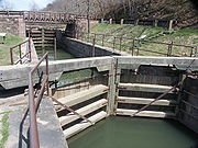
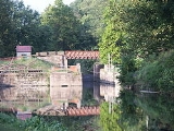
 The head of the Oakes Reach is at the Black Rock Dam
(Dam #26), near Mont Clare. The canal passes through the dam structure at Lock #60. The volunteer Schuylkill Canal Association
has restored Lock 60 to operating condition http://www.schuylkillcanal.com/restoration/index.html. The nearby locktender's house has also been restored http://www.schuylkillcanal.com/about/lockhouse.html. The Reach runs under Pennsylvania Route 29
in Mont Clare, directly across the river from Phoenixville
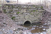
, then through Port Providence. An impounding basin from the silt removal project cuts the canal after Longford Road and the final mile of the Reach, has been filled in. An old stone aqueduct
, that carried the Canal over Crossman's Run, and the outlet lock tender's house are still existent; but Lock 61, Brower's Lock, was filled in.
This reach is named for Thomas Oakes
, chief engineer of the Schuylkill Navigation Company. The Oakes Reach canal, locks, locktenders' houses, Black Rock Dam, and the slackwater pool extending up to the Pennsylvania Route 113
bridge form the "Schuylkill Navigation Canal, Oakes Reach Section" historic district
.
, which is facing development pressures. At the downstream end of this reach, the canal runs through Manayunk and returns to the river via Locks 69 & 70. All three lock structures still exist.
(SRT) now overlays portions of the canal route. In Manayunk, the Trail was constructed across the canal from the towpath. (The Reading railroad built a freight spur on the canal towpath. That railroad is still served by Norfolk Southern).
In 2008 the extension of the Schuylkill River Trail from the Perkiomen Creek
to Longford Road in Oaks opened. This length of the Trail makes use of the general course of the filled portion of the Oakes Reach and originally used the old canal aqueduct to cross Crossman's Run. On 14 February 2008, a meeting was held to announce the survey work for the extension of the Schuylkill River Trail along the towpath of the watered portion of the Oakes Reach. It was expected that the towpath restoration itself would commence around March 2009. However this work was suspended due to budget constraints.
Schuylkill River
The Schuylkill River is a river in Pennsylvania. It is a designated Pennsylvania Scenic River.The river is about long. Its watershed of about lies entirely within the state of Pennsylvania. The source of its eastern branch is in the Appalachian Mountains at Tuscarora Springs, near Tamaqua in...
in the U.S. state
U.S. state
A U.S. state is any one of the 50 federated states of the United States of America that share sovereignty with the federal government. Because of this shared sovereignty, an American is a citizen both of the federal entity and of his or her state of domicile. Four states use the official title of...
of Pennsylvania
Pennsylvania
The Commonwealth of Pennsylvania is a U.S. state that is located in the Northeastern and Mid-Atlantic regions of the United States. The state borders Delaware and Maryland to the south, West Virginia to the southwest, Ohio to the west, New York and Ontario, Canada, to the north, and New Jersey to...
. The "canal" was actually a system of interconnected man-made canal
Canal
Canals are man-made channels for water. There are two types of canal:#Waterways: navigable transportation canals used for carrying ships and boats shipping goods and conveying people, further subdivided into two kinds:...
s and slack-water pools in the river, which is called a navigation. The Schuylkill Navigation System opened in 1825 to provide transportation and water power. At the time, the river was the cheapest and most efficient method of transporting bulk cargo. As a result of this improved transportation, anthracite coal
Coal
Coal is a combustible black or brownish-black sedimentary rock usually occurring in rock strata in layers or veins called coal beds or coal seams. The harder forms, such as anthracite coal, can be regarded as metamorphic rock because of later exposure to elevated temperature and pressure...
-mining grew as the major source of industry between Pottsville
Pottsville, Pennsylvania
Pottsville is the only city in and the county seat of Schuylkill County, Pennsylvania, United States. The population was 15,549 at the 2000 census. The city lies along the west bank of the Schuylkill River, north-west of Philadelphia...
and Eastern markets. Mules pulled barges of coal from Port Carbon
Port Carbon, Pennsylvania
Port Carbon is a borough of Schuylkill County, Pennsylvania, two miles northeast of Pottsville, Pa. It is in a coal-mining area; in the past, ironworks had been a feature of the borough. In 1900, 2,168 people lived here; in 1910, 2,678 people were inhabitants of Port Carbon...
to Pottsville; to the ports of Philadelphia
Philadelphia, Pennsylvania
Philadelphia is the largest city in the Commonwealth of Pennsylvania and the county seat of Philadelphia County, with which it is coterminous. The city is located in the Northeastern United States along the Delaware and Schuylkill rivers. It is the fifth-most-populous city in the United States,...
; and, continuing through additional waterways, to New York City
New York City
New York is the most populous city in the United States and the center of the New York Metropolitan Area, one of the most populous metropolitan areas in the world. New York exerts a significant impact upon global commerce, finance, media, art, fashion, research, technology, education, and...
markets.
The canal eventually declined due to the rise of rail transport
Rail transport
Rail transport is a means of conveyance of passengers and goods by way of wheeled vehicles running on rail tracks. In contrast to road transport, where vehicles merely run on a prepared surface, rail vehicles are also directionally guided by the tracks they run on...
, and was almost completely filled in the 1950s. The two remaining watered reaches are now used for recreation.
History
The Schuylkill Navigation Company was chartered in 1815 to build a series of navigation improvements in the Schuylkill River. A waterway of 108 miles (174 km) was completed in 1827 linking Philadelphia to Port CarbonPort Carbon, Pennsylvania
Port Carbon is a borough of Schuylkill County, Pennsylvania, two miles northeast of Pottsville, Pa. It is in a coal-mining area; in the past, ironworks had been a feature of the borough. In 1900, 2,168 people lived here; in 1910, 2,678 people were inhabitants of Port Carbon...
in the anthracite coal fields or the Coal Region
Coal Region
The Coal Region is a term used to refer to an area of Northeastern Pennsylvania in the central Appalachian Mountains comprising Lackawanna, Luzerne, Columbia, Carbon, Schuylkill, Northumberland, and the extreme northeast corner of Dauphin counties....
of Pottsville. Combining 62 miles (100 km) of separate canals, often referred to as "reaches", with 46 miles (74 km) of slack water pools, the Schuylkill Navigation used 92 lift locks to overcome a difference of 588 feet (179 m) in elevation between its terminal points. The Union Canal
Union Canal (Pennsylvania)
The Union Canal was a towpath canal that existed in southeastern Pennsylvania in the United States during the 19th century. First proposed in 1690 to connect Philadelphia with the Susquehanna River, it ran approximately 75 mi from Middletown on the Susquehanna below Harrisburg to Reading on...
, built between 1821 and 1828, connected with the Schuylkill Canal at Reading
Reading, Pennsylvania
Reading is a city in southeastern Pennsylvania, USA, and seat of Berks County. Reading is the principal city of the Greater Reading Area and had a population of 88,082 as of the 2010 census, making it the fifth most populated city in the state after Philadelphia, Pittsburgh, Allentown and Erie,...
; the two canals combined to make a water link between Philadelphia and the Susquehanna River at Middletown
Middletown, Pennsylvania
Middletown is the name of more than one location in the U.S. state of Pennsylvania:*Middletown, Dauphin County, Pennsylvania: 17057, of the Harrisburg metropolitan area*Middletown, Northampton County, Pennsylvania: 18017...
. This route competed with and became secondary to the east–west divisions of the Pennsylvania Canal
Pennsylvania Canal
Pennsylvania Canal refers generally to a complex system of canals, dams, locks, tow paths, aqueducts, and other infrastructure including, in some cases, railroads in Pennsylvania...
on the Main Line of Public Works
Main Line of Public Works
The Main Line of Public Works was a railroad and canal system built by the Commonwealth of Pennsylvania in the 19th century. It ran from Philadelphia west through Harrisburg and across the state to Pittsburgh and connected with other divisions of the Pennsylvania Canal...
between Philadelphia, Harrisburg, and Pittsburgh. The Schuylkill Canal also featured the first transportation tunnel in America
United States
The United States of America is a federal constitutional republic comprising fifty states and a federal district...
. The Auburn Tunnel
Auburn Tunnel
Auburn Tunnel was a 19th century canal tunnel built for the Schuylkill Canal, near Auburn, Pennsylvania. Auburn Tunnel was the first transportation tunnel built in the United States....
, a 450 foot (137 m) bore through a hill near Auburn
Auburn, Pennsylvania
There is also an Auburn Township in Pennsylvania.Auburn is a borough in Schuylkill County, Pennsylvania, USA. The population was 839 at the 2000 census.-Geography:Auburn is located at ....
, was completed in 1821, but due to increased traffic, canal modifications turned it into an open-cut by 1857.
Reading, Pennsylvania
Reading is a city in southeastern Pennsylvania, USA, and seat of Berks County. Reading is the principal city of the Greater Reading Area and had a population of 88,082 as of the 2010 census, making it the fifth most populated city in the state after Philadelphia, Pittsburgh, Allentown and Erie,...
, Norristown
Norristown, Pennsylvania
Norristown is a municipality in Montgomery County, Pennsylvania, northwest of the city limits of Philadelphia, on the Schuylkill River. The population was 34,324 as of the 2010 census. It is the county seat of Montgomery County...
, and Pottsville into early manufacturing centers. By using the Delaware River
Delaware River
The Delaware River is a major river on the Atlantic coast of the United States.A Dutch expedition led by Henry Hudson in 1609 first mapped the river. The river was christened the South River in the New Netherland colony that followed, in contrast to the North River, as the Hudson River was then...
and the Delaware and Raritan Canal, manufactured products and anthracite from the Schuylkill Valley could also reach New York Harbor
New York Harbor
New York Harbor refers to the waterways of the estuary near the mouth of the Hudson River that empty into New York Bay. It is one of the largest natural harbors in the world. Although the U.S. Board of Geographic Names does not use the term, New York Harbor has important historical, governmental,...
. The Schuylkill Navigation system quickly assumed a monopoly
Monopoly
A monopoly exists when a specific person or enterprise is the only supplier of a particular commodity...
position in the transportation of anthracite coal from the coal mines of Schuylkill County to Philadelphia. By 1841 the Schuylkill Navigation was annually transporting over 737,517 tons of cargo. However, in 1841 the Philadelphia and Reading Railroad was completed as a competing means of transporting coal from the Schuylkill anthracite fields to Philadelphia. A rivalry between these two forms of transportation soon developed.
Competition with the railroad
By 1845 the railroad was able to haul three times as much anthracite to Philadelphia each year as the Schuylkill Navigation. To counter this threat, the Schuylkill Navigation Company began a major expansion program. By 1847 the canals had been enlarged to allow the passage of boats carrying 230 tons of coalCoal
Coal is a combustible black or brownish-black sedimentary rock usually occurring in rock strata in layers or veins called coal beds or coal seams. The harder forms, such as anthracite coal, can be regarded as metamorphic rock because of later exposure to elevated temperature and pressure...
. In 1850 a price-fixing arrangement with the railroad stabilized prices for the transportation of anthracite. This decade was the Schuylkill Navigation's most prosperous period, transporting 1,700,000 tons of cargo during the peak year of 1859. However, in that same year the Philadelphia and Reading Railroad carried over 2,500,000 tons.
Decline
During the 1860s the canal entered a period of decline. In 1869 it was damaged by a flood. Surrendering to the competition in 1870, the Schuylkill Navigation Company leased its waterway to the Philadelphia and Reading Railroad for a period of 110 years. Under the railroad's control, the Schuylkill Navigation continued to decline. Since the Delaware and Raritan Canal was owned by the competing Pennsylvania RailroadPennsylvania Railroad
The Pennsylvania Railroad was an American Class I railroad, founded in 1846. Commonly referred to as the "Pennsy", the PRR was headquartered in Philadelphia, Pennsylvania....
, Schuylkill boats were denied access to this important New Jersey
New Jersey
New Jersey is a state in the Northeastern and Middle Atlantic regions of the United States. , its population was 8,791,894. It is bordered on the north and east by the state of New York, on the southeast and south by the Atlantic Ocean, on the west by Pennsylvania and on the southwest by Delaware...
waterway. As a result, traffic on the Schuylkill decreased rapidly. Adding insult to injury, the PRR itself invaded the Schuylkill's territory with the construction of its Schuylkill Branch in the mid-1880s. By 1890 only 144,994 tons of cargo passed through the Schuylkill Navigation. The Schuylkill Navigation was also greatly hindered by the problems of coal silt deposits which made its upper sections almost unusable. By 1891 the portion of Navigation above Port Clinton
Port Clinton, Pennsylvania
Port Clinton is a borough in Schuylkill County, Pennsylvania, United States. The population was 288 at the 2000 census.-Geography:Port Clinton is located at ....
was abandoned. By 1904 the anthracite traffic had almost completely ceased, and after 1913 only an occasional cargo passed between Port Clinton and Philadelphia. Excursion vessels and pleasure boating remained active on the Schuylkill Navigation until most of the canals were filled by the Commonwealth of Pennsylvania
Pennsylvania
The Commonwealth of Pennsylvania is a U.S. state that is located in the Northeastern and Mid-Atlantic regions of the United States. The state borders Delaware and Maryland to the south, West Virginia to the southwest, Ohio to the west, New York and Ontario, Canada, to the north, and New Jersey to...
during 1947–1979 in efforts to remove coal silt
Silt
Silt is granular material of a size somewhere between sand and clay whose mineral origin is quartz and feldspar. Silt may occur as a soil or as suspended sediment in a surface water body...
from the Schuylkill River.
Chester County Canal
The Chester County Canal, also known as the Phoenixville Branch Canal, was an addition to the Navigation built by the Schuylkill Navigation Company in 1828 to provide water power to a new nail works in PhoenixvillePhoenixville, Pennsylvania
Phoenixville is a borough in Chester County, Pennsylvania, United States, northwest of Philadelphia, at the junction of French Creek with the Schuylkill River. The population is 16,440 as of the 2010 Census.- History :...
. The new canal connected the slackwater pool of the Schuylkill Canal above the Black Rock Dam
Black Rock Dam (Schuylkill River)
The Black Rock Dam is a low head dam in the Schuylkill River. Originally constructed as a stone filled, timber crib dam in the early 19th century by the Schuylkill Navigation Company, the dam was one of dozens built to create a slack water pools for the Schuylkill Navigation System...
to Phoenixville. This canal paralleled the top end of the Oakes Reach, on the opposite side or the river. While the Chester County Canal was initially built to provide water power to the mill, in 1847 it carried scheduled passenger service between Phoenixville and Norristown
Norristown, Pennsylvania
Norristown is a municipality in Montgomery County, Pennsylvania, northwest of the city limits of Philadelphia, on the Schuylkill River. The population was 34,324 as of the 2010 census. It is the county seat of Montgomery County...
. The spring freshet
Freshet
A freshet can refer to one of two things:* A flood resulting from heavy rain or a spring thaw. Whereas heavy rain often causes a flash flood, a spring thaw event is generally a more incremental process, depending upon local climate and topography...
of 1869 destroyed the mill "and very much injured the canal and its locks."
The Navigation in the present day
While many of the dams remain, there are only two watered stretches of the canal still in existence. Some 2.5 miles (4 km) of the original 3.5 miles (5.6 km) long Oakes Reach between OaksOaks, Pennsylvania
Oaks is a village located in Upper Providence Township, Montgomery County, Pennsylvania, 18 miles northwest of Philadelphia. Its boundaries are defined in large part by the village's position at the junction of Perkiomen Creek and the Schuylkill River.-History:The two waterways defined much of the...
and Mont Clare
Mont Clare, Pennsylvania
Mont Clare is a village in Upper Providence Township, Montgomery County, Pennsylvania, USA. The village is located on the left bank of the Schuylkill River, opposite Phoenixville, at the site of the former Jacobs' ford. Mont Clare hosts the only functional lock and one of only two remaining...
and the 1 miles (1.6 km) reach in Manayunk
Manayunk, Philadelphia, Pennsylvania
Manayunk is a neighborhood in the northwestern section of the city of Philadelphia, Pennsylvania in the United States. Located on the banks of the Schuylkill River, it contains the first canal begun in the United States . The area's name comes from the language of the Lenape Indians...
. Ruins and remnants of the canals structure are still visible along its length. Many of the locks chambers still exist but are buried to varying degrees. Some of the locktender's houses still exist. Even if filled in, the canal's presence in may river communities is remembered by several Canal Streets.
Leesport
Leesport, Pennsylvania
Leesport is a borough in Berks County, Pennsylvania, United States. The population was 1,805 at the 2000 census.-Geography:Leesport is located at ....
has a restored Locktender's house on E. Wall Street. The adjacent lock is filled in, but the SW corner and top of the chamber are visible. Near Gibraltar
Gibraltar, Pennsylvania
Gibraltar is a locality in northern Robeson Township in southern Berks County. It is four miles from Birdsboro and 6.4 miles from downtown Reading. It is served by the Twin Valley School District and is across the Schuylkill River from Exeter....
, the Allegheny Creek Aqueduct still exists along with a drained section of the canal prism. The Aqueduct is on the National Register of Historic Places.
Oakes Reach
Black Rock Dam (Schuylkill River)
The Black Rock Dam is a low head dam in the Schuylkill River. Originally constructed as a stone filled, timber crib dam in the early 19th century by the Schuylkill Navigation Company, the dam was one of dozens built to create a slack water pools for the Schuylkill Navigation System...
(Dam #26), near Mont Clare. The canal passes through the dam structure at Lock #60. The volunteer Schuylkill Canal Association
Schuylkill Canal Association
The Schuylkill Canal Association is a non-governmental organization that maintains the Oakes Reach and Lock #60 of the Schuylkill Canal as a public recreation area and historical site...
has restored Lock 60 to operating condition http://www.schuylkillcanal.com/restoration/index.html. The nearby locktender's house has also been restored http://www.schuylkillcanal.com/about/lockhouse.html. The Reach runs under Pennsylvania Route 29
Pennsylvania Route 29
Pennsylvania Route 29 is a 118 mile long north–south state highway that runs through most of eastern Pennsylvania. The route currently exists in two segments, a southern segment and a northern segment. The southernmost terminus of the designation is at U.S. Route 30 in Malvern...
in Mont Clare, directly across the river from Phoenixville
Phoenixville, Pennsylvania
Phoenixville is a borough in Chester County, Pennsylvania, United States, northwest of Philadelphia, at the junction of French Creek with the Schuylkill River. The population is 16,440 as of the 2010 Census.- History :...
, then through Port Providence. An impounding basin from the silt removal project cuts the canal after Longford Road and the final mile of the Reach, has been filled in. An old stone aqueduct
Aqueduct
An aqueduct is a water supply or navigable channel constructed to convey water. In modern engineering, the term is used for any system of pipes, ditches, canals, tunnels, and other structures used for this purpose....
, that carried the Canal over Crossman's Run, and the outlet lock tender's house are still existent; but Lock 61, Brower's Lock, was filled in.
This reach is named for Thomas Oakes
Thomas Oakes (engineer)
Thomas Oakes was the Chief Engineer of the Schuylkill Navigation Company. He was responsible for the design and early construction of the Navigation's Schuylkill River canals in the early 19th century...
, chief engineer of the Schuylkill Navigation Company. The Oakes Reach canal, locks, locktenders' houses, Black Rock Dam, and the slackwater pool extending up to the Pennsylvania Route 113
Pennsylvania Route 113
Pennsylvania Route 113 is a long state route in eastern Pennsylvania. The southern terminus of the route is at U.S. Route 30 Business in Downingtown. Its northern terminus is at Pennsylvania Route 611 in Tinicum Township...
bridge form the "Schuylkill Navigation Canal, Oakes Reach Section" historic district
Historic district (United States)
In the United States, a historic district is a group of buildings, properties, or sites that have been designated by one of several entities on different levels as historically or architecturally significant. Buildings, structures, objects and sites within a historic district are normally divided...
.
- Lock 60 40°08′42"N 75°30′28"W
- Present end of reach 40°07′42"N 75°28′57"W
- Lock 61 Tender's House 40°07′34.6"N 75°27′40.9"W
Manayunk Reach
The head of the Manayunk Reach is at the Flat Rock Dam (Dam 31), near Shawmont. The canal originally passed through the dam structure at Lock 68. However Lock 68 is plated off, and the area above has filled in. This stretch of canal forms the northern side of Venice IslandVenice Island (Pennsylvania)
Venice Island is a piece of land formed by the Schuylkill Canal and the Schuylkill River, near Manayunk, Philadelphia, Pennsylvania. A mill site in the 19th century, it has recently been the site of somewhat controversial urban development in a flood plain....
, which is facing development pressures. At the downstream end of this reach, the canal runs through Manayunk and returns to the river via Locks 69 & 70. All three lock structures still exist.
- Lock 68 40°02′17"N 75°14′40"W
- Locks 69&70 40°01′22"N 75°13′11.5"W
Schuylkill River Trail
The Schuylkill River TrailSchuylkill River Trail
The Schuylkill River Trail is a multi-use trail under construction for expansion along the banks of the Schuylkill River in southeastern Pennsylvania...
(SRT) now overlays portions of the canal route. In Manayunk, the Trail was constructed across the canal from the towpath. (The Reading railroad built a freight spur on the canal towpath. That railroad is still served by Norfolk Southern).
In 2008 the extension of the Schuylkill River Trail from the Perkiomen Creek
Perkiomen Creek
Perkiomen Creek is a tributary of the Schuylkill River in Berks, Lehigh and Montgomery counties in Pennsylvania in the United States.Perkiomen Creek begins in Hereford Township, Berks County, initially flows eastward into Upper Milford Township, Lehigh County, and turns southward to reenter...
to Longford Road in Oaks opened. This length of the Trail makes use of the general course of the filled portion of the Oakes Reach and originally used the old canal aqueduct to cross Crossman's Run. On 14 February 2008, a meeting was held to announce the survey work for the extension of the Schuylkill River Trail along the towpath of the watered portion of the Oakes Reach. It was expected that the towpath restoration itself would commence around March 2009. However this work was suspended due to budget constraints.
External links
- Schuylkill Navigation History, description and list of locks, dams, and reaches
- Historical Berks county and the Schuylkill Canal
- Lower Schuylkill River canal
- Historical pictures of the Schuylkill Canal
- Schuylkill Navigation Collection at Reading Area Community College
- Upper Schuylkill River canal
- Friends of the Manayunk Canal - Manayunk Reach
- Schuylkill Canal Association - Oak[e]s Reach
- PA Historical Marker and information
- NRHP Registration Form for Oakes Reach - Use search form on PA ARCH site for additional image
- Information and pictures of the Schuylkill Canal in Schuylkill Haven, PA