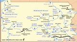
Home      Discussion      Topics      Dictionary      Almanac
Signup       Login
Pennsylvania Canal

Pennsylvania Canal

Overview
Pennsylvania Canal refers generally to a complex system of canals, dams, locks
Lock (water transport)
A lock is a device for raising and lowering boats between stretches of water of different levels on river and canal waterways. The distinguishing feature of a lock is a fixed chamber in which the water level can be varied; whereas in a caisson lock, a boat lift, or on a canal inclined plane, it is...

, tow paths, aqueduct
Aqueduct
An aqueduct is a water supply or navigable channel constructed to convey water. In modern engineering, the term is used for any system of pipes, ditches, canals, tunnels, and other structures used for this purpose....

s, and other infrastructure including, in some cases, railroads in Pennsylvania. The Pennsylvania Assembly of 1824 applied the term to the canals and railroads of the Main Line of Public Works
Main Line of Public Works
The Main Line of Public Works was a railroad and canal system built by the Commonwealth of Pennsylvania in the 19th century. It ran from Philadelphia west through Harrisburg and across the state to Pittsburgh and connected with other divisions of the Pennsylvania Canal...

 to be built across the southern part of the state, and the term was also applied to canals later added to the state system. Privately built canals, not technically part of the Pennsylvania Canal, linked to the public system and added to its value. Though most of the canals no longer have any function, some segments retain value as historic and recreational sites.
Discussion
Ask a question about 'Pennsylvania Canal'
Start a new discussion about 'Pennsylvania Canal'
Answer questions from other users
Full Discussion Forum
 
Unanswered Questions
Encyclopedia
Pennsylvania Canal refers generally to a complex system of canals, dams, locks
Lock (water transport)
A lock is a device for raising and lowering boats between stretches of water of different levels on river and canal waterways. The distinguishing feature of a lock is a fixed chamber in which the water level can be varied; whereas in a caisson lock, a boat lift, or on a canal inclined plane, it is...

, tow paths, aqueduct
Aqueduct
An aqueduct is a water supply or navigable channel constructed to convey water. In modern engineering, the term is used for any system of pipes, ditches, canals, tunnels, and other structures used for this purpose....

s, and other infrastructure including, in some cases, railroads in Pennsylvania. The Pennsylvania Assembly of 1824 applied the term to the canals and railroads of the Main Line of Public Works
Main Line of Public Works
The Main Line of Public Works was a railroad and canal system built by the Commonwealth of Pennsylvania in the 19th century. It ran from Philadelphia west through Harrisburg and across the state to Pittsburgh and connected with other divisions of the Pennsylvania Canal...

 to be built across the southern part of the state, and the term was also applied to canals later added to the state system. Privately built canals, not technically part of the Pennsylvania Canal, linked to the public system and added to its value. Though most of the canals no longer have any function, some segments retain value as historic and recreational sites.

History


The canal era began in Pennsylvania in 1797 with the Conewago Canal
Conewago Canal
The Conewago Canal, on the west bank of the Susquehanna River below York Haven, Pennsylvania, south of Harrisburg in York County, enabled late 18th and early 19th century rivercraft to safely bypass rapids at Conewago Falls. Work on the canal of less than began in 1793 and was completed in 1797...

, which carried riverboats around Conewago Falls on the Susquehanna River
Susquehanna River
The Susquehanna River is a river located in the northeastern United States. At long, it is the longest river on the American east coast that drains into the Atlantic Ocean, and with its watershed it is the 16th largest river in the United States, and the longest river in the continental United...

 near York Haven
York Haven, Pennsylvania
York Haven is a borough in York County, Pennsylvania, United States. The population was 709 at the 2010 census. The borough is the home of the Brunner Island coal-fired electrical generation plant, located on the Susquehanna River on Wago Road and operated by PPL.-Geography:York Haven is located at...

. Spurred by construction of the Erie Canal
Erie Canal
The Erie Canal is a waterway in New York that runs about from Albany, New York, on the Hudson River to Buffalo, New York, at Lake Erie, completing a navigable water route from the Atlantic Ocean to the Great Lakes. The canal contains 36 locks and encompasses a total elevation differential of...

 between 1817 and 1825 and the competitive advantage it gave New York State in moving people and materials to and from the interior of the continent, Pennsylvanians built hundreds of miles of canals during the early decades of the 19th century. These included two canals built by Pennsylvania stock companies, the Schuylkill Canal
Schuylkill Canal
Schuylkill Canal is the common, but technically inaccurate, name for the Schuylkill Navigation, a 19th-century commercial waterway in and along the Schuylkill River in the U.S. state of Pennsylvania. The "canal" was actually a system of interconnected man-made canals and slack-water pools in the...

 from Philadelphia to Port Carbon
Port Carbon, Pennsylvania
Port Carbon is a borough of Schuylkill County, Pennsylvania, two miles northeast of Pottsville, Pa. It is in a coal-mining area; in the past, ironworks had been a feature of the borough. In 1900, 2,168 people lived here; in 1910, 2,678 people were inhabitants of Port Carbon...

 and the Union Canal
Union Canal (Pennsylvania)
The Union Canal was a towpath canal that existed in southeastern Pennsylvania in the United States during the 19th century. First proposed in 1690 to connect Philadelphia with the Susquehanna River, it ran approximately 75 mi from Middletown on the Susquehanna below Harrisburg to Reading on...

 from Reading
Reading, Pennsylvania
Reading is a city in southeastern Pennsylvania, USA, and seat of Berks County. Reading is the principal city of the Greater Reading Area and had a population of 88,082 as of the 2010 census, making it the fifth most populated city in the state after Philadelphia, Pittsburgh, Allentown and Erie,...

 to Middletown
Middletown, Dauphin County, Pennsylvania
Middletown is a borough in Dauphin County, Pennsylvania, on the Susquehanna River, nine miles southeast of Harrisburg. It is part of the Harrisburg–Carlisle Metropolitan Statistical Area.-History:...

. By 1834, the Main Line of Public Works, a system of interlocking canals, railways, and inclined plane
Inclined plane
The inclined plane is one of the original six simple machines; as the name suggests, it is a flat surface whose endpoints are at different heights. By moving an object up an inclined plane rather than completely vertical, the amount of force required is reduced, at the expense of increasing the...

s, was hauling passengers and freight up to 391 miles (629 km) between Philadelphia and Pittsburgh. Though not all in concurrent operation, the total length of the canals built in Pennsylvania eventually reached 1243 miles (2,000 km).

By 1840, work had been completed not only on the Main Line of Public Works but on many other lines, officially called divisions. The Main Line consisted of the Eastern Division, the Juniata Division, the Western Division, the Philadelphia and Columbia Railroad, and the Allegheny Portage Railroad
Allegheny Portage Railroad
The Allegheny Portage Railroad was the first railroad constructed through the Allegheny Mountains in central Pennsylvania, United States. It was a series of 10 inclines, approximately long, and operated from 1834 to 1854...

. North–south divisions operated along the Delaware River
Delaware River
The Delaware River is a major river on the Atlantic coast of the United States.A Dutch expedition led by Henry Hudson in 1609 first mapped the river. The river was christened the South River in the New Netherland colony that followed, in contrast to the North River, as the Hudson River was then...

 in the east, the Susquehanna River in the middle of the state, and the Beaver River
Beaver River (Pennsylvania)
The Beaver River is a tributary of the Ohio River in Western Pennsylvania in the United States with a length of approximately 21 mi . It flows through a historically important coal-producing region north of Pittsburgh...

 in the west. A few additions were completed after 1840.

By about 1850, railroads had begun displacing canals as the preferred method of long-distance transportation. In 1852, the Pennsylvania Railroad
Pennsylvania Railroad
The Pennsylvania Railroad was an American Class I railroad, founded in 1846. Commonly referred to as the "Pennsy", the PRR was headquartered in Philadelphia, Pennsylvania....

 (PRR) began offering rail service from Philadelphia to Pittsburgh, and in 1857, it bought the Main Line Canal from the state. In 1859, all canals owned by the commonwealth were sold. The PRR formed the Pennsylvania Canal Company in 1867 and continued to use canals to haul freight. However, the canal business declined steadily in the last quarter of the century, and most Pennsylvania canals no longer functioned after 1900.

State built


The state funded the following canals in Pennsylvania. For interstate canals, the listed mileage is for the Pennsylvania portion only.

Main Line

  • Eastern Division, Columbia to Clarks Ferry, 43 miles (69 km)
  • Juniata Division, Juniata Aqueduct to Hollidaysburg, 127 miles (204 km)
  • Western Division, Johnstown to Pittsburgh, 104 miles (167 km)
  • Allegheny Outlet, Western Division to Allegheny River, 0.75 miles (1.21 km)
  • Kittanning Feeder, Kittanning to Western Division, 14 miles (23 km)

Susquehanna

  • Susquehanna Division
    Pennsylvania Canal (Susquehanna Division)
    The only canal of the Susquehanna Division of the Pennsylvania Canal ran along the west bank of the main stem of the Susquehanna River between a lock near the mouth of the Juniata River and the canal basin at Northumberland...

    , Clarks Ferry to Northumberland, 41 miles (66 km)
  • West Branch Division
    Pennsylvania Canal (West Branch Division)
    The West Branch Division of the Pennsylvania Canal ran from the canal basin at Northumberland, Pennsylvania, at the confluence of the West Branch Susquehanna River with the main stem of the Susquehanna River, north through Muncy, then west through Williamsport, Jersey Shore, and Lock Haven to its...

    , Northumberland to Farrandsville, 73 miles (117 km)
  • North Branch Division
    Pennsylvania Canal (North Branch Division)
    The North Branch Division of the Pennsylvania Canal was an historic waterway that ran along the North Branch Susquehanna River between southern New York and north-central Pennsylvania in the United States...

    , Northumberland to New York State line, 169 miles (272 km)
  • Wiconisco Canal
    Wiconisco Canal
    The Wiconisco Canal was a 19th century transportation waterway, about long, in Dauphin County in the U.S. state of Pennsylvania. Running along the east bank of the Susquehanna River between Millersburg and Duncan's Island at the mouth of the Juniata River, the canal overcame about of...

    , Clarks Ferry to Millersburg, 12 miles (19 km)
  • Lewisburg Cut, West Branch Division to Lewisburg, 0.75 miles (1.21 km)
  • Bald Eagle Cut, West Branch Division through Lock Haven to Bald Eagle Creek, 4 miles (6 km)

Beaver and Erie

  • Beaver Division
    Beaver and Erie Canal
    The Beaver and Erie Canal, also known as the Erie Extension Canal, was part of the Pennsylvania Canal system and consisted of three sections: the Beaver Division, the Shenango Division, and the Conneaut Division...

    , Ohio River at Beaver to Pulaski, 31 miles (50 km)
  • Shenango Division
    Beaver and Erie Canal
    The Beaver and Erie Canal, also known as the Erie Extension Canal, was part of the Pennsylvania Canal system and consisted of three sections: the Beaver Division, the Shenango Division, and the Conneaut Division...

    , Pulaski to Conneaut Lake, 61 miles (98 km)
  • Conneaut Division
    Beaver and Erie Canal
    The Beaver and Erie Canal, also known as the Erie Extension Canal, was part of the Pennsylvania Canal system and consisted of three sections: the Beaver Division, the Shenango Division, and the Conneaut Division...

    , Conneaut to Erie, 46 miles (74 km)
  • French Creek Feeder, Meadville to Conneaut Lake, 25 miles (40 km)
  • Franklin Line, French Creek Feeder to Franklin, 22 miles (35 km)

Delaware

  • Delaware Division
    Pennsylvania Canal (Delaware Division)
    The Delaware Division of the Pennsylvania Canal, more commonly called the Delaware Canal, runs from the Lehigh River at Easton south to Bristol...

    , Easton to Bristol, 60 miles (97 km)

Privately built


Private entities funded the following canals in Pennsylvania. For interstate canals, the listed mileage is for the Pennsylvania portion only.
  • Bald Eagle and Spring Creek Navigation
    Bald Eagle and Spring Creek Navigation
    The Bald Eagle and Spring Creek Navigation Company was a canal company in central Pennsylvania intended to link the iron industry of Bellefonte, Pennsylvania, with the Pennsylvania canal system. Opened for half its length in 1837, the remainder of the canal was not completed until 1848...

     Canal, Bellefonte to Bald Eagle Cut, 22 miles (35 km)
  • Codorus Navigation
    Codorus Navigation
    The Codorus Navigation Company, based in York in south-central Pennsylvania, was formed in 1829 to make a navigable waterway along Codorus Creek from York to the Susquehanna River, a distance of...

    , York to Susquehanna River, 11 miles (18 km)
  • Conestoga Navigation, Lancaster to Susquehanna River, 18 miles (29 km)
  • Conewago Canal
    Conewago Canal
    The Conewago Canal, on the west bank of the Susquehanna River below York Haven, Pennsylvania, south of Harrisburg in York County, enabled late 18th and early 19th century rivercraft to safely bypass rapids at Conewago Falls. Work on the canal of less than began in 1793 and was completed in 1797...

    , around Conewago Falls on Susquehanna, 1.25 miles (2.01 km)
  • Delaware and Hudson Canal
    Delaware and Hudson Canal
    The Delaware and Hudson Canal was the first venture of the Delaware and Hudson Canal Company, which later developed the Delaware and Hudson Railway...

    , Honesdale to Roundout, New York, 25 miles (40 km)
  • Lehigh Canal
    Lehigh Canal
    The Lehigh Canal was constructed by the Lehigh Coal & Navigation Company to carry anthracite from the upper Lehigh Valley to the urban markets of the northeast, especially Philadelphia...

    , White Haven to Easton, 72 miles (116 km)
  • Junction Canal
    Junction Canal
    The Junction Canal was a canal in the states of New York and Pennsylvania in the United States. The canal was also called the Arnot Canal, after the name of its principal stockholder, John Arnot of Elmira, New York. The canal was built and operated by a private stock company. The canal was partly...

    , Athens to Elmira, New York, 3.25 miles (5.23 km)
  • Leiper Canal
    Leiper Canal
    Early in the 19th century, the Leiper Canal ran about along Crum Creek in Delaware County, Pennsylvania. George Leiper, who financed the canal, used it between 1829 and 1852 to haul stone in flat-bottomed boats from his quarry near Springfield to the navigable Delaware River at Eddystone. The...

    , Crum Creek near Chester, several miles
  • Muncy Cut, Muncy to West Branch Susquehanna, 0.75 miles (1.21 km)
  • Pennsylvania and Ohio Canal
    Pennsylvania and Ohio Canal
    The Pennsylvania and Ohio Canal, also known as the P & O Canal, the Cross Cut Canal and the Mahoning Canal was a shipping canal which operated from 1840 until 1877...

    , New Castle to Akron, Ohio, 18 miles (29 km)
  • Pine Grove Feeder, Union Canal to Pine Grove, 22 miles (35 km)
  • Sandy and Beaver Canal
    Sandy and Beaver Canal
    The Sandy and Beaver Canal ran from the Ohio and Erie Canal at Bolivar, Ohio, to the Ohio River at Glasgow, Pennsylvania. It had 90 locks, was chartered in 1828 and completed in 1848. However, the middle section of the canal had many problems from the beginning and fell into disrepair...

    , Glasgow to Bolivar, Ohio, 0.75 miles (1.21 km)
  • Schuylkill Canal
    Schuylkill Canal
    Schuylkill Canal is the common, but technically inaccurate, name for the Schuylkill Navigation, a 19th-century commercial waterway in and along the Schuylkill River in the U.S. state of Pennsylvania. The "canal" was actually a system of interconnected man-made canals and slack-water pools in the...

    , Port Carbon to Philadelphia, 108 miles (174 km)
  • Susquehanna and Tidewater Canal
    Susquehanna and Tidewater Canal
    The Susquehanna and Tidewater Canal between Wrightsville, Pennsylvania, and Havre de Grace, Maryland, at the head of Chesapeake Bay, provided an interstate shipping alternative to 19th-century arks, rafts, and boats plying the difficult waters of the lower Susquehanna River...

    , Columbia to Havre de Grace, Maryland, 30 miles (48 km)
  • Union Canal
    Union Canal (Pennsylvania)
    The Union Canal was a towpath canal that existed in southeastern Pennsylvania in the United States during the 19th century. First proposed in 1690 to connect Philadelphia with the Susquehanna River, it ran approximately 75 mi from Middletown on the Susquehanna below Harrisburg to Reading on...

    , Reading to Middletown, 78 miles (126 km)

Parks, monuments, historic places


Several canal segments or other canal infrastructure in Pennsylvania are listed on the National Register of Historic Places
National Register of Historic Places
The National Register of Historic Places is the United States government's official list of districts, sites, buildings, structures, and objects deemed worthy of preservation...

. One complete canal, the Delaware Canal
Pennsylvania Canal (Delaware Division)
The Delaware Division of the Pennsylvania Canal, more commonly called the Delaware Canal, runs from the Lehigh River at Easton south to Bristol...

, is the main feature of Delaware Canal State Park
Delaware Canal State Park
Delaware Canal State Park is a Pennsylvania state park in Bucks and Northampton Counties in Pennsylvania in the United States. The main attraction of the park is the Delaware Canal, which at is the only canal that remains fully intact from the towpath canal-building days of the 19th century...

 (formerly Theodore Roosevelt State Park) between Bristol and Easton. It is continuously intact for its full length of 60 miles (97 km).

Other Pennsylvania canal infrastructure on the National Register includes the following:
  • Allegheny Portage Railroad
    Allegheny Portage Railroad
    The Allegheny Portage Railroad was the first railroad constructed through the Allegheny Mountains in central Pennsylvania, United States. It was a series of 10 inclines, approximately long, and operated from 1834 to 1854...

    , from Johnstown to Hollidaysburg, which is both a National Historic Site
    National Historic Sites (United States)
    National Historic Sites are protected areas of national historic significance in the United States. A National Historic Site usually contains a single historical feature directly associated with its subject...

     and a National Historic Landmark
    National Historic Landmark
    A National Historic Landmark is a building, site, structure, object, or district, that is officially recognized by the United States government for its historical significance...

  • D & H Canal Company office, scenic drive, northwest side of Lackawaxen Township
    Lackawaxen Township, Pennsylvania
    Lackawaxen Township is the largest and northernmost township in Pike County, Pennsylvania. The population was 4,994 at the 2010 census. The Delaware River, which marks the eastern boundary of the township, joins the Lackawaxen River at Lackawaxen Village...

  • Juniata Division, guard lock and feeder dam, Raystown Branch
    Pennsylvania Canal Guard Lock and Feeder Dam, Raystown Branch
    Pennsylvania Canal Guard Lock and Feeder Dam, Raystown Branch, also known as the Raystown Branch Feeder Canal, is a historic canal structure located at Henderson Township in Huntingdon County, Pennsylvania. The property includes the remains of a guard lock and feeder dam...

    , Juniata River
    Juniata River
    The Juniata River is a tributary of the Susquehanna River, approximately long, in central Pennsylvania in the United States. The river is considered scenic along much of its route, having a broad and shallow course passing through several mountain ridges and steeply-lined water gaps...

    , 2.5 miles (4 km) east of Huntingdon
    Huntingdon, Pennsylvania
    Huntingdon is a borough in Huntingdon County, Pennsylvania. It is the county seat of Huntingdon County. It is located along the Juniata River, west of Harrisburg, about halfway between Pittsburgh and Harrisburg, in an agricultural and fruit-growing region, with valuable forests and deposits of...

    , south of U.S. Route 22, near Springfield, Pennsylvania
  • Juniata Division, 1.5 miles (2.4 km) of canal between the Pennsylvania Railroad main line and the Juniata River in Granville Township
    Granville Township, Mifflin County, Pennsylvania
    Granville Township is a township in Mifflin County, Pennsylvania, United States. The population was 4,895 at the 2000 census.-Geography:According to the United States Census Bureau, the township has a total area of , of which, of it is land and of it is water.-Demographics:As of the census of...

  • Leesport Lock House
    Leesport Lock House
    The Leesport Lock House is a house accompanying a lock on the Schuylkill Canal in Leesport, Pennsylvania, USA. The house was built adjacent to the Leesport Lock to allow canal barges to move quickly up and down the canal...

    , a Lockhouse on the Schuylkill Canal in Leesport
    Leesport, Pennsylvania
    Leesport is a borough in Berks County, Pennsylvania, United States. The population was 1,805 at the 2000 census.-Geography:Leesport is located at ....

  • Lehigh Canal, Allentown to Hopeville section, Lehigh River near Bethlehem
    Bethlehem, Pennsylvania
    Bethlehem is a city in Lehigh and Northampton Counties in the Lehigh Valley region of eastern Pennsylvania, in the United States. As of the 2010 census, the city had a total population of 74,982, making it the seventh largest city in Pennsylvania, after Philadelphia, Pittsburgh, Allentown, Erie,...

  • Lehigh Canal, Carbon County section along Lehigh River, Weissport
    Weissport, Pennsylvania
    Weissport is a borough in Carbon County, Pennsylvania, United States. The town was founded in 1792 by Col. Jacob Weiss. This particular area was located between Lehighton, Parryville and Longrun. Soon after the town itself was established, and the first wooden bridge over the river to the town...

     and vicinity
  • Lehigh Canal, Glendon and Abbott Street Industrial Sites, Lehigh River from Hopeville to confluence of Lehigh and Delaware Rivers near Easton
    Easton, Pennsylvania
    Easton is a city in Northampton County, Pennsylvania, United States. The population was 26,800 as of the 2010 census. It is the county seat of Northampton County....

  • Lehigh Canal, Lehigh Gap to South Walnutport
    Walnutport, Pennsylvania
    Walnutport is a borough in Northampton County, Pennsylvania, United States. Incorporated in 1909, Walnutport is located in the Lehigh Valley region of Pennsylvania along the Lehigh River.The population of Walnutport was 2,043 at the 2000 census. The U.S...

     boundary
  • Lehigh Canal, Walnutport to Allentown section, Allentown
    Allentown, Pennsylvania
    Allentown is a city located in Lehigh County, Pennsylvania, in the United States. It is Pennsylvania's third most populous city, after Philadelphia and Pittsburgh, and the 215th largest city in the United States. As of the 2010 census, the city had a total population of 118,032 and is currently...

     and vicinity
  • Schuylkill Navigation Canal, Oakes Reach section, north and east bank of Schuylkill River
    Schuylkill River
    The Schuylkill River is a river in Pennsylvania. It is a designated Pennsylvania Scenic River.The river is about long. Its watershed of about lies entirely within the state of Pennsylvania. The source of its eastern branch is in the Appalachian Mountains at Tuscarora Springs, near Tamaqua in...

     from Pennsylvania Route 113 to Lock 61
  • Union Canal Tunnel, west of Lebanon
    Lebanon, Pennsylvania
    Lebanon, formerly known as Steitztown, is a city in and the county seat of Lebanon County, Pennsylvania, United States. The population was 25,477 at the 2010 census, a 4.2% increase from the 2000 count of 24,461...

     off Pennsylvania Route 72
  • West Branch Division, canal and Limestone Run aqueduct, Milton
    Milton, Pennsylvania
    Milton is a borough in Northumberland County, Pennsylvania, on the Susquehanna River, north of Harrisburg. Settled in 1770, it was incorporated in 1817, and is governed by a charter that was revised in 1890...

  • Western Division, canal north of Torrance in Westmoreland County
    Westmoreland County, Pennsylvania
    -Demographics:As of the census of 2000, there were 369,993 people, 149,813 households, and 104,569 families residing in the county. The population density was 361 people per square mile . There were 161,058 housing units at an average density of 157 per square mile...

  • Western Division, canal along the Conemaugh River
    Conemaugh River
    The Conemaugh River is a long tributary of the Kiskiminetas River in Westmoreland, Indiana, and Cambria counties in the U.S. state of Pennsylvania.- Course :...

    near Robinson

External links