

San Rafael River (Utah)
Encyclopedia
The San Rafael River is a tributary of the Green River
, approximately 90 miles (144.8 km) long, in east central Utah
in the United States
. The river flows across a sparsely populated arid region of the Colorado Plateau
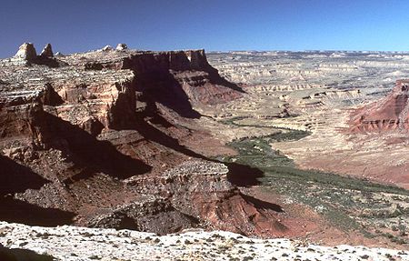
, and is known for the isolated, scenic gorge through which it flows.
 It rises in northwestern Emery County
, approximately 5 miles (8 km) southeast of Castle Dale
, by the confluence of Cottonwood, Huntington, and Ferron creeks, which provide its headwaters in the Wasatch Plateau region. It flows ESE along the north side of the Coal Cliffs and the prominent anticline
called the San Rafael Swell
, passing north of Window Butte (Window Blind Peak) and through two narrow slot canyon
s in Coconino Sandstone
called the Upper and Lower Black Box. This area is known as the San Rafael Gorge, sometimes called the "Little Grand Canyon". (Actually, the "Little Grand Canyon" is a few miles upstream where the San Rafael passes between the Wedge on the north and Sid's Mountain and No Man's Mountain on the south). After passing through the San Rafael Reef
it enters the 15 mile (24 km) long San Rafael Valley, where it joins the Green River
from the west, approximately 10 miles (16.1 km) south of the town of Green River
. The San Rafael is the last major tributary of the Green before it joins the Colorado River in Canyonlands National Park
.
Diversion tunnels at the headwaters of the river in the Manti-La Sal National Forest
provide irrigation
water to Sanpete County
on the west side of the Wasatch Plateau.
Green River (Utah)
The Green River, located in the western United States, is the chief tributary of the Colorado River. The watershed of the river, known as the Green River Basin, covers parts of Wyoming, Utah, and Colorado. The Green River is long, beginning in the Wind River Mountains of Wyoming and flowing...
, approximately 90 miles (144.8 km) long, in east central Utah
Utah
Utah is a state in the Western United States. It was the 45th state to join the Union, on January 4, 1896. Approximately 80% of Utah's 2,763,885 people live along the Wasatch Front, centering on Salt Lake City. This leaves vast expanses of the state nearly uninhabited, making the population the...
in the United States
United States
The United States of America is a federal constitutional republic comprising fifty states and a federal district...
. The river flows across a sparsely populated arid region of the Colorado Plateau
Colorado Plateau
The Colorado Plateau, also called the Colorado Plateau Province, is a physiographic region of the Intermontane Plateaus, roughly centered on the Four Corners region of the southwestern United States. The province covers an area of 337,000 km2 within western Colorado, northwestern New Mexico,...
, and is known for the isolated, scenic gorge through which it flows.
Emery County, Utah
Emery County is a county located in the U.S. state of Utah. As of 2000 the population was 10,860, and by 2009 had been estimated to decrease to 10,629. It was named for George W. Emery, governor of the Utah Territory in 1875...
, approximately 5 miles (8 km) southeast of Castle Dale
Castle Dale, Utah
Castle Dale is a city in Emery County, Utah, United States. The population was 1,657 at the 2000 census. It is the county seat of Emery County.-History:...
, by the confluence of Cottonwood, Huntington, and Ferron creeks, which provide its headwaters in the Wasatch Plateau region. It flows ESE along the north side of the Coal Cliffs and the prominent anticline
Anticline
In structural geology, an anticline is a fold that is convex up and has its oldest beds at its core. The term is not to be confused with antiform, which is a purely descriptive term for any fold that is convex up. Therefore if age relationships In structural geology, an anticline is a fold that is...
called the San Rafael Swell
San Rafael Swell
The San Rafael Swell is a large geologic feature located in south-central Utah, USA about 30 miles west of Green River, Utah. The San Rafael Swell, approximately by , consists of a giant dome-shaped anticline of sandstone, shale, and limestone that was pushed up during the Paleocene Laramide...
, passing north of Window Butte (Window Blind Peak) and through two narrow slot canyon
Slot canyon
A slot canyon is a narrow canyon, formed by the wear of water rushing through rock. A slot canyon is significantly deeper than it is wide. Some slot canyons can measure less than one metre across at the top but drop more than 30 m to the floor of the canyon.Most slot canyons are formed in...
s in Coconino Sandstone
Coconino Sandstone
Coconino Sandstone is a geologic formation named after its exposure in Coconino County, Arizona. This formation spreads across the Colorado Plateau province of the United States, including northern Arizona, northwest Colorado, Nevada, and Utah....
called the Upper and Lower Black Box. This area is known as the San Rafael Gorge, sometimes called the "Little Grand Canyon". (Actually, the "Little Grand Canyon" is a few miles upstream where the San Rafael passes between the Wedge on the north and Sid's Mountain and No Man's Mountain on the south). After passing through the San Rafael Reef
San Rafael Reef
The San Rafael Reef is a geologic feature located in Emery County in central Utah, part of the Colorado Plateau. Approximately 75 miles long, it is the name given to the distinctive eastern edge of the San Rafael Swell...
it enters the 15 mile (24 km) long San Rafael Valley, where it joins the Green River
Green River (Utah)
The Green River, located in the western United States, is the chief tributary of the Colorado River. The watershed of the river, known as the Green River Basin, covers parts of Wyoming, Utah, and Colorado. The Green River is long, beginning in the Wind River Mountains of Wyoming and flowing...
from the west, approximately 10 miles (16.1 km) south of the town of Green River
Green River, Utah
Green River is a city in Emery County, Utah, United States. The population was 973 at the 2000 census.-Geography:Green River is located at , on the banks of the Green River, after which the city is named. The San Rafael Swell region is to the west of Green River, while Canyonlands National Park...
. The San Rafael is the last major tributary of the Green before it joins the Colorado River in Canyonlands National Park
Canyonlands National Park
Canyonlands National Park is a U.S. National Park located in southeastern Utah near the town of Moab and preserves a colorful landscape eroded into countless canyons, mesas and buttes by the Colorado River, the Green River, and their respective tributaries. The park is divided into four districts:...
.
Diversion tunnels at the headwaters of the river in the Manti-La Sal National Forest
Manti-La Sal National Forest
The Manti-La Sal National Forest covers 1,270,646 acres and is located in the central and southeastern parts of the U.S. state of Utah and the extreme western part of Colorado...
provide irrigation
Irrigation
Irrigation may be defined as the science of artificial application of water to the land or soil. It is used to assist in the growing of agricultural crops, maintenance of landscapes, and revegetation of disturbed soils in dry areas and during periods of inadequate rainfall...
water to Sanpete County
Sanpete County, Utah
Sanpete County is a county located in the U.S. state of Utah. The population according to the 2010 U.S. Census was 27,822. It was possibly named for a Ute Indian chief named Sanpitch, which was corrupted to Sanpete. Its county seat is Manti and its largest city is Ephraim.-Geography:According to...
on the west side of the Wasatch Plateau.