
Salt Springs State Park
Encyclopedia
Salt Springs State Park is a Pennsylvania state park in Franklin Township
, Susquehanna County
, Pennsylvania
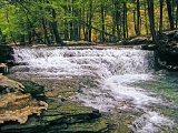
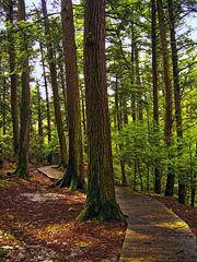
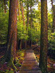
, in the United States. The park is home to some massive hemlock
trees that are over 500 years old and are some of the largest trees in all of Pennsylvania. The park also features a gorge with three waterfalls on Fall Brook. Salt Springs State Park is 7 miles (11.3 km) north of Montrose
, just off Pennsylvania Route 29
. The park is the only state park in Pennsylvania that is managed by a non-profit organization, the Friends of Salt Springs Park. The state owns 405 acres (163.9 ha) of land and the Friends own an additional 437 acres (176.8 ha) bringing the total amount of protected land to 842 acres (340.7 ha).
s came to the Salt Springs area in the 1790s, and found an area of unbroken forest that was dominated by the eastern hemlock
tree. The settlers focused on clearing the land for farming. Many of the trees were simply burned, while others were used to build log cabin
s. Eventually the settlers began stripping the hemlocks of their bark for use in tanneries
, while other trees were harvested for the lumber industry. Sawmill
s soon appeared on Silver Creek and other streams in the area. However, not all the old hemlocks were harvested. Those still standing in and about Fall Brook Gorge
were left because the area had become a recreation destination as soon as the early 19th century.
of the area used the springs as a salt
supply for many years. The settlers also extracted salt from the waters of Salt Spring. Numerous entrepreneurs attempted to extract salt from the springs for a profit, but most failed because it simply was not possible to extract enough salt.
prospectors were the next group to try to make a living from the Salt Springs area. Pennsylvania was in the midst of an oil boom in the late 19th century after oil had been discovered near Titusville
, 280 miles (450.6 km) to the west. The North Penn Oil and Gas Company sunk a test well in 1902. They quickly failed, plugged the well and left the area. Methane gas escaped from the well and was used by the Wheaton family, owners of a nearby dairy farm. They used this gas, released by the oil prospectors, for many years to provide lighting for their home and gas for their stove.
, "Friends of Salt Springs Park", was established in 1994 to help protect and preserve the park. Pennsylvania had acquired the land in 1973, but had been financially unable to preserve the historic buildings or develop the parks lands. When the historic buildings on the former Wheaton Farm were slated to be demolished, a group of concerned citizens teamed together to preserve the farm buildings and develop the park. They signed a 10 year contract with Susquehanna County
to become the caretakers of the park in 1995. The contract was renewed in 2005.
 The Wheaton family owned the lands of Salt Springs State Park from 1840 until 1973, when they sold their land to the Commonwealth of Pennsylvania. The family established a dairy farm on the land and invited tourists to enjoy the towering hemlocks and Fall Brook Gorge.
The buildings of the Wheaton farm are used today by the park for numerous purposes. Wheaton House, a timber framed
post and beam structure crafted from eastern hemlock, holds the offices of "The Friends of Salt Springs Park". A second farm house provides rental income to help support the Friends' work. A carriage barn next to the Wheaton House is built entirely of hemlock timbers with hand hewn beams and sawed posts. It also has a foundation of native stone, built without mortar
. The dairy barn provides space for programs in classrooms and meeting areas.
, except for the 30 acres (12.1 ha) designated as a nature preserve in the Fall Brook Gorge area. Hunters are expected to follow the rules and regulations of the Pennsylvania Game Commission
. The common game species are Ruffed Grouse
, squirrel
s, turkey
, and white-tailed deer
. The hunting of groundhog
s is prohibited. Fall Brook and Silver Creek are designated trout
fisheries by the Pennsylvania Fish and Boat Commission
, which stocks
the streams with trout prior to the spring trout season.
Salt Springs State Park has 8 sites for rustic tent camping and 3 cottages that are available for rent on a weekly or nightly basis.
There is a small picnic
area between Silver Creek and Fall Brook with tables and grills. There also is a large timber frame pavilion
near Salt Spring. This pavilion is a former barn.
and cross-country skiing
. These trails pass through old-growth forest, overlook the gorge, and wind their way through fields and woods.
Franklin Township, Susquehanna County, Pennsylvania
Franklin Township is a township in Susquehanna County, Pennsylvania, United States. The population was 938 at the 2000 census. Salt Springs State Park, a Pennsylvania state park, is in Franklin Township.-Geography:...
, Susquehanna County
Susquehanna County, Pennsylvania
-Demographics:As of the census of 2000, there were 42,238 people, 16,529 households, and 11,785 families residing in the county. The population density was 51 people per square mile . There were 21,829 housing units at an average density of 26 per square mile...
, Pennsylvania
Pennsylvania
The Commonwealth of Pennsylvania is a U.S. state that is located in the Northeastern and Mid-Atlantic regions of the United States. The state borders Delaware and Maryland to the south, West Virginia to the southwest, Ohio to the west, New York and Ontario, Canada, to the north, and New Jersey to...
, in the United States. The park is home to some massive hemlock
Tsuga
Tsuga is a genus of conifers in the family Pinaceae. The common name hemlock is derived from a perceived similarity in the smell of its crushed foliage to that of the unrelated plant poison hemlock....
trees that are over 500 years old and are some of the largest trees in all of Pennsylvania. The park also features a gorge with three waterfalls on Fall Brook. Salt Springs State Park is 7 miles (11.3 km) north of Montrose
Montrose, Pennsylvania
Montrose is a borough in Susquehanna County, Pennsylvania, United States, north by west of Scranton, Pennsylvania. Montrose was laid out in 1812 and incorporated as a borough on March 19, 1824. Its name is a combination of "mont", the French word for “mountain” and Rose, for Dr. L R. Rose, a...
, just off Pennsylvania Route 29
Pennsylvania Route 29
Pennsylvania Route 29 is a 118 mile long north–south state highway that runs through most of eastern Pennsylvania. The route currently exists in two segments, a southern segment and a northern segment. The southernmost terminus of the designation is at U.S. Route 30 in Malvern...
. The park is the only state park in Pennsylvania that is managed by a non-profit organization, the Friends of Salt Springs Park. The state owns 405 acres (163.9 ha) of land and the Friends own an additional 437 acres (176.8 ha) bringing the total amount of protected land to 842 acres (340.7 ha).
Hemlocks
The first settlerSettler
A settler is a person who has migrated to an area and established permanent residence there, often to colonize the area. Settlers are generally people who take up residence on land and cultivate it, as opposed to nomads...
s came to the Salt Springs area in the 1790s, and found an area of unbroken forest that was dominated by the eastern hemlock
Eastern Hemlock
Tsuga canadensis, also known as eastern or Canadian hemlock, and in the French-speaking regions of Canada as pruche du Canada, is a coniferous tree native to eastern North America. It ranges from northeastern Minnesota eastward through southern Quebec to Nova Scotia, and south in the Appalachian...
tree. The settlers focused on clearing the land for farming. Many of the trees were simply burned, while others were used to build log cabin
Log cabin
A log cabin is a house built from logs. It is a fairly simple type of log house. A distinction should be drawn between the traditional meanings of "log cabin" and "log house." Historically most "Log cabins" were a simple one- or 1½-story structures, somewhat impermanent, and less finished or less...
s. Eventually the settlers began stripping the hemlocks of their bark for use in tanneries
Tanning
Tanning is the making of leather from the skins of animals which does not easily decompose. Traditionally, tanning used tannin, an acidic chemical compound from which the tanning process draws its name . Coloring may occur during tanning...
, while other trees were harvested for the lumber industry. Sawmill
Sawmill
A sawmill is a facility where logs are cut into boards.-Sawmill process:A sawmill's basic operation is much like those of hundreds of years ago; a log enters on one end and dimensional lumber exits on the other end....
s soon appeared on Silver Creek and other streams in the area. However, not all the old hemlocks were harvested. Those still standing in and about Fall Brook Gorge
Fall Brook Gorge
Fall Brook Gorge located in the Town of Geneseo, in Livingston County, New York, outside the Village of Geneseo, New York is an excellent example of Upper and Middle Devonian rock formations....
were left because the area had become a recreation destination as soon as the early 19th century.
Salty Springs
Salt Springs State Park is named for the salt springs found on the south side of Fall Brook. The Native AmericansNative Americans in the United States
Native Americans in the United States are the indigenous peoples in North America within the boundaries of the present-day continental United States, parts of Alaska, and the island state of Hawaii. They are composed of numerous, distinct tribes, states, and ethnic groups, many of which survive as...
of the area used the springs as a salt
Salt
In chemistry, salts are ionic compounds that result from the neutralization reaction of an acid and a base. They are composed of cations and anions so that the product is electrically neutral...
supply for many years. The settlers also extracted salt from the waters of Salt Spring. Numerous entrepreneurs attempted to extract salt from the springs for a profit, but most failed because it simply was not possible to extract enough salt.
Oil Prospecting
OilOil
An oil is any substance that is liquid at ambient temperatures and does not mix with water but may mix with other oils and organic solvents. This general definition includes vegetable oils, volatile essential oils, petrochemical oils, and synthetic oils....
prospectors were the next group to try to make a living from the Salt Springs area. Pennsylvania was in the midst of an oil boom in the late 19th century after oil had been discovered near Titusville
Titusville, Pennsylvania
Titusville is a city in Crawford County, Pennsylvania, United States. The population was 6,146 at the 2000 census. In 1859, oil was successfully drilled in Titusville, resulting in the birth of the modern oil industry.-History:...
, 280 miles (450.6 km) to the west. The North Penn Oil and Gas Company sunk a test well in 1902. They quickly failed, plugged the well and left the area. Methane gas escaped from the well and was used by the Wheaton family, owners of a nearby dairy farm. They used this gas, released by the oil prospectors, for many years to provide lighting for their home and gas for their stove.
From farm to state park
The non-profit organizationNon-profit organization
Nonprofit organization is neither a legal nor technical definition but generally refers to an organization that uses surplus revenues to achieve its goals, rather than distributing them as profit or dividends...
, "Friends of Salt Springs Park", was established in 1994 to help protect and preserve the park. Pennsylvania had acquired the land in 1973, but had been financially unable to preserve the historic buildings or develop the parks lands. When the historic buildings on the former Wheaton Farm were slated to be demolished, a group of concerned citizens teamed together to preserve the farm buildings and develop the park. They signed a 10 year contract with Susquehanna County
Susquehanna County, Pennsylvania
-Demographics:As of the census of 2000, there were 42,238 people, 16,529 households, and 11,785 families residing in the county. The population density was 51 people per square mile . There were 21,829 housing units at an average density of 26 per square mile...
to become the caretakers of the park in 1995. The contract was renewed in 2005.
The buildings of the Wheaton farm are used today by the park for numerous purposes. Wheaton House, a timber framed
Timber framing
Timber framing , or half-timbering, also called in North America "post-and-beam" construction, is the method of creating structures using heavy squared off and carefully fitted and joined timbers with joints secured by large wooden pegs . It is commonplace in large barns...
post and beam structure crafted from eastern hemlock, holds the offices of "The Friends of Salt Springs Park". A second farm house provides rental income to help support the Friends' work. A carriage barn next to the Wheaton House is built entirely of hemlock timbers with hand hewn beams and sawed posts. It also has a foundation of native stone, built without mortar
Mortar (masonry)
Mortar is a workable paste used to bind construction blocks together and fill the gaps between them. The blocks may be stone, brick, cinder blocks, etc. Mortar becomes hard when it sets, resulting in a rigid aggregate structure. Modern mortars are typically made from a mixture of sand, a binder...
. The dairy barn provides space for programs in classrooms and meeting areas.
Recreation
All of the park is open to huntingHunting
Hunting is the practice of pursuing any living thing, usually wildlife, for food, recreation, or trade. In present-day use, the term refers to lawful hunting, as distinguished from poaching, which is the killing, trapping or capture of the hunted species contrary to applicable law...
, except for the 30 acres (12.1 ha) designated as a nature preserve in the Fall Brook Gorge area. Hunters are expected to follow the rules and regulations of the Pennsylvania Game Commission
Pennsylvania Game Commission
The Pennsylvania Game Commission is the state agency responsible for wildlife conservation and management in Pennsylvania in the United States...
. The common game species are Ruffed Grouse
Ruffed Grouse
The Ruffed Grouse is a medium-sized grouse occurring in forests from the Appalachian Mountains across Canada to Alaska. It is non-migratory.The Ruffed Grouse is frequently referred to as a "partridge"...
, squirrel
Eastern Gray Squirrel
The eastern gray squirrel is a tree squirrel in the genus Sciurus native to the eastern and midwestern United States, and to the southerly portions of the eastern provinces of Canada...
s, turkey
Wild Turkey
The Wild Turkey is native to North America and is the heaviest member of the Galliformes. It is the same species as the domestic turkey, which derives from the South Mexican subspecies of wild turkey .Adult wild turkeys have long reddish-yellow to grayish-green...
, and white-tailed deer
White-tailed Deer
The white-tailed deer , also known as the Virginia deer or simply as the whitetail, is a medium-sized deer native to the United States , Canada, Mexico, Central America, and South America as far south as Peru...
. The hunting of groundhog
Groundhog
The groundhog , also known as a woodchuck, whistle-pig, or in some areas as a land-beaver, is a rodent of the family Sciuridae, belonging to the group of large ground squirrels known as marmots. Other marmots, such as the yellow-bellied and hoary marmots, live in rocky and mountainous areas, but...
s is prohibited. Fall Brook and Silver Creek are designated trout
Trout
Trout is the name for a number of species of freshwater and saltwater fish belonging to the Salmoninae subfamily of the family Salmonidae. Salmon belong to the same family as trout. Most salmon species spend almost all their lives in salt water...
fisheries by the Pennsylvania Fish and Boat Commission
Pennsylvania Fish and Boat Commission
The Pennsylvania Fish and Boat Commission is the state agency responsible for the regulation of all fishing and boating in the Commonwealth of Pennsylvania...
, which stocks
Fish stocking
Fish stocking is the practice of raising fish in a hatchery and releasing them into a river, lake, or the ocean to supplement existing populations, or to create a population where none exists...
the streams with trout prior to the spring trout season.
Salt Springs State Park has 8 sites for rustic tent camping and 3 cottages that are available for rent on a weekly or nightly basis.
There is a small picnic
Picnic
In contemporary usage, a picnic can be defined simply as a pleasure excursion at which a meal is eaten outdoors , ideally taking place in a beautiful landscape such as a park, beside a lake or with an interesting view and possibly at a public event such as before an open air theatre performance,...
area between Silver Creek and Fall Brook with tables and grills. There also is a large timber frame pavilion
Pavilion (structure)
In architecture a pavilion has two main meanings.-Free-standing structure:Pavilion may refer to a free-standing structure sited a short distance from a main residence, whose architecture makes it an object of pleasure. Large or small, there is usually a connection with relaxation and pleasure in...
near Salt Spring. This pavilion is a former barn.
Trails
Salt Springs State Park has 8.5 miles (13.7 km) of trails that are open to hikingHiking
Hiking is an outdoor activity which consists of walking in natural environments, often in mountainous or other scenic terrain. People often hike on hiking trails. It is such a popular activity that there are numerous hiking organizations worldwide. The health benefits of different types of hiking...
and cross-country skiing
Cross-country skiing
Cross-country skiing is a winter sport in which participants propel themselves across snow-covered terrain using skis and poles...
. These trails pass through old-growth forest, overlook the gorge, and wind their way through fields and woods.
- Fall Brook Trail - is a 1 miles (1.6 km) difficult trail that is marked with red blazes. The trail begins across the creek from Wheaton House and follows Fall Brook up a steep hill and passes three waterfalls. Fall Brook Trail ends at Bunny Trail.
- Silver Creek Trail is a 1.5 miles (2.4 km) easy trail that is marked with red blazes. It begins behind a dairy barn and follows Silver Creek through a forest of hemlocks with a fern understoryUnderstoryUnderstory is the term for the area of a forest which grows at the lowest height level below the forest canopy. Plants in the understory consist of a mixture of seedlings and saplings of canopy trees together with understory shrubs and herbs...
. The trail ends with a steep climb through a hardwood forest near Meadow Trail. - Meadow Trail is a 0.8 miles (1.3 km) easy trail that is marked with yellow blazes. It is reached from the Silver Creek Trail or Buckley Road. Meadow Trail is a loop that passes through meadows and by relict stone foundations.
- Hemlock Trail is a 0.4 mile (0.643736 km) moderate trail that is not marked. The trail passes through an old-growth forest of Eastern Hemlock and reaches Salt Springs gorge. A gorge observation platform is accessed from Hemlock Trail.
- Woodland Trail is a 0.25 mile (0.402335 km) easy trail that is marked with blue blazes. It loops off Hemlock Trail through the old growth forest. Hikers will need to climb over or go around a 300 year old hemlock that has fallen across the trail.
- Hardwood Trail is a 0.5 mile (0.80467 km) moderate trail that is marked with yellow blazes. The trail begins at the picnic area and ends at Woodland Trail. It passes through a stand of mixed hardwoods.
- Upland Trail is a 0.5 mile (0.80467 km) moderate trail that is marked with red blazes. It loops off Hardwood Trail and climbs a hillside that his covered with mixed hardwoods.
- Bunny Trail is a 1.5 miles (2.4 km) moderate trail that is marked with orange blazes. It is a loop that begins and ends at a parking lot that is off Buckley Road. The trail passes through a mixed forest and by several springs.
- Cliff Trail is a 1.5 miles (2.4 km) moderate trail that is marked with blue blazes. It closely follows Bunny Trail in some places. Cliff Trail passes by ferns, a pond and large boulders.
- Connector Trail is a 1.7 miles (2.7 km) easy trail that is marked with white blazes. It connects Wetland Trail and Fall Brook Trail. The trail goes through a ravine and crosses the Wetland Trail bridge.
- Wetland Trail is a 0.6 mile (0.965604 km) easy trail that is marked with blue blazes. It runs along the south bank of Fall Brook and passes through a wetland.
- Summit Trail is a 1 miles (1.6 km) moderate trail that is marked with red blazes. It climbs a gentle rise on the Friends of Salt Springs State Park property. The summit is relatively flat and is covered with a mix of widely spaced trees.
- Overlook Trail is the shortest trail in Salt Springs State Park at just 0.2 mile (0.321868 km). It was designed with handicapped accessibily in mind. It connects the falls overlook with a parking lot and Fall Brook Trail.
Nearby state parks
The following state parks are within 30 miles (48.3 km) of Salt Springs State Park:- Chenango Valley State ParkChenango Valley State ParkChenango Valley State Park is a state park located in Broome County, New York, USA. The park is located in western part of the Town of Fenton adjacent to the Chenango River....
(New YorkNew YorkNew York is a state in the Northeastern region of the United States. It is the nation's third most populous state. New York is bordered by New Jersey and Pennsylvania to the south, and by Connecticut, Massachusetts and Vermont to the east...
) - Lackawanna State ParkLackawanna State ParkLackawanna State Park is a Pennsylvania state park in Benton and North Abington Townships, Lackawanna County, Pennsylvania in the United States. Lake Lackawanna, a man-made lake, is the central focus of recreation at the park...
(Lackawanna CountyLackawanna County, PennsylvaniaAs of the census of 2000, there were 213,295 people, 86,218 households, and 55,783 families residing in the county. The population density was 465 people per square mile . There were 95,362 housing units at an average density of 208 per square mile...
) - Oquaga Creek State ParkOquaga Creek State ParkOquaga Creek State Park is a state park at the border of Delaware County and Chenango County in New York in the USA.The park is partially in the Town of Masonville and partly in the Town of Sanford.Broome County Road 241 passes through the park....
(New York)