
Saint Croix Island, Maine
Encyclopedia
Maine
Maine is a state in the New England region of the northeastern United States, bordered by the Atlantic Ocean to the east and south, New Hampshire to the west, and the Canadian provinces of Quebec to the northwest and New Brunswick to the northeast. Maine is both the northernmost and easternmost...
near the mouth of the Saint Croix River
St. Croix River (Maine-New Brunswick)
The St. Croix River is a river in northeastern North America, in length, that forms part of the Canada – United States border between Maine and New Brunswick . The river rises in the Chiputneticook Lakes and flows south and southeast, between Calais and St. Stephen...
that forms part of the International Boundary separating Maine from New Brunswick
New Brunswick
New Brunswick is one of Canada's three Maritime provinces and is the only province in the federation that is constitutionally bilingual . The provincial capital is Fredericton and Saint John is the most populous city. Greater Moncton is the largest Census Metropolitan Area...
.
The 6.5 acre
Acre
The acre is a unit of area in a number of different systems, including the imperial and U.S. customary systems. The most commonly used acres today are the international acre and, in the United States, the survey acre. The most common use of the acre is to measure tracts of land.The acre is related...
(26,000 m2) island measures approximately 200 yd (200 m) long by 100 yd (100 m) wide, and is located approximately 4 mi (6 km) upstream from the mouth of the river on Passamaquoddy Bay
Passamaquoddy Bay
Passamaquoddy Bay is an inlet of the Bay of Fundy, between the U.S. state of Maine and the Canadian province of New Brunswick, at the mouth of the St. Croix River. Most of the bay lies within Canada, with its western shore bounded by Washington County, Maine. The southernmost point is formed by...
.
The island was the site of an early attempt at French colonization by Pierre Dugua, Sieur de Mons in 1604. In 1984 it was designated by the United States Congress
United States Congress
The United States Congress is the bicameral legislature of the federal government of the United States, consisting of the Senate and the House of Representatives. The Congress meets in the United States Capitol in Washington, D.C....
as Saint Croix Island International Historic Site. There is no public access to the island, but there is a visitor contact station
Visitor center
A visitor center or centre , visitor information center, tourist information center, is a physical location that provides tourist information to the visitors who tour the place or area locally...
on the U.S. mainland and a display on the Canadian mainland opposite the island.
St. Croix Settlement
The island was called Muttoneguis by the PassamaquoddyPassamaquoddy
The Passamaquoddy are the First Nations people who live in northeastern North America, primarily in Maine and New Brunswick....
Nation who had used or lived on the island for numerous centuries before European discovery.
French noble Pierre Dugua, Sieur de Mons established a settlement on Saint Croix Island in June 1604 under the authority of Henry IV
Henry IV of France
Henry IV , Henri-Quatre, was King of France from 1589 to 1610 and King of Navarre from 1572 to 1610. He was the first monarch of the Bourbon branch of the Capetian dynasty in France....
King of France. This outpost was one of the first attempts by France at year-round colonization in the territory they called l'Acadie
Acadia
Acadia was the name given to lands in a portion of the French colonial empire of New France, in northeastern North America that included parts of eastern Quebec, the Maritime provinces, and modern-day Maine. At the end of the 16th century, France claimed territory stretching as far south as...
. Earlier attempts by Cartier
Jacques Cartier
Jacques Cartier was a French explorer of Breton origin who claimed what is now Canada for France. He was the first European to describe and map the Gulf of Saint Lawrence and the shores of the Saint Lawrence River, which he named "The Country of Canadas", after the Iroquois names for the two big...
at Charlesbourg-Royal in 1541, at Tadoussac in 1544, and at Sable Island
Sable Island
Sable Island is a small Canadian island situated 300 km southeast of mainland Nova Scotia in the Atlantic Ocean. The island is a year-round home to approximately five people...
in 1598 had failed.
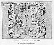
Cartographer Samuel de Champlain
Samuel de Champlain
Samuel de Champlain , "The Father of New France", was a French navigator, cartographer, draughtsman, soldier, explorer, geographer, ethnologist, diplomat, and chronicler. He founded New France and Quebec City on July 3, 1608....
was part of the Dugua expedition and settlement on the small river island in 1604. The following spring, Champlain and François Gravé Du Pont
François Gravé Du Pont
François Gravé , said Du Pont , was a French navigator , an early fur trader and explorer in the New World.Gravé Du Pont is known to have traded furs in the New France, since maybe 1580, surely before 1599, reaching Trois-Rivières in...
, moved the settlement to a new location on the southern shore of the Bay of Fundy
Bay of Fundy
The Bay of Fundy is a bay on the Atlantic coast of North America, on the northeast end of the Gulf of Maine between the Canadian provinces of New Brunswick and Nova Scotia, with a small portion touching the U.S. state of Maine...
called Port-Royal
Habitation at Port-Royal
The Habitation at Port-Royal was the first successful French settlement of New France in North America, and is presently known as Port-Royal National Historic Site, a National Historic Site located on the northern side of the Annapolis Basin, Nova Scotia, Canada...
. During the winter more than half the settlers had perished due to a "land-sickness" believed to be scurvy
Scurvy
Scurvy is a disease resulting from a deficiency of vitamin C, which is required for the synthesis of collagen in humans. The chemical name for vitamin C, ascorbic acid, is derived from the Latin name of scurvy, scorbutus, which also provides the adjective scorbutic...
. Champlain had discovered this new location earlier in the spring during a shoreline reconnaissance of the Bay of Fundy for a more suitable settlement site.
In 1608, Samuel de Champlain and some of the settlers moved from Port-Royal to a settlement on the Saint Lawrence River
Saint Lawrence River
The Saint Lawrence is a large river flowing approximately from southwest to northeast in the middle latitudes of North America, connecting the Great Lakes with the Atlantic Ocean. It is the primary drainage conveyor of the Great Lakes Basin...
that later became Québec
Quebec City
Quebec , also Québec, Quebec City or Québec City is the capital of the Canadian province of Quebec and is located within the Capitale-Nationale region. It is the second most populous city in Quebec after Montreal, which is about to the southwest...
.
In October 1613, after having burned the French mission at Mount Desert Island
Mount Desert Island
Mount Desert Island , in Hancock County, Maine, is the largest island off the coast of Maine. With an area of it is the 6th largest island in the contiguous United States. Though it is often claimed to be the third largest island on the eastern seaboard of the United States, it is actually second...
, Samuel Argall
Samuel Argall
Sir Samuel Argall was an English adventurer and naval officer.As a sea captain, in 1609, Argall was the first to determine a shorter northern route from England across the Atlantic Ocean to the new English colony of Virginia, based at Jamestown, and made numerous voyages to the New World...
went on to burn the old French buildings that remained on Sainte-Croix before he moved on to raid Port Royal, Nova Scotia
Port Royal, Nova Scotia
Port Royal was the capital of Acadia from 1605 to 1710 and is now a town called Annapolis Royal in the western part of the Canadian province of Nova Scotia. Initially Port Royal was located on the north shore of the Annapolis Basin, Nova Scotia, at the site of the present reconstruction of the...
.
Heritage of St. Croix Island
During a boundary dispute between BritainKingdom of Great Britain
The former Kingdom of Great Britain, sometimes described as the 'United Kingdom of Great Britain', That the Two Kingdoms of Scotland and England, shall upon the 1st May next ensuing the date hereof, and forever after, be United into One Kingdom by the Name of GREAT BRITAIN. was a sovereign...
and the U.S. in 1797, the island was deemed to be under U.S. sovereignty by a survey of the river which determined it to be on the western side of the main river channel.
It became known as Bone Island in the 18th century after many of the graves were exposed by erosion. 23 sets of remains were removed in 1969 and subsequently reburied in 2003. Analysis of the bones showed that many of them had indications of scurvy, confirming the cause of the deaths described by Champlain. One skull showed signs of having been autopsied which Champlain wrote that he had ordered to try to discover the cause of their illness.
The island was neutral territory in the War of 1812
War of 1812
The War of 1812 was a military conflict fought between the forces of the United States of America and those of the British Empire. The Americans declared war in 1812 for several reasons, including trade restrictions because of Britain's ongoing war with France, impressment of American merchant...
, leading it to be sometimes called Neutral Island.
Named by the French, Ile Ste-Croix, the island has also been called Demont's Island and Doucett Island.
International Historic Site
In the United States, the island was designated Saint Croix Island National Monument by the United States Congress in 1949. The monument was listed on the National Register of Historic PlacesNational Register of Historic Places
The National Register of Historic Places is the United States government's official list of districts, sites, buildings, structures, and objects deemed worthy of preservation...
on October 15, 1966. It was given its current designation by Congress as an International Historic Site
National Historical Park
National Historic Sites are protected areas of national historic significance in the United States. A National Historic Site usually contains a single historical feature directly associated with its subject...
on September 25, 1984, a unique designation in the national park systems of the United States and Canada. Since 1968, the island has been managed by the National Park Service
National Park Service
The National Park Service is the U.S. federal agency that manages all national parks, many national monuments, and other conservation and historical properties with various title designations...
from offices at Acadia National Park
Acadia National Park
Acadia National Park is a National Park located in the U.S. state of Maine. It reserves much of Mount Desert Island, and associated smaller islands, off the Atlantic coast...
, the nearest staffed U.S. national park unit, in consultation with Parks Canada
Parks Canada
Parks Canada , also known as the Parks Canada Agency , is an agency of the Government of Canada mandated to protect and present nationally significant natural and cultural heritage, and foster public understanding, appreciation, and enjoyment in ways that ensure their ecological and commemorative...
, which maintains a viewing and interpretation site on the New Brunswick side of the river.
In Canada, the island was first recognized in 1958 by the Historic Sites and Monuments Board (HSMB) as having national historic significance. It recommended creation of Dochet Island National Historic Site, but this was rejected by the government on the basis that its location fell outside national jurisdiction. A decade later, in 1968, the HSMB reiterated the site's significance, suggesting Parks Canada "...cooperate with the United States National Parks [sic] Service in the development of the island as an Historic Park." This was approved, and today Parks Canada operates St. Croix Island International Historic Site at Bayside, New Brunswick
Bayside, New Brunswick
Bayside is a community in the Canadian province of New Brunswick....
, a site overlooking the island, similar to the U.S. approach to the site's interpretation.
The two nations routinely cooperate on commemorative activities and promotions. Special commemorations by the two nations in 2004 marked the 400th anniversary of French settlement in North America. In 2009, the site started offering a full French translation of its U.S. website, offered by teen volunteer Olivier Fontenelle. Its Parks Canada website, like all others in its network, has been offered in French since first appearing online.
The HSMB designates three categories of commemoration: nationally significant Sites, Events, and Persons. While the HSMB had recommended Dochet Island National Historic Site in 1958, it was unclear whether the HSMB's later recommendation, in 1968, was to name it a Site or an Event. This was clarified in 2008. Relying on a 1960 HSMB decision that naming national historic sites outside Canada should be avoided, and in light of policy that Events and Persons outside the country may be designated, it decided that Dochet Island had been designated a national historic event in 1968.
However, since the 1968 designation was approved under the name "St. Croix Island", and this was the name used in the international agreement, the HSMB's Status of Designations Committee confirmed the official name of the designation which had referred to Dochet Island would be "Ste. Croix Island".
External links
- Parks Canada: Saint Croix Island International Historic Site
- National Park Service: Saint Croix Island International Historic Site
- Sainte-Croix 2004
- Île Sainte-Croix
- St. Croix Island History (From the Internet ArchiveInternet ArchiveThe Internet Archive is a non-profit digital library with the stated mission of "universal access to all knowledge". It offers permanent storage and access to collections of digitized materials, including websites, music, moving images, and nearly 3 million public domain books. The Internet Archive...
) - St-Croix: 1604-2004
- Life After Ile Ste-Croix