
.gif)
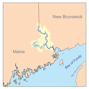
St. Croix River (Maine-New Brunswick)
Encyclopedia
Maine
Maine is a state in the New England region of the northeastern United States, bordered by the Atlantic Ocean to the east and south, New Hampshire to the west, and the Canadian provinces of Quebec to the northwest and New Brunswick to the northeast. Maine is both the northernmost and easternmost...
(U.S.) and New Brunswick
New Brunswick
New Brunswick is one of Canada's three Maritime provinces and is the only province in the federation that is constitutionally bilingual . The provincial capital is Fredericton and Saint John is the most populous city. Greater Moncton is the largest Census Metropolitan Area...
(Canada). The river rises in the Chiputneticook Lakes
Chiputneticook Lakes
The Chipnuneticook Lakes are a group of several lakes along the International Boundary between Maine and New Brunswick.They are East Grand Lake, North Lake, Mud Lake, Spednic Lake, and Palfrey Lake.This lake system forms the head waters of the St...
and flows south and southeast, between Calais
Calais, Maine
Calais is a city in Washington County, Maine, United States. The city has three United States border crossings or also known as a Port of entry with the busiest being on the St. Croix River bordering St. Stephen, New Brunswick, Canada...
and St. Stephen
St. Stephen, New Brunswick
St. Stephen is a Canadian town in Charlotte County, New Brunswick, situated on the east bank of the St. Croix River at .-Climate:...
. It discharges into Passamaquoddy Bay
Passamaquoddy Bay
Passamaquoddy Bay is an inlet of the Bay of Fundy, between the U.S. state of Maine and the Canadian province of New Brunswick, at the mouth of the St. Croix River. Most of the bay lies within Canada, with its western shore bounded by Washington County, Maine. The southernmost point is formed by...
, in the Bay of Fundy
Bay of Fundy
The Bay of Fundy is a bay on the Atlantic coast of North America, on the northeast end of the Gulf of Maine between the Canadian provinces of New Brunswick and Nova Scotia, with a small portion touching the U.S. state of Maine...
.
Geography
The river forms from the Chiputneticook Lakes (North Lake, Grand Lake, Mud Lake, and Spednic LakeSpednic Lake
Spednic Lake is a mesotrophic lake in the Chiputneticook Lakes chain along the Canada – United States border between the state of Maine and the province of New Brunswick that is best known for its bass fishing. Sometimes it is viewed as the headwaters of the St...
) along the Canadian - U.S. border. US Geological Survey topographic maps show the St. Croix River as beginning at the 1 miles (1.6 km) outlet stream from Grand Lake, then flowing through the short Mud Lake and entering Spednic Lake, extending 20 miles (32.2 km) to its outlet at Vanceboro, Maine
Vanceboro, Maine
Vanceboro is a town in Washington County, Maine, United States. The town was named after landowner William Vance. The town is located at the eastern terminus of Maine State Route 6. Vanceboro is across the St. Croix River from St. Croix, New Brunswick, Canada, to which it is connected by the Saint...
, and the start of the river proper. Adding the section of river and lake from the outlet of Grand Lake gives a total length of 95 miles (152.9 km) to the St. Croix.
The total drainage area of the river is approximately 1500 square miles (3,885 km²). In the 20th century, the river was heavily developed for hydroelectric power. The river had previously hosted a large population of Atlantic salmon
Atlantic salmon
The Atlantic salmon is a species of fish in the family Salmonidae, which is found in the northern Atlantic Ocean and in rivers that flow into the north Atlantic and the north Pacific....
; however, the salmon population was reduced after building hydroelectric dams upriver from Calais-St. Stephen.
The river is an estuary
Estuary
An estuary is a partly enclosed coastal body of water with one or more rivers or streams flowing into it, and with a free connection to the open sea....
between Calais-St. Stephen and the river's mouth at Robbinston
Robbinston, Maine
Robbinston is a town in Washington County, Maine, United States. The population was 525 at the 2000 census.-Geography:According to the United States Census Bureau, the town has a total area of , of which, of it is land and of it is water....
and St. Andrews
St. Andrews, New Brunswick
St. Andrews is a Canadian town in Charlotte County, New Brunswick.It is sometimes referred to in tourism marketing by its unofficial nickname "St. Andrews-by-the-sea".-Geography:St...
. This tidal area extends for approximately 25 kilometres (15.5 mi) along this section and exhibits a tidal bore
Tidal bore
A tidal bore is a tidal phenomenon in which the leading edge of the incoming tide forms a wave of water that travel up a river or narrow bay against the direction of the river or bay's current...
.
Canada
The Water Survey of CanadaWater Survey of Canada
The Water Survey of Canada is a scientific branch of Canada's Department of the Environment that is responsible for monitoring the nation's freshwater resources....
maintains six river flow gauges in the St. Croix River watershed:
- St. Croix, New Brunswick (45.5689°N 67.4297°W)
- Baring, MaineBaring, MaineBaring Plantation is a plantation in Washington County, Maine, United States. The population was 273 at the 2000 census. The plantation is named for Alexander Baring, 1st Baron Ashburton, the British negotiator of the Webster-Ashburton Treaty which ended the Aroostook War in...
(45.1367°N 67.3181°W) - Dennis Stream near St. Stephen, New BrunswickSt. Stephen, New BrunswickSt. Stephen is a Canadian town in Charlotte County, New Brunswick, situated on the east bank of the St. Croix River at .-Climate:...
(45.2097°N 67.2625°W - Grand Lake at Forest City, New BrunswickForest City, New BrunswickForest City is a Canadian rural community in York County, New Brunswick.The community has the unique distinction of sharing its name with the community of Forest City immediately across the International Boundary in the state of Maine....
(45.6650°N 67.7361°W) - Spednic LakeSpednic LakeSpednic Lake is a mesotrophic lake in the Chiputneticook Lakes chain along the Canada – United States border between the state of Maine and the province of New Brunswick that is best known for its bass fishing. Sometimes it is viewed as the headwaters of the St...
at St. Croix, New Brunswick (45.5692°N 67.4281°W) - Forest CityForest City-Places names:Canada*Forest City, New BrunswickUnited States*Forest City, Florida*Forest City, Illinois*Forest City, Indiana*Forest City, Iowa** Forest City meteorite of 1890, which fell in Iowa, *Forest City, Maine...
Stream, below the Forest CityForest City-Places names:Canada*Forest City, New BrunswickUnited States*Forest City, Florida*Forest City, Illinois*Forest City, Indiana*Forest City, Iowa** Forest City meteorite of 1890, which fell in Iowa, *Forest City, Maine...
Dam at Forest City, New BrunswickForest City, New BrunswickForest City is a Canadian rural community in York County, New Brunswick.The community has the unique distinction of sharing its name with the community of Forest City immediately across the International Boundary in the state of Maine....
(45.6642°N 67.7344°W)
United States
The United States Geological SurveyUnited States Geological Survey
The United States Geological Survey is a scientific agency of the United States government. The scientists of the USGS study the landscape of the United States, its natural resources, and the natural hazards that threaten it. The organization has four major science disciplines, concerning biology,...
maintains two river flow gages in the St. Croix River watershed.
- Vanceboro, MaineVanceboro, MaineVanceboro is a town in Washington County, Maine, United States. The town was named after landowner William Vance. The town is located at the eastern terminus of Maine State Route 6. Vanceboro is across the St. Croix River from St. Croix, New Brunswick, Canada, to which it is connected by the Saint...
(45°34′08"N 67°25′47"W) where the rivershed is 413 square miles (1,069.7 km²), 400 feet (121.9 m) downstream from the Spednik Lake Dam.
- Baring Plantation, Maine (45°34′08"N 67°25′47"W) where the rivershed is 1374 square miles (3,558.6 km²), 5.6 miles (9 km) downstream of the nearest dam. The maximum recorded flow here is 23500 cubic feet (665.4 m³) per second and the minimum 262 cubic feet (7.4 m³) per second.
USGS also maintains a water chemistry monitor at Milltown, Maine (45°10′11"N 67°17′50"W) where the rivershed is 1455 square miles (3,768.4 km²). For water year 2001, the pH
PH
In chemistry, pH is a measure of the acidity or basicity of an aqueous solution. Pure water is said to be neutral, with a pH close to 7.0 at . Solutions with a pH less than 7 are said to be acidic and solutions with a pH greater than 7 are basic or alkaline...
ranged from 6.6 to 7.2.
Crossings
Seven active international bridgeInternational Bridge
The following bridges are known as the International Bridge:*International Railway Bridge, a railroad bridge at Buffalo, New York*Baudette-Rainy River International Bridge, connecting Rainy River, Ontario and Baudette, Minnesota...
s cross the river at the following locations:
- St. Croix, New Brunswick-Vanceboro, MaineVanceboro, MaineVanceboro is a town in Washington County, Maine, United States. The town was named after landowner William Vance. The town is located at the eastern terminus of Maine State Route 6. Vanceboro is across the St. Croix River from St. Croix, New Brunswick, Canada, to which it is connected by the Saint...
(Saint Croix-Vanceboro BridgeSaint Croix-Vanceboro BridgeThe Saint Croix – Vanceboro Bridge is an international bridge, which connects the communities of Saint Croix, New Brunswick in Canada and Vanceboro, Maine in the United States, across the St. Croix River...
, road - St. Croix-Vanceboro (New Brunswick Southern RailwayNew Brunswick Southern RailwayThe New Brunswick Southern Railway and Eastern Maine Railway form a 189-mile railway system operating a former Canadian Pacific Railway mainline between Saint John, New Brunswick and Brownville Junction, Maine....
), rail - Mohannes, New Brunswick-Woodland, MaineWoodland, MaineWoodland is the name of some places in the U.S. state of Maine:*Woodland, Aroostook County, Maine*Woodland, Washington County, Maine...
(Maine Central RailroadMaine Central RailroadThe Maine Central Railroad Company was a railroad in central and southern Maine. It was chartered in 1856 and began operations in 1862. It operated a mainline between South Portland, Maine, east to the Canada-U.S...
), rail - Upper Mills, New Brunswick-Baring, MaineBaring, MaineBaring Plantation is a plantation in Washington County, Maine, United States. The population was 273 at the 2000 census. The plantation is named for Alexander Baring, 1st Baron Ashburton, the British negotiator of the Webster-Ashburton Treaty which ended the Aroostook War in...
(Maine Central RailroadMaine Central RailroadThe Maine Central Railroad Company was a railroad in central and southern Maine. It was chartered in 1856 and began operations in 1862. It operated a mainline between South Portland, Maine, east to the Canada-U.S...
), rail - St. Stephen, New BrunswickSt. Stephen, New BrunswickSt. Stephen is a Canadian town in Charlotte County, New Brunswick, situated on the east bank of the St. Croix River at .-Climate:...
-Calais, MaineCalais, MaineCalais is a city in Washington County, Maine, United States. The city has three United States border crossings or also known as a Port of entry with the busiest being on the St. Croix River bordering St. Stephen, New Brunswick, Canada...
, road (opened November 16, 2009) - St. Stephen, New BrunswickSt. Stephen, New BrunswickSt. Stephen is a Canadian town in Charlotte County, New Brunswick, situated on the east bank of the St. Croix River at .-Climate:...
-Calais, MaineCalais, MaineCalais is a city in Washington County, Maine, United States. The city has three United States border crossings or also known as a Port of entry with the busiest being on the St. Croix River bordering St. Stephen, New Brunswick, Canada...
(Milltown International BridgeMilltown International BridgeThe Milltown International Bridge is an international bridge, which connects St. Stephen, New Brunswick in Canada and Calais, Maine in the United States, across the St. Croix River....
), road - St. Stephen, New BrunswickSt. Stephen, New BrunswickSt. Stephen is a Canadian town in Charlotte County, New Brunswick, situated on the east bank of the St. Croix River at .-Climate:...
-Calais, MaineCalais, MaineCalais is a city in Washington County, Maine, United States. The city has three United States border crossings or also known as a Port of entry with the busiest being on the St. Croix River bordering St. Stephen, New Brunswick, Canada...
(New Brunswick Southern RailwayNew Brunswick Southern RailwayThe New Brunswick Southern Railway and Eastern Maine Railway form a 189-mile railway system operating a former Canadian Pacific Railway mainline between Saint John, New Brunswick and Brownville Junction, Maine....
/Maine Central RailroadMaine Central RailroadThe Maine Central Railroad Company was a railroad in central and southern Maine. It was chartered in 1856 and began operations in 1862. It operated a mainline between South Portland, Maine, east to the Canada-U.S...
), rail - St. Stephen, New BrunswickSt. Stephen, New BrunswickSt. Stephen is a Canadian town in Charlotte County, New Brunswick, situated on the east bank of the St. Croix River at .-Climate:...
-Calais, MaineCalais, MaineCalais is a city in Washington County, Maine, United States. The city has three United States border crossings or also known as a Port of entry with the busiest being on the St. Croix River bordering St. Stephen, New Brunswick, Canada...
(St. Stephen-Calais BridgeSt. Stephen-Calais BridgeThe Ferry Point International Bridge is an international bridge, which connects St. Stephen, New Brunswick in Canada and Calais, Maine in the United States, across the St. Croix River.St...
), road
One defunct crossing exists:
- St. Stephen, New BrunswickSt. Stephen, New BrunswickSt. Stephen is a Canadian town in Charlotte County, New Brunswick, situated on the east bank of the St. Croix River at .-Climate:...
-Calais, MaineCalais, MaineCalais is a city in Washington County, Maine, United States. The city has three United States border crossings or also known as a Port of entry with the busiest being on the St. Croix River bordering St. Stephen, New Brunswick, Canada...
, ferry (at site of St. Stephen-Calais BridgeSt. Stephen-Calais BridgeThe Ferry Point International Bridge is an international bridge, which connects St. Stephen, New Brunswick in Canada and Calais, Maine in the United States, across the St. Croix River.St...
)
Derived names
HMCS St. Croix (I81)USS McCook (DD-252)
The first USS McCook was a Clemson-class destroyer in the United States Navy. She transferred to the Royal Navy and then to the Royal Canadian Navy as HMCS St. Croix during World War II.- As USS McCook :...
, previously USS McCook (DD-252), became a Canadian ship in 1940 as part of the Destroyers for Bases Agreement
Destroyers for Bases Agreement
The Destroyers for Bases Agreement between the United States and the United Kingdom, September 2, 1940, transferred fifty mothballed destroyers from the United States Navy in exchange for land rights on British possessions...
. It was renamed after the St. Croix River to follow the Canadian tradition of naming destroyer
Destroyer
In naval terminology, a destroyer is a fast and maneuverable yet long-endurance warship intended to escort larger vessels in a fleet, convoy or battle group and defend them against smaller, powerful, short-range attackers. Destroyers, originally called torpedo-boat destroyers in 1892, evolved from...
s after Canadian rivers while recognizing the shared national history of the ship.