

Royal Charter Storm
Encyclopedia
The Royal Charter Storm of 25 and 26 October 1859 was considered to be the most severe storm to hit the British Isles
in the 19th century, with a total death toll estimated at over 800. It takes its name from the Royal Charter
ship, which was driven by the storm onto the east coast of Anglesey
, Wales
with the loss of over 450 lives.
The storm followed several days of unsettled weather. The first indications were seen in the English Channel
about 3 p.m. on the 25 October 1859, when there was a sudden increase in wind speed and a shift in its direction. There was extensive structural damage along the coasts of Devon
and Cornwall
. The storm drifted northwards, hitting Anglesey
by about 8 p.m. and not reaching maximum force at the River Mersey
until midday on 26 October, then continued northwards to affect Scotland
. The winds reached force 12 on the Beaufort scale
and were well over 100 mph (44.7 m/s). At the Mersey a wind force of 28 lbs to the square foot (14 N per 100 mm) was measured, more than ever previously recorded.
 On the north coast of Anglesey
, where the Royal Charter
, a steam clipper
, was approaching the end of her voyage from Melbourne
to Liverpool
, the wind at Point Lynas
changed direction to ENE at 10 p.m. on 25 October and rose to gale force. By 10 p.m. the wind had reached force 10 and continued to increase, reaching force 12 by midnight. It continued to blow at force 12 until the afternoon of 26 October.
The Royal Charter was driven ashore on the east coast of Anglesey just north of the village of Moelfre
in the early hours of the morning of 26 October 1859, eventually being smashed to pieces against the rocks, with the loss of over 450 lives. The public impact of the shipwreck may be judged by the fact that Charles Dickens
travelled from London to Anglesey to report on the aftermath as described in The Uncommercial Traveller
.
A total of 133 ships were sunk during the storm and another 90 badly damaged according to the Board of Trade
records. The death toll was estimated at around 800, including some people killed on land by falling rocks and masonry. Twice as many people died in these two days as had been lost at sea around the British Isles in the whole of 1858. There was extensive structural damage to many buildings, with the west coast of Great Britain
being most severely affected. The remains of the church of Saint Brynach may still be seen at Cwm-yr-Eglwys in Pembrokeshire
.
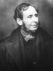
This storm had an effect on the development of the Meteorological Office as Captain Robert FitzRoy
, who was in charge of the office at the time, brought in the first gale warning
service in 1860 to prevent similar tragedies.
British Isles
The British Isles are a group of islands off the northwest coast of continental Europe that include the islands of Great Britain and Ireland and over six thousand smaller isles. There are two sovereign states located on the islands: the United Kingdom of Great Britain and Northern Ireland and...
in the 19th century, with a total death toll estimated at over 800. It takes its name from the Royal Charter
Royal Charter (ship)
The Royal Charter was a steam clipper which was wrecked off the beach of Porth Alerth in Dulas Bay on the north-east coast of Anglesey on 26 October 1859. The precise number of dead is uncertain as the passenger list was lost in the wreck but about 459 lives were lost, the highest death toll of any...
ship, which was driven by the storm onto the east coast of Anglesey
Anglesey
Anglesey , also known by its Welsh name Ynys Môn , is an island and, as Isle of Anglesey, a county off the north west coast of Wales...
, Wales
Wales
Wales is a country that is part of the United Kingdom and the island of Great Britain, bordered by England to its east and the Atlantic Ocean and Irish Sea to its west. It has a population of three million, and a total area of 20,779 km²...
with the loss of over 450 lives.
The storm followed several days of unsettled weather. The first indications were seen in the English Channel
English Channel
The English Channel , often referred to simply as the Channel, is an arm of the Atlantic Ocean that separates southern England from northern France, and joins the North Sea to the Atlantic. It is about long and varies in width from at its widest to in the Strait of Dover...
about 3 p.m. on the 25 October 1859, when there was a sudden increase in wind speed and a shift in its direction. There was extensive structural damage along the coasts of Devon
Devon
Devon is a large county in southwestern England. The county is sometimes referred to as Devonshire, although the term is rarely used inside the county itself as the county has never been officially "shired", it often indicates a traditional or historical context.The county shares borders with...
and Cornwall
Cornwall
Cornwall is a unitary authority and ceremonial county of England, within the United Kingdom. It is bordered to the north and west by the Celtic Sea, to the south by the English Channel, and to the east by the county of Devon, over the River Tamar. Cornwall has a population of , and covers an area of...
. The storm drifted northwards, hitting Anglesey
Anglesey
Anglesey , also known by its Welsh name Ynys Môn , is an island and, as Isle of Anglesey, a county off the north west coast of Wales...
by about 8 p.m. and not reaching maximum force at the River Mersey
River Mersey
The River Mersey is a river in North West England. It is around long, stretching from Stockport, Greater Manchester, and ending at Liverpool Bay, Merseyside. For centuries, it formed part of the ancient county divide between Lancashire and Cheshire....
until midday on 26 October, then continued northwards to affect Scotland
Scotland
Scotland is a country that is part of the United Kingdom. Occupying the northern third of the island of Great Britain, it shares a border with England to the south and is bounded by the North Sea to the east, the Atlantic Ocean to the north and west, and the North Channel and Irish Sea to the...
. The winds reached force 12 on the Beaufort scale
Beaufort scale
The Beaufort Scale is an empirical measure that relates wind speed to observed conditions at sea or on land. Its full name is the Beaufort Wind Force Scale.-History:...
and were well over 100 mph (44.7 m/s). At the Mersey a wind force of 28 lbs to the square foot (14 N per 100 mm) was measured, more than ever previously recorded.
Royal Charter shipwreck
Anglesey
Anglesey , also known by its Welsh name Ynys Môn , is an island and, as Isle of Anglesey, a county off the north west coast of Wales...
, where the Royal Charter
Royal Charter (ship)
The Royal Charter was a steam clipper which was wrecked off the beach of Porth Alerth in Dulas Bay on the north-east coast of Anglesey on 26 October 1859. The precise number of dead is uncertain as the passenger list was lost in the wreck but about 459 lives were lost, the highest death toll of any...
, a steam clipper
Clipper
A clipper was a very fast sailing ship of the 19th century that had three or more masts and a square rig. They were generally narrow for their length, could carry limited bulk freight, small by later 19th century standards, and had a large total sail area...
, was approaching the end of her voyage from Melbourne
Melbourne
Melbourne is the capital and most populous city in the state of Victoria, and the second most populous city in Australia. The Melbourne City Centre is the hub of the greater metropolitan area and the Census statistical division—of which "Melbourne" is the common name. As of June 2009, the greater...
to Liverpool
Liverpool
Liverpool is a city and metropolitan borough of Merseyside, England, along the eastern side of the Mersey Estuary. It was founded as a borough in 1207 and was granted city status in 1880...
, the wind at Point Lynas
Point Lynas Lighthouse
Point Lynas Lighthouse is located on the north coast of Anglesey in North Wales .-Construction:This unusual and distinctive lighthouse was designed by Jesse Hartley, engineer to the Mersey Docks and Harbour Board from 1824 to 1860, but with additions by G Lyster some twenty years later.It is a...
changed direction to ENE at 10 p.m. on 25 October and rose to gale force. By 10 p.m. the wind had reached force 10 and continued to increase, reaching force 12 by midnight. It continued to blow at force 12 until the afternoon of 26 October.
The Royal Charter was driven ashore on the east coast of Anglesey just north of the village of Moelfre
Moelfre
Moelfre is a village and community on the east coast of Isle of Anglesey in Wales, and on the Anglesey Coastal Path. It has a population of 1,129.The Royal Mail postcode begins LL72....
in the early hours of the morning of 26 October 1859, eventually being smashed to pieces against the rocks, with the loss of over 450 lives. The public impact of the shipwreck may be judged by the fact that Charles Dickens
Charles Dickens
Charles John Huffam Dickens was an English novelist, generally considered the greatest of the Victorian period. Dickens enjoyed a wider popularity and fame than had any previous author during his lifetime, and he remains popular, having been responsible for some of English literature's most iconic...
travelled from London to Anglesey to report on the aftermath as described in The Uncommercial Traveller
The Uncommercial Traveller
The Uncommercial Traveller is a collection of literary sketches and reminiscences written by Charles Dickens.In 1859 Dickens founded a new journal called All the Year Round and the Uncommercial Traveller articles would be among his main contributions...
.
A total of 133 ships were sunk during the storm and another 90 badly damaged according to the Board of Trade
Board of Trade
The Board of Trade is a committee of the Privy Council of the United Kingdom, originating as a committee of inquiry in the 17th century and evolving gradually into a government department with a diverse range of functions...
records. The death toll was estimated at around 800, including some people killed on land by falling rocks and masonry. Twice as many people died in these two days as had been lost at sea around the British Isles in the whole of 1858. There was extensive structural damage to many buildings, with the west coast of Great Britain
Great Britain
Great Britain or Britain is an island situated to the northwest of Continental Europe. It is the ninth largest island in the world, and the largest European island, as well as the largest of the British Isles...
being most severely affected. The remains of the church of Saint Brynach may still be seen at Cwm-yr-Eglwys in Pembrokeshire
Pembrokeshire
Pembrokeshire is a county in the south west of Wales. It borders Carmarthenshire to the east and Ceredigion to the north east. The county town is Haverfordwest where Pembrokeshire County Council is headquartered....
.
This storm had an effect on the development of the Meteorological Office as Captain Robert FitzRoy
Robert FitzRoy
Vice-Admiral Robert FitzRoy RN achieved lasting fame as the captain of HMS Beagle during Charles Darwin's famous voyage, and as a pioneering meteorologist who made accurate weather forecasting a reality...
, who was in charge of the office at the time, brought in the first gale warning
Gale warning
A gale warning is a warning issued by weather services in maritime locations about the existence of winds of gale force or above or the imminent occurrence of gales at sea...
service in 1860 to prevent similar tragedies.