
.gif)
Route 2 (Hong Kong)
Encyclopedia
Route 2 of Hong Kong
runs from Quarry Bay
of Hong Kong Island
to Ma Liu Shui
of the New Territories
, formerly known as route 6, and renamed as route 2 in 2004 under the route numbering scheme proposed in the same year.
 Route 2 consists of 4 parts, from South to North:
Hong Kong
Hong Kong is one of two Special Administrative Regions of the People's Republic of China , the other being Macau. A city-state situated on China's south coast and enclosed by the Pearl River Delta and South China Sea, it is renowned for its expansive skyline and deep natural harbour...
runs from Quarry Bay
Quarry Bay
Quarry Bay is an area beneath Mount Parker in the Eastern District of Hong Kong Island, in Hong Kong. The western portion of the area was also formerly known as Lai Chi...
of Hong Kong Island
Hong Kong Island
Hong Kong Island is an island in the southern part of the Hong Kong Special Administrative Region. It has a population of 1,289,500 and its population density is 16,390/km², as of 2008...
to Ma Liu Shui
Ma Liu Shui
Ma Liu Shui or originally Ma Niu Shui is an area in Sha Tin District, in the New Territories, Hong Kong.The area faces Tide Cove and Tolo Harbour...
of the New Territories
New Territories
New Territories is one of the three main regions of Hong Kong, alongside Hong Kong Island and the Kowloon Peninsula. It makes up 86.2% of Hong Kong's territory. Historically, it is the region described in The Convention for the Extension of Hong Kong Territory...
, formerly known as route 6, and renamed as route 2 in 2004 under the route numbering scheme proposed in the same year.
- Eastern Harbour CrossingEastern Harbour CrossingThe Eastern Harbour Crossing, abbreviated as "EHC" , is a tunnel in Hong Kong. It is a combined road and MTR rail link under Victoria Harbour between Quarry Bay in Hong Kong Island and Cha Kwo Ling in Kowloon.- History :...
starting from Quarry BayQuarry BayQuarry Bay is an area beneath Mount Parker in the Eastern District of Hong Kong Island, in Hong Kong. The western portion of the area was also formerly known as Lai Chi...
, where it joins into Island Eastern CorridorIsland Eastern CorridorIsland Eastern Corridor is an expressway along the north shore of Hong Kong Island in Hong Kong. It starts from Causeway Bay in the west and ends in Chai Wan in the east. It is part of Route 4...
of Route 4Route 4 (Hong Kong)Route 4 is an east-west road artery along the north shore of Hong Kong Island, Hong Kong. Formerly divided into routes 7 and 8, Route 4 consists of two sections:...
, across the Victoria HarbourVictoria HarbourVictoria Harbour is a natural landform harbour situated between Hong Kong Island and the Kowloon Peninsula in Hong Kong. The harbour's deep, sheltered waters and strategic location on the South China Sea were instrumental in Hong Kong's establishment as a British colony and its subsequent...
and ending at Lam TinLam TinLam Tin is an area in the Kwun Tong District in southeastern New Kowloon, Hong Kong. Lam Tin is primarily a residential area, though it also hosts a major transport interchange and the location of several renowned shopping attractions. Lam Tin was once a large field in the vicinity of Kowloon Bay....
. Exit 1 is present in the starting point; exit 2 is present around Lei Yue Mun Interchange. - Kwun Tong BypassKwun Tong BypassKwun Tong Bypass is an elevated bypass expressway in Kwun Tong, Kowloon, Hong Kong with three lanes in each direction and a posted speed limit of 70-80 kilometres per hour. It comprises part of Route 2 and has links to Route 5 and Route 7....
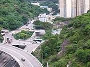
succeeds the EHC at Lei Yue Mun InterchangeLei Yue Mun InterchangeLei Yue Mun Interchange is a roundabout interchange that feeds traffic from Eastern Harbour Crossing , to Yau Tong and Lam Tin via Lei Yue Mun Road & Kai Tin Road, respectively, and to/from Route 7....
and goes along the coastCoastA coastline or seashore is the area where land meets the sea or ocean. A precise line that can be called a coastline cannot be determined due to the dynamic nature of tides. The term "coastal zone" can be used instead, which is a spatial zone where interaction of the sea and land processes occurs...
of Kowloon BayKowloon BayKowloon Bay is a bay located at the east of the Kowloon Peninsula and north of Hong Kong Island in Hong Kong. It is the eastern portion of Victoria Harbour, between Hung Hom and Lei Yue Mun...
to Diamond HillDiamond HillDiamond Hill is a hill in Kowloon, Hong Kong. The name also refers to the area on or adjacent to the hill. It is surrounded by Ngau Chi Wan, San Po Kong, Wong Tai Sin and Tsz Wan Shan. Its northeast is limited by the ridge. It is principally a residential district.-Etymology:Contrary to its name,...
. On the Kwun Tong BypassKwun Tong BypassKwun Tong Bypass is an elevated bypass expressway in Kwun Tong, Kowloon, Hong Kong with three lanes in each direction and a posted speed limit of 70-80 kilometres per hour. It comprises part of Route 2 and has links to Route 5 and Route 7....
, Route 2 junctions Route 5Route 5 (Hong Kong)Route 5 is a route artery in Hong Kong from eastern to western Kowloon and New Kowloon, and ends in Tsuen Wan in the New Territories, linking Route 9....
and Route 7Route 7 (Hong Kong)Route 7 is a highway route running through New Kowloon in Hong Kong between Tseung Kwan O and Kwai Chung.The first sections of road were built as a 5 lane trunk road , it was expanded to the current 6 lane highway...
. Exit 3 is at Kowloon Bay which leads to Route 5 and the Kowloon Bay Industrial Area; exit 4 joins the Prince Edward RoadPrince Edward RoadPrince Edward Road East and Prince Edward Road West are roads in Kowloon, Hong Kong, going in an east-west direction and linking Tai Kok Tsui, Mong Kok, Kowloon Tong, Kowloon City and San Po Kong ....
at the entrance of Tate's Cairn Tunnel. - Tate's Cairn TunnelTate's Cairn TunnelTate's Cairn Tunnel is a four-lane tunnel in Hong Kong. Constructed as part of Route 2, it links Diamond Hill, Eastern Kowloon and Siu Lek Yuen, Sha Tin in the New Territories. It was opened on 26th June 1991....
continues the route from Diamond HillDiamond HillDiamond Hill is a hill in Kowloon, Hong Kong. The name also refers to the area on or adjacent to the hill. It is surrounded by Ngau Chi Wan, San Po Kong, Wong Tai Sin and Tsz Wan Shan. Its northeast is limited by the ridge. It is principally a residential district.-Etymology:Contrary to its name,...
, cutting through Tate's CairnTate's CairnTate's Cairn is one of many mountain peaks in Hong Kong. The peak is 583 metres in height. It is a member of the Kowloon Ridge and within Ma On Shan Country Park.The name is used by a tunnel that travels under the peak...
to Shek Mun InterchangeShek Mun InterchangeShek Mun Interchange is an interchange which feeds traffic from Tate's Cairn Highway with Tai Chung Kiu Road in the New Territories in northern Hong Kong....
. Exit 5 in the section runs down to Siu Lek YuenSiu Lek YuenSiu Lek Yuen is an area in Sha Tin, Hong Kong. To the east of Yuen Chau Kok, the area is surrounded on its three sides by the Ma On Shan Country Park.-Estates:*Castello - a private estate in Siu Lek Yuen...
.
- Tate's Cairn HighwayTate's Cairn HighwayTate's Cairn Highway , opened on June 26, 1991, is a dual-3 lane expressway in Hong Kong. It links Tate's Cairn Tunnel and Ma Liu Shui Interchange, forming a part of Route 2 ....
, at last, takes the route 2 to an end at Ma Liu ShuiMa Liu ShuiMa Liu Shui or originally Ma Niu Shui is an area in Sha Tin District, in the New Territories, Hong Kong.The area faces Tide Cove and Tolo Harbour...
, where it joins into Tolo HighwayTolo HighwayTolo Highway is a major expressway on Route 9 in Hong Kong. It connects the new towns of Sha Tin and Tai Po in the eastern New Territories.The highway diverges from Tai Po Road near Sha Tin Racecourse. The following of the road runs on an embankment on the west coast of Tolo Harbour towards Yuen...
of Route 9Route 9 (Hong Kong)Route 9 , Hong Kong is one of the strategic trunk roads, mostly in the form of an freeway, circumnavigating the New Territories. The route was also known as the New Territories Circular Orbital Beltway Ring Road...
.
Observed roads and exits
| Northbound towards Ma Liu Shui Ma Liu Shui Ma Liu Shui or originally Ma Niu Shui is an area in Sha Tin District, in the New Territories, Hong Kong.The area faces Tide Cove and Tolo Harbour... |
Southbound towards Quarry Bay Quarry Bay Quarry Bay is an area beneath Mount Parker in the Eastern District of Hong Kong Island, in Hong Kong. The western portion of the area was also formerly known as Lai Chi... |
||
| Exit | Destination | Exit | Destination |
| Quarry Bay (Intersection with Route 4 Route 4 (Hong Kong) Route 4 is an east-west road artery along the north shore of Hong Kong Island, Hong Kong. Formerly divided into routes 7 and 8, Route 4 consists of two sections:... ) |
|||
| 1A | Route 4 Route 4 (Hong Kong) Route 4 is an east-west road artery along the north shore of Hong Kong Island, Hong Kong. Formerly divided into routes 7 and 8, Route 4 consists of two sections:... eastbound towards Chai Wan Chai Wan Chai Wan , formerly mistakenly known as Sai Wan , lies at the east end of the urban area of Hong Kong Island next to Shau Kei Wan. The area is administratively part of the Eastern District, and is a mosaic of industrial and residential areas... |
||
| 1B | Route 4 westbound towards Kennedy Town Kennedy Town Kennedy Town is at the western end of Sai Wan on Hong Kong Island in Hong Kong. It was named after Arthur Edward Kennedy, the 7th Governor of Hong Kong from 1872 to 1877... |
||
| Eastern Harbour Tunnel | |||
| Lei Yue Mun Road Lei Yue Mun Road Lei Yue Mun Road is a major road in Lam Tin, Hong Kong. It runs from the junction with Tsui Ping Road and Kwun Tong Road near MTR Kwun Tong Station to the roundabout with Ko Chiu Road near Lei Yue Mun Estate in Yau Tong... |
|||
| 2 | Lam Tin Lam Tin Lam Tin is an area in the Kwun Tong District in southeastern New Kowloon, Hong Kong. Lam Tin is primarily a residential area, though it also hosts a major transport interchange and the location of several renowned shopping attractions. Lam Tin was once a large field in the vicinity of Kowloon Bay.... and Lei Yue Mun Lei Yue Mun Lei Yue Mun is a short channel in Hong Kong, between Junk Bay and Victoria Harbour, separating Kowloon and Hong Kong Island. The channel is an important passage in the South China Sea. It is the east gate of Victoria Harbour.The lands around the channel are also called Lei Yue Mun... |
2 | Lei Yue Mun |
| 2A | Route 7 Route 7 (Hong Kong) Route 7 is a highway route running through New Kowloon in Hong Kong between Tseung Kwan O and Kwai Chung.The first sections of road were built as a 5 lane trunk road , it was expanded to the current 6 lane highway... westbound to Kowloon Bay Kowloon Bay Kowloon Bay is a bay located at the east of the Kowloon Peninsula and north of Hong Kong Island in Hong Kong. It is the eastern portion of Victoria Harbour, between Hung Hom and Lei Yue Mun... and eastbound to Tseung Kwan O Tseung Kwan O Tseung Kwan O is a bay in Sai Kung District, New Territories, Hong Kong. In the northern tip of the bay lies the Tseung Kwan O Village.... |
||
| 2B | Route 7 eastbound to Tseung Kwan O | ||
| Kwun Tong Bypass Kwun Tong Bypass Kwun Tong Bypass is an elevated bypass expressway in Kwun Tong, Kowloon, Hong Kong with three lanes in each direction and a posted speed limit of 70-80 kilometres per hour. It comprises part of Route 2 and has links to Route 5 and Route 7.... |
|||
| 2C | Kwun Tong Kwun Tong Kwun Tong is an area in Kwun Tong District, situated at the eastern part of the Kowloon Peninsula, and its boundary stretches from Lion Rock in the north to Lei Yue Mun in the south, and from the winding paths of Kowloon Peak in the east to the north coast of the former Kai Tak Airport runway in... Industrial Area |
||
| 2D | Route 5 Route 5 (Hong Kong) Route 5 is a route artery in Hong Kong from eastern to western Kowloon and New Kowloon, and ends in Tsuen Wan in the New Territories, linking Route 9.... westbound to Tsuen Wan Tsuen Wan Tsuen Wan is a bay in the Kowloon area of Hong Kong, opposite to Tsing Yi Island across Rambler Channel. The market town of Tsuen Wan emerged for the surrounding villages and fleets of fishing boats in the area. The town is around the present-day Tsuen Wan Station of the MTR... |
||
| 3 | Mong Kok Mong Kok Mong Kok , less often known as Argyle , is an area in the Yau Tsim Mong District on Kowloon Peninsula, Hong Kong... |
3 | Mong Kok |
| 3A | Kowloon Bay Kowloon Bay Kowloon Bay is a bay located at the east of the Kowloon Peninsula and north of Hong Kong Island in Hong Kong. It is the eastern portion of Victoria Harbour, between Hung Hom and Lei Yue Mun... |
||
| 3B | Route 7 eastbound to Tseung Kwan O | ||
| Tate's Cairn Tunnel Tate's Cairn Tunnel Tate's Cairn Tunnel is a four-lane tunnel in Hong Kong. Constructed as part of Route 2, it links Diamond Hill, Eastern Kowloon and Siu Lek Yuen, Sha Tin in the New Territories. It was opened on 26th June 1991.... |
|||
| Tate's Cairn Highway Tate's Cairn Highway Tate's Cairn Highway , opened on June 26, 1991, is a dual-3 lane expressway in Hong Kong. It links Tate's Cairn Tunnel and Ma Liu Shui Interchange, forming a part of Route 2 .... |
|||
| 4 | Siu Lek Yuen Siu Lek Yuen Siu Lek Yuen is an area in Sha Tin, Hong Kong. To the east of Yuen Chau Kok, the area is surrounded on its three sides by the Ma On Shan Country Park.-Estates:*Castello - a private estate in Siu Lek Yuen... |
4 | Siu Lek Yuen |
| 5 | Sha Tin Sha Tin Sha Tin, also spelled Shatin, is an area around the Shing Mun River in the New Territories of Hong Kong. Administratively, it is part of the Sha Tin District.-Geography:... Central and Kowloon Central |
5 | Sha Tin Central and Kowloon Central |
| 6 | Shek Mun and Tai Shui Hang | 6 | Sha Tin Central and Tai Shui Hang |
| 7 | Ma On Shan Ma On Shan (area) Ma On Shan is a new town along the eastern coast of Tolo Harbour in the New Territories of Hong Kong. Although it was initially an extension of Sha Tin New Town, it has been designed to have its own town centre and is now classified as a separate new town in government reports... and Sai Kung |
7 | Ma On Shan and Sai Kung |
| 7A | Ma Liu Shui Ma Liu Shui Ma Liu Shui or originally Ma Niu Shui is an area in Sha Tin District, in the New Territories, Hong Kong.The area faces Tide Cove and Tolo Harbour... and Sha Tin Racecourse Sha Tin Racecourse Sha Tin Racecourse is one of the two racecourses for horse racing in Hong Kong. It is located in Sha Tin in the New Territories. It is managed by Hong Kong Jockey Club.Penfold Park is encircled by the track.-History:... |
||
| Ma Liu Shui (Intersection with Route 9 Route 9 (Hong Kong) Route 9 , Hong Kong is one of the strategic trunk roads, mostly in the form of an freeway, circumnavigating the New Territories. The route was also known as the New Territories Circular Orbital Beltway Ring Road... ) |
|||
See also
- Kwun Tong BypassKwun Tong BypassKwun Tong Bypass is an elevated bypass expressway in Kwun Tong, Kowloon, Hong Kong with three lanes in each direction and a posted speed limit of 70-80 kilometres per hour. It comprises part of Route 2 and has links to Route 5 and Route 7....
- Tate's Cairn HighwayTate's Cairn HighwayTate's Cairn Highway , opened on June 26, 1991, is a dual-3 lane expressway in Hong Kong. It links Tate's Cairn Tunnel and Ma Liu Shui Interchange, forming a part of Route 2 ....
- West Kowloon CorridorWest Kowloon CorridorWest Kowloon Corridor is part of Route 5 in Hong Kong. Bypassing existing surface roads in West Kowloon, it connects Lai Chi Kok Road in Cheung Sha Wan with the Gascoigne Road Flyover near Yau Ma Tei.The highway was built in 4 phases:...