
.gif)
Route 7 (Hong Kong)
Encyclopedia
New Kowloon
New Kowloon is an area in Kowloon, Hong Kong, bounded in the south by Boundary Street, and in the north by the ranges of the Lion Rock, Beacon Hill, Tate's Cairn and Kowloon Peak...
in Hong Kong
Hong Kong
Hong Kong is one of two Special Administrative Regions of the People's Republic of China , the other being Macau. A city-state situated on China's south coast and enclosed by the Pearl River Delta and South China Sea, it is renowned for its expansive skyline and deep natural harbour...
between Tseung Kwan O
Tseung Kwan O
Tseung Kwan O is a bay in Sai Kung District, New Territories, Hong Kong. In the northern tip of the bay lies the Tseung Kwan O Village....
and Kwai Chung
Kwai Chung
Kwai Chung is a town in the New Territories of Hong Kong. Together with Tsing Yi Island, it is part of the Kwai Tsing District of Hong Kong. Kwai Chung is the site of the container port. It is also part of Tsuen Wan New Town. In 2000, it had a population of 287,000...
.
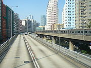
The first sections of road (Lung Cheung Road
Lung Cheung Road
Lung Cheung Road is part of Route 7 in Hong Kong, linking Kwun Tong Road at Ngau Chi Wan and Ching Cheung Road near Tai Wo Ping. It is a dual 3-lane carriageway for its entire length....
& Ching Cheung Road
Ching Cheung Road
Ching Cheung Road , part of the Route 7, is a dual carriageway in New Kowloon, Hong Kong linking Lung Cheung Road and Tai Po Road near Tai Wo Ping and Kwai Chung Road of Route 5 near Lai Chi Kok, varying between 2+2 lanes and 3+4 lanes for its length....
, built in 1961) were built as a 5 lane trunk road (then called Route 4; renamed when Route 7 on Hong Kong Island was renamed Route 4), it was expanded to the current 6 lane highway. The highway was completed in 1990 following the opening of the Tseung Kwan O Tunnel
Tseung Kwan O Tunnel
Tseung Kwan O Tunnel is a 900-metre tunnel beneath Ma Yau Tong in Hong Kong. Part of Route 7, it links Sau Mau Ping, Kwun Tong of East Kowloon and the new town of Tseung Kwan O , Sai Kung in New Territories...
.
Route 7 consists of three parts:
Route 7 begins in the east at Tseung Kwan O
Tseung Kwan O
Tseung Kwan O is a bay in Sai Kung District, New Territories, Hong Kong. In the northern tip of the bay lies the Tseung Kwan O Village....
and travels west into Kwun Tong
Kwun Tong
Kwun Tong is an area in Kwun Tong District, situated at the eastern part of the Kowloon Peninsula, and its boundary stretches from Lion Rock in the north to Lei Yue Mun in the south, and from the winding paths of Kowloon Peak in the east to the north coast of the former Kai Tak Airport runway in...
via the Tseung Kwan O Tunnel
Tseung Kwan O Tunnel
Tseung Kwan O Tunnel is a 900-metre tunnel beneath Ma Yau Tong in Hong Kong. Part of Route 7, it links Sau Mau Ping, Kwun Tong of East Kowloon and the new town of Tseung Kwan O , Sai Kung in New Territories...
. It passes under Sau Mau Ping Road and then exits off the freeway mainline onto Kwun Tong Road
Kwun Tong Road
Kwun Tong Road is a major road in Kwun Tong of New Kowloon in Hong Kong. It starts at the junction with Prince Edward Road East, Clear Water Bay Road and Lung Cheung Road in Ngau Chi Wan...
. The freeway mainline continues as the Kwun Tong Bypass
Kwun Tong Bypass
Kwun Tong Bypass is an elevated bypass expressway in Kwun Tong, Kowloon, Hong Kong with three lanes in each direction and a posted speed limit of 70-80 kilometres per hour. It comprises part of Route 2 and has links to Route 5 and Route 7....
(Route 2).
From Kwun Tong
Kwun Tong
Kwun Tong is an area in Kwun Tong District, situated at the eastern part of the Kowloon Peninsula, and its boundary stretches from Lion Rock in the north to Lei Yue Mun in the south, and from the winding paths of Kowloon Peak in the east to the north coast of the former Kai Tak Airport runway in...
, the route utilises Kwun Tong Road, turning north passing Kowloon Bay
Kowloon Bay
Kowloon Bay is a bay located at the east of the Kowloon Peninsula and north of Hong Kong Island in Hong Kong. It is the eastern portion of Victoria Harbour, between Hung Hom and Lei Yue Mun...
and splits with Route 5 at Kai Fuk Road and continues northward to Choi Hung, where it junctions with Prince Edward Road East & Clear Water Bay Road
Clear Water Bay Road
Clear Water Bay Road is a major road from a complex interchange in Ngau Chi Wan to a dead end in Clear Water Bay, Sai Kung. It also is a route to Sai Kung Town and Tseung Kwan O via Hang Hau Road and Hiram's Highway respectively...
and then the road turns west again and follows Lung Cheung Road passing through Diamond Hill
Diamond Hill
Diamond Hill is a hill in Kowloon, Hong Kong. The name also refers to the area on or adjacent to the hill. It is surrounded by Ngau Chi Wan, San Po Kong, Wong Tai Sin and Tsz Wan Shan. Its northeast is limited by the ridge. It is principally a residential district.-Etymology:Contrary to its name,...
, Wong Tai Sin
Wong Tai Sin
Wong Tai Sin is a Chinese deity popular in Hong Kong with the power of healing. His name literally translates to the "Great Immortal Wong". Wong Tai Sin is the divine form of the individual "Wong Cho Ping".-Legend:...
& Wang Tau Hom
Wang Tau Hom
Wang Tau Hom is an area in mid-north New Kowloon of Hong Kong. A public housing estate, Wang Tau Hom Estate, erects in the area.Usually, Wang Tau Hom is regarded as part of Lok Fu due to the nearby MTR station....
and then junctions the entrance of the Lion Rock Tunnel
Lion Rock Tunnel
The Lion Rock Tunnel, being the first tunnel in Hong Kong, is a twin-bored toll tunnel, connecting Sha Tin in the New Territories and New Kowloon near Kowloon Tong. It has two lanes in each direction, with toll booths located at the Sha Tin end. It is a vital component of Route 1.The Lion Rock...
and follows the foothills of northern Kowloon. At Tai Wo Ping, the route interchanges with Tai Po Road
Tai Po Road
Tai Po Road is the second longest road in Hong Kong . It spans from Sham Shui Po in Kowloon to Tai Po in the New Territories of Hong Kong. Initially, the road was named Frontier Road....
, continuing as Ching Cheung Road, bypassing Sham Shui Po
Sham Shui Po
Sham Shui Po, or Shamshuipo, is an area of Sham Shui Po District, Hong Kong, situated in the northwestern part of the Kowloon Peninsula, north of Tai Kok Tsui, east of Cheung Sha Wan and south of Shek Kip Mei. Sham Shui Po is known for its street market for electronic devices.-History:Sham Shui Po...
& Cheung Sha Wan
Cheung Sha Wan
Cheung Sha Wan is an area between Lai Chi Kok and Sham Shui Po in New Kowloon, Hong Kong. It is mainly residential to the north and south, with an industrial area in between. Administratively it is part of Sham Shui Po District. The Sham Shui Po District includes Mei Foo as well as Lai Chi...
before terminating at Kwai Chung
Kwai Chung
Kwai Chung is a town in the New Territories of Hong Kong. Together with Tsing Yi Island, it is part of the Kwai Tsing District of Hong Kong. Kwai Chung is the site of the container port. It is also part of Tsuen Wan New Town. In 2000, it had a population of 287,000...
and joins Route 5 (Hong Kong)
Route 5 (Hong Kong)
Route 5 is a route artery in Hong Kong from eastern to western Kowloon and New Kowloon, and ends in Tsuen Wan in the New Territories, linking Route 9....
.
The areas traversed by Route 7 include:
- Tseung Kwan OTseung Kwan OTseung Kwan O is a bay in Sai Kung District, New Territories, Hong Kong. In the northern tip of the bay lies the Tseung Kwan O Village....
- Tseung Kwan O TunnelTseung Kwan O TunnelTseung Kwan O Tunnel is a 900-metre tunnel beneath Ma Yau Tong in Hong Kong. Part of Route 7, it links Sau Mau Ping, Kwun Tong of East Kowloon and the new town of Tseung Kwan O , Sai Kung in New Territories...
- Kwun TongKwun TongKwun Tong is an area in Kwun Tong District, situated at the eastern part of the Kowloon Peninsula, and its boundary stretches from Lion Rock in the north to Lei Yue Mun in the south, and from the winding paths of Kowloon Peak in the east to the north coast of the former Kai Tak Airport runway in...
- Wong Tai SinWong Tai Sin, Hong KongWong Tai Sin is an area in Wong Tai Sin District, New Kowloon, Hong Kong. The area was named after the Wong Tai Sin Temple.Wong Tai Sin is surrounded by northeast Tsz Wan Shan, east Diamond Hill, south San Po Kong, south west Tung Tau and west Wang Tai Hom...
- Sham Shui PoSham Shui PoSham Shui Po, or Shamshuipo, is an area of Sham Shui Po District, Hong Kong, situated in the northwestern part of the Kowloon Peninsula, north of Tai Kok Tsui, east of Cheung Sha Wan and south of Shek Kip Mei. Sham Shui Po is known for its street market for electronic devices.-History:Sham Shui Po...
- Lai Chi KokLai Chi KokLai Chi Kok is a neighborhood in New Kowloon, Hong Kong, east of Kwai Chung and west of Cheung Sha Wan. Mei Foo Sun Chuen is the largest housing estate in the area. Administratively, it belongs to the Sham Shui Po District.-History:...
- Kwai ChungKwai ChungKwai Chung is a town in the New Territories of Hong Kong. Together with Tsing Yi Island, it is part of the Kwai Tsing District of Hong Kong. Kwai Chung is the site of the container port. It is also part of Tsuen Wan New Town. In 2000, it had a population of 287,000...
Route 7 intersects a number of other highways including:
- Route 1 (Hong Kong)Route 1 (Hong Kong)Route 1 in Hong Kong is a major artery that runs in a generally north-south direction from Aberdeen to Sha Tin.The route begins at Aberdeen Praya Road in southern Hong Kong Island, which then turns into Wong Chuk Hang Road...
- Route 2 (Hong Kong)Route 2 (Hong Kong)Route 2 of Hong Kong runs from Quarry Bay of Hong Kong Island to Ma Liu Shui of the New Territories, formerly known as route 6, and renamed as route 2 in 2004 under the route numbering scheme proposed in the same year....
- Route 3 (Hong Kong)Route 3 (Hong Kong)Route 3 is a series of expressways in Hong Kong from Sai Ying Pun on the Hong Kong Island to Yuen Long in the New Territories, via Yau Ma Tei, Kwai Chung and Tsing Yi Island.From south to north, Route 3 can be divided into four parts...
- Route 5 (Hong Kong)Route 5 (Hong Kong)Route 5 is a route artery in Hong Kong from eastern to western Kowloon and New Kowloon, and ends in Tsuen Wan in the New Territories, linking Route 9....
Observed roads and exits
| Westbound towards Kwai Chung Kwai Chung Kwai Chung is a town in the New Territories of Hong Kong. Together with Tsing Yi Island, it is part of the Kwai Tsing District of Hong Kong. Kwai Chung is the site of the container port. It is also part of Tsuen Wan New Town. In 2000, it had a population of 287,000... |
Eastbound towards Tseung Kwan O Tseung Kwan O Tseung Kwan O is a bay in Sai Kung District, New Territories, Hong Kong. In the northern tip of the bay lies the Tseung Kwan O Village.... |
|||
| Exit | Destination | Exit | Destination | |
| Tseung Kwan O | ||||
| Tseung Kwan O Tunnel Road | ||||
| 1 | Po Yap Road/Chiu Shun Road Sai Kung and Tseung Kwan O Town Centre |
1 | Po Yap Road/Chiu Shun Road Sai Kung and Tseung Kwan O Town Centre |
|
| 2 | Po Shun Road Tseung Kwan O Town Centre and Tiu Keng Leng Tiu Keng Leng Tiu Keng Leng is an area of Hong Kong in the Sai Kung District adjacent to Tseung Kwan O .-History:... |
2 | Po Shun Road Tseung Kwan O Town Centre and Tiu Keng Leng Tiu Keng Leng Tiu Keng Leng is an area of Hong Kong in the Sai Kung District adjacent to Tseung Kwan O .-History:... |
|
| 2A | Po Shun RoadPo Lam Po Lam Po Lam is an area in the northern part of Tseung Kwan O, New Territories, Hong Kong. The name of the area came from the first road in Tseung Kwan O, the Po Lam Road, built in 1950s. An MTR station with the same name is located there.... , Hang Hau Hang Hau Hang Hau is a residential area in Hong Kong. It is located at the eastern edge of the Tseung Kwan O New Town. Most of the land was reclaimed from Ap Chai Wan .- History :... and Sai Kung |
|||
| Tseung Kwan O Tunnel Tseung Kwan O Tunnel Tseung Kwan O Tunnel is a 900-metre tunnel beneath Ma Yau Tong in Hong Kong. Part of Route 7, it links Sau Mau Ping, Kwun Tong of East Kowloon and the new town of Tseung Kwan O , Sai Kung in New Territories... |
||||
| Tseung Kwan O Road | ||||
| 3A | Sau Mau Ping Road/ Lin Tak Road Sau Mau Ping Sau Mau Ping Sau Mau Ping is an area in eastern New Kowloon, Hong Kong.Its Chinese name was formerly So Mau Ping , but this was often mis-rendered So Mo Ping , meaning a place to 'visit one's ancestors'. In fact, during World War II, much of the area was used as a cemetery... and Lam Tin Lam Tin Lam Tin is an area in the Kwun Tong District in southeastern New Kowloon, Hong Kong. Lam Tin is primarily a residential area, though it also hosts a major transport interchange and the location of several renowned shopping attractions. Lam Tin was once a large field in the vicinity of Kowloon Bay.... |
|||
| 3B | Kai Tin Road Lam Tin Lam Tin Lam Tin is an area in the Kwun Tong District in southeastern New Kowloon, Hong Kong. Lam Tin is primarily a residential area, though it also hosts a major transport interchange and the location of several renowned shopping attractions. Lam Tin was once a large field in the vicinity of Kowloon Bay.... |
|||
| 4 | Lei Yue Mun Road Route 2 Route 2 (Hong Kong) Route 2 of Hong Kong runs from Quarry Bay of Hong Kong Island to Ma Liu Shui of the New Territories, formerly known as route 6, and renamed as route 2 in 2004 under the route numbering scheme proposed in the same year.... southbound to Quarry Bay Quarry Bay Quarry Bay is an area beneath Mount Parker in the Eastern District of Hong Kong Island, in Hong Kong. The western portion of the area was also formerly known as Lai Chi... |
4 | Route 2 southbound to Quarry Bay | |
| Kwun Tong Road | ||||
| 4A | Kwun Tong Bypass Route 2 northbound to Ma Liu Shui Ma Liu Shui Ma Liu Shui or originally Ma Niu Shui is an area in Sha Tin District, in the New Territories, Hong Kong.The area faces Tide Cove and Tolo Harbour... |
|||
| 4B | Cha Kwo Ling Road | |||
| 5 | Hip Wo Street/Hoi Yuen Road Sau Mau Ping and Kwun Tong Kwun Tong Kwun Tong is an area in Kwun Tong District, situated at the eastern part of the Kowloon Peninsula, and its boundary stretches from Lion Rock in the north to Lei Yue Mun in the south, and from the winding paths of Kowloon Peak in the east to the north coast of the former Kai Tak Airport runway in... Industrial Area |
5 | Hip Wo Street/Hoi Yuen Road Sau Mau Ping and Kwun Tong Industrial Area |
|
| 5A | Hong Ning Road | |||
| 5C | Lai Yip Street/Elegance Road Kowloon Bay Kowloon Bay Kowloon Bay is a bay located at the east of the Kowloon Peninsula and north of Hong Kong Island in Hong Kong. It is the eastern portion of Victoria Harbour, between Hung Hom and Lei Yue Mun... |
|||
| 5D | Kai Fuk Road Route 5 Route 5 (Hong Kong) Route 5 is a route artery in Hong Kong from eastern to western Kowloon and New Kowloon, and ends in Tsuen Wan in the New Territories, linking Route 9.... westbound towards Tsuen Wan Tsuen Wan Tsuen Wan is a bay in the Kowloon area of Hong Kong, opposite to Tsing Yi Island across Rambler Channel. The market town of Tsuen Wan emerged for the surrounding villages and fleets of fishing boats in the area. The town is around the present-day Tsuen Wan Station of the MTR... |
|||
| 6A | Ngau Tau Kok Road Ngau Tau Kok Ngau Tau Kok Ngau Tau Kok is an area of Kowloon, Hong Kong, located at the northern part of Kwun Tong District, next to Kowloon Bay. It covers Jordan Valley, Ngau Tau Kok and Upper Kwun Tong town centre. The population of Ngau Tau Kok exceeds 210,000... and Kwun Tong |
|||
| 6B | Ting Fu Street | |||
| 6C | Telford Garden | |||
| 6D | Ngau Tau Kok Road | |||
| 6E | Ngau Tau Kok 5th Street | |||
| 6F | Ngau Tau Kok | |||
| 6G | Jordan Valley and Sau Mau Ping | |||
| 7A | Kowloon City Kowloon City Kowloon City is an area in Kowloon, Hong Kong. It is named after the Kowloon Walled City, and is administratively part of Kowloon City District.... |
|||
| Wai Yip St | 7B | Kowloon Bay | ||
| 8 | New Clear Water Bay Road Mong Kok Mong Kok Mong Kok , less often known as Argyle , is an area in the Yau Tsim Mong District on Kowloon Peninsula, Hong Kong... and Sai Kung |
8 | Sai Kung | |
| Lung Cheung Road | ||||
| 9 | Route 2 northbound to Ma Liu Shui | 9 | Route 2 northbound to Ma Liu Shui | |
| 10 | San Po Kong San Po Kong San Po Kong is an area in New Kowloon in Hong Kong. South of Wong Tai Sin and Diamond Hill, and north of the former Kai Tak International Airport, the area is bounded by Choi Hung Road and Prince Edward Road. San Po Kong is largely industrial and partly residential. Administratively, it belongs... |
10 | San Po Kong | |
| 10A | Tsz Wan Shan | |||
| 10B | Wong Tai Sin | |||
| 11 | Kowloon City | 11 | Kowloon City | |
| 11A | Kowloon City | |||
| 12 | Route 1 Route 1 (Hong Kong) Route 1 in Hong Kong is a major artery that runs in a generally north-south direction from Aberdeen to Sha Tin.The route begins at Aberdeen Praya Road in southern Hong Kong Island, which then turns into Wong Chuk Hang Road... northbound towards Fo Tan Fo Tan Fo Tan is a suburb of Sha Tin District, Hong Kong. It was developed as a light industrial area, but this activity has declined markedly in recent years. There are residential areas to the east, alongside the MTR line, and in the foothills to the west.... |
12 | Route 1 northbound towards Fo Tan | |
| 13 | Viewing Terrace | 13 | Fung King Court | |
| 13A | Sham Shui Po Sham Shui Po Sham Shui Po, or Shamshuipo, is an area of Sham Shui Po District, Hong Kong, situated in the northwestern part of the Kowloon Peninsula, north of Tai Kok Tsui, east of Cheung Sha Wan and south of Shek Kip Mei. Sham Shui Po is known for its street market for electronic devices.-History:Sham Shui Po... |
|||
| 13B | Shek Kip Mei Shek Kip Mei Shek Kip Mei, originally known as Kap Shek Mi, is an area in New Kowloon, the North Eastern Kowloon Peninsula of Hong Kong.-History:A major fire on 25 December 1953, destroyed the Shek Kip Mei shantytown of immigrants from Mainland China that had fled to Hong Kong, leaving 53,000 people... |
|||
| 13C | Sham Shui Po | |||
| 13D | Shatin (via Tai Po Road) | |||
| Ching Cheung Road | ||||
| 14A | Caritas Hospital | |||
| 14B | Lai Chi Kok Lai Chi Kok Lai Chi Kok is a neighborhood in New Kowloon, Hong Kong, east of Kwai Chung and west of Cheung Sha Wan. Mei Foo Sun Chuen is the largest housing estate in the area. Administratively, it belongs to the Sham Shui Po District.-History:... |
|||
| 14C | Tsuen Wan Tsuen Wan Tsuen Wan is a bay in the Kowloon area of Hong Kong, opposite to Tsing Yi Island across Rambler Channel. The market town of Tsuen Wan emerged for the surrounding villages and fleets of fishing boats in the area. The town is around the present-day Tsuen Wan Station of the MTR... |
|||
| 14E | Route 3 Route 3 (Hong Kong) Route 3 is a series of expressways in Hong Kong from Sai Ying Pun on the Hong Kong Island to Yuen Long in the New Territories, via Yau Ma Tei, Kwai Chung and Tsing Yi Island.From south to north, Route 3 can be divided into four parts... northbound towards Yuen Long Yuen Long Yuen Long , formerly Un Long, is an area and town located in the northwest of Hong Kong, on the Yuen Long Plain. To its west lie Hung Shui Kiu and Ha Tsuen, to the south Shap Pat Heung and Tai Tong, to the east Au Tau and Kam Tin, and to the north Nam Sang Wai.-Name:The Cantonese name Yuen Long 元朗... |
|||
| Kwai Chung (intersection with Route 5 Route 5 (Hong Kong) Route 5 is a route artery in Hong Kong from eastern to western Kowloon and New Kowloon, and ends in Tsuen Wan in the New Territories, linking Route 9.... ) |
||||