
Beaufort Island
Encyclopedia
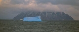
Beaufort Island is an island
in Antarctica's Ross Sea
. It is the northernmost feature of the Ross Archipelago
, lying 21 kilometres (13 mi) north of Cape Bird
, Ross Island
. It is approximately 18.4 square kilometres (7 sq mi) in area. It was first charted by James Clark Ross
in 1841. Ross named the island for Sir Francis Beaufort
, hydrographer
to the British Royal Navy
.
. It is semi circular in shape. The highest point in the island is Paton Peak, at 771 m (2,530 ft). The island has varied terrain
and habitat
s. Much of the western side of the island is covered by moderately sloping ice fields with ice cliffs about 20 m (66 ft) high on the coast. The east and south sides of the island are mostly free of ice, with steep inaccessible cliffs that rise straight from the sea. Here the ice-free ground has a gentle slope and has ponds in summer and small meltwater streams that drain to the coast.
than other locations in the Ross Sea. Although some studies have been conducted on the island, it has not been comprehensively studied.
There is a small colony of breeding Emperor Penguin
s on nearshore sea ice at the north end of the island. There is a large Adélie Penguin
colony on a raised beach
called Cadwalader Beach at the south-western end of the island. The island also has several breeding colonies of South Polar Skua
.
The island has an extensive area of vegetation on a moraine
bench 5–7 m (16.4–23 ft) above the beach at the north end of the island. The moraine bench is up to 50 m (164 ft) wide. The vegetation is dominated by the moss
species Bryum argenteum. It is the most extensive and continuous area of mosses known of in the McMurdo Sound
region. There is also a diverse community of algae
. This location is one of the most southerly locations where red snow algae (Chlamydomonas sp., Chloromonas sp., and Chlamydomonas nivalis) are found. This location is favourable for vegetation growth because of warm summer temperatures. Its northerly aspect and the shelter provided by high ice cliffs protect against southerly winds. Water is supplied from the ice-cliffs and snow banks.
Island
An island or isle is any piece of sub-continental land that is surrounded by water. Very small islands such as emergent land features on atolls can be called islets, cays or keys. An island in a river or lake may be called an eyot , or holm...
in Antarctica's Ross Sea
Ross Sea
The Ross Sea is a deep bay of the Southern Ocean in Antarctica between Victoria Land and Marie Byrd Land.-Description:The Ross Sea was discovered by James Ross in 1841. In the west of the Ross Sea is Ross Island with the Mt. Erebus volcano, in the east Roosevelt Island. The southern part is covered...
. It is the northernmost feature of the Ross Archipelago
Ross Archipelago
Ross Archipelago is a convenient name for that group of islands which, together with the ice shelf between them, forms the eastern and southern boundaries of McMurdo Sound. The most northerly is Beaufort Island, then comes Ross Island, the Dellbridge Islands, and Black Island and White Island...
, lying 21 kilometres (13 mi) north of Cape Bird
Cape Bird
Cape Bird is a cape which marks the north extremity of Ross Island. Discovered in 1841 by a British expedition under Ross, and named by him for Lieutenant Edward J. Bird of the ship Erebus....
, Ross Island
Ross Island
Ross Island is an island formed by four volcanoes in the Ross Sea near the continent of Antarctica, off the coast of Victoria Land in McMurdo Sound.-Geography:...
. It is approximately 18.4 square kilometres (7 sq mi) in area. It was first charted by James Clark Ross
James Clark Ross
Sir James Clark Ross , was a British naval officer and explorer. He explored the Arctic with his uncle Sir John Ross and Sir William Parry, and later led his own expedition to Antarctica.-Arctic explorer:...
in 1841. Ross named the island for Sir Francis Beaufort
Francis Beaufort
Rear-Admiral Sir Francis Beaufort, FRS, FRGS was an Irish hydrographer and officer in Britain's Royal Navy...
, hydrographer
Hydrography
Hydrography is the measurement of the depths, the tides and currents of a body of water and establishment of the sea, river or lake bed topography and morphology. Normally and historically for the purpose of charting a body of water for the safe navigation of shipping...
to the British Royal Navy
Royal Navy
The Royal Navy is the naval warfare service branch of the British Armed Forces. Founded in the 16th century, it is the oldest service branch and is known as the Senior Service...
.
Geography
Beaufort Island was created by volcanic activity and is made up of basaltBasalt
Basalt is a common extrusive volcanic rock. It is usually grey to black and fine-grained due to rapid cooling of lava at the surface of a planet. It may be porphyritic containing larger crystals in a fine matrix, or vesicular, or frothy scoria. Unweathered basalt is black or grey...
. It is semi circular in shape. The highest point in the island is Paton Peak, at 771 m (2,530 ft). The island has varied terrain
Terrain
Terrain, or land relief, is the vertical and horizontal dimension of land surface. When relief is described underwater, the term bathymetry is used...
and habitat
Habitat
* Habitat , a place where a species lives and grows*Human habitat, a place where humans live, work or play** Space habitat, a space station intended as a permanent settlement...
s. Much of the western side of the island is covered by moderately sloping ice fields with ice cliffs about 20 m (66 ft) high on the coast. The east and south sides of the island are mostly free of ice, with steep inaccessible cliffs that rise straight from the sea. Here the ice-free ground has a gentle slope and has ponds in summer and small meltwater streams that drain to the coast.
Ecology
Beaufort Island is designated an Antarctic Specially Protected Area in order to preserve its natural ecological system and to protect its varied and numerous bird species. The island is isolated and difficult to access and is visited infrequently by people. It is largely undisturbed by direct human activity, and there have been fewer opportunities for the introduction of exotic speciesIntroduced species
An introduced species — or neozoon, alien, exotic, non-indigenous, or non-native species, or simply an introduction, is a species living outside its indigenous or native distributional range, and has arrived in an ecosystem or plant community by human activity, either deliberate or accidental...
than other locations in the Ross Sea. Although some studies have been conducted on the island, it has not been comprehensively studied.
There is a small colony of breeding Emperor Penguin
Emperor Penguin
The Emperor Penguin is the tallest and heaviest of all living penguin species and is endemic to Antarctica. The male and female are similar in plumage and size, reaching in height and weighing anywhere from . The dorsal side and head are black and sharply delineated from the white belly,...
s on nearshore sea ice at the north end of the island. There is a large Adélie Penguin
Adelie Penguin
The Adélie Penguin, Pygoscelis adeliae, is a species of penguin common along the entire Antarctic coast. They are among the most southerly distributed of all seabirds, as are the Emperor Penguin, the South Polar Skua, the Wilson's Storm Petrel, the Snow Petrel, and the Antarctic Petrel...
colony on a raised beach
Raised beach
A raised beach, marine terrace, or perched coastline is an emergent coastal landform. Raised beaches and marine terraces are beaches or wave-cut platforms raised above the shore line by a relative fall in the sea level ....
called Cadwalader Beach at the south-western end of the island. The island also has several breeding colonies of South Polar Skua
South Polar Skua
The South Polar Skua, Stercorarius maccormicki, is a large seabird in the skua family Stercorariidae. An older name for the bird is MacCormick’s Skua, after explorer and naval surgeon Robert McCormick, who first collected the type specimen...
.
The island has an extensive area of vegetation on a moraine
Moraine
A moraine is any glacially formed accumulation of unconsolidated glacial debris which can occur in currently glaciated and formerly glaciated regions, such as those areas acted upon by a past glacial maximum. This debris may have been plucked off a valley floor as a glacier advanced or it may have...
bench 5–7 m (16.4–23 ft) above the beach at the north end of the island. The moraine bench is up to 50 m (164 ft) wide. The vegetation is dominated by the moss
Moss
Mosses are small, soft plants that are typically 1–10 cm tall, though some species are much larger. They commonly grow close together in clumps or mats in damp or shady locations. They do not have flowers or seeds, and their simple leaves cover the thin wiry stems...
species Bryum argenteum. It is the most extensive and continuous area of mosses known of in the McMurdo Sound
McMurdo Sound
The ice-clogged waters of Antarctica's McMurdo Sound extend about 55 km long and wide. The sound opens into the Ross Sea to the north. The Royal Society Range rises from sea level to 13,205 feet on the western shoreline. The nearby McMurdo Ice Shelf scribes McMurdo Sound's southern boundary...
region. There is also a diverse community of algae
Algae
Algae are a large and diverse group of simple, typically autotrophic organisms, ranging from unicellular to multicellular forms, such as the giant kelps that grow to 65 meters in length. They are photosynthetic like plants, and "simple" because their tissues are not organized into the many...
. This location is one of the most southerly locations where red snow algae (Chlamydomonas sp., Chloromonas sp., and Chlamydomonas nivalis) are found. This location is favourable for vegetation growth because of warm summer temperatures. Its northerly aspect and the shelter provided by high ice cliffs protect against southerly winds. Water is supplied from the ice-cliffs and snow banks.
See also
- Composite Antarctic Gazetteer
- List of Antarctic and sub-Antarctic islands
- List of Antarctic islands south of 60° S
- SCARScientific Committee on Antarctic ResearchThe Scientific Committee on Antarctic Research is an interdisciplinary body of the International Council for Science . It was established in February 1958 to continue the international coordination of Antarctic scientific activities that had begun during the International Geophysical Year of 1957-58...
- Territorial claims in Antarctica