

Rewa District
Encyclopedia
Districts of Madhya Pradesh
Following is the list of districts in the Indian state Madhya Pradesh. It has 50 districts grouped into ten divisions.Bhopal Division* Bhopal District* Raisen District* Rajgarh District* Sehore District* Vidisha DistrictChambal Division...
of Madhya Pradesh
Madhya Pradesh
Madhya Pradesh , often called the Heart of India, is a state in central India. Its capital is Bhopal and Indore is the largest city....
state
States and territories of India
India is a federal union of states comprising twenty-eight states and seven union territories. The states and territories are further subdivided into districts and so on.-List of states and territories:...
in central India
India
India , officially the Republic of India , is a country in South Asia. It is the seventh-largest country by geographical area, the second-most populous country with over 1.2 billion people, and the most populous democracy in the world...
. The city Rewa is the district headquarters. Rewa is also known as land of white tigers.
Geography
The Huzur, Sirmour and Mauganj tahsils lie between the Kaimur on the south and the Binjh pahar on the north and form what is known as Rewa plateau or uprihar. To the north lies the Teonther tahsils whish is quite different with regard to its physical and other features from the plateau tahsils. Rewa is basically a plateau and from the south to the north its height decreases. In the south the height of Kaimur Rang is more than 450 meters, whereas the height of alluvral plain of Teonthor is just 100 meters. In the district, dissected hills, ravines, plain, plateau, scarp, water-fall and alluvial plain can be seen. The rain-water of the district is flown out by the two assisting rivers of the Ganges, the Tons or TamasTamsa River
The Tamsa River is a tributary of the Ganges flowing through the Indian states of Madhya Pradesh and Uttar Pradesh.-Course:...
and the Son
Son River
Son River of central India is the largest of the Ganges' southern tributaries. A British 1850s diary shows that the river was written in English as Soane.-Course:...
. Bichiya River flows through the heart of Rewa city.
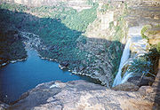
Significant waterfalls on the Tamsa or Tons
Tamsa River
The Tamsa River is a tributary of the Ganges flowing through the Indian states of Madhya Pradesh and Uttar Pradesh.-Course:...
and its tributaries, as they come down from the Rewa Plateau
Rewa Plateau
The Rewa Plateau covers a portion of Rewa district in the Indian state of Madhya Pradesh.The Rewa Plateau lies between the Kaimur Range in the south and Vindhya Range or Binj Pahar in the north. To the north of the Binj Pahar are the alluvial plains known as Uprihar. The plateau covers the Huzur,...
, are: Chachai Falls (127m) on the Bihad River, a tributary of the Tamsa, the Keoti Falls
Keoti Falls
Keoti Falls is in Rewa district in the Indian state of Madhya Pradesh. It is the 24th highest waterfall in India.-The Falls:...
(98m) on the Mahana River, a tributary of the Tamsa, Odda Falls
Bahuti Falls
The Bahuti Falls is a waterfall in Rewa district in the Indian state of Madhya Pradesh.-The falls:Bahuti Falls is on the Odda River as it rushes down the edge of the Rewa Plateau to join the Bihad River, which is a tributary of Tamsa or Tons River. It is near Chachai Falls.It has a height of .The...
(145m) on the Odda River, a tributary of the Belah River, which is itself a tributary of the Tamsa, and Purwa Falls
Purwa Falls
The Purwa Falls is a waterfall in Rewa district in the Indian state of Madhya Pradesh.-The falls:The Tons River while descending through the Rewa Plateau and draining northwards makes a vertical falls of known as the Purwa Falls....
(70m) on the Tamsa or Tons.
Rewa lies between 240 18’ and 250 12’ north latitudes and 810 2’ and 820 18’.
The district is bounded on the north by Uttar Pradesh
Uttar Pradesh
Uttar Pradesh abbreviation U.P. , is a state located in the northern part of India. With a population of over 200 million people, it is India's most populous state, as well as the world's most populous sub-national entity...
, on the east and southeast by Sidhi
Sidhi District
Sidhi district is one of the districts of Madhya Pradesh state of India. The town of Sidhi is the district headquarters. The district is part of Rewa Division.-History:...
, on the south by Shahdol
Shahdol District
Shahdol District is a district of Madhya Pradesh state in central India. With a total area of 5,671 square kilometers and a population of 908,148. Shahdol is an important district of Madhya Pradesh. The town of Shahdol is the district headquarters. The district is also a Division...
, and on the west by Satna
Satna District
Satna District , was formed in 1948, is a district of Madhya Pradesh state in central India. The town of Satna is the district headquarters. The district has an area of 7,502 km², and a population of 1,868,648 , 20.63% of which was urban...
. It is part of Rewa Division
Rewa Division
Rewa Division is an administrative geographical unit of Madhya Pradesh state of India situated in the North East part of state bordering with Uttar Pradesh, Chattisgarh and Bundelkhand part of Madhya Pradesh. Rewa is the administrative headquarters of the division...
. It has an area of 6,240 km2.
Divisions
Rewa district is divided in to 9 tehsilTehsil
A Tehsil or Tahsil/Tahasil , also known as Taluk and Mandal, is an administrative division of some country/countries of South Asia....
s named mangava, Naigarhi, Sirmaur, Jawa, Teonthar, Hanumana, Hujur, Raipur Karchulian and Mauganj, where as Rewa city lies in Hujur Tehsil.
Demographics
According to the 2011 census2011 census of India
The 15th Indian National census was conducted in two phases, houselisting and population enumeration. Houselisting phase began on April 1, 2010 and involved collection of information about all buildings...
Rewa District has a population
Demographics of India
The demographics of India are inclusive of the second most populous country in the world, with over 1.21 billion people , more than a sixth of the world's population. Already containing 17.5% of the world's population, India is projected to be the world's most populous country by 2025, surpassing...
of 2,363,744, roughly equal to the nation of Latvia
Latvia
Latvia , officially the Republic of Latvia , is a country in the Baltic region of Northern Europe. It is bordered to the north by Estonia , to the south by Lithuania , to the east by the Russian Federation , to the southeast by Belarus and shares maritime borders to the west with Sweden...
or the US state of New Mexico
New Mexico
New Mexico is a state located in the southwest and western regions of the United States. New Mexico is also usually considered one of the Mountain States. With a population density of 16 per square mile, New Mexico is the sixth-most sparsely inhabited U.S...
. This gives it a ranking of 191st in India (out of a total of 640
Districts of India
A district is an administrative division of an Indian state or territory. Districts are further subdivided, in some cases into Sub-Divisions, and otherwise directly into tehsils or talukas.District officials include:...
). The district has a population density of 374 PD/sqkm . Its population growth rate
Family planning in India
Family planning in India is based on efforts largely sponsored by the Indian government. In the 1965-2009 period, contraceptive usage has more than tripled and the fertility rate has more than halved , but the national fertility rate is still high enough to cause long-term population growth...
over the decade 2001-2011 was 19.79 %. Rewa has a sex ratio
Sex ratio
Sex ratio is the ratio of males to females in a population. The primary sex ratio is the ratio at the time of conception, secondary sex ratio is the ratio at time of birth, and tertiary sex ratio is the ratio of mature organisms....
of 930 females
Women in India
The status of women in India has been subject to many great changes over the past few millennia. From equal status with men in ancient times through the low points of the medieval period, to the promotion of equal rights by many reformers, the history of women in India has been eventful...
for every 1000 males, and a literacy rate
Literacy in India
Literacy in India is key for socio-economic progress, and the Indian literacy rate grew to 74.04% in 2011 from 12% at the end of British rule in 1947. Although this was a greater than sixfold improvement, the level is well below the world average literacy rate of 84%, and India currently has the...
of 73.42 %.
Languages
Languages spoken include AgariyaAgariya language
The Agariya language is spoken by the Agariya people, especially in Madhya Pradesh in India. It is a Munda language....
, an Austro-Asiatic tongue with approximately 72 000 speakers; Bagheli, which has a lexical similarity
Lexical similarity
In linguistics, lexical similarity is a measure of the degree to which the word sets of two given languages are similar. A lexical similarity of 1 would mean a total overlap between vocabularies, whereas 0 means there are no common words....
of 72-91% with Hindi
Hindi
Standard Hindi, or more precisely Modern Standard Hindi, also known as Manak Hindi , High Hindi, Nagari Hindi, and Literary Hindi, is a standardized and sanskritized register of the Hindustani language derived from the Khariboli dialect of Delhi...
(compared to 60% for German and English) and is spoken by about 7 800 000 people in Bagelkhand
Bagelkhand
Bagelkhand or Baghelkhand, is a region in central India, in northeastern Madhya Pradesh state. It includes the Madhya Pradesh districts of Anuppur, Rewa, Satna, Shadol, Sidhi, and Umaria....
; and Bharia, a Dravidian
Dravidian languages
The Dravidian language family includes approximately 85 genetically related languages, spoken by about 217 million people. They are mainly spoken in southern India and parts of eastern and central India as well as in northeastern Sri Lanka, Pakistan, Nepal, Bangladesh, Afghanistan, Iran, and...
language spoken by at least 200 000 members of the Bharia
Bharia
Bharia is one of tribes of Madhya Pradesh in India.The Bharias live in Patalkot, which is completely isolated valley some 400 metres below Tamia in Chhindwara district of Madhya Pradesh.This valley is the source of Dudhi River...
tribe and written in the Devanagari script.
Tourism
- Deorkothar - It is known for its Buddhist stupas. The Deur Kothar stupa may have been established by the Maurya king Asoka in the 3rd century BCE. In the ancient times, the site was located on the DakshinapathaDakshinapathaAncient Buddhist and Hindu texts use the term Dakshinapatha as a name for both the southern high road of the Indian subcontinent, and for the region lying south of Majjhimdesa or middle India. It is derived from the two Sanskrit roots dakshina for south, and patha for road.The first reference to...
(Southern Trade Route) running east-west from PatliputraPatliputraPāṭaliputra , modern-day Patna, was a city in ancient India, originally built by Ajatashatru in 490 BC as a small fort near the River Ganges, and later the capital of the ancient Mahājanapadas kingdom of Magadha....
(Patna) to Pratishthana in MaharashtraMaharashtraMaharashtra is a state located in India. It is the second most populous after Uttar Pradesh and third largest state by area in India...
through Central India. working non. govt. org. matri-prakriti in fevour of environment,tourism,wildlife and tiger project office cont- 9755085468
Fauna
The first white tiger to be captured was not, as is often claimed, the famed Mohan.In December 1915, still a full thirty-six years prior to the capture of Mohan, Maharajah Gulab Singh of
Rewa caught a white cub. At the time of capture it was approximately two-years-old and lived in captivity
at the Maharajah's summer palace for another five years. The tiger was then stuffed and sent as a gift to
King George V as a sign of India's loyalty to the crown. To this day white tigers are still kept at the
Maharajah's summer palace which is located at Govindgarh.
In May 1951, Maharajah Shri Martand Singh was hunting in the jungles of Bandhavgarh. On 25 May a report
came that a tigress had been sighted with four cubs, one of which was white. The tigress was shot and this
was followed by two of her four cubs. More by luck than planning the white cub escaped. Rules of the time
allowed the shooting of a tigress with cubs and this was very common. The cub was captured and placed in
Maharajah's 150-roomed palace in a large open courtyard. On the 30th May, only three days after its capture,
the white cub escaped and a long hunt was organised to try and recover it. The white cub was reintroduced to a repaired courtyard where he was to live for the remainder of his life. This tiger was the famed Mohan.
Economy
Since this is a limestone belt and coal is found in the nearby districts of Shahdol, Umaria, Sidhi and Singrauli, various cement factories are nearby including in Naubasta, Bela (Satna district) and Bhagwar (Sidhi district) and the Jaypee Group has made a township known as Jaypee Nagar in Rewa.Asia's biggest cement factory Prism cement (prev. Rasi Cement) produces near Rewa at Satna district. Various Birla Group Companies like Vindhya Tele Links, Birla Ericson Ltd are also there.
In 2006 the Ministry of Panchayati Raj
Ministry of Panchayati Raj
The Ministry of Panchayati Raj is a branch of the Government of India looking after the ongoing process of decentralization and local governance in the States....
named Rewa one of the country's 250 most backward districts
Poverty in India
Poverty is widespread in India, with the nation estimated to have a third of the world's poor. According to a 2005 World Bank estimate, 41.6% of the total Indian population falls below the international poverty line of 1.25 a day...
(out of a total of 640
Districts of India
A district is an administrative division of an Indian state or territory. Districts are further subdivided, in some cases into Sub-Divisions, and otherwise directly into tehsils or talukas.District officials include:...
). It is one of the 24 districts in Madhya Pradesh currently receiving funds from the Backward Regions Grant Fund Programme (BRGF).
Transport
Railways: Rewa is connected to Satna through 50 km Rewa Satna Rail Line. Satna falls on Mumbai Howrah main line via Allahabad.Road: Rewa falls in India's longest Highway NH 7 Varanasi to Kanya Kumari Via Mirzapur, Katni, Jabalpur, Nagpur, Hyderabad, Bangalore. NH 27 To Allahabad, NH 75 From Ranchi To Gwaliar pass through Rewa.
Air: Nearest Airports is Khajuraho . Rewa has also got Air Strip at Churhat.
External links
- Rewa District web site
- Official website of Maharaja, Rewa (M.P.)
- Official website of Vindhya Group Technologies Pvt. Ltd., Rewa (M.P.)
- Genealogy of the ruling chiefs of Rewa
- RewaCityOnline, All Important Information about Rewa City
- Another Government website on Rewa
- Rewa District Government Contacts
- Rewa road map
- Rewa district map
- REWA ,The Baghel Dynasty,GENEALOGY
- Official website of Kidzworld School Rewa(M.P.)
- Official website of Hotel Jeet Residency Rewa, Rewa (M.P.)