
Quinnipiac Trail
Encyclopedia
The Quinnipiac Trail is a 24 miles (38.6 km) Blue-Blazed
hiking
trail
in New Haven County
, Connecticut
. It is the product of the evolution and growth of the first 10.6 miles (17.1 km) trail designated in Connecticut's Blue-Blazed Hiking Trail system
, with its light-blue rectangular vertical paint
ed blaze
s .
and the east side of the Wilbur Cross Parkway
through the entire length of the (undeveloped) Quinnipiac River State Park in North Haven
.
Turning mostly westward, away from the river, at the Toelles Rd. bridge at Hartford Turnpike
in North Haven, the Quinnipiac Trail traverses virtually the length of the Sleeping Giant State Park (5.1 miles east/west).
Just northwest of the "chest", an eight-mile (13 km) spur of the trail leads NNW, exiting the Park, crossing the Cheshire town line, continues north past Route 42, and after a steep hike overlooking the dramatic chasms of Roaring Brook Falls near the Prospect border, ends near Connecticut Route 68 on Chatfield Road.
campus and beyond to Long Island Sound
. The trail descends on relatively on an exposed slope along an abandoned quarry to the Mill River, west along Mt. Carmel Ave. in Hamden
, intersecting with both Whitney Avenue (Route 10), and the Farmington Canal
Greenway.
Between Whitney Avenue westward to Shepard Avenue (1.3 miles), the trail ascends Rocky Top, site of the Quinnipiac University hockey/basketball arena, the TD Bank Sports Center, opened in January, 2007 (also accessible by vehicle from Sherman Avenue). Since the clearing of surrounding land in 2007, the pinnacle of this 234 acre (0.94696524 km²), future-campus site rises well above the stadium structures, affording 360 degree views.
To the northeast, the distinctive Metacomet Ridge
is visible in Meriden
, 14.4 miles (23.2 km) from this point. To the ENE is a view of the traprock
quarry on the west-facing side (or "top") of the Sleeping Giant's head. To the east lies the original Quinnipiac University campus, with its signature white steeple.
Due south is the familiar landmark of East Rock
(6.1 miles), once a sacred site of the native Quinnipiac tribe, called "Rotenburg", by Dutch explorers in the early 17th century, for its red, rocky cliffs. Atop East Rock stands the Civil War
Soldiers and Sailors Monument
with its tall, thin column of the Angel of Victory, refurbished in 2006. The New Haven
skyline is silhouetted against its shimmering harbor on the Sound. Beyond, (31 miles) across the Sound lie the distant dunes of North Shore Beach in Long Island
.
To the south-southwest can be seen the undulating forests of West Rock Ridge State Park
, site of the Regicides Trail
. At its southwest extremity, the QT connects with the Regicides Trail, along the West Rock Ridge. A cell tower marks the approximate location of Judges' Cave.
(CFPA) provides commemorative patches as recognition to hikers completing the entire length of one of the three original Blue-Blazed trails in Connecticut (Quinnipiac, Metacomet and Mattabesett). The Quinnipiac Trail patch can be obtained for a small fee ($1) after the hiking the entire trail is completed by contacting the Connecticut Forest and Park Association
.
The Sleeping Giant Park Association (SGPA) recognizes member hikers who have hiked all of the color-blazed trails in Sleeping Giant State Park including the Quinnipiac Trail section (AKA "Blue Trail") with a "Giant Master" certificate and an entry on the "Giant Masters" list webpage. The Giant Master Log form for recording hikes for submission can be obtained as a PDF file.
Blue-Blazed Trails
The Blue-Blazed trail system, managed by the Connecticut Forest and Park Association, and the related trail systems documented in the two volume 19th Edition of the "Connecticut Walk Book" comprise over 800 miles of hiking trails in Connecticut.There are now over 825 miles of CFPA Blue-Blazed...
hiking
Hiking
Hiking is an outdoor activity which consists of walking in natural environments, often in mountainous or other scenic terrain. People often hike on hiking trails. It is such a popular activity that there are numerous hiking organizations worldwide. The health benefits of different types of hiking...
trail
Trail
A trail is a path with a rough beaten or dirt/stone surface used for travel. Trails may be for use only by walkers and in some places are the main access route to remote settlements...
in New Haven County
New Haven County, Connecticut
New Haven County is a county located in the south central part of the U.S. state of Connecticut. As of the 2010 Census, the county population is 862,477 making it the third most populated county in Connecticut. There are 1,340 people per square mile...
, Connecticut
Connecticut
Connecticut is a state in the New England region of the northeastern United States. It is bordered by Rhode Island to the east, Massachusetts to the north, and the state of New York to the west and the south .Connecticut is named for the Connecticut River, the major U.S. river that approximately...
. It is the product of the evolution and growth of the first 10.6 miles (17.1 km) trail designated in Connecticut's Blue-Blazed Hiking Trail system
Connecticut Forest and Park Association
The Connecticut Forest and Park Association , established in 1895, is the oldest private, nonprofit conservation organization in Connecticut. The organization is credited as an important early pioneer of the national land conservation movement and as an early advocate of long distance trail building...
, with its light-blue rectangular vertical paint
Paint
Paint is any liquid, liquefiable, or mastic composition which after application to a substrate in a thin layer is converted to an opaque solid film. One may also consider the digital mimicry thereof...
ed blaze
Trail blazing
Trail blazing, or trailblazing, is the practice of marking paths in outdoor recreational areas with blazes, markings that follow each other at certain — though not necessarily exactly defined — distances and mark the direction of the trail...
s .
The route
From its southeastern trailhead (at 41°23′52.97"N 72°52′6.66"W), its easternmost leg runs northward, paralleling the west bank of the Quinnipiac RiverQuinnipiac River
The Quinnipiac River is a river in the New England region of the United States, located entirely in the state of Connecticut.It rises in west central Connecticut from Dead Wood Swamp west of the city of New Britain...
and the east side of the Wilbur Cross Parkway
Wilbur Cross Parkway
The Wilbur Cross Parkway is a limited access road in Connecticut, comprising the portion of Route 15 between Milford and Meriden. It is named after Wilbur Lucius Cross, a former governor of the state...
through the entire length of the (undeveloped) Quinnipiac River State Park in North Haven
North Haven, Connecticut
North Haven is a town in New Haven County, Connecticut on the outskirts of New Haven, Connecticut.North Haven is less than ten miles from downtown New Haven and Yale University. It is near Sleeping Giant State Park and home the Quinnipiac University School of Health Sciences, the School of Nursing,...
.
Turning mostly westward, away from the river, at the Toelles Rd. bridge at Hartford Turnpike
Hartford and New Haven Turnpike
The Hartford and New Haven Turnpike was a toll road that was built in 1798-1799 to connect the cities of New Haven and Hartford in the U.S. state of Connecticut. The turnpike was built along the principle of a straight line and connected the court houses of New Haven and Hartford in as straight a...
in North Haven, the Quinnipiac Trail traverses virtually the length of the Sleeping Giant State Park (5.1 miles east/west).
Just northwest of the "chest", an eight-mile (13 km) spur of the trail leads NNW, exiting the Park, crossing the Cheshire town line, continues north past Route 42, and after a steep hike overlooking the dramatic chasms of Roaring Brook Falls near the Prospect border, ends near Connecticut Route 68 on Chatfield Road.
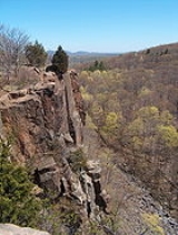
Views
Within Hamden's Sleeping Giant park, the trail—designated as the "Blue Trail" among the park's system of trails with variously colored rectangular blazes, and variously shaped red ones, passes such dramatic overlooks as Hezekiah's Knob (680 feet, at 41°26'3.00"N 72°52'25.89"W) and the stone Tower (739 feet at its ground floor). The giant's "chin" (670 ft) offers steep climbs, sweeping southwesterly views of the Quinnipiac UniversityQuinnipiac University
Quinnipiac University is a private, nonsectarian, coeducational university located in Hamden, Connecticut, United States at the foot of Sleeping Giant State Park...
campus and beyond to Long Island Sound
Long Island Sound
Long Island Sound is an estuary of the Atlantic Ocean, located in the United States between Connecticut to the north and Long Island, New York to the south. The mouth of the Connecticut River at Old Saybrook, Connecticut, empties into the sound. On its western end the sound is bounded by the Bronx...
. The trail descends on relatively on an exposed slope along an abandoned quarry to the Mill River, west along Mt. Carmel Ave. in Hamden
Hamden, Connecticut
Hamden is a town in New Haven County, Connecticut, United States. The town's nickname is "The Land of the Sleeping Giant." Hamden is home to Quinnipiac University. The population was 58,180 according to the Census Bureau's 2005 estimates...
, intersecting with both Whitney Avenue (Route 10), and the Farmington Canal
Farmington Canal
The Farmington Canal, also known as the New Haven and Northampton Canal, was a major private canal built in the early 19th century to provide water transportation from New Haven into the interior of Connecticut, Massachusetts and beyond. Its Massachusetts segment was known as the Hampshire and...
Greenway.
Between Whitney Avenue westward to Shepard Avenue (1.3 miles), the trail ascends Rocky Top, site of the Quinnipiac University hockey/basketball arena, the TD Bank Sports Center, opened in January, 2007 (also accessible by vehicle from Sherman Avenue). Since the clearing of surrounding land in 2007, the pinnacle of this 234 acre (0.94696524 km²), future-campus site rises well above the stadium structures, affording 360 degree views.
To the northeast, the distinctive Metacomet Ridge
Metacomet Trail
The Metacomet Trail is a Blue-Blazed hiking trail that traverses the Metacomet Ridge of central Connecticut and is a part of the newly designated New England National Scenic Trail. Despite being easily accessible and close to large population centers, the trail is considered remarkably rugged and...
is visible in Meriden
Meriden, Connecticut
Meriden is a city in New Haven County, Connecticut, United States. According to 2005 Census Bureau estimates, the population of the city is 59,653.-History:...
, 14.4 miles (23.2 km) from this point. To the ENE is a view of the traprock
Basalt
Basalt is a common extrusive volcanic rock. It is usually grey to black and fine-grained due to rapid cooling of lava at the surface of a planet. It may be porphyritic containing larger crystals in a fine matrix, or vesicular, or frothy scoria. Unweathered basalt is black or grey...
quarry on the west-facing side (or "top") of the Sleeping Giant's head. To the east lies the original Quinnipiac University campus, with its signature white steeple.
Due south is the familiar landmark of East Rock
East Rock Park
East Rock Park is a park in the city of New Haven and the town of Hamden, Connecticut that is operated as a New Haven city park. The park surrounds and includes the mountainous ridge named East Rock and was developed with naturalistic landscaping....
(6.1 miles), once a sacred site of the native Quinnipiac tribe, called "Rotenburg", by Dutch explorers in the early 17th century, for its red, rocky cliffs. Atop East Rock stands the Civil War
American Civil War
The American Civil War was a civil war fought in the United States of America. In response to the election of Abraham Lincoln as President of the United States, 11 southern slave states declared their secession from the United States and formed the Confederate States of America ; the other 25...
Soldiers and Sailors Monument
Soldiers and Sailors Monument (New Haven)
The Soldiers and Sailors Monument, located on the summit of East Rock in New Haven, Connecticut, is visible for miles from the surrounding urban metropolis and Long Island Sound. The monument was built in 1887 and honors the residents of New Haven who gave their lives in the Revolutionary War, the...
with its tall, thin column of the Angel of Victory, refurbished in 2006. The New Haven
New Haven, Connecticut
New Haven is the second-largest city in Connecticut and the sixth-largest in New England. According to the 2010 Census, New Haven's population increased by 5.0% between 2000 and 2010, a rate higher than that of the State of Connecticut, and higher than that of the state's five largest cities, and...
skyline is silhouetted against its shimmering harbor on the Sound. Beyond, (31 miles) across the Sound lie the distant dunes of North Shore Beach in Long Island
Long Island
Long Island is an island located in the southeast part of the U.S. state of New York, just east of Manhattan. Stretching northeast into the Atlantic Ocean, Long Island contains four counties, two of which are boroughs of New York City , and two of which are mainly suburban...
.
To the south-southwest can be seen the undulating forests of West Rock Ridge State Park
West Rock Ridge State Park
West Rock Ridge State Park is a state park located in New Haven, Hamden, and Woodbridge, Connecticut. It is named for the trap rock West Rock Ridge, which is part of the Metacomet Ridge extending from Long Island Sound to the Vermont border. The ridge consists largely of diabase basalt, much like...
, site of the Regicides Trail
Regicides Trail
Regicides Trail is a Blue-Blazed hiking trail, about 7 miles long, roughly following the edge of a basalt, or traprock, cliff northwest of New Haven, Connecticut. It is named for two regicides, Edward Whalley and his son-in-law William Goffe, who signed the death warrant of King Charles I of England...
. At its southwest extremity, the QT connects with the Regicides Trail, along the West Rock Ridge. A cell tower marks the approximate location of Judges' Cave.
Recognition / Inspiration Programs
The Connecticut Forest and Park AssociationConnecticut Forest and Park Association
The Connecticut Forest and Park Association , established in 1895, is the oldest private, nonprofit conservation organization in Connecticut. The organization is credited as an important early pioneer of the national land conservation movement and as an early advocate of long distance trail building...
(CFPA) provides commemorative patches as recognition to hikers completing the entire length of one of the three original Blue-Blazed trails in Connecticut (Quinnipiac, Metacomet and Mattabesett). The Quinnipiac Trail patch can be obtained for a small fee ($1) after the hiking the entire trail is completed by contacting the Connecticut Forest and Park Association
Connecticut Forest and Park Association
The Connecticut Forest and Park Association , established in 1895, is the oldest private, nonprofit conservation organization in Connecticut. The organization is credited as an important early pioneer of the national land conservation movement and as an early advocate of long distance trail building...
.
The Sleeping Giant Park Association (SGPA) recognizes member hikers who have hiked all of the color-blazed trails in Sleeping Giant State Park including the Quinnipiac Trail section (AKA "Blue Trail") with a "Giant Master" certificate and an entry on the "Giant Masters" list webpage. The Giant Master Log form for recording hikes for submission can be obtained as a PDF file.
See also
- Blue-Blazed TrailsBlue-Blazed TrailsThe Blue-Blazed trail system, managed by the Connecticut Forest and Park Association, and the related trail systems documented in the two volume 19th Edition of the "Connecticut Walk Book" comprise over 800 miles of hiking trails in Connecticut.There are now over 825 miles of CFPA Blue-Blazed...
- Sleeping Giant State Park
- Quinnipiac River State Park
- Quinnipiac RiverQuinnipiac RiverThe Quinnipiac River is a river in the New England region of the United States, located entirely in the state of Connecticut.It rises in west central Connecticut from Dead Wood Swamp west of the city of New Britain...
External links
Specific to this trail:- Shelton Trails BlogSpot articles on the Quinnipiac Trail
- Sleeping Giant Park Association