
Port Stephens
Encyclopedia
Port Stephens is a large natural harbour located about 160 kilometres (99 mi) north-east of Sydney
in New South Wales
, Australia
. It lies wholly within the Port Stephens Local Government Area (LGA) although its northern shoreline forms the boundary between the Port Stephens and Great Lakes LGAs. More than 26,000 people live within 3 km (1.9 mi) of its 113 km (70.2 mi) long shoreline and more than 32,000 live within 10 km (6 mi).
(AMSL) while "Yacaaba", the northern headland, is 210 m (689 ft) AMSL. The harbour is mostly shallow and sandy but contains sufficient deep water to accommodate large vessels; the RMS Queen Mary
moored there during World War II
. After its recovery from the wreck site in 1974 the bow of the , a 53,000 tonne Norwegian
bulk carrier
that was shipwreck
ed on Stockton Beach earlier that year, was moored in Port Stephens, at Salamander Bay
, for almost two years.
With an area of approximately 119 square kilometres (46 sq mi) Port Stephens is larger than Sydney Harbour
. It extends approximately 24 km (14.9 mi) inland from the Tasman Sea
and at its widest point, between Tanilba Bay
and Tahlee
, it is 6.5 km (4 mi) across. The narrowest point is between Soldiers Point
and Pindimar where the distance is only 1.1 km (0.683510010314787 mi). Between Nelson Bay
and Tea Gardens
, in the most well known section of the port, it is 3.8 km (2.4 mi) wide.
The Karuah River
drains into Port Stephens at its north-western corner. The Myall River
(through the Myall Lakes
) drains into the port on its northern shore, about 5.7 km (3.5 mi) from the mouth of the port. Twelve Mile Creek drains into the port's south-western corner.
 The southern shore of the port is divided into two distinct areas known as the Tomaree and Tilligerry peninsulas. These are separated by Tilligerry Creek, a body of water covering approximately 7.7 km² (3 sq mi), which drains the land in the low-lying areas of Salt Ash
, Bobs Farm
, Tanilba Bay and Mallabula
. While it is geographically closer to major centres such as Sydney
and Newcastle
the Tilligerry peninsula lacks the urban development that has occurred on the much larger (25 km² (10 sq mi) vs 115 km² (44 sq mi) respectively) Tomaree peninsula. Although Lemon Tree Passage, on the Tilligerry Peninsula, and Soldiers Point, on the Tomaree Peninsula, are only 2.9 km (1.8 mi) from each other, physical separation of the suburbs by Port Stephens and Tilligerry Creek results in them being almost 40 km (25 mi) from each other by road.
Karuah
township, located at the north-western corner of the port on the mouth of the Karuah River, experiences similar geographical separation from the Tilligerry Peninsula. Despite being only 7.7 km (4.8 mi) from Tanilba Bay, the road distance between the two suburbs is 40 km (25 mi).
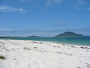
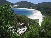
The western shore and the western part of the northern shore of the port are largely undeveloped with the flora ranging from scrubland in the west to the large tracts of bushland
which are present along most of the northern shore. Closer to the mouth of the port, at and near Winda Woppa, sandy beaches are prevalent. These extend from Jimmys Beach, near the mouth of the port, to the mouth of the Myall River, a distance of approximately 5.2 km (3.2 mi). Just outside the mouth of the port lie the two small insular nature reserve
s of Cabbage Tree Island
and Boondelbah Island
, both dedicated to the conservation of the threatened Gould's Petrel
, and with no public access.
when he passed on 11 May 1770, honouring Sir Philip Stephens, who was Secretary to the Admiralty. Stephens was a personal friend of Cook and had recommended him for command of the voyage. It seems Cook's initial choice had actually been Point Keppel and Keppel Bay, but instead he used Keppel Bay
later.
The first ship to enter the port was the Salamander, a ship of the Third Fleet
that later gave the suburb of Salamander Bay its name, in 1791. In that same year escaped convicts, then known as 'bolters', discovered coal in the area.
In 1795 the crew of the HMS Providence discovered a group of escaped convicts, living with the Worimi people
. Port Stephens became a popular haven for escaped convicts and so in 1820 a garrison of soldiers was established at what is now known as Soldiers Point.
The 63 tonnes (62 LT) cutter Lambton, commanded by Captain James Corlette, began shipping timber and wool out of the port in 1816. The suburb of Corlette was named after the captain.
Port Stephens has rather poor soil for the most part, and has limited agricultural potential. For this reason, no large towns developed there historically and it was never developed as a significant port. The major city and port of Newcastle
developed at the mouth of the Hunter River, about 45 km (28 mi) south-west of Port Stephens.
.jpg) Despite this, in 1920 there was a push for Port Stephens to be the capital city of a new state in a proposal originating from the country newspaper The Daily Observer. The proposal was the Observers editor Victor Charles Thompson's idea in response to continuing rural Australian antipathy at the Sydney-centralised funding and governance that many rural newspapers claimed had neglected to aid rural Australian towns.
Despite this, in 1920 there was a push for Port Stephens to be the capital city of a new state in a proposal originating from the country newspaper The Daily Observer. The proposal was the Observers editor Victor Charles Thompson's idea in response to continuing rural Australian antipathy at the Sydney-centralised funding and governance that many rural newspapers claimed had neglected to aid rural Australian towns.
During World War II, the remoteness and lack of any significant civilian population lead to the Royal Australian Navy
establishing HMAS Assault
, an amphibious landing training establishment, at Nelson Bay. The Sick Bay from HMAS Assault still stands and is used by the Port Stephens Community Arts Centre.
A number of small towns developed around the port as fishing, holiday and retirement communities. Since the 1970s, with improved road access from Sydney, and the increasing popularity of coastal retirement lifestyles, there has been major expansion of these towns.
from just south of Forster
to the northern end of Stockton Beach.
 According to the Australian Bureau of Statistics
, at the time of the 2006 Census, more than 85% of the population around Port Stephens resided in towns and suburbs that have developed on or near the southern shores of the port. More than 22,188 people live within 3 km (1.9 mi) of the port in the suburbs of Corlette
, Lemon Tree Passage
, Mallabula, Nelson Bay, Oyster Cove, Salamander Bay, Shoal Bay
, Soldiers Point, Tanilba Bay and Taylors Beach
. Another 5,343 people live in other suburbs on the Tomaree peninsula that are within 10 km (6 mi) of Port Stephens. These suburbs include Anna Bay
, Boat Harbour
, Bobs Farm, Fingal Bay
, Fishermans Bay
and One Mile
.
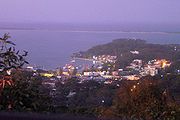
Most urban development to the south of Port Stephens has occurred on the Tomaree peninsula in the suburbs of Corlette, Nelson Bay, Salamander Bay, Shoal Bay and Soldiers Point.
On the western shore is the suburb of Swan Bay, a small community of around 100 persons. The main industry in the area is oyster
farming, however a small tourist resort is located near the mouth of Twelve Mile Creek. Karuah township, which has a population of 857, is at the north-western corner of the port, at the mouth of the Karuah River.
East of the Karuah River, in the Great Lakes Council LGA there are 3,584 people living in Bundabah, Carrington, Hawks Nest
, North Arm Cove
, Pindimar, Tahlee and Tea Gardens.
 Port Stephens is a popular tourism destination with a strong focus on aquatic activities such as whale and dolphin
watching, fishing and recreational boating.
Sydney
Sydney is the most populous city in Australia and the state capital of New South Wales. Sydney is located on Australia's south-east coast of the Tasman Sea. As of June 2010, the greater metropolitan area had an approximate population of 4.6 million people...
in New South Wales
New South Wales
New South Wales is a state of :Australia, located in the east of the country. It is bordered by Queensland, Victoria and South Australia to the north, south and west respectively. To the east, the state is bordered by the Tasman Sea, which forms part of the Pacific Ocean. New South Wales...
, Australia
Australia
Australia , officially the Commonwealth of Australia, is a country in the Southern Hemisphere comprising the mainland of the Australian continent, the island of Tasmania, and numerous smaller islands in the Indian and Pacific Oceans. It is the world's sixth-largest country by total area...
. It lies wholly within the Port Stephens Local Government Area (LGA) although its northern shoreline forms the boundary between the Port Stephens and Great Lakes LGAs. More than 26,000 people live within 3 km (1.9 mi) of its 113 km (70.2 mi) long shoreline and more than 32,000 live within 10 km (6 mi).
Geography
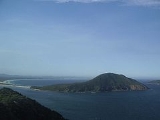
Port Stephens has a narrow entrance between two striking hills of volcanic origin. The southern headland, "Tomaree" or "South" Head, rises to 120 metres (393.7 ft) above mean sea levelAbove mean sea level
The term above mean sea level refers to the elevation or altitude of any object, relative to the average sea level datum. AMSL is used extensively in radio by engineers to determine the coverage area a station will be able to reach...
(AMSL) while "Yacaaba", the northern headland, is 210 m (689 ft) AMSL. The harbour is mostly shallow and sandy but contains sufficient deep water to accommodate large vessels; the RMS Queen Mary
RMS Queen Mary
RMS Queen Mary is a retired ocean liner that sailed primarily in the North Atlantic Ocean from 1936 to 1967 for the Cunard Line...
moored there during World War II
World War II
World War II, or the Second World War , was a global conflict lasting from 1939 to 1945, involving most of the world's nations—including all of the great powers—eventually forming two opposing military alliances: the Allies and the Axis...
. After its recovery from the wreck site in 1974 the bow of the , a 53,000 tonne Norwegian
Norway
Norway , officially the Kingdom of Norway, is a Nordic unitary constitutional monarchy whose territory comprises the western portion of the Scandinavian Peninsula, Jan Mayen, and the Arctic archipelago of Svalbard and Bouvet Island. Norway has a total area of and a population of about 4.9 million...
bulk carrier
Bulk carrier
A bulk carrier, bulk freighter, or bulker is a merchant ship specially designed to transport unpackaged bulk cargo, such as grains, coal, ore, and cement in its cargo holds. Since the first specialized bulk carrier was built in 1852, economic forces have fueled the development of these ships,...
that was shipwreck
Shipwreck
A shipwreck is what remains of a ship that has wrecked, either sunk or beached. Whatever the cause, a sunken ship or a wrecked ship is a physical example of the event: this explains why the two concepts are often overlapping in English....
ed on Stockton Beach earlier that year, was moored in Port Stephens, at Salamander Bay
Salamander Bay, New South Wales
Salamander Bay is a suburb of the Port Stephens Local Government Area in the Hunter Region of New South Wales, Australia. Named after the adjacent shallow bay, itself named after the Salamander, a convict ship from the Third Fleet, which was the first European vessel to enter Port Stephens , it is...
, for almost two years.
With an area of approximately 119 square kilometres (46 sq mi) Port Stephens is larger than Sydney Harbour
Port Jackson
Port Jackson, containing Sydney Harbour, is the natural harbour of Sydney, Australia. It is known for its beauty, and in particular, as the location of the Sydney Opera House and Sydney Harbour Bridge...
. It extends approximately 24 km (14.9 mi) inland from the Tasman Sea
Tasman Sea
The Tasman Sea is the large body of water between Australia and New Zealand, approximately across. It extends 2,800 km from north to south. It is a south-western segment of the South Pacific Ocean. The sea was named after the Dutch explorer Abel Janszoon Tasman, the first recorded European...
and at its widest point, between Tanilba Bay
Tanilba Bay, New South Wales
Tanilba Bay is a suburb of the Port Stephens Local Government Area in the Hunter Region of New South Wales, Australia. It is located on the Tilligerry Peninsula adjacent to the bay from which it got its name...
and Tahlee
Tahlee, New South Wales
Tahlee is a suburb of the Great Lakes Council Local Government Area in the Hunter and Mid North Coast regions of New South Wales, Australia, located on the northern shores of Port Stephens. The suburb is sparsely populated with the only significant population centre being the property of Tahlee,...
, it is 6.5 km (4 mi) across. The narrowest point is between Soldiers Point
Soldiers Point, New South Wales
Soldiers Point is a suburb of the Port Stephens Local Government Area in the Hunter Region of New South Wales, Australia. Located on the southern shores of Port Stephens it is almost entirely surrounded by the port and is a popular location for fishing and boating...
and Pindimar where the distance is only 1.1 km (0.683510010314787 mi). Between Nelson Bay
Nelson Bay, New South Wales
Nelson Bay is a suburb of the Port Stephens Local Government Area in the Hunter Region of New South Wales, Australia. It is located on a bay of the same name on the southern shore of Port Stephens about by road north-east of Newcastle, its nearest rail link. At the 2006 census, Nelson Bay had a...
and Tea Gardens
Tea Gardens, New South Wales
Tea Gardens is a locality in the Great Lakes Council Local Government Area, located near the southern extremity of the Mid North Coast and the northern extremity of the Hunter Region in New South Wales, Australia....
, in the most well known section of the port, it is 3.8 km (2.4 mi) wide.
The Karuah River
Karuah River
The Karuah River is a major river in the Great Lakes Area of the Australian state of New South Wales. It is fed by numerous creeks and streams on the south side of the Gloucester Tops Ranges which makes up part of the Great Dividing Range....
drains into Port Stephens at its north-western corner. The Myall River
Myall River
The Myall River is a river on the mid-North Coast of the Australian state of New South Wales that empties into Port Stephens, near its mouth with the Tasman Sea.As well as flowing into the Myall Lakes, a number of important settlements exist on the river:...
(through the Myall Lakes
Myall Lakes
The Myall Lakes are a series of fresh water lakes on the mid-north coast of New South Wales, Australia in Great Lakes Council. The lakes are adjacent to the coast about north of Sydney....
) drains into the port on its northern shore, about 5.7 km (3.5 mi) from the mouth of the port. Twelve Mile Creek drains into the port's south-western corner.
Salt Ash, New South Wales
Salt Ash is a rural suburb of the Port Stephens Local Government Areas in the Hunter Region of New South Wales, Australia. It is located on the main road between Newcastle and Nelson Bay but is largely undeveloped, partly because it is the location of the Salt Ash Air Weapons Range which is used...
, Bobs Farm
Bobs Farm, New South Wales
Bobs Farm is a sparsely populated rural suburb of the Port Stephens Local Government Area in the Hunter Region of New South Wales, Australia. It is located on the main road between Newcastle and Nelson Bay home to a number of small, boutique style vineyards and wineries and a thriving aquaculture...
, Tanilba Bay and Mallabula
Mallabula, New South Wales
Mallabula is a primarily residential suburb of the Port Stephens Local Government Area in the Hunter Region of New South Wales, Australia. It is located on the Tilligerry Peninsula between Lemon Tree Passage and Tanilba Bay.-Geography:...
. While it is geographically closer to major centres such as Sydney
Sydney
Sydney is the most populous city in Australia and the state capital of New South Wales. Sydney is located on Australia's south-east coast of the Tasman Sea. As of June 2010, the greater metropolitan area had an approximate population of 4.6 million people...
and Newcastle
Newcastle, New South Wales
The Newcastle metropolitan area is the second most populated area in the Australian state of New South Wales and includes most of the Newcastle and Lake Macquarie Local Government Areas...
the Tilligerry peninsula lacks the urban development that has occurred on the much larger (25 km² (10 sq mi) vs 115 km² (44 sq mi) respectively) Tomaree peninsula. Although Lemon Tree Passage, on the Tilligerry Peninsula, and Soldiers Point, on the Tomaree Peninsula, are only 2.9 km (1.8 mi) from each other, physical separation of the suburbs by Port Stephens and Tilligerry Creek results in them being almost 40 km (25 mi) from each other by road.
Karuah
Karuah, New South Wales
Karuah is a predominantly rural locality of both the Port Stephens and Great Lakes Councils in the Hunter Region of New South Wales, Australia. It is thought that the name means 'native plum tree' in the local Aboriginal dialect.-Geography:...
township, located at the north-western corner of the port on the mouth of the Karuah River, experiences similar geographical separation from the Tilligerry Peninsula. Despite being only 7.7 km (4.8 mi) from Tanilba Bay, the road distance between the two suburbs is 40 km (25 mi).
The western shore and the western part of the northern shore of the port are largely undeveloped with the flora ranging from scrubland in the west to the large tracts of bushland
Bushland
Bushland is any area in Australia that is predominantly indigenous flora and fauna.Bushland is the term commonly used by conservation protection groups and other environmental groups as a blanket term for natural vegetation, which may cover any kind of habitat from open shrubby country with few...
which are present along most of the northern shore. Closer to the mouth of the port, at and near Winda Woppa, sandy beaches are prevalent. These extend from Jimmys Beach, near the mouth of the port, to the mouth of the Myall River, a distance of approximately 5.2 km (3.2 mi). Just outside the mouth of the port lie the two small insular nature reserve
Nature reserve
A nature reserve is a protected area of importance for wildlife, flora, fauna or features of geological or other special interest, which is reserved and managed for conservation and to provide special opportunities for study or research...
s of Cabbage Tree Island
Cabbage Tree Island
Cabbage Tree Island, also known as the John Gould Nature Reserve, is an uninhabited island with an area of 300,000 m2 lying 1.4 km off the mouth of Port Stephens on the coast of New South Wales, Australia. It is named for the Cabbage-tree Palms which are a feature of the island’s rainforest...
and Boondelbah Island
Boondelbah Island
Boondelbah Island, also known as the Boondelbah Nature Reserve, is an uninhabited 14 ha island lying 2 km off the mouth of Port Stephens on the coast of New South Wales, Australia...
, both dedicated to the conservation of the threatened Gould's Petrel
Gould's Petrel
Gould's Petrel is a species of seabird in the Procellariidae family. It is a small petrel, 30 cm long with a wingspan of about 70 cm. It is largely grey above and white below with a blackish crown and hindneck and a black M-shaped band across the wings and rump.The subspecies P. l...
, and with no public access.
History
The port was named by Captain CookJames Cook
Captain James Cook, FRS, RN was a British explorer, navigator and cartographer who ultimately rose to the rank of captain in the Royal Navy...
when he passed on 11 May 1770, honouring Sir Philip Stephens, who was Secretary to the Admiralty. Stephens was a personal friend of Cook and had recommended him for command of the voyage. It seems Cook's initial choice had actually been Point Keppel and Keppel Bay, but instead he used Keppel Bay
Keppel Bay
Keppel Bay is a broad bay in Central Queensland, Australia at the mouth of the Fitzroy River. Cape Keppel is at the Eastern end of the bay.The bay and the nearby Keppel Islands were named by Captain Cook when he was there on 27 May 1770, after Admiral Augustus Keppel of the British Royal...
later.
The first ship to enter the port was the Salamander, a ship of the Third Fleet
Third Fleet (Australia)
The Third Fleet consisted of 11 ships which set sail from United Kingdom in February, March and April 1791 bound for the Sydney penal settlement, with over 2000 convicts. The passengers consisted of convicts, military personnel and notable people sent to fill high positions in the colony...
that later gave the suburb of Salamander Bay its name, in 1791. In that same year escaped convicts, then known as 'bolters', discovered coal in the area.
In 1795 the crew of the HMS Providence discovered a group of escaped convicts, living with the Worimi people
Worimi people
Worimi people are Indigenous Australians from the eastern Port Stephens and Great Lakes regions of coastal New South Wales, Australia. Before contact with settlers, their people extended from Port Stephens in the south to Forster/Tuncurry in the north and as far west as Gloucester...
. Port Stephens became a popular haven for escaped convicts and so in 1820 a garrison of soldiers was established at what is now known as Soldiers Point.
The 63 tonnes (62 LT) cutter Lambton, commanded by Captain James Corlette, began shipping timber and wool out of the port in 1816. The suburb of Corlette was named after the captain.
Port Stephens has rather poor soil for the most part, and has limited agricultural potential. For this reason, no large towns developed there historically and it was never developed as a significant port. The major city and port of Newcastle
Newcastle, New South Wales
The Newcastle metropolitan area is the second most populated area in the Australian state of New South Wales and includes most of the Newcastle and Lake Macquarie Local Government Areas...
developed at the mouth of the Hunter River, about 45 km (28 mi) south-west of Port Stephens.
During World War II, the remoteness and lack of any significant civilian population lead to the Royal Australian Navy
Royal Australian Navy
The Royal Australian Navy is the naval branch of the Australian Defence Force. Following the Federation of Australia in 1901, the ships and resources of the separate colonial navies were integrated into a national force: the Commonwealth Naval Forces...
establishing HMAS Assault
HMAS Assault
HMAS Assault was a Royal Australian Navy Naval Training Centre at Nelson Bay in the Port Stephens area of New South Wales, Australia during World War II....
, an amphibious landing training establishment, at Nelson Bay. The Sick Bay from HMAS Assault still stands and is used by the Port Stephens Community Arts Centre.
A number of small towns developed around the port as fishing, holiday and retirement communities. Since the 1970s, with improved road access from Sydney, and the increasing popularity of coastal retirement lifestyles, there has been major expansion of these towns.
Port Stephens-Great Lakes Marine Park
On 1 December 2005 the Port Stephens-Great Lakes Marine Park was established. The park includes all of Port Stephens, the Karuah and Myall rivers and all their creeks and tributaries under tidal influence. The park was established to protect the wide variety of sea life that inhabit the port and nearby coastal areas of the Tasman SeaTasman Sea
The Tasman Sea is the large body of water between Australia and New Zealand, approximately across. It extends 2,800 km from north to south. It is a south-western segment of the South Pacific Ocean. The sea was named after the Dutch explorer Abel Janszoon Tasman, the first recorded European...
from just south of Forster
Forster, New South Wales
Forster is a large coastal town in the Mid North Coast region of New South Wales, Australia, in the Great Lakes Council LGA, about north-north-east of Sydney. It is immediately adjacent to its twin, Tuncurry, which is the smaller of the two towns...
to the northern end of Stockton Beach.
Demographics
Australian Bureau of Statistics
The Australian Bureau of Statistics is Australia's national statistical agency. It was created as the Commonwealth Bureau of Census and Statistics on 8 December 1905, when the Census and Statistics Act 1905 was given Royal assent. It had its beginnings in section 51 of the Constitution of Australia...
, at the time of the 2006 Census, more than 85% of the population around Port Stephens resided in towns and suburbs that have developed on or near the southern shores of the port. More than 22,188 people live within 3 km (1.9 mi) of the port in the suburbs of Corlette
Corlette, New South Wales
Corlette is a suburb of the Port Stephens Local Government Area in the Hunter Region of New South Wales, Australia. It is located just west of Nelson Bay on the shores of Port Stephens. It was named after Captain James Corlette who skippered the cutter Lambton which was the first privately owned...
, Lemon Tree Passage
Lemon Tree Passage, New South Wales
Lemon Tree Passage is a suburb of the Port Stephens Local Government Area in the Hunter Region of New South Wales, Australia, located at the end of the Tilligerry Peninsula and surrounded by the waters of Port Stephens. It is a haven for koalas due to it being densely wooded...
, Mallabula, Nelson Bay, Oyster Cove, Salamander Bay, Shoal Bay
Shoal Bay, New South Wales
Shoal Bay is the most eastern suburb of the Port Stephens Local Government Area in the Hunter Region of New South Wales, Australia. It is located on the southern shore of Port Stephens, adjacent to the bay of the same name at the entrance to the port...
, Soldiers Point, Tanilba Bay and Taylors Beach
Taylors Beach, New South Wales
Taylors Beach is a suburb of the Port Stephens Local Government Area in the Hunter Region of New South Wales, Australia. It is largely undeveloped except for some commercial and light industrial developments in the southern part of the suburb. The largest population centre is at Taylor's Beach...
. Another 5,343 people live in other suburbs on the Tomaree peninsula that are within 10 km (6 mi) of Port Stephens. These suburbs include Anna Bay
Anna Bay, New South Wales
Anna Bay is the name of a suburb, a town and a bay in the Port Stephens Local Government Area in the Hunter Region of New South Wales, Australia. It is immediately adjacent to the north-eastern end of Stockton Beach and the town provides one of the major entry points to the beach here...
, Boat Harbour
Boat Harbour, New South Wales
Boat Harbour is a suburb of the Port Stephens Local Government Area in the Hunter Region of New South Wales, Australia. The main population centre of the suburb is the village also known as Boat Harbour...
, Bobs Farm, Fingal Bay
Fingal Bay, New South Wales
Fingal Bay is the eastern-most suburb of the Port Stephens Local Government Area in the Hunter Region of New South Wales, Australia. The only population centre is the township of the same name, which itself is named after the adjacent, small, semi-circular bay...
, Fishermans Bay
Fishermans Bay, New South Wales
Fishermans Bay is a small suburb of the Port Stephens Local Government Area in the Hunter Region of New South Wales, Australia. It is located on the coast of the Tasman Sea adjacent to Anna Bay. A large part of the eastern portion of the suburb is occupied by Tomaree National Park and only a very...
and One Mile
One Mile, New South Wales
One Mile is a suburb of the Port Stephens Local Government Area in the Hunter Region of New South Wales, Australia. The suburb is semi-rural with a small urban settlement west of Gan Gan Road and a number of caravan parks to the east of Gan Gan Road...
.
Most urban development to the south of Port Stephens has occurred on the Tomaree peninsula in the suburbs of Corlette, Nelson Bay, Salamander Bay, Shoal Bay and Soldiers Point.
On the western shore is the suburb of Swan Bay, a small community of around 100 persons. The main industry in the area is oyster
Oyster
The word oyster is used as a common name for a number of distinct groups of bivalve molluscs which live in marine or brackish habitats. The valves are highly calcified....
farming, however a small tourist resort is located near the mouth of Twelve Mile Creek. Karuah township, which has a population of 857, is at the north-western corner of the port, at the mouth of the Karuah River.
East of the Karuah River, in the Great Lakes Council LGA there are 3,584 people living in Bundabah, Carrington, Hawks Nest
Hawks Nest, New South Wales
Hawks Nest is a suburb of the Great Lakes Council Local Government Area in the Hunter and Mid North Coast regions of New South Wales, Australia, located north of Port Stephens between the Tasman Sea and the Myall River...
, North Arm Cove
North Arm Cove, New South Wales
North Arm Cove is a suburb of the Great Lakes Council Local Government Area in the Hunter and Mid North Coast regions of New South Wales, Australia, located adjacent to Port Stephens and extending well north of the Pacific Highway....
, Pindimar, Tahlee and Tea Gardens.
Tourism and recreation
Dolphin
Dolphins are marine mammals that are closely related to whales and porpoises. There are almost forty species of dolphin in 17 genera. They vary in size from and , up to and . They are found worldwide, mostly in the shallower seas of the continental shelves, and are carnivores, mostly eating...
watching, fishing and recreational boating.