
Poor Knights Islands
Encyclopedia
The Poor Knights Islands are a group of island
s off the east coast of the Northland Region of the North Island
of New Zealand
. They are located 50 kilometres (31.1 mi) to the northeast of Whangarei
, and lie 22 kilometres (13.7 mi) offshore half way between Bream Head
and Cape Brett
. Uninhabited since the 1820s, they are a nature reserve
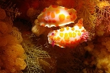
and popular underwater diving
spot. The Poor Knights Islands Marine Reserve
surrounds the island.
The chain consists of two large islands (Tawhiti Rahi, the larger at 151.5 ha (374.4 acre), and Aorangi (101 ha (249.6 acre))) with a group of smaller islets between the two, the largest of which is Motu Kapiti. Tawhiti Rahi is also the Māori
name for the entire chain, which has a total area of 271 ha (669.7 acre). The islands are the eroded remnants of a 4 million year old rhyolitic
volcano
.
The islands' name is said to derive from their resemblance to Poor Knight's Pudding
, a bread-based dish popular at the time of discovery by Europeans.
The islands are protected as a nature reserve and a permit is required to land or tie boats up. Permits are usually granted only for scientific research. A notable native plant of the islands is the spectacularly-flowering Poor Knights lily. Feral pigs, which had roamed Aorangi since the departure of Māori in the 1820s, were exterminated in 1936.
tribe who grew crops and fished the surrounding sea. The tribe traded with other Maori.
A chief of the tribe named Tatua led his warriors on a fighting expedition to the Hauraki Gulf
with Ngā Puhi chief Hongi Hika
in the early 1820s. While they were away, a slave escaped the islands and travelled to Hokianga
where he told Waikato, a chief of the Hikutu tribe, that the islands had been left undefended. As Waikato had been offended by Tatua some years previous, he and his warriors set out on three large canoe
s to attack the islands. They arrived at the islands one night in December 1823 and soon overpowered the islanders in the absence of their warriors. Many islanders jumped off the high cliffs to avoid being taken as slaves. Tatua's wife and daughter were captured and taken to the mainland where a distant relative recognised the wife and helped the two to escape.
Tatua returned to the islands to find a scene of destruction. Only nine or ten people were left on the islands, including his five year old son who had been hidden in a cave during the attack. The islands were declared tapu and Tatua left with the survivors and went to Rawhiti
in the Bay of Islands
where he unexpectedly found his wife and daughter.
range for the islands is around 2 m (6.56 ft), decreasing to a neap tide of around 1 m (3.28 ft). The deep water around the island results in only moderate tidal currents. These are around the same magnitude as the prevailing shelf currents. In the general vicinity of the islands mean flows are around 0.2 m/s (0.656167979002625 ft/s) and run toward the southeast. A remakable feature of the region is the large internal tides that occur. These are a form of internal wave
driven by the local tidal flow forcing the stratification against sloping areas of the shelf face. The surface manifestation of these waves can be seen from space. These waves generate brief highly-localized accelerations. Internal wave amplitudes of around 100 m (109 yd) have been observed, generating flow speeds as great as 0.5 m/s (1.64 ft/s).
Island
An island or isle is any piece of sub-continental land that is surrounded by water. Very small islands such as emergent land features on atolls can be called islets, cays or keys. An island in a river or lake may be called an eyot , or holm...
s off the east coast of the Northland Region of the North Island
North Island
The North Island is one of the two main islands of New Zealand, separated from the much less populous South Island by Cook Strait. The island is in area, making it the world's 14th-largest island...
of New Zealand
New Zealand
New Zealand is an island country in the south-western Pacific Ocean comprising two main landmasses and numerous smaller islands. The country is situated some east of Australia across the Tasman Sea, and roughly south of the Pacific island nations of New Caledonia, Fiji, and Tonga...
. They are located 50 kilometres (31.1 mi) to the northeast of Whangarei
Whangarei
Whangarei, pronounced , is the northernmost city in New Zealand and the regional capital of Northland Region. Although commonly classified as a city, it is officially part of the Whangarei District, administered by the Whangarei District Council a local body created in 1989 to administer both the...
, and lie 22 kilometres (13.7 mi) offshore half way between Bream Head
Bream Head
Bream Head is a promontory on the east coast of Northland in the North Island of New Zealand. Located at the end of a 30 kilometre-long peninsula, the head juts into the Pacific Ocean to the southeast of Whangarei...
and Cape Brett
Cape Brett
Cape Brett is a promontory on the northern North Island coast in New Zealand. Located at the end of the Cape Brett Peninsula, the head extends north into the Pacific Ocean at the eastern end of the Bay of Islands....
. Uninhabited since the 1820s, they are a nature reserve
Nature reserve
A nature reserve is a protected area of importance for wildlife, flora, fauna or features of geological or other special interest, which is reserved and managed for conservation and to provide special opportunities for study or research...
and popular underwater diving
Underwater diving
Underwater diving is the practice of going underwater, either with breathing apparatus or by breath-holding .Recreational diving is a popular activity...
spot. The Poor Knights Islands Marine Reserve
Poor Knights Islands Marine Reserve
The Poor Knights Islands Marine Reserve is a protected area off the coast of the North Island of New Zealand. The reserve, established in 1981 and covering an area of 2400 ha, is administered by the Department of Conservation. It surrounds the Poor Knights Islands and adjacent rock stacks. It is...
surrounds the island.
The chain consists of two large islands (Tawhiti Rahi, the larger at 151.5 ha (374.4 acre), and Aorangi (101 ha (249.6 acre))) with a group of smaller islets between the two, the largest of which is Motu Kapiti. Tawhiti Rahi is also the Māori
Maori language
Māori or te reo Māori , commonly te reo , is the language of the indigenous population of New Zealand, the Māori. It has the status of an official language in New Zealand...
name for the entire chain, which has a total area of 271 ha (669.7 acre). The islands are the eroded remnants of a 4 million year old rhyolitic
Rhyolite
This page is about a volcanic rock. For the ghost town see Rhyolite, Nevada, and for the satellite system, see Rhyolite/Aquacade.Rhyolite is an igneous, volcanic rock, of felsic composition . It may have any texture from glassy to aphanitic to porphyritic...
volcano
Volcano
2. Bedrock3. Conduit 4. Base5. Sill6. Dike7. Layers of ash emitted by the volcano8. Flank| 9. Layers of lava emitted by the volcano10. Throat11. Parasitic cone12. Lava flow13. Vent14. Crater15...
.
The islands' name is said to derive from their resemblance to Poor Knight's Pudding
French toast
French toast or Eggy Bread, is a food made with bread and eggs. It is a Christmas time dessert in Portugal and Brazil.Where French toast is served as a sweet dish, milk, sugar, or cinnamon are also commonly added before frying, and it may be then topped with sugar, butter, fruit, syrup, or other...
, a bread-based dish popular at the time of discovery by Europeans.
The islands are protected as a nature reserve and a permit is required to land or tie boats up. Permits are usually granted only for scientific research. A notable native plant of the islands is the spectacularly-flowering Poor Knights lily. Feral pigs, which had roamed Aorangi since the departure of Māori in the 1820s, were exterminated in 1936.
History
The islands were earlier inhabited by Māori of the Ngāti WaiNgati Wai
Ngāti Wai is a Māori iwi of the east coast of the Northland Region of New Zealand. Its historical area stretched from Cape Brett in the north to Takatu Point on Tawharanui Peninsula in the south and out to Great Barrier Island, the Poor Knights Islands and other offshore islands.Descendants of...
tribe who grew crops and fished the surrounding sea. The tribe traded with other Maori.
A chief of the tribe named Tatua led his warriors on a fighting expedition to the Hauraki Gulf
Hauraki Gulf
The Hauraki Gulf is a coastal feature of the North Island of New Zealand. It has a total area of 4000 km², and lies between the Auckland Region, the Hauraki Plains, the Coromandel Peninsula and Great Barrier Island...
with Ngā Puhi chief Hongi Hika
Hongi Hika
Hongi Hika was a New Zealand Māori rangatira and war leader of the Ngāpuhi iwi . Hongi Hika used European weapons to overrun much of northern New Zealand in the first of the Musket Wars...
in the early 1820s. While they were away, a slave escaped the islands and travelled to Hokianga
Hokianga
Hokianga is an area surrounding the Hokianga Harbour, also known as The Hokianga River, a long estuarine drowned valley on the west coast in the north of the North Island of New Zealand....
where he told Waikato, a chief of the Hikutu tribe, that the islands had been left undefended. As Waikato had been offended by Tatua some years previous, he and his warriors set out on three large canoe
Canoe
A canoe or Canadian canoe is a small narrow boat, typically human-powered, though it may also be powered by sails or small electric or gas motors. Canoes are usually pointed at both bow and stern and are normally open on top, but can be decked over A canoe (North American English) or Canadian...
s to attack the islands. They arrived at the islands one night in December 1823 and soon overpowered the islanders in the absence of their warriors. Many islanders jumped off the high cliffs to avoid being taken as slaves. Tatua's wife and daughter were captured and taken to the mainland where a distant relative recognised the wife and helped the two to escape.
Tatua returned to the islands to find a scene of destruction. Only nine or ten people were left on the islands, including his five year old son who had been hidden in a cave during the attack. The islands were declared tapu and Tatua left with the survivors and went to Rawhiti
Rawhiti
Rawhiti is a small beachfront town about 27 km from Russell in the Bay of Islands of New Zealand, and is a holiday haven with beautiful beaches, spectacular views, sailing, fishing and water sports. Most of the land in the area is owned by Māori...
in the Bay of Islands
Bay of Islands
The Bay of Islands is an area in the Northland Region of the North Island of New Zealand. Located 60 km north-west of Whangarei, it is close to the northern tip of the country....
where he unexpectedly found his wife and daughter.
Oceanography
Spring tideTide
Tides are the rise and fall of sea levels caused by the combined effects of the gravitational forces exerted by the moon and the sun and the rotation of the Earth....
range for the islands is around 2 m (6.56 ft), decreasing to a neap tide of around 1 m (3.28 ft). The deep water around the island results in only moderate tidal currents. These are around the same magnitude as the prevailing shelf currents. In the general vicinity of the islands mean flows are around 0.2 m/s (0.656167979002625 ft/s) and run toward the southeast. A remakable feature of the region is the large internal tides that occur. These are a form of internal wave
Internal wave
Internal waves are gravity waves that oscillate within, rather than on the surface of, a fluid medium. They are one of many types of wave motion in stratified fluids . A simple example is a wave propagating on the interface between two fluids of different densities, such as oil and water...
driven by the local tidal flow forcing the stratification against sloping areas of the shelf face. The surface manifestation of these waves can be seen from space. These waves generate brief highly-localized accelerations. Internal wave amplitudes of around 100 m (109 yd) have been observed, generating flow speeds as great as 0.5 m/s (1.64 ft/s).
Flora and fauna
fauna- see Poor Knights Islands nonmarine fauna
External links
- "Geology – New Zealand's Geological History", from An Encyclopaedia of New Zealand, edited by A. H. McLintock, originally published in 1966. Te Ara - The Encyclopedia of New Zealand, updated 2006-09-26. Accessed 2007-04-15.